In line with the guidance provided by the Department for Transport on 10 July 2020, Devon County Council submitted a bid to Tranche 2 of the Active Travel Fund on 7 August 2020.
The Council was subsequently awarded nearly £1.3m of funding, which was used to deliver the schemes outlined below. An overview of the consultation that has been undertaken can be found in the following Consultation Plan.
Devon has been working hard to innovate and follow the latest guidance when developing schemes to enable more active travel across the County.
- Exeter
E3
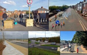
The E3 strategic cycle route connects the residential areas of Whipton, Heavitree and Newtown to Exeter City Centre, predominantly via quiet streets. Using ATF Tranche 2 funding, traffic volumes on some of these streets were reduced, with the Homefield Road modal filter made permanent and the Chard Road modal filter trial extended. This created safer and more pleasant conditions for people of all ages and abilities to walk and cycle. Planters were used to construct the modal filters to improve the local environment.

Chard Road modal filter 
Homefield Road modal filter. In addition, ATF Tranche 2 funding was used to deliver an area-wide consultation to understand the issues affecting street across Heavitree and Whipton residential communities. Further information about this consultation and subsequent progress can be found at devon.cc/exeterstreets.
E9

E9 Cycle Route map The E9 strategic cycle route connects the new Newcourt residential area to Exeter City Centre, via the beautiful Ludwell Valley Park and employment sites at Pynes Hill Business Park, the Royal Devon & Exeter Hospital and County Hall. Using ATF Tranche 2 funding, the modal filter on Ludwell Lane and the bus gate on Wonford Road were made permanent, while the Dryden Road modal filter trial was extended. These schemes removed through traffic from most of the corridor, and complemented the Russell Way pedestrian/cycle crossing and conversion of Magdalen Road to one-way in creating safer and more pleasant conditions to enable more people to choose walking and cycling.

Dryden Road modal filter trial 
Ludwell Lane modal filter. 
Wonford Road bus gate E12
The E12 strategic cycle route runs north-south across Exeter, from the Whipton area via Polsloe Bridge station to the new Marsh Barton station (opening winter 2022) and Industrial Estate. It passes the Whipton, Heavitree and Wonford residential areas via Hamlin Lane playing fields and the Riverside Valley Park. Using ATF Tranche 2 funding, a bi-directional light segregated cycle track was constructed on Sweetbrier Lane, between the Honiton Road and Vaughan Road junction. The scheme also incorporated changes at Sycamore Close and Vaughan Road junctions, giving cyclist priority across the junction.

Sweetbrier Lane The Sweetbrier Lane cycle route will connect to the Rifford Road cycle track being delivered through ATF Tranche 3, providing a continuous north-south route. Together these cycle facilities will improve access to employment, education and green spaces, to help improve physical activity in Whipton and Wonford, which are both priority areas in the Sport England Local Delivery Pilot and Exeter City Council’s Physical Activity Strategy.
Countess Wear
A signalised pedestrian/cycle crossing was constructed across the northern (Rydon Lane) arm of Countess Wear Roundabout, improving safety on a key desire line to employment at Pynes Hill Business Park and for students travelling to Isca Academy (897 students) on foot or by cycle.
City Centre
On Queen Street, Exeter, the western footway was widened using planters, and vehicular traffic restricted to one-way (southbound), with two-way bus, taxi and cycle traffic permitted. This helped facilitate social distancing and improve pedestrian facilities on this busy city centre route, home to Exeter College, Exeter Central station, the Royal Albert Memorial Museum and various businesses. To mitigate the impacts of displaced traffic on St David’s Hill, the Iron Bridge was made one-way (northbound), except for cycles improving the walking and cycling environment in this historic area of the city.

Queen Street, Exeter - Newton Abbot
East to west shared use scheme
The Newton Abbot East to West shared used path provides a walking and cycling link from new and existing housing developments to schools, employment sites and Newton Abbot railway station. Using ATF Tranche 2 funding, permanent signalised crossings were delivered at two locations on the route, at Exeter Road and Jetty Marsh Road, enabling pedestrians and cyclists to safely cross these busy roads.
This also improved links to the recently completed Stover Trail that links Newton Abbot to the market town of Bovey Tracey and onwards to Dartmoor via the Wray Valley Trail.
- Barnstaple
NCN Tarka Trail to Anchorwood
A new shared use path segregated from vehicles connecting the Tarka Trail to new development at Anchorwood Bank. The path completed a missing link in the local cycle network enabling a scenic route for active travel between Barnstaple town centre and the Tarka Trail.

Tarka Trail Station Road
A parallel crossing has been installed on Station Road in Barnstaple. This provides a safer desire line crossing of this busy walking and cycling link between Barnstaple train station and the town centre.

Station Road, Barnstaple - School streets
School Streets restrict traffic outside schools during drop-off and pick-up times, creating a calmer, safer and more pleasant environment. They aim to make walking and cycling to school more attractive, and give parents greater confidence in allowing their children to walk or cycle to school. By doing so, they aim to improve physical activity levels among school children, and reduce vehicular traffic and associated pollution.
Using ATF Tranche 2, three School Streets trialled through ATF Tranche 1 were made permanent, at Bradley Barton Primary School in Newton Abbot, and Ladysmith Primary School and Whipton Barton Federation in Exeter. This was following consultation with parents, school staff and local residents, which showed 86% of respondents wanted the School Streets to be made permanent. Among respondents, there was a 20% reduction in car use for school journeys and an 18% increase in active travel.
For more information about School Streets and the process for creating additional School Streets, please visit the Council’s School Streets webpage.

School Streets


