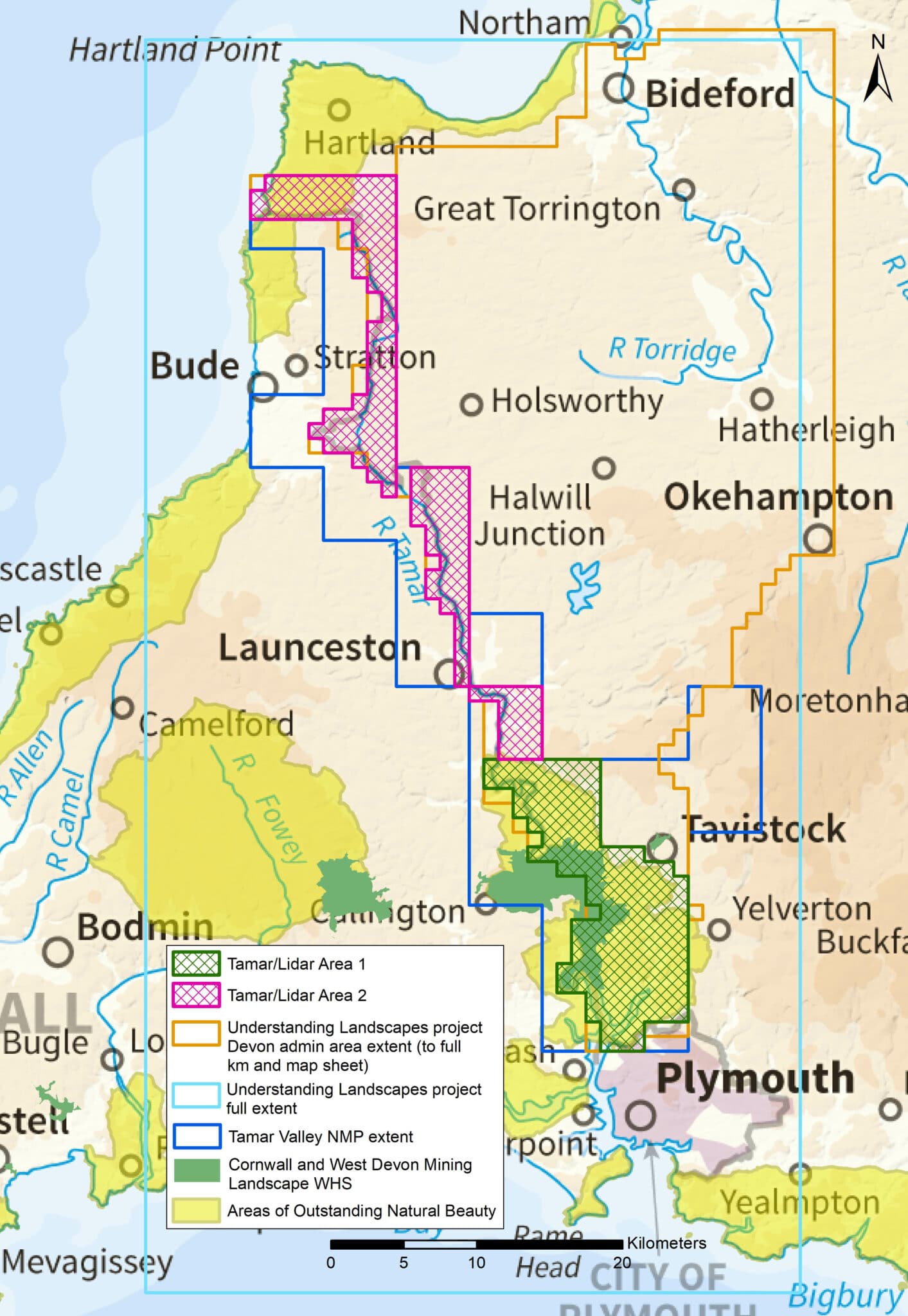
This project was developed around restrictions necessitated by the coronavirus pandemic, and used only digital resources. The survey assessed lidar-derived imagery to interpret, map and record visible archaeological sites and landscapes in the Tamar Valley. It builds on an earlier aerial survey of the Tamar Valley, part of the Cornwall and Isles of Scilly National Mapping Programme (NMP) project, which was undertaken before lidar imagery was available. The project provided an opportunity to work with the University of Exeter’s Understanding Landscapes team, to support and enhance community-led interpretations that were generated from assessment of lidar imagery.
The collated information created an archaeological map and descriptions to help inform heritage management. The information has been recorded on the Devon Historic Environment Record. Individual monument records are available online via Heritage Gateway and are mapped on the Devon Environment Viewer. A report summarising the main themes to emerge from the survey, and recommendations for similar future surveys, will be available as part of the Historic England Research Report Series.
The survey has recorded evidence of archaeological remains dating from the Bronze Age to the Second World War. The lidar data has particularly enhanced knowledge of Bronze Age mortuary monuments, medieval field systems and deserted or shrunken settlements, and medieval and later streamworks and mines. Many of these survive only as subtle earthworks or had been obscured by tree cover for many years, so had not been identified during earlier surveys.
A team from AC archaeology carried out the survey, hosted by Devon County Council and funded by Heritage Protection Commissions (8359) and the Culture Recovery Fund for Heritage. It was completed in summer 2021.
Read more about other aerial investigation and mapping projects in Devon (formerly called ‘National Mapping Programme’ or ‘NMP’).


Prehistoric funerary monuments
Barrows were one of the monument types most frequently identified by the Understanding Landscapes volunteer community, and they were particularly found on the higher plateaux and ridges in the north of the project area. In Devon excavated examples of these burial mounds are typically simple in form and Early Bronze Age in origin, though with some Middle and Late Bronze Age examples and reuse.
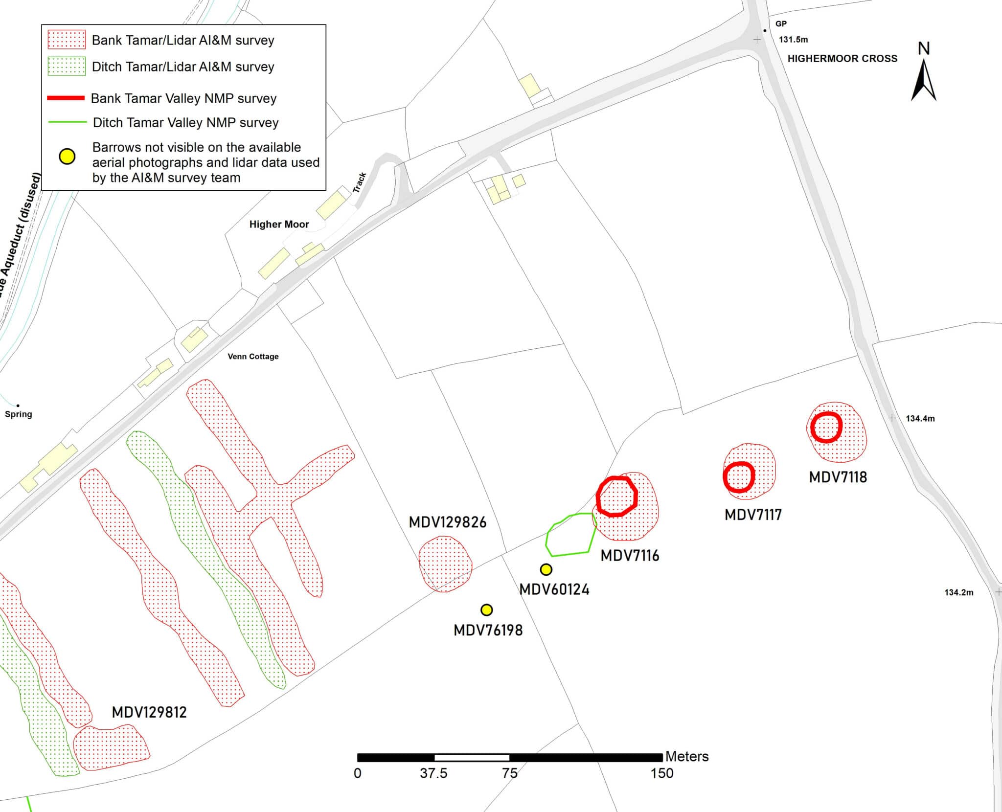
Although over half were new to the HER, most were recorded near to other barrows, indicating a more complex and dense funerary landscape than had previously been demonstrated. The value of revisiting areas that had previously been surveyed using only aerial photographs is apparent from the barrow cemetery at Highermoor Cross. Here two additional mounds were recorded from lidar, three of the mounds visible on the lidar were considerably wider than had been mapped from the aerial photographs during the earlier NMP survey, and two barrows that had been recorded on the HER were not seen on the lidar or mapped from aerial photographs. The barrows not seen on the lidar may have been levelled in the later 20th or 21st century, and further work could target sites like the mounds that appear wider on the lidar, to ascertain whether the transcription from the aerial photograph was less accurate, or whether subsequent agricultural activity had lowered and spread the earthworks.
More often it was the case that additional probable barrow mounds could be added to the record, where these were visible as subtle earthworks (eg near Maddacleave Wood), or in areas where vegetation cover makes earthworks difficult or impossible to identify from aerial photography, for instance at East Gorvin Plantation.
Medieval settlements and field systems
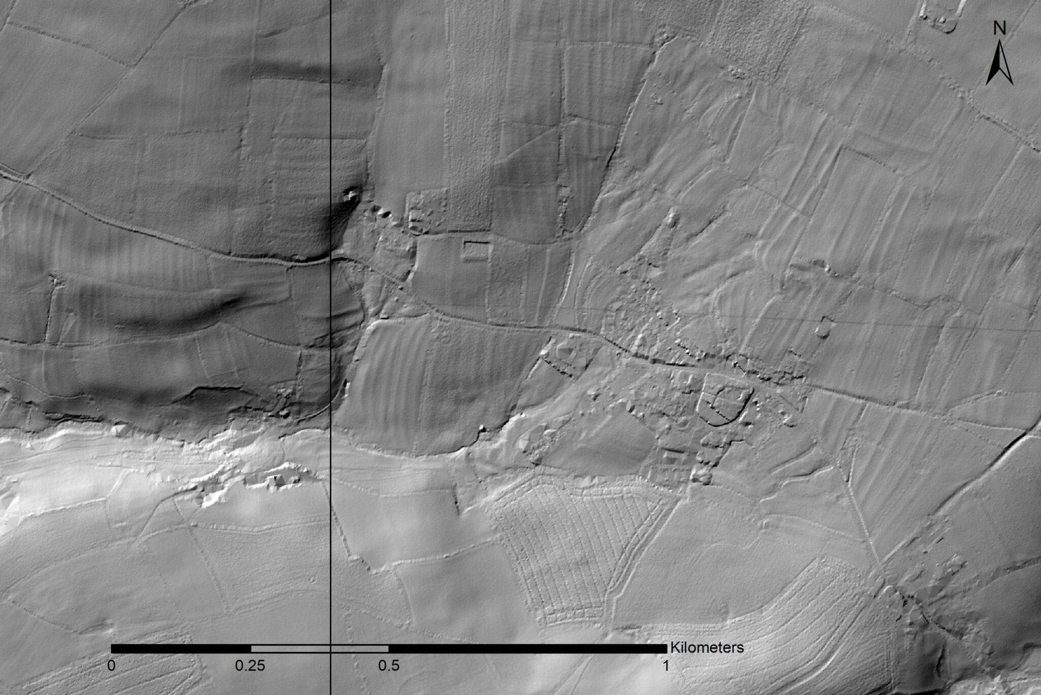
Extensive areas of parallel, curvilinear earthwork banks, for example around Milton Abbot, provide a glimpse into a medieval field pattern that in many parts of Devon has been lost. The transcriptions complement the boundaries previously recorded from aerial photographs and give a much more complete picture of the enclosed strip fields that once surrounded settlements in the Tamar Valley.
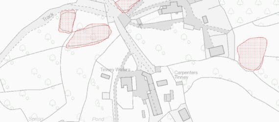
Other elements of the medieval landscape that could be identified as partial and often subtle earthworks are numerous possible infield boundaries, tracks or holloways and building platforms. The majority were associated with existing hamlets or farmsteads, suggesting that these settlements had contracted since the medieval period, for example at Tinney. A few complexes were found in isolation, suggesting the complete desertion of some settlements, for instance at Forda Mill.
The large number of field systems and deserted or shrunken settlements identified as earthworks in the Tamar Valley tell of significant historic changes in land use. Improvements in agricultural practice and expansion of the agrarian economy coupled with difficult economic conditions during the 19th century may have made smaller holdings less viable, resulting in settlement contraction, farm engrossment and boundary loss. In the Tamar Valley the role of mining and its related industries in the post-medieval and modern period also transformed settlement and field patterns. The demand for labour might be reflected in the complete or partial abandonment of farmsteads, hamlets and villages, with workers relocating to larger towns such as Tavistock, or mining settlements such as Calstock or Gunnislake.
Industry
Extractive industries have shaped the Tamar Valley since the medieval period, peaking in the 18th to early 20th century with over 100 working mines. The area south-west of Tavistock falls within the Cornwall and West Devon Mining World Heritage Site, and it is here that the majority of the industrial remains can be found.
One unusual feature visible on the lidar images is known as the Lumburn Leat. This 16km long watercourse was constructed in the late 15th century to divert water to the silver lead mines of Bere Ferrers, powering pumps that drained the deep workings. Silver mines here date to at least the 13th century, and the expertise and labour necessary to create this engineering wonder, in some places cut through bedrock, reflects the lucrative nature of this industry until its demise in the 16th century. A number of segments of the leat had already been recorded on the HER, and the lidar survey has been able to add to these, identifying earthwork survival at several places including over 300m at Slymeford Farm.
The earliest references made to tin working in the survey area are at Bucktor in 1508 and at Crowndale in 1539, although earlier exploitation is likely, and both streamworks and openworks have been recorded. Along the Walkham Valley for instance, large areas of linear and curvilinear earthwork banks and channels perpendicular to the river are the remains of spoil and trenches or ‘tyes’ that were hand dug incrementally through the tin ground. As well as extending the known area of these works, more could be inferred about their character. Large areas of poorly defined earthworks for example indicate possible reworking of deposits. Lidar also provides a good indication of survival, which in the Walkham Valley included additional features such as the leat that provided water for washing the tin.
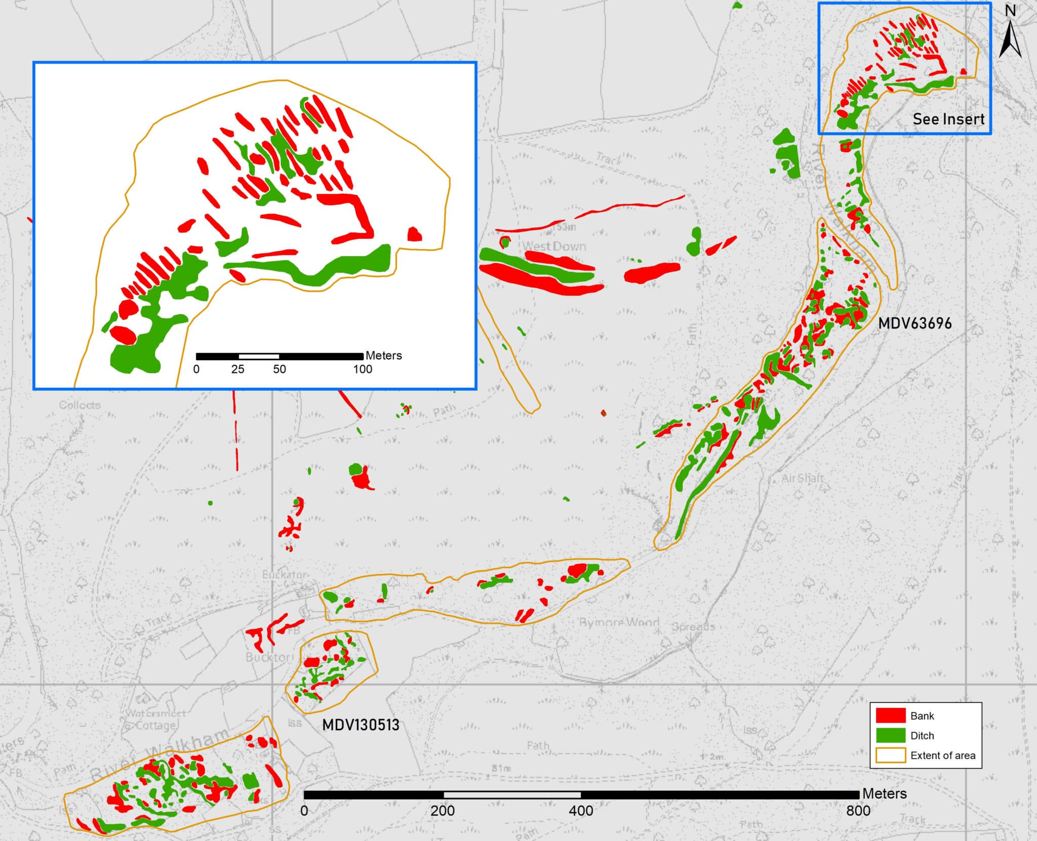
The value of using several different visualisations is demonstrated by streamworks such as those at Broadwell Wood, where newly recorded earthworks were much clearer on a single direction hillshade visualisation than on a 16 direction hillshade of Environment Agency lidar. These features were not visible on the Tellus lidar, and can sometimes be hard to tell from geological formations, and it is likely that further sites will be identified in the future when full coverage of high resolution EA lidar is available.
By the mid-19th century copper mining had become profitable and in some locations subsumed earlier tin workings, for instance at Wheal Crowndale. The shafts, adits and spoilheaps of the later mines were very frequently recorded from lidar, and greater detail could be seen at many of these sites, compared to what had previously been recorded from aerial photographs and historic maps. In some cases this meant that earthworks could be mapped in areas where the ground surface is obscured by tree cover (for instance at Bedford United Mine), whilst the lidar confirmed that a number of features at other sites had been levelled (e.g. East Wheal Crebor).
Your comments
Would you like to share additional information on any of the sites we recorded from lidar, or do you have a different interpretation? Let us know! We read all submissions but unfortunately due to the volume of responses we are unable to respond personally to every comment.