This survey aims to assess all readily available aerial photographic sources and lidar derived imagery, to interpret, map and record all visible archaeological sites and landscapes between the narrow coastal strip (previously surveyed as part of the South Devon Coast Rapid Coastal Zone Assessment Survey – RCZAS) and Dartmoor National Park (which had been assessed as part of a pre-National Mapping RCHME Survey).
Between 2018 and 2019 an archaeological aerial investigation of the area between Haldon Ridge and the Dart Valley was undertaken by a project team of staff from AC archaeology. A second area, between Plymouth and the Avon Valley, was investigated by the same team immediately afterwards, completing in 2020. Both projects were funded by Historic England and hosted by Devon County Council within the Historic Environment Team.
A number of different themes became apparent as the projects progressed. These are summarised below but are covered in greater detail in the survey reports, which are available as part of the Historic England Research Report series. Individual monument records are available online via Heritage Gateway and are mapped on the Devon Environment Viewer.
Read more about similar aerial investigation and mapping projects in Devon (formerly called ‘National Mapping Programme’ or ‘NMP’).

Area 1, Haldon Ridge to the Dart Valley
This 290 square kilometre area contains a high proportion of buried archaeological sites which are visible as cropmarks, as well as good survival of nationally significant earthworks.
The project examined almost 5000 thousand aerial photographs loaned from the Historic England Archive, as well as collections held by Devon County Council and modern digital datasets of vertical aerial photographs. Use of airborne laser scanning imagery allowed otherwise hard-to-detect earthworks and structures to be mapped and recorded.
In total, just under 1700 archaeological or historic sites were identified from the aerial imagery and recorded on the Devon and Dartmoor Historic Environment Records (HERs). 1260 archaeological sites were new to the record, an increase of 21%.
Field systems and farming
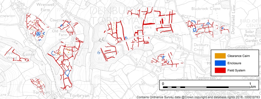
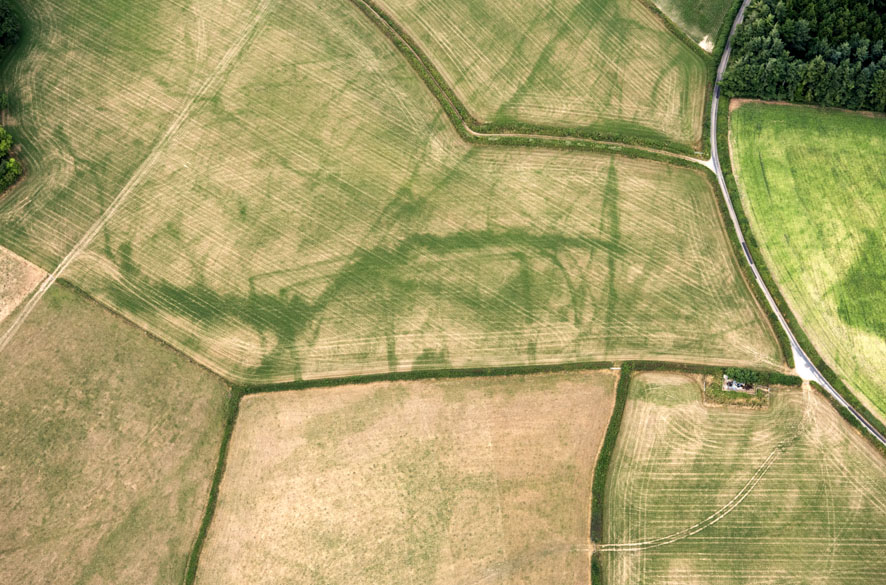
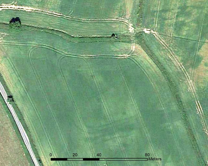
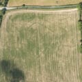
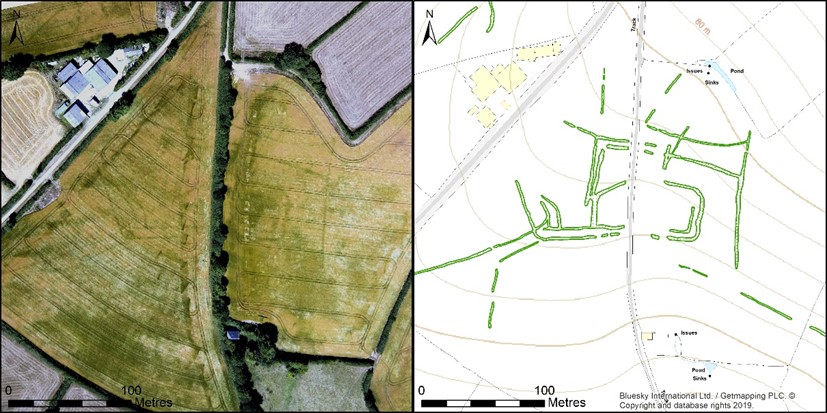
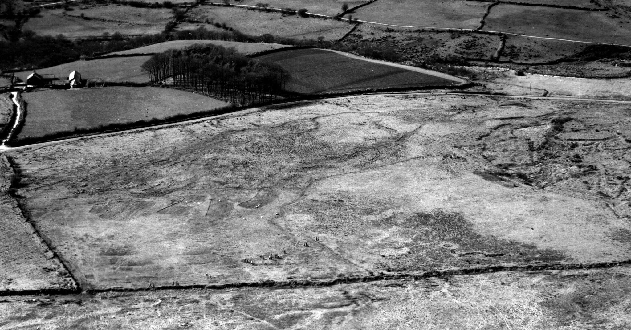
In a predominantly rural county such as Devon, it is unsurprising that evidence of field boundaries and field systems were a major theme to emerge from this survey. However, with the exception of the Dartmoor reaves, evidence of pre-medieval land management is relatively rare across the county. So the remains found in the project area are particularly exciting, comprising widespread and well-preserved earthwork remains of Bronze Age to Romano-British field systems on the limestone plateaux.
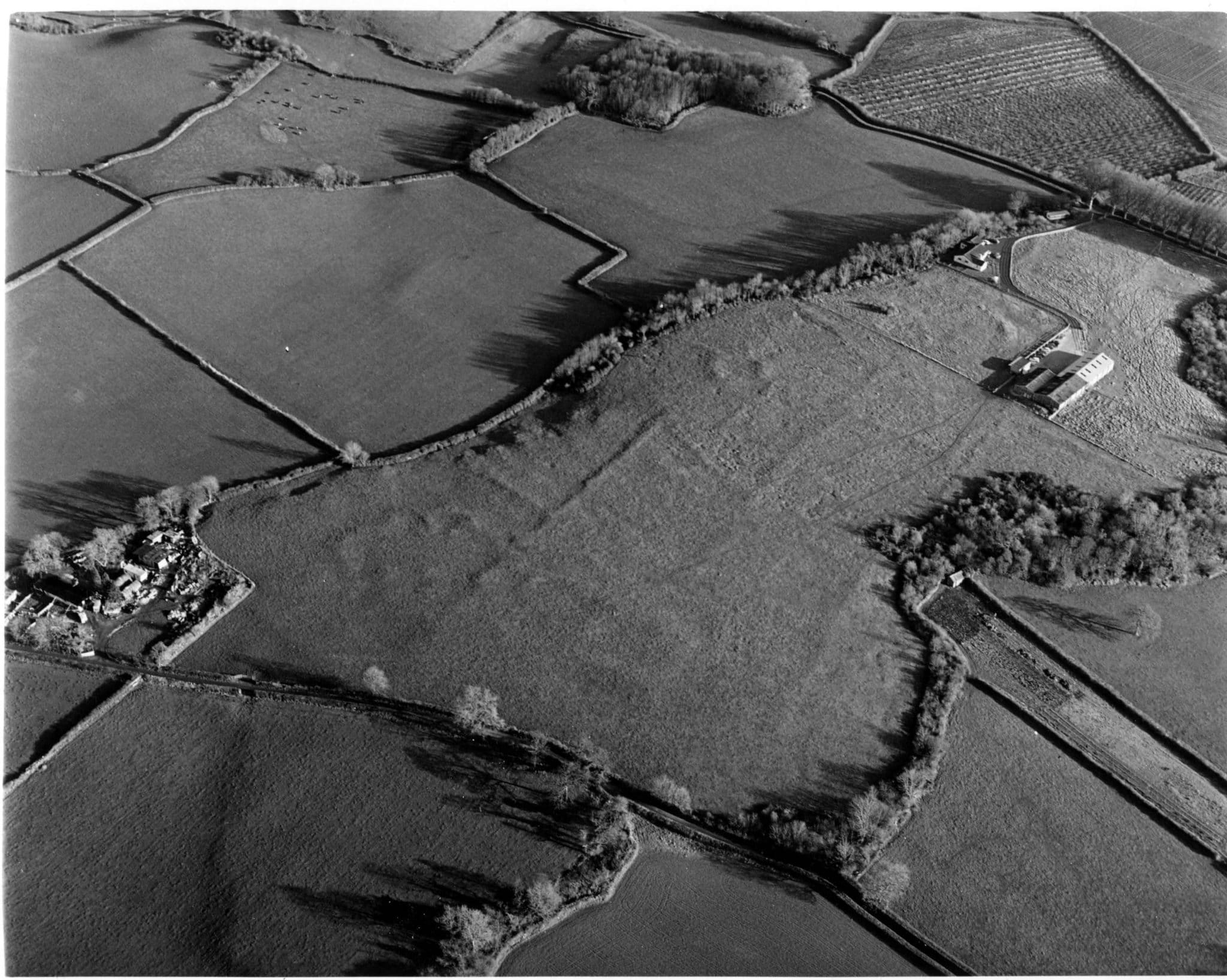
Evidence of these field systems was first recorded at Dainton during the post-war period, but it was not until the late-1970s to early-1980s that a comprehensive survey recognised their exceptional and extensive nature. Seventeen field systems were identified within the project area, including examples at Tornewton, Torbryan Hill, Deer Park, Clennon Fields and Stallage Common.
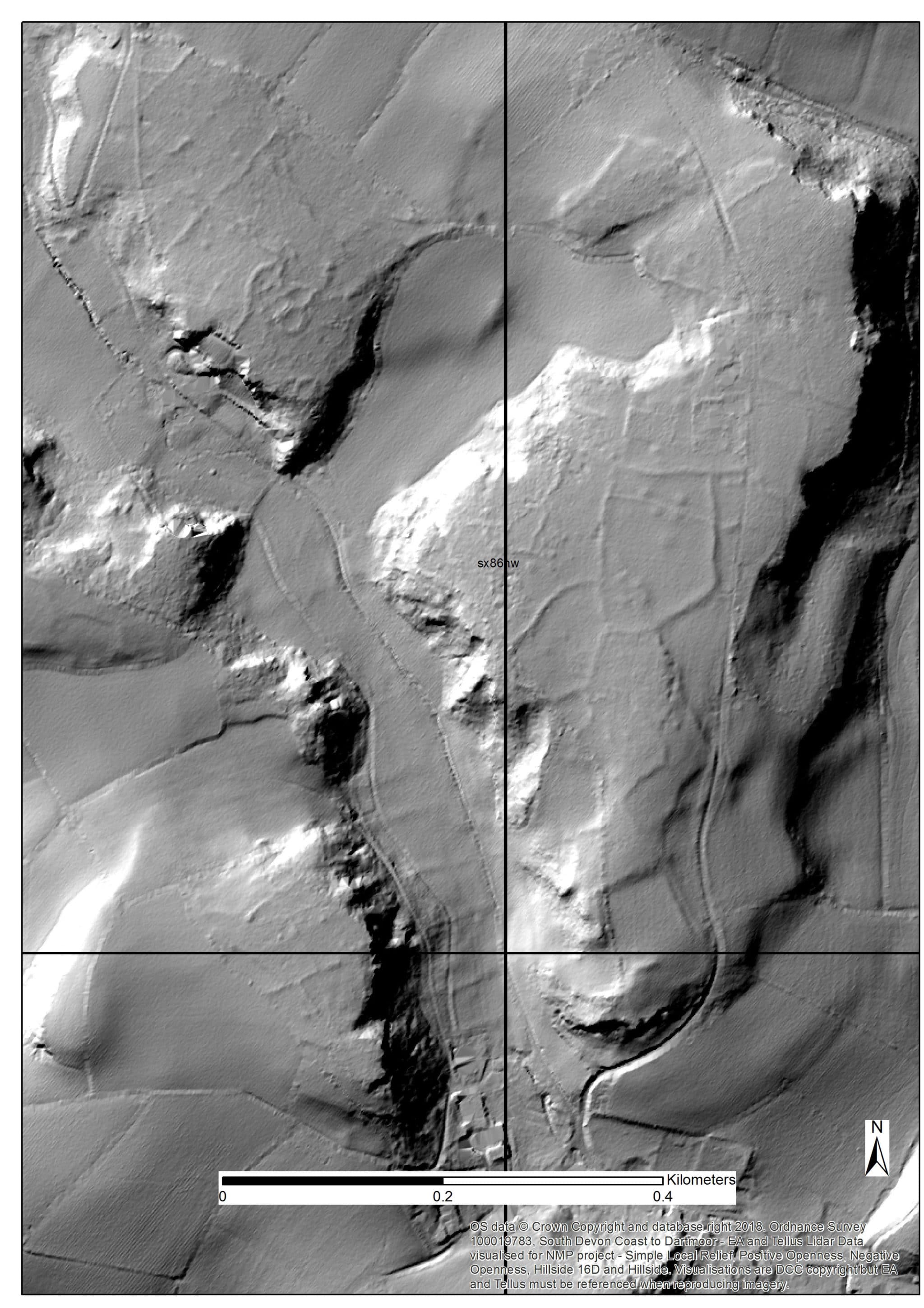
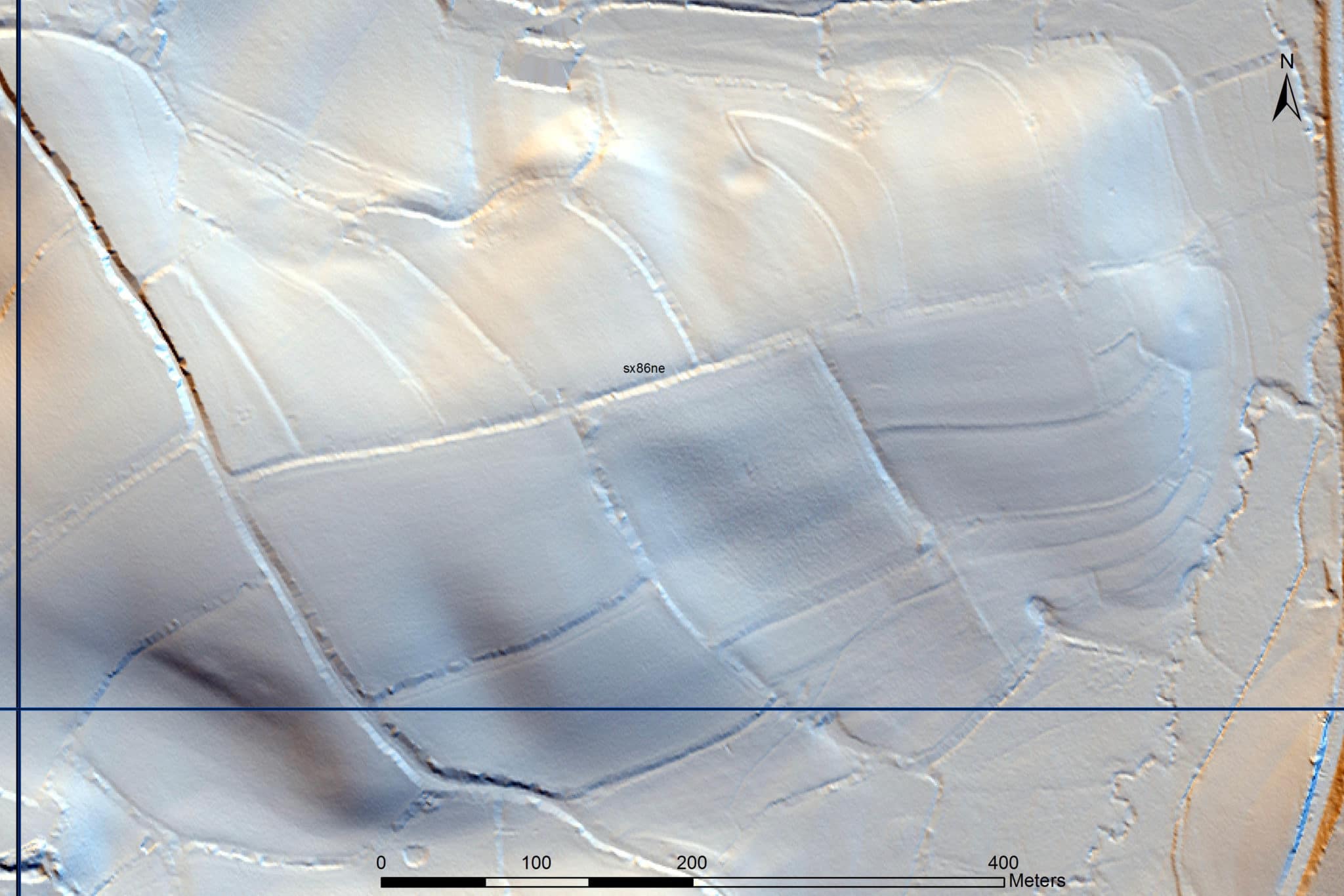
Although many were visible on aerial photographs, use of lidar visualisations provided significant new information. Lidar was instrumental in recognising a number of previously unknown field systems, such as at Home Park, Kiln Orchard, Dyer’s Wood and Fairfield Farm.
As well as providing greater clarity and definition, the survey has in most instances significantly increased the known area of previously identified field systems; the area mapped on Torbyran Hill, for example, has increased threefold.
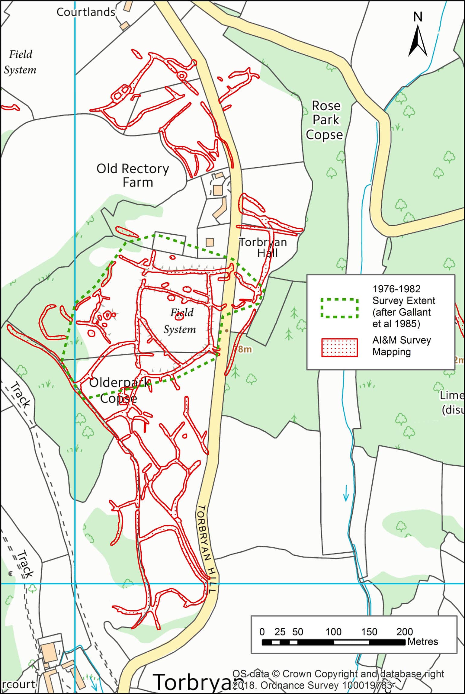
The location of all the field systems on marginal land on the limestone plateaux, and their proximity to each other, suggest they may once have been part of a more extensive, and probably integrated, network of fields.
This could perhaps have served a group of communities engaged in contiguous land management. The survey recorded over 40 enclosures associated with these field systems, suggesting that communities lived as well as farmed here.
Many of the current field boundaries are on similar alignments to the disused boundary banks, an indication perhaps that the prehistoric field systems were previously larger, and have influenced (or been incorporated into) later field patterns.
The remains of later fields were very frequently seen all across the project area, and in terms of numbers the most common monuments recorded were medieval and post-medieval field boundaries.
Their buried remains were often visible as cropmarks, but they were more commonly noted as earthworks on lidar images. Only the field boundaries not depicted on the available historic maps were recorded during the survey, so the high number of field boundary records demonstrates considerable field boundary loss prior to the Tithe map of the mid-19th century. This was particularly evident in the south of the project area.
Some striking and extensive examples of medieval field systems were visible as strip lynchets on the slopes of Kerswell Hill and east of Greatoak Cross. Examples of ridge and furrow, generally rare in Devon, were recorded at West Ogwell and Bickington.
Buried enclosures revealed as cropmarks
The dry summer of 2018, combined with the free draining soils in parts of the project area, created ideal conditions for the detection of buried archaeological sites visible as cropmarks. Historic England aerial reconnaissance made some exciting discoveries in the project area, such as the possible late prehistoric and Romano-British settlements at Ambrook Farm and east of Penn Bungalow.
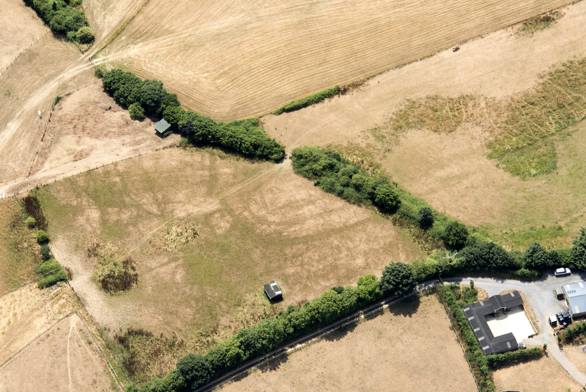
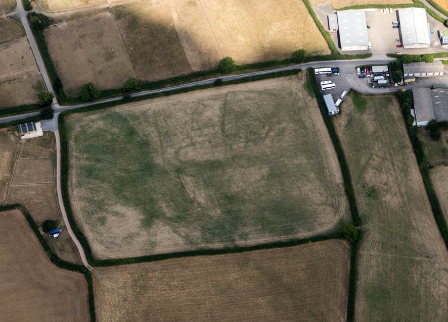
Over 90 enclosures were recorded during the survey, around 20% of which were newly recorded, and their distribution shows a strong correlation with slate and breccia geologies. Until recently, it was thought that these lowland enclosures were isolated settlements. However, geophysical survey and excavation at Dainton Elms Cross, Ipplepen, demonstrates that apparently isolated Iron Age and Roman enclosures may in fact be associated with field systems.
Streams of tin
Devon’s tin industry was fundamental to the county’s economy between the medieval and early post-medieval period. It was synonymous with the granite uplands of Dartmoor, where the massive scale of workings left few valleys unscathed, for example at Swincombe Head. The only other sources of tin in the UK are found in Cornwall, such as on Bodmin Moor.
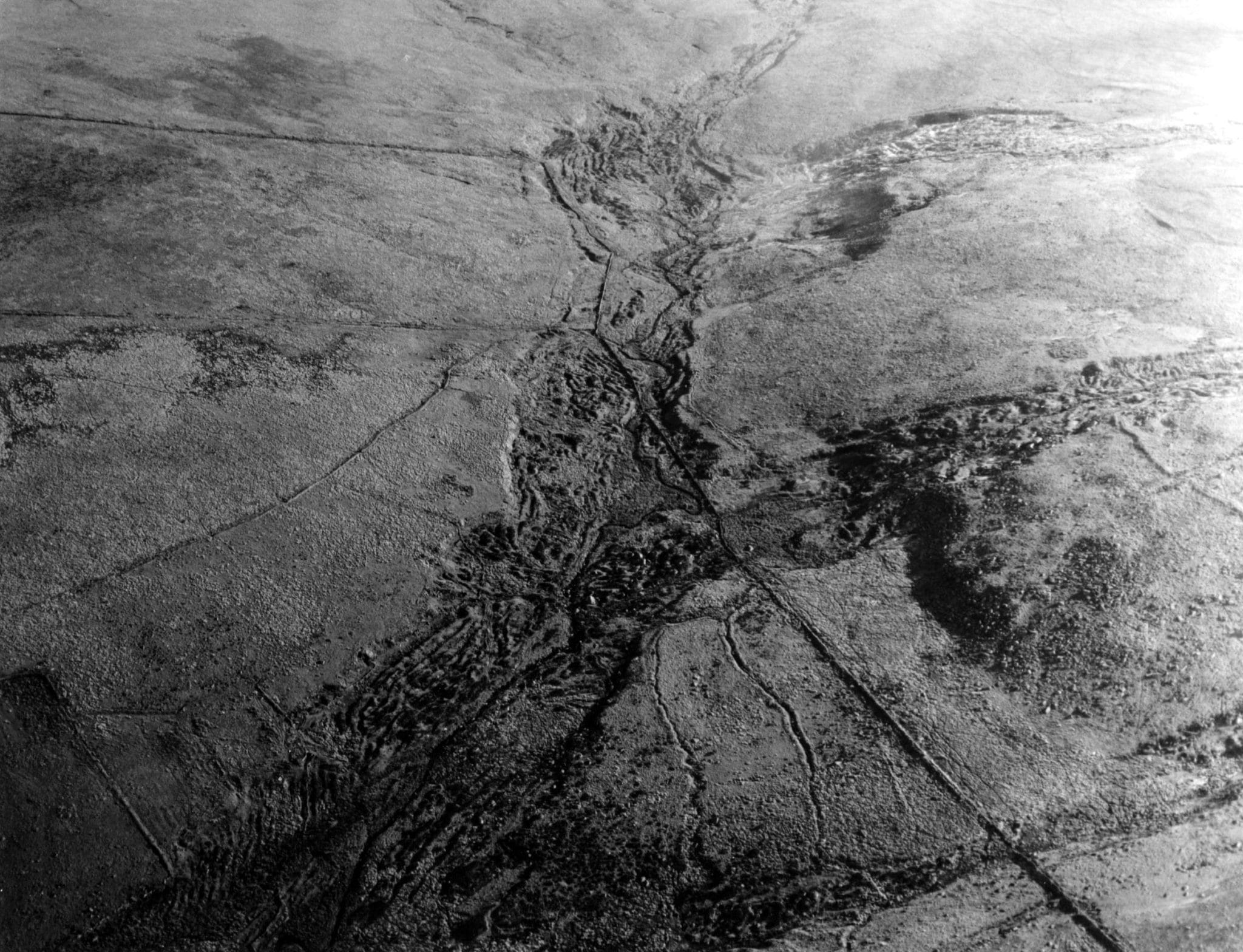
The most common and easiest way to extract the tin was a technique known as tin streaming, exploiting the ‘tin streams’ that had formed when tin ore eroded from the parent lode was deposited along river valleys or on hillslopes or dry valleys. Although most of the project area lies beyond the rich tin-bearing Dartmoor granite, large quantities of tin ore eroded from the parent lode over thousands of years were deposited by alluvial action along the Bovey valley, which bisects the project area.
Evidence of tin streaming dominates the results of the survey in the north-west corner of the project area around Bovey Tracey and Heathfield. The extensive nature of these earthworks suggests that the tin industry in this lowland zone was carried out on a much greater scale than previously thought, and this area perhaps deserves greater academic attention, having until now been somewhat sidelined in preference to Dartmoor.
Lidar was particularly useful in the identification and recording of tin working sites, since most of these former workings have long since been covered by woodland or almost levelled through ploughing, making the earthworks virtually undetectable on aerial photographs. In total 25 monuments interpreted as streamworks or tin working complexes were recorded by the survey, of which 20 were new to the HER.
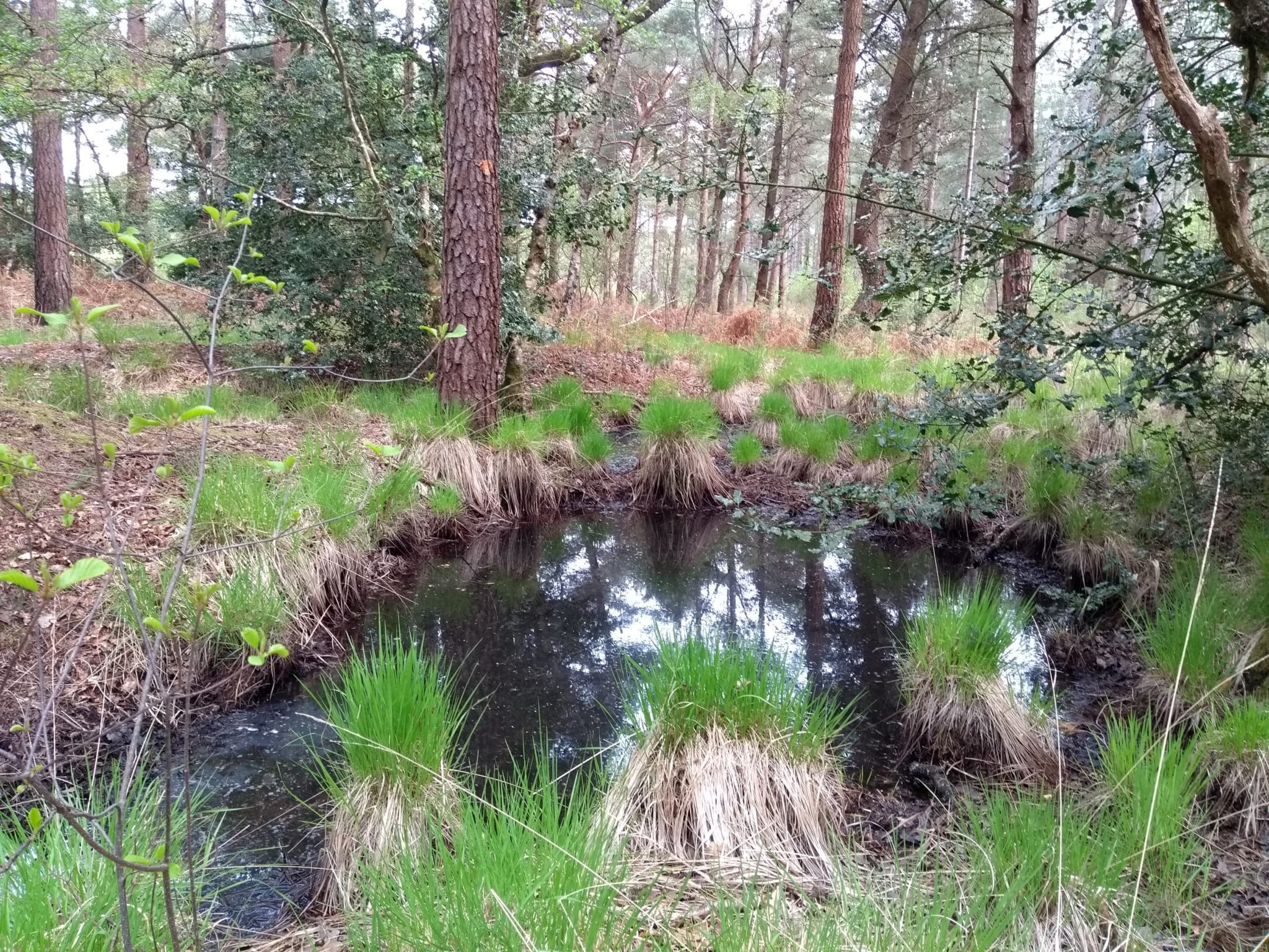
The water channels, pits and spoil heaps of a possible streamworks were recorded at Pitt’s Plantation; much of this area was converted to forestry in the 19th century, but the ‘Pitt’ element of its name must surely reflect the survival of extensive earthworks relating to the earlier industry.
A different type of land reuse can be inferred in the adjacent parkland at Stover, where two 17th or 18th century ornamental tree mounds may have utilised the loose spoil of former tin workings. The workings here might have once extended further to the south, but if so would have been levelled by the subsequent Second World War United States Army hospital and later Polish resettlement facility.
The amorphous and seemingly random form of the earthworks recorded at Pitts Plantation and at other lowland sites such as Staplehill Copse, Bovey Heath, Parke Wood and Wifford are in contrast to the more systematic workings found across Dartmoor. This could suggest that the tin deposits in these two geographic areas were worked in different ways, probably as a result of differences in topography and geology.
Fortification and control
In contrast to the neighbouring South Devon Coast RCZA project, we identified relatively few sites that could be described as defensive or military in origin.
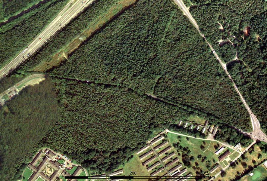
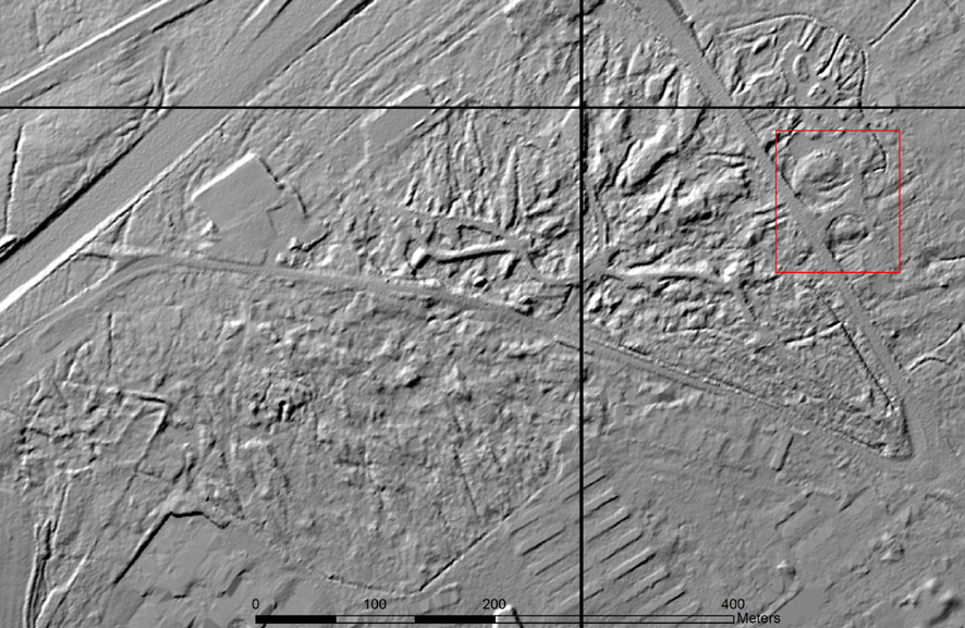
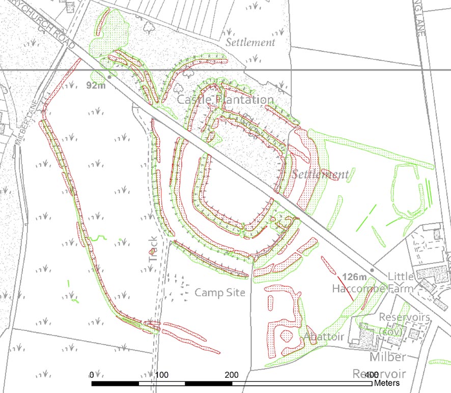
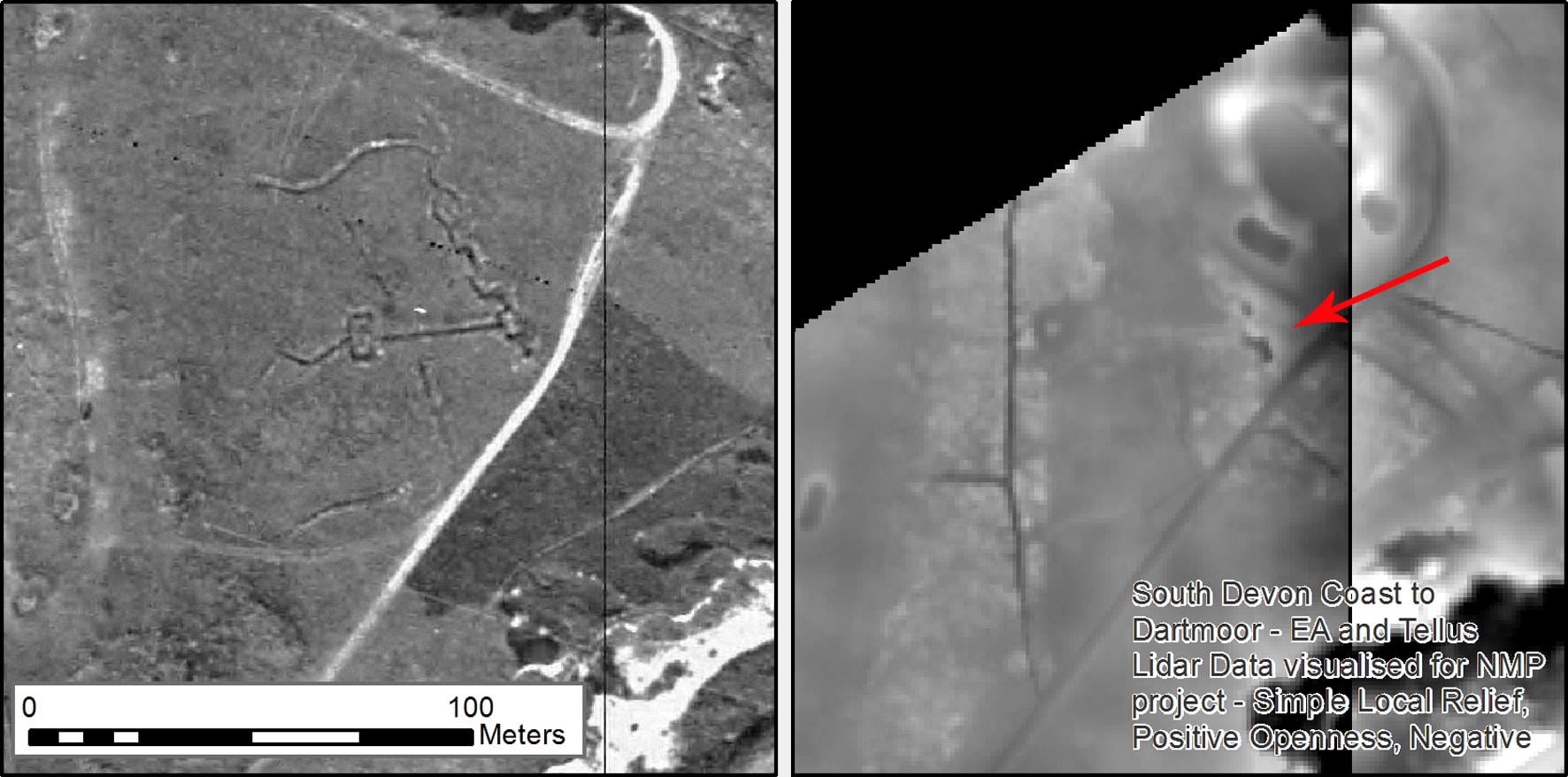
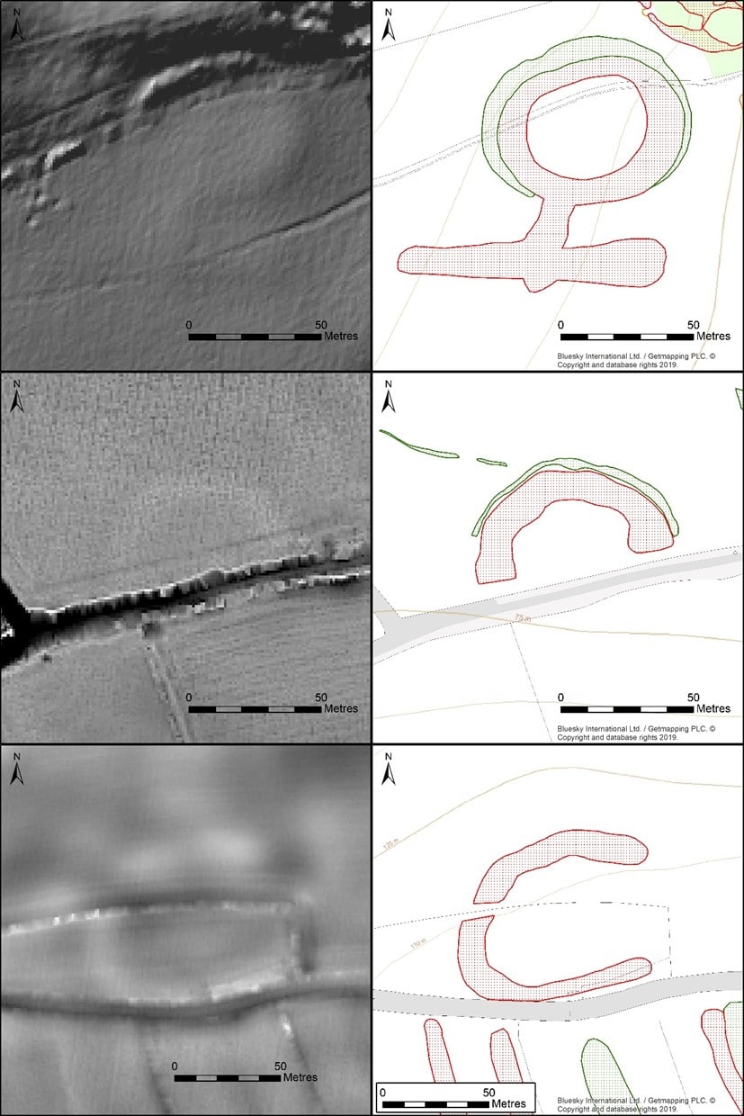
For some of the earliest defended sites visible on aerial imagery, the Iron Age hillforts of Milber Down, Denbury, Berry’s Wood and Castle Dyke, the use of various lidar visualisations has greatly assisted in mapping earthworks that are partly, or wholly, covered by woodland. The survey has added greater detail or new elements to some records, for example the earthwork ditch and banked ramparts which define two outer circuits within the northeast corner of Milber Down.
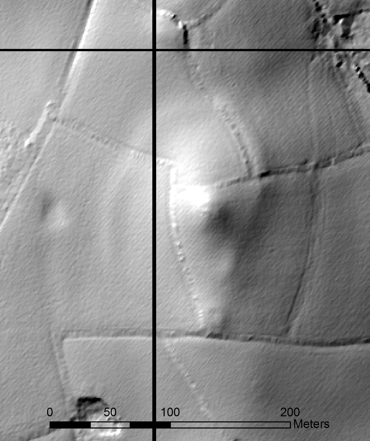
A newly recorded possible hillfort was visible as earthworks south of Coppa Dolla Farm, located approximately 1.5km to the south-west of Denbury hillfort. This oval enclosure occupies a prominent ridge-top position, which offers commanding views across the surrounding countryside. At 1.3 hectares, it is much smaller and less well-defended than other hillforts in the project area, and may therefore have fulfilled a different function. Further work, such as analytical earthwork survey or geophysical survey, could help to clarify the original purpose of this monument.
Two particularly notable Roman defended sites were identified from cropmarks. A possible Roman fort or camp north of Dainton Elms Cross was first recorded as a double-ditched enclosure during aerial reconnaissance in the 1990s, but more extensive cropmarks photographed in the dry summer of 2018 provided further detail and enabled reinterpretation. A possible fortification at Old Walls Hill is similar in style to the Roman signal station at Stoke Hill, Exeter.
The intriguing remains at Round Covert, Hennock have been subject to various different readings, although reassessment of the evidence during this survey supports an interpretation as a temporary Civil War emplacement. Other interesting earthworks likely to be of this date include the possible breastwork on Bovey Heath thought to be associated with the ‘Battle of Bovey Heath’ fought in 1645.
Wartime and immediate post-war aerial photographs are excellent for identifying sites dating to the two World Wars. The impact of the First World War can still just be traced on the landscape at Teignmouth golf course, where the crenelated pattern of practice trenches were recorded from 1940s aerial photographs. Lidar data shows that they survive as subtle earthwork banks and ditches.
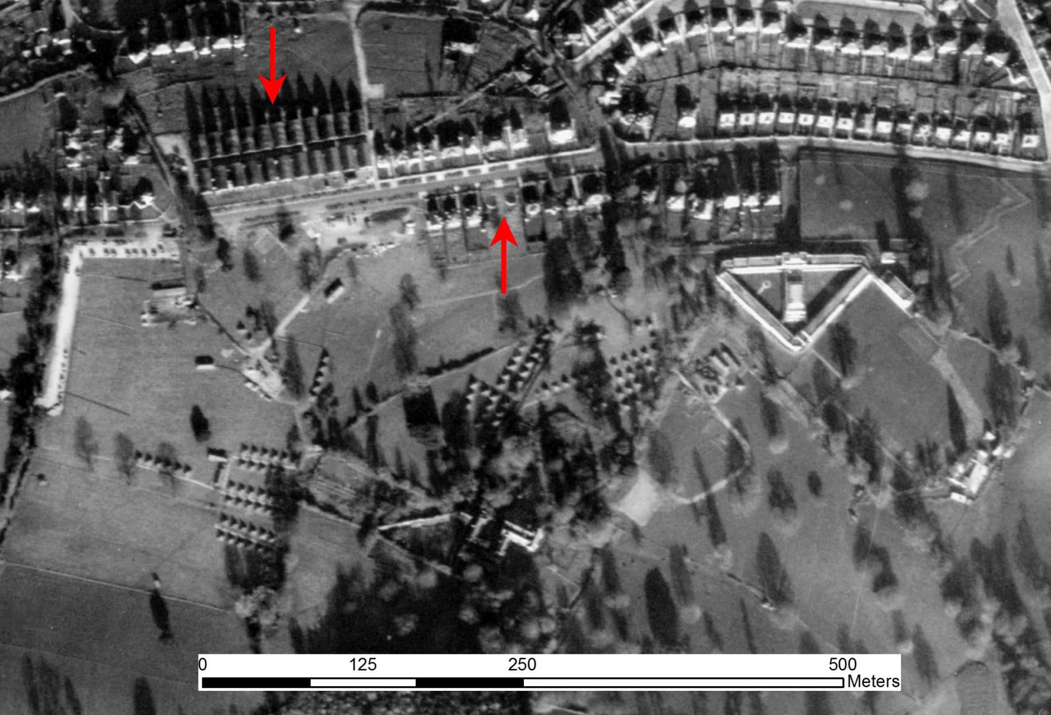
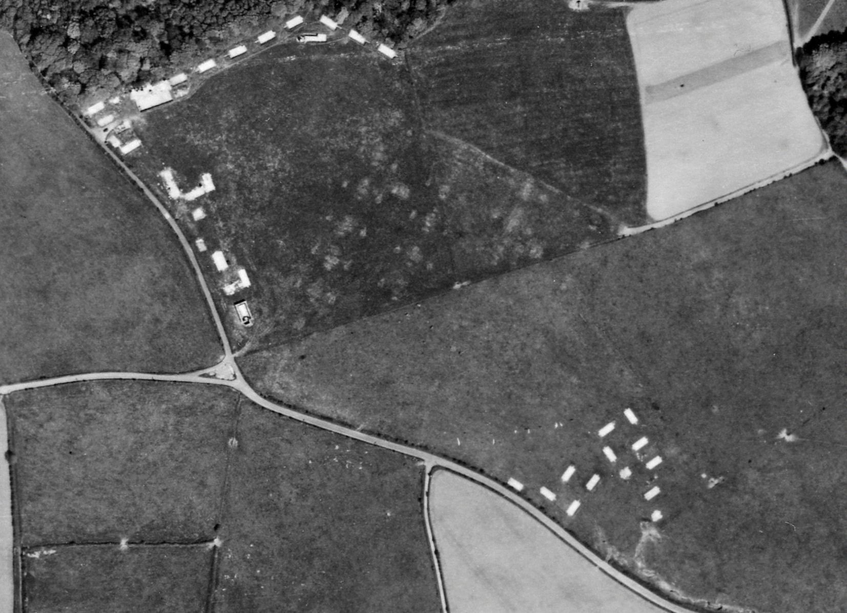
A far greater variety of Second World War sites were recorded. We can see evidence for construction of facilities for civilian defence, especially in the built-up areas of Torquay, dating to the early stages of the war when the airborne threat was at its greatest. Emergency Water Supply reservoirs were located in areas where water supply was at risk of disruption due to air raids, and a number of examples were recorded including at Main Avenue, Plainmoor Stadium, St. Mary’s Church and Shiphay Avenue. Air raid shelters for civilians were recognised at Newton Abbot, Teignmouth and Torquay. The risk from enemy bombing raids in the southwest was, however, still considered to be lower than in London, and Prudential Insurance temporarily moved their staff from the City into purpose-built offices, visible on 1940s aerial photographs in Shiphay, on the outskirts of Torquay.
Later in the war, as Allied forces were preparing for the invasion of Europe, the emphasis shifted towards construction of temporary infrastructure such as army camps at Denbury and Stover Park, naval stores depots on Knighton Heath and Heathfield and a hospital at Ilford Park, later reused as a Polish resettlement facility. Camps recorded in the grounds of two Torbay schools at Audley Park and Torquay Girls’ Grammar were new to the HER.
Religion and ceremony
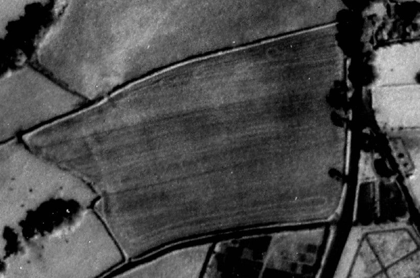
Neolithic ceremonial or funerary monuments are rare, so it was interesting to see the remains of a possible long barrow west of Sandy Mount, which was visible as an elongated cropmark on aerial photographs taken in 1950. Sadly this area has since been subsumed by a modern housing development, making any positive identification of this feature unlikely.
Monuments interpreted as Bronze Age round burial mounds were more frequently encountered, including newly recorded examples at Little Haldon and Ideford Common which seem to form part of wider barrow cemeteries that were already documented, and a newly recorded group of four mounds at Luscombe Castle (MDV124754, MDV124755, MDV124756 and MDV124758).
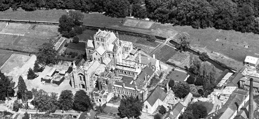
Some of the earliest aerial photographs available to the survey team included images of the medieval (and later) site of Buckfast Abbey. As well as documenting the evolution of the formal landscape in the 20th century (MDV123371; MDV123375) these early aerial photographs give us a visual insight into the changing recreational and working lives of the monks in the immediate pre- and post-war period (MDV7808; MDV20064).
Area 2, Plymouth to the Avon Valley
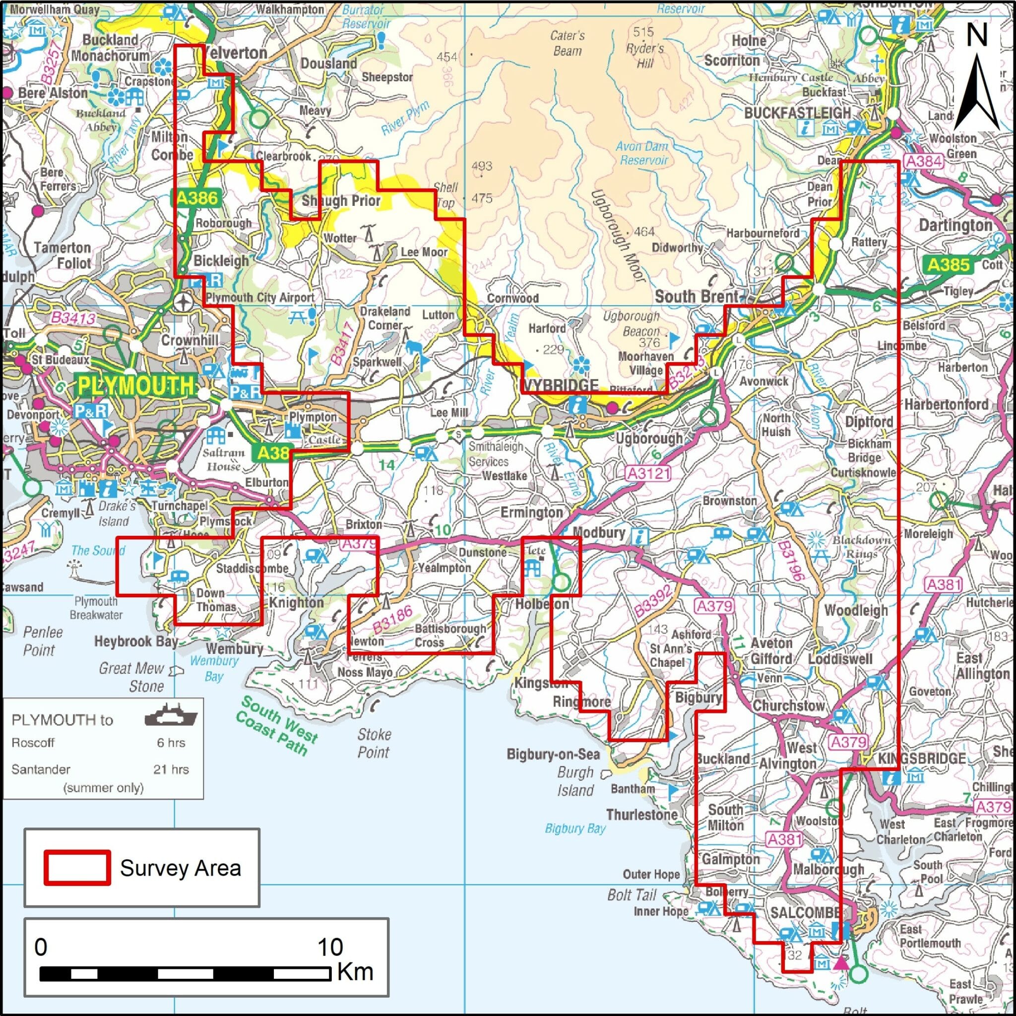
This second phase covered 355 square kilometres between Plymouth and the Avon Valley. The survey has recorded evidence of buried and above ground archaeological remains dating from the Neolithic period to the Cold War.
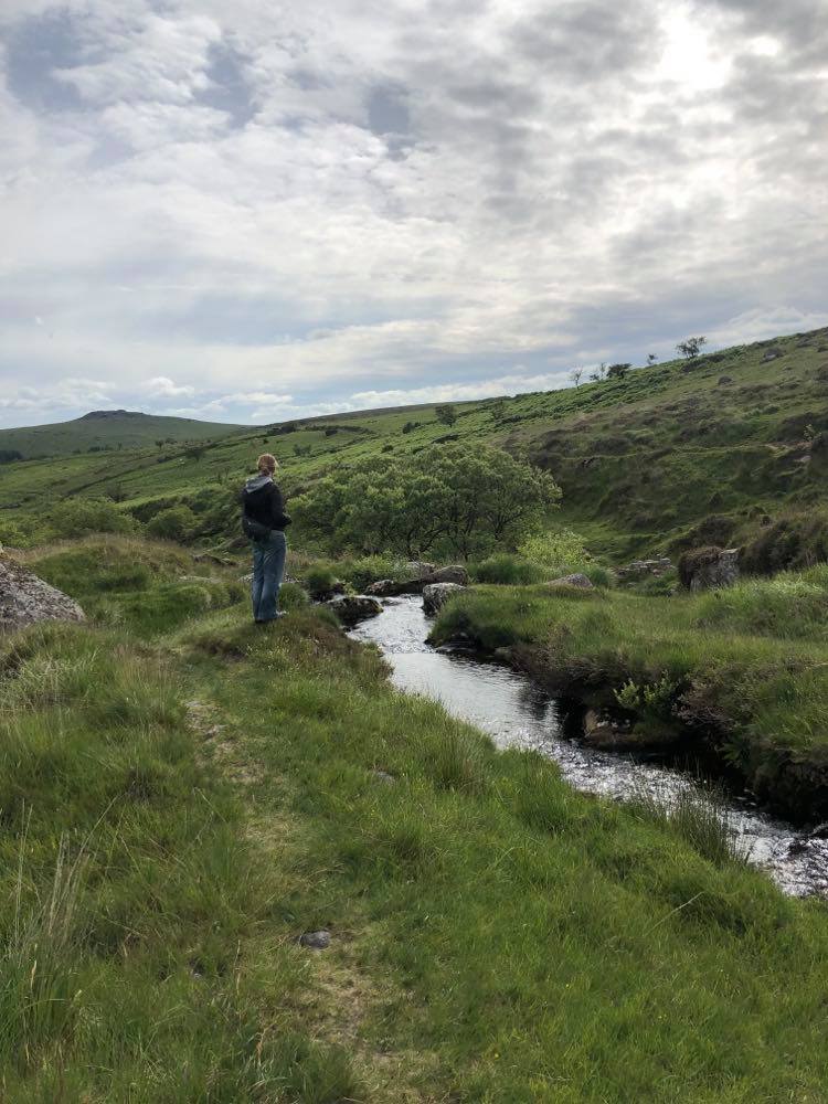
Notable sites include a possible Neolithic tor enclosure, the palimpsest of iconic Dartmoor Bronze Age monuments such as stone rows, barrows and reaves (early field systems), embanked earthwork enclosures of probable Iron Age or Roman date, medieval strip fields and deserted settlements, medieval and later tin mining and peat cutting remains, civil and industrial water supply infrastructure, china clay quarries and modern conflict landscapes from the 18th century to the Second World War.
Different types of prehistoric enclosure
Prehistoric boundaries and enclosures of different forms were recorded during the survey, ranging from stone built possible Neolithic tor enclosures and the extensive Bronze Age land divisions on Dartmoor known as reaves, to the numerous later enclosures visible as cropmarks or earthwork banks.
Reave systems appear to be laid out with little regard for topography, covering large areas with parallel north-east to south-west aligned boundaries, for instance on the southern periphery of Dartmoor National Park at Crownhill Down and Shaugh Moor. In many places they can be traced in later field systems where the prehistoric boundaries have become fossilised in the medieval field pattern, for instance at Ivybridge. The survey has been able to enhance many of the records of reave systems and associated hut circle settlements by adding additional detail visible on both lidar and aerial photographs, and has also identified possible additional reave systems some distance from Dartmoor, as at Leighmoor Cross.
The exceptionally dry summer of 2018 resulted in excellent conditions for the recording of archaeological cropmarks. Specialist aerial reconnaissance undertaken by Historic England allowed recording of newly identified enclosures of probable later prehistoric or Roman date. This included a double-ditched enclosure near Hemerdon, Sparkwell, which subsequent excavation appears to confirm is of Iron Age to Romano-British date. An even greater number of newly identified enclosures were visible on Google Earth imagery, scattered across the south of the project area.
However, and unusually for lowland Devon, over 30 enclosures of probable similar date could be identified as earthworks, many for the first time, as slight banks and ditches on lidar images, extending their distribution beyond the more upland areas close to Dartmoor. Internal features were not often visible, but subtle earthwork evidence of possible subdivision of Boringdon Camp into quadrants was identified, building on the results of recent geophysical survey.
Extracting tin, peat and clay
In England tin ore is found only in Devon and Cornwall. In Devon deposits are principally located on Dartmoor. Between the 12th and 16th centuries ‘tin streams’ were the most commonly exploited sources and the method used in extraction was consequently known as tin streaming. Evidence of streamworkings are apparent across Dartmoor and are one of the characteristic features of this landscape.
Photography.
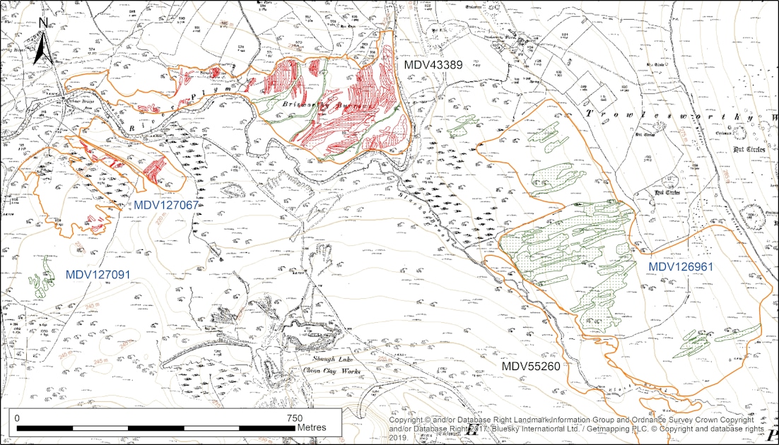
Mapping from lidar data and 1940s RAF aerial photographs has enhanced understanding of tin streaming at Crownhill Down, despite extensive previous fieldwork, not least by increasing the known extent by 4 hectares. The early stages of transition to openwork extraction are suggested by possible prospecting pits along the streamworks, perhaps to rework the lode, and the relationship between the streamworks and a number of historic leats indicates that some water channels pre-dated the streamworks.
Off the higher ground a number of newly identified and extensive streamworks were recorded from lidar. Some of these remains were in areas of former woodland, for example at Sparkwell. The value of the land here presumably made felling and reclamation more worthwhile than in the uplands where tree cover on former industrial sites seems to have persisted.
The possibility of peat fuel being used for the tin industry is raised by the identification of a large area of peat cuttings at Trowlesworthy Common, close to streamworks and the possible site of Brisworthy Tin Mill.
Further leats supplying the various modern china clay works around the Dartmoor fringes were visible as earthworks. Their complexity is clear from the transcriptions, and reflect incremental phases of expansion, though some may have been repurposed from earlier uses. Many of these have since been destroyed or subsumed by 20th and 21st century extraction, along with earlier archaeological remains, including for example the enclosed hut circle settlement at Shaugh Moor.
Leats with a different purpose – civic water supply – can also be traced for many miles across the survey area, and considerable lengths have been mapped from aerial photographs and lidar. These include the late 18th/early 19th century Devonport Leat and the late 16th century Plymouth Leat.
The latter is also known as Drake’s Leat because of the integral part that Sir Francis Drake played in its construction; according to Hawkins (1987, 7) this interest in local infrastructure followed a fall from favour in Elizabeth I’s court caused by an unsuccessful voyage to Lisbon.
Modern conflict landscapes
Aerial survey projects often record considerable evidence of Second World War military activity, stemming from the comprehensive aerial photography carried out in the immediate post-war period. This project also recorded some pre-Second World War defensive sites. Most of these are at Staddon Heights, a focus for military defences protecting Plymouth and the Royal Naval Dockyards since the later 16th century. They include some of ‘Palmerston’s Follies’, late 19th century batteries intended to repel a French invasion but which were never used and have taken on the name of the prime minister of the time.
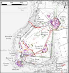

In addition to the well-studied and imposing 18th and 19th century fortifications, the survey was able to record evidence of more ephemeral activity around the buildings. These include the earthworks of probable 19th century practice trenches adjacent to Staddon Fort, in a plot marked as ‘Field for Field Works’ on the 1896 OS map, and cropmarks that are thought likely to have formed over the buried remains of similar features next to Rifle Butts Wall.
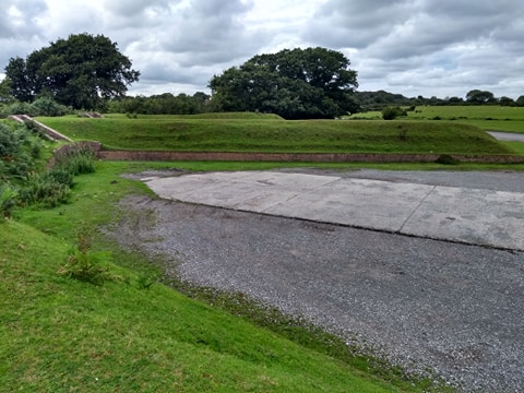
Many of these structures were refortified in the Second World War, and additional contemporary features were visible on the mid-20th century aerial photographs. These included shelters or practice trenches, a possible radar station, an additional barrage balloon site and temporary camps.
Numerous military camps outside of the Staddon area were also recorded on the HER for the first time (for example in the gardens of Hemerdon House or at Kerries Road, South Brent), changing perceptions of how militarised the survey area had been during the conflict, perhaps due to D-Day preparations and aftermath.
Previously recorded sites were enhanced and detail added to bombing decoys, an unusual (for Devon) Z anti-aircraft battery, and the airfields of RAF Harrowbeer and RAF Bolt Head. The substantial earthworks and low structural remains of RAF Harrowbeer still cover an extensive area of access land on Roborough Down, although most of the superstructures had been removed by 1951. Operational between 1941 and 1945, this airfield was constructed using rubble from the Plymouth Blitz (Wasley 1994, 90) and has several claims to fame: Major Glenn Miller and band flew into RAF Harrowbeer on the way to Plymouth for a series of concerts on the 28 August 1944 (Wasley 1994, 172), and fog caused President Truman to be diverted here on the way back from the Potsdam conference on the 2nd August 1945. Additional elements that could be recorded from the aerial photographs include the sick quarters just south-west of the perimeter, visible as a complex of structures, huts and at least one blast shelter, whose purpose was established with the help of the RAF Harrowbeer archive plan of the site.
Further Reading
The results of the surveys will be found in the project highlight report, which will be accessible and downloadable from the Historic England website.
Information on other NMP projects in Devon is also available.
Gallant, L, Luxton, N, & Collman, M. 1986 ‘Ancient Fields on the South Devon Limestone Plateau’. Proceedings of the Devon Archaeological Society 43, 1985: 23-37
Gerrard, S. 2000 The Early British Tin Industry. Stroud: Tempus
Griffith, F. 1988 Devon’s Past, an Aerial View. Exeter: Devon Books
Hawkins, D. J. 1987 Water from the Moor: Illustrated History of the Plymouth, Stonehouse and Devonport Leats. Exeter: Devon Books
Hegarty, C, Knight, S, and Sims, R. 2014 Rapid Coastal Zone Assessment Survey for South-West England – South Coast Devon: Component One National Mapping Programme. AC Archaeology Document Number ACD618/2/1
Hegarty, C, Knight, S, and Sims, R. Forthcoming The South Devon Coast to Dartmoor Aerial Investigation and Mapping Survey Area 1, Haldon Ridge to Dart Valley. Historic England Research Department Report
Historic England 2015 Using Aerial Photographs
Newman, P. 1998 The Dartmoor Tin Industry A Field Guide. Newton Abbot: Chercombe Press
Silvester, R J. 1980 ‘The Prehistoric Open Settlement at Dainton, South Devon’. Proceedings of the Devon Archaeological Society 38, 17-48
Wasley, G D 1994 Devon at War. Exeter: Devon Books
Wilson, D. 1982. Air Photo Interpretation for Archaeologists. London: Batsford.
Your comments
Would you like to share additional information on any of the sites we recorded from aerial photographs, or do you have a different interpretation? Let us know! We read all submissions but unfortunately due to the volume of responses we are unable to respond personally to every comment.