Contents
Annex 10
Back to Main Menu Continue to Annex 11
1. Introduction
The Public Rights of Way and Country Parks service (PRoW & CP service) provide the lead for Devon County Council (the Council) on management and maintenance of the public rights of way network, off-road shared use trails (including cycleways), and unsurfaced unclassified county roads (uUCRs maintenance category 12). The PRoW & CP service is also responsible for management and maintenance Stover Country Park and the Grand Western Canal Country Park, and associated sites including Denbury Camp, White Cross and Knapp Copse.
The table in figure 10.1 (below) summarises the range of functions delivered through the PRoW & CP service. Country Park / Local Nature Reserve functions are subject to separate management plans, and so do not form a direct part of this plan.
With regards to Public Rights of Way, this part of the service (PRoW team), is responsible for management and maintenance of approximately 5,000km of public rights of way, 560km of uUCRs, and 225km of off-road recreational trails (such as the Exe Estuary Trail, the Granite Way and Tarka Trail). The network also includes Devon sections of 2 National Trails (the South West Coast Path and England Coast Path), and Access Land (for example access on foot to moors, heaths, downs, commons and some coastal areas).
To summarise, the PRoW team:
- maintains and keeps under review the legal record of public access rights and status for public rights of way (the Definitive Map and Statement),
- inspects the network, arranges maintenance and co-ordinates improvement works,
- liaises with landowners, including undertaking enforcement action where necessary,
- co-ordinates path diversions, creations and extinguishments and temporary closures on the network,
- manages the Parish Paths Partnership (P3) Scheme, supporting volunteers from Parish and Town Councils to undertake path surveys and carry out smaller scale maintenance and improvement tasks,
- is responsible for the statutory Devon Countryside Access Forum, and
- is responsible for day-to-day management and maintenance of Devon sections of the South West Coast Path National Trail / England Coast Path, and promoted regional routes such as the Two Moors Way.
Priorities are guided and informed by the Rights of Way Improvement Plan (RoWIP). In accordance with the Countryside and Rights of Way Act 2000, the current 10 year RoWIP is currently under review, with a report due to be published in early 2023 (ref. Rights of Way Improvement Plan and policy – Public Rights of Way (devon.gov.uk)).
The RoWIP fits well with the Devon Strategic Plan – Best Place, and action to be fairer, healthier, caring, greener, and prosperous. Public Rights of Way form an important part of highway network activity. At the strategic level, this is of vital importance to:
- connecting people and places (including Active Travel),
- the local economy (with the network providing essential infrastructure in support of recreation, leisure, and tourism),
- carbon reduction, biodiversity, landscape, and heritage (particularly provision for non-car based travel, contribution to climate change avoidance and mitigation measures, and as a key component of green infrastructure), and
- physical and mental health and wellbeing (with benefits directly attributable to exercising outdoors and contact with nature).
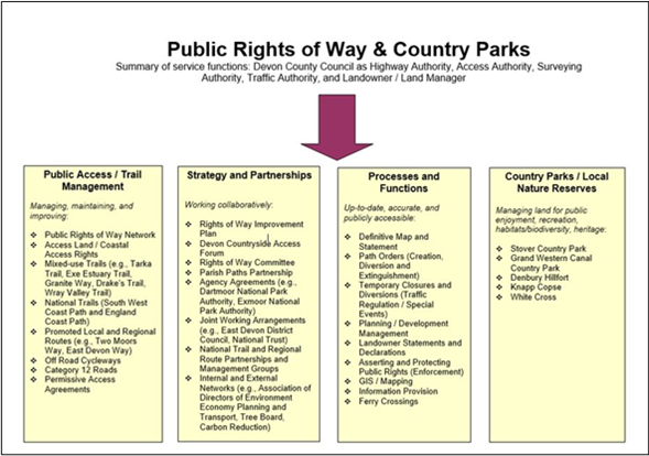
Fig. 10.1: Table showing functions delivered by PRoW and CP service.
2. Inventory
Public Rights of Way (PRoW) are ways over which the public have a right to pass and repass. These are highways maintainable at public expense (ref. What are public rights of way? – Public Rights of Way (devon.gov.uk)), and so subject to similar legislation as vehicular highways – including the Highways Act 1980.
The PRoW network in Devon comprises:
- 3,686 km Public Footpaths – for walking, running, mobility scooters or powered wheelchairs,
- 1,218 km Public Bridleways – for walking, horse riding, bicycles, mobility scooters or powered wheelchairs,
- 33 km Restricted Byways – for any transport without a motor and mobility scooters or powered wheelchairs, and
- 80 km Byways Open to All Traffic – for any kind of transport, including cars (but they’re mainly used by walkers, cyclists, and horse riders).
N.B., using Defra definitions as published at Rights of way and accessing land: Use public rights of way – GOV.UK (www.gov.uk). The network lengths are for Devon, including Dartmoor and Exmoor National Parks, but excluding Plymouth and Torbay as the unitary authorities are responsible for their respective networks.
In addition to the above, the PRoW team is also responsible for:
- Permissive Paths involving formal agreements between a landowner and the Council. Exact length is not published but comprises an additional (approximate) 45 km,
- Off-road recreational trails (including cycleways) include routes such as the Granite Way, Exe Estuary Trail and Tarka Trail, often also forming part of the National Cycle Network (NCN). The PRoW team is responsible for more than 225 km of such trails,
- Maintenance Category 12 (MC12) roads comprise of 588 km of, typically, unbound road. These are generally unmetalled roads not normally used by vehicular traffic, but with value and importance for recreation and leisure use,
- Access land where public rights exist for walking, running, watching wildlife and climbing. Access land includes mountains, moors, heaths and downs that are privately owned. It also includes common land registered with the local council; and (once legal processes are complete) will include Coastal Margin designated through the England Coast Path (ref. Rights of way and accessing land: Use your right to roam – GOV.UK (www.gov.uk)).
This network is growing with new paths and trails being created – for example to meet recreational and active travel needs and to mitigate impacts from development.
The Council, as Highway Authority and Access Authority, is responsible for maintenance and enforcement of the PRoW Network, and for public rights associated with access land. Some maintenance responsibilities are vested with the landowner (for example, the responsibility to keep paths clear of overgrowth, to maintain furniture such as gates and stiles in a safe condition); and some maintenance responsibilities rest with the Council (for example, keeping paths clear of up growth and maintaining the surface in a safe condition).
Alongside maintenance duties, the Council is also responsible for asserting and protecting the rights of the public, including preventing (so far as possible) the stopping up or obstruction of public paths (e.g., as set out through s 130 of the Highways Act 1980).
The Council, as Surveying Authority, is responsible for maintaining the Definitive Map and Statement (being the legal record of PRoWs) and keeping this under continuous review.
The data in figure 10.2 (below) is based on a full inventory of the PRoW network undertaken between 2005 and 2007. This baseline was collated as a GIS layer but has not been systematically or routinely updated and so is in need of review.
PROW Inventory 2005/07
| Bridges | Stiles | |||
|---|---|---|---|---|
| Foot bridge | 1,107 | Ladder stile | 296 | |
| Culvert | 227 | One step stile | 1,846 | |
| Vehicular bridge | 141 | Two step stile | 3,338 | |
| Constructed ford | 32 | Dog stile | 47 | |
| Stepping stones | 23 | Stone stile | 113 | |
| Bridle bridge | 19 | Metal stile | 7 | |
| Unassigned type | 264 | Other | 293 | |
| Total | 1,813 | Total | 5,940 | |
| Fingerposts | 9,054 | Other structures | ||
| Waymarker posts | 13,171 | Steps | 1,243 | |
| Waypost | 2,297 | Boardwalk | 155 | |
| Handrails | 168 | |||
| Gates | Revetment | 113 | ||
| Field gate | 6,132 | Safety barrier | 107 | |
| Pedestrian gate | 915 | Level crossing | 28 | |
| Wooden gate | 1,090 | Unassigned type | 89 | |
| Bridle gate | 365 |
Fig. 10.2: Table showing PRoW inventory.
An estimated valuation of the baseline inventory was previously calculated for the 2005 – 07 data using a model developed by Kent County Council. At that time, the indicative replacement value for the furniture on the network such as stiles, various types of gates, other structures (gaps, rails, boardwalks, revetments etc.), fingerposts, waymark posts, sleeper Bridges, footpath bridges and bridleway bridges was £10,353,794.
3. Performance
3.1 Data collection techniques
The PRoW Team currently includes 10 Wardens (9.8 FTE’s), reporting to a senior PRoW officer, to manage and maintain the network. Each Warden is responsible for the inspection, maintenance, enforcement and improvement of the assets within their area, as outlined on the Council’s website at Warden Areas.
The County Council has Agency Agreements with Dartmoor and Exmoor National Park Authorities (NPAs). The NPAs are responsible for the inspection, maintenance, and enforcement of PROWs within their areas; however, MC12 roads, metalled surfaced paths, and the off-road recreational trails remain with the Council.
The Council also proactively works with parish and town councils (and other community based groups) through the Parish Paths Partnership (P3) – as outlined at Parish Paths Partnership scheme – Public Rights of Way (devon.gov.uk)
PROW Warden Inspections are based on a Warden inspecting each route in their area on the following frequency:
- PROWs and MC12 roads inspected on a three year cycle,
- Off road recreational trails inspected annually, and
- Sections of National Trails inspected annually.
In addition, specialist inspections are carried out by appropriately qualified Council or external staff to assess condition of more significant structural features such as bridges.
PRoW warden inspections are supplemented by user/public reports via Online Reporting, feedback from local volunteers (as part of the P3 scheme), and volunteers from interest groups such as the Ramblers, Sustrans, British Horse Society, Two Moors Way Association, and South West Coast Path Association.
The condition of the network is assessed by Wardens in accordance with guidance set out at PRoW and MC12 roads Condition Criteria. This identifies standards that should be achieved.
PROW Wardens use paper copies of maps and note any comments upon them whilst inspecting. An electronic inspection spreadsheet is set up for each Warden to record details of their inspections (such as date of inspection, problems found, length of path passing at inspection, works required and date works completed). Detail about the condition of every piece of path furniture is not currently required to be collected.
Whilst the current methodology is reasonably effective, it could be beneficial to move to an electronic system. In addition to providing clearer, comparable data, this would allow for regular updates to the inventory. Options will be assessed, with subsequent system changes subject to resource implications and associated requirements.
PRoWs are normally inspected on foot. Off-road recreational trails may be inspected by bicycle. MC12 roads can be inspected on foot, bicycle or in suitable vehicle.
The PRoW Warden Inspection Spreadsheets are set up to enable an ‘ease of use’ percentage to be generated for the County (excluding the NPAs which report on their own ‘ease of use’ figure annually).
Ease of Use is a well-established term from the former Best Value Performance Indicator (BVPI) 178. Ease of use under BVPI178 was defined as “the percentage of the total length of [PROW] which is easy to use by members of the public”. A PROW was regarded as easy to use if it was:
- signposted or waymarked where it leaves a road and to the extent necessary to allow users to follow the PRoW,
- free from unlawful obstructions and other interferences to the public’s right of passage (including overhanging vegetation), and
- with surface and lawful barriers (e.g., stiles and gates) in good repair and to a standard necessary to enable the public to use the way without undue inconvenience.
Other relevant criteria are also factored where applicable – for example the British Standard for Gaps, Gates and Stiles BS 5709 (2006 and 2018 editions), and National Trail Quality Standards, developed by Natural England (ref. National Trails: management standards – GOV.UK (www.gov.uk)).
3.2 Ease of use summary scores
Ease of Use (% Score)
| Year | 2017 | 2018 | 2019 | 2020 | 2021 |
| Public Rights of Way | 96.6 | 97.5 | 97.9 | 97.9 | 96.2 |
| Category 12 Roads | 93.4 | 96.0 | 96.9 | 96.3 | 95.2 |
Fig. 10.3: The tables show the data collected by Wardens
4. Maintenance Strategy
The information set out below outlines the key factors in determining levels of service.
The previous HIAMP closely related to the Devon Strategic Plan, with priorities linked to the headings of Safe, Connected, Healthy, Prosperous, Resilient, and Sustainable. This continues to be directly applicable, with priorities in the current Strategic Plan identifying:
Responding to the climate emergency, especially:
- More opportunities for cycling and walking and horse riding,
- Helping wildlife and landscapes to recover,
- Encourage sustainable lifestyles, and
- Continue to reduce carbon emissions across all our services.
Supporting recovery and growth, especially:
- Secure investment in transport infrastructure, and
- Maintain, and where necessary, improve our highway network and improve sustainable transport options
Tackling poverty and inequality, especially:
- Promote community cohesion.
Improve health and wellbeing, especially:
- Give people greater opportunities for walking and cycling and horse riding to increase their physical activity.
Supporting people and communities, especially:
- Continue to support our vibrant community and voluntary sector,
- Enable a range of transport options, including public transport, and
- Engage directly with people in meaningful ways and encourage participation in decisions that affect them.
Management and maintenance priorities reflect, and support delivery of the objectives highlighted above, with onus on providing a network which is safe, reliable, and fit for purpose (within any necessary funding and resource constraints). This takes into consideration of current statutory duties and maintenance regimes, as well as the responsibilities of landowners.
A key reference is the Rights of Way Improvement Plan, with priorities developed and reviewed in liaison with stakeholders, including through the Devon Countryside Access Forum.
The Highways Act 1980 identifies certain landowner responsibilities for the provision and maintenance of path furniture such as gates and stiles; and a landowner can potentially claim at least 25% of the cost of replacement from the County Council. Information on this is outlined on GOV.UK at Public rights of way: landowner responsibilities – GOV.UK (www.gov.uk).
The PRoW Team will generally co-ordinate provision of path furniture in lieu of payment. This ensures that the furniture, and its installation, meets the British Standard for Gaps, Gates and Stiles (BS5709:2006 or 2018) and can avoid the need to take costly and time-consuming enforcement action against a landowner to secure removal of inappropriate structures.
In accordance with good practice (and as per the RoWIP), the PRoW Team no longer supplies stile kits to landowners. Accessible gates, or preferably gaps, provide a far more inclusive measure enabling improved opportunities for people with restricted mobility. However, current legislation does not allow for the Council to insist that an existing stile is replaced with a gap or gate.
- The County Council has a duty to install a signpost where a PRoW leaves a metalled highway,
- The County Council has a power to provide waymarking along a PRoW in consultation with a landowner,
Bridge maintenance is normally the responsibility of the County Council. Exceptions may exist where, for example, a PROW follows a private track and makes use of a privately maintainable vehicular bridge. The PRoW Team directly inspects some bridges and structures for example where there is a clear span of less than 6 metres and culverts and masonry structures with a diameter of less than 1.5 metres. Inspections are on a minimum of a three-year cycle.
EDG undertakes Principal Inspections of the larger bridges and structures as outlined in Annex 11 – Structures.
- The PRoW Team delivers on the County Council’s powers to divert, create and extinguish PRoWs in the interest of landowners and / or the public. New legislation resulting from the Deregulation Act will change this power to a duty, with landowners then having a right to apply for changes to the network and for the Council to determine the application within certain timescales,
- The PRoW Team manages / processes Road Traffic Regulation Act 1984 temporary closures of the PRoW network, and
- Policies and Actions for the management and maintenance of the PRoW network are set out in the statutory Rights of Way Improvement Plan 2012. This 10-year plan is currently under review.
4.1 South West Coast Path National Trail and England Coast Path
The PRoW team is responsible for the public rights of way and other paths that make up these National Trails where they cross Devon (with the exception of sections managed by Exmoor National Park Authority)
Natural England currently funds up to a maximum of 75% of the maintenance of National Trails and allocates grants on an annual basis. A formal agreement sets out higher condition requirements against an agreed funding formula. Devon sections are made up of 145 kilometres in north Devon and 185 kilometres in south Devon.
The route(s) passes through numerous towns including (north Devon) Lynmouth, Lynton, Ilfracombe, Barnstaple, Bideford; (south Devon) Plymouth, Salcombe, Dartmouth, Brixham, Paignton, Torquay, Teignmouth, Dawlish, Exmouth, Sidmouth, Seaton.
The route(s) also passes through nationally renowned coastal landscapes; cliffs, sandy bays, wooded estuaries, historic harbours.
Walking varies between easy and strenuous, depending on location.
The Path coincides with a number of regional routes including the Tarka Trail (The Tarka Trail – Welcome to The Tarka Trail), the East Devon Way (East Devon Way – Explore Devon), the Two Moors Way (Two Moors Way – Devon’s Coast To Coast), and the Exe Estuary Trail (Exploring the Exe | Exe Estuary Management Partnership (exe-estuary.org)).
4.2 Permissive Paths
- Each path may have unique maintenance requirements depending on the respective legal agreement; but generally, the liability for maintenance will fall to the County Council, and
- A scanned copy of each agreement is stored by the PRoW Team and details of each route are mapped on to GIS.
4.3 Off-road recreational trails
- The exact extent of this asset is not yet fully digitised. The PRoW Team took responsibility for such trails in 2010 but without an accurate record of the asset. A programme has been put in place which seeks to pull together the County Council’s legal agreements, leases, title deeds and restrictive covenants for off-road recreational trails. Once this has been completed there will be certainty over precisely which routes the County Council is responsible for and the extent of maintenance liabilities for each section of each route, and
- The majority of such trails are not highway but are managed in a similar way to PRoW. As such, the paths are generally not covered by highways legislation. Maintenance liability for every section of trail will vary depending on what was agreed when the trail was established. This information may be contained in the legal agreements, leases, title deeds, covenants etc. The County Council’s liability may extend, for example, to maintenance of the path surface, bridges, boardwalks, adjacent fencing, vegetation (upgrowth and overgrowth), path furniture (gates), benches, art installations, verge cutting, drainage and ditches and signage.
- Currently some leases, licences and structures do not include equestrian use. This issue has been identified by the Devon Countryside Access Forum as an improvement need, with guidance on new schemes highlighting the importance of providing for equestrian use.
4.4 Maintenance Category 12 (MC12) Roads
MC12 Roads are simply vehicular highways that happen, for whatever reason, to have remained or have become unsurfaced and which do not serve property. Often, they are ‘green lanes’ with a hedge to each side, sometimes with an unsealed stone surface or a completely natural surface. Priority is given to:
- routes that form part of the regional route network, e.g. Two Moors Way,
- routes that provide access to a public right of way,
- routes that provide the only off-road access in a parish, and
- routes that provide links to villages, schools, health providers etc.
Through the ‘Changing Lanes’ process, some formerly-sealed roads are being re-categorised as MC 12 roads and so the County Council will have to manage their deterioration in a safe manner. Regardless of their condition, they are highways coming under the full auspices of the Highways Act 1980.
4.5 Parish Paths Partnership (P3)
The Parish Paths Partnerships Scheme is an initiative that encourages communities to look after the maintenance of their rights of way network. It has the support of the National Association of Local Councils and is Council funded. The Highway Authority works in partnership with Parish/Town Councils, landowners, and local voluntary groups to improve the condition of the local rights of way and keep them open and used. 167 parish councils participate to date.
Parish/Town Councils in the scheme receive a grant from the Council based on their mileage of paths. All P3 groups undertake an annual survey of the local network of paths and, from this, projects are planned and completed. The following web pages provides the details of the P3 scheme: https://www.devon.gov.uk/prow/parish-paths-partnership-scheme/.
5. Levels of Service and Investment Strategy
As set out above, service levels are guided by the Public Rights of Way Condition Criteria, and relevant national guidance including National Trail Quality Standards and British Standards. The RoWIP is also a key tool.
Subsequent work plan priorities are largely identified through inspection regimes, and also through community consultation through the Parish Paths Partnership scheme.
In addition to the identified improvement action to update the asset inventory, it is proposed that management plans be drafted for higher profile trails and cycle routes.
The table below summarises likely impacts should funding constraints require a reduction in service delivery;
| Cost Cutting Measures | Impact on Service |
|---|---|
| Reduction in ‘ease of use’ from current 90 +% to 80%
Reduction in major bridge replacement No enhanced maintenance of the National Trail or Regional routes Reactive vegetation cutting only Reduction of P3 grants and number of parishes participating in the scheme Termination of National Park agency agreements and East Devon District Council arrangement for the coast path Reduced maintenance of cycle/ multi use trail network and MC12 network closures
| Serious impact on the Council’s reputation with increase in complaints from users and staff /money resource in dealing with subsequent issues.
Significant impact on tourism reliant on good quality path network. (National and Regional routes are of major value to Devon’s reputation as a holiday destination). Impact on national agendas such as Active Travel Strategy and Health & Wellbeing targets Loss of good working relationships with other Agencies and parish councils Potential claims from accidents arising from safety defects. Decline in safe off road cycle and horse-riding routes Decline in the Council’s policy of encouraging path use by less able members of the community Increased costs from reactive maintenance resulting in Sect 56 HA action against the Council
|
Fig. 10.4: Likely impacts of reduction in service delivery
6. Programme Development
Annual improvement / capital programmes are put together based on need and deliverability; this being considered in accordance with objectives set out within the RoWIP.
Unlike road improvements, generally a PROW improvement will require substantial landowner liaison (for example, to negotiate issues such as access to the site with machinery, keeping worksites stock-proof and timing of works to minimise damage to neighbouring land).
Improvements to the cycle route / trail network can be more easily programmed where Devon County Council is also the landowner or land manager.
Works programmes are currently annual.
7. Risks
Risk management is most relevant with regards to climate change, local economy, health and well-being, and public safety:
- The county council has recognised the necessity of managing the network to reflect increased frequency of and damage to the network through severe weather events. This includes issues such as flooding, erosion, and high winds.
- The economic drivers – The importance of the Public Rights of Way Network (PRoW) to the local economy as demonstrated by the £157m direct spend by users of the South West Coast Path during 2012 and by the closure of the PRoW network during the Foot and Mouth crisis in 2001 which is estimated to have cost Devon’s economy more than £400 million.
- Health and wellbeing strategies – There is clear evidence that well maintained, easy to use public rights of way encourage people to use them. In contrast, poorly maintained, damaged or closed routes discourage use and therefore discourage exercise and engagement with the natural environment. There is also clear and growing evidence demonstrating that an increase in exercise leads to a decrease in physical and mental health problems, with associated decreased burden on the NHS and public purse. For example, inactivity in England is estimated to cost the NHS an additional 1.06 billion each year and problems relating to overweight, and obesity cost an additional 5 billion each year.
- Meeting inspection frequencies – Appropriate inspection regimes, in combination with effective maintenance works are essential in meeting relevant statutory requirements, ensuring public safety, and minimising claims against Devon County Council for damages and personal injuries.
- Financial resilience / resources – Financial constraints and growth in the length of the network to be maintained create pressures in meeting and sustaining quality standards. This potentially impacts across all the risks outlined above.
8. Improvement Actions
Alongside the Highway Infrastructure Asset Management Plan, this Annex is a live document. It will be subject to continuous improvement and ongoing development with input from Council Officers and Stakeholder feedback. Areas for improvement are identified within the Annex which are summarised as Improvement Actions in this section. These Actions are aligned with Strategic Goals and are assessed as part of a wider cross-asset prioritisation process that prioritises their implementation taking account of the framework of funding and resource availability.
The actions that have been identified as being required to ensure the Public Rights of Way asset management objectives are achieved are:
- Review and update the PRoW inventory and associated GIS layer,
- Identify software and hardware options to support inspections and condition assessments, and to keep the inventory up to date,
- Review and update records to clearly identify the extent of permissive agreements and legal status of recreational trails. This includes leases, licences, and Devon County Council ownership. Utilise this data to inform trail specific management and maintenance plans,
- Improve functionality, accuracy, and response times for user reports,
- Review and where practicable, adjust seasonal vegetation cuts to further enhance biodiversity,
- Investigate materials and construction techniques for surface and drainage works to minimise carbon whilst optimising ease of use and environmental impact,
- Continuing work to address / remove physical obstacles to improve equity of access, and
- Prioritise path orders to facilitate diversions and creations to improve accessibility, enjoyment and land management.
Useful References
- Outdoor access and recreation: Access and rights of way – detailed information – GOV.UK (www.gov.uk)
- Public rights of way local authority responsibilities – GOV.UK (www.gov.uk)
- Rights of way circular (1/09) – GOV.UK (www.gov.uk)
- Definitive maps of public rights of way: change the legal records – GOV.UK (www.gov.uk)
- The Natural Choice: securing the value of nature CM 8082 (publishing.service.gov.uk)
- Devon Local Nature Partnership (devonlnp.org.uk)
- Access – Devon Local Nature Partnership (devonlnp.org.uk)
- State of Environment report – Devon Local Nature Partnership (devonlnp.org.uk)
- Explore Devon’s environment, wildlife and heritage – Explore Devon
- New guidance on shared use routes | Cycling UK
- Share, respect and enjoy the National Cycle Network – Sustrans.org.uk
- Leaflets and downloads | The British Horse Society (bhs.org.uk)
Version Control
| Version | Date | Summary of Changes |
|---|---|---|
| 1.0 | 12 April 2023 |