Scope of data collected
The collision data that we routinely use and present in our dashboards is called Stats19 data; it’s road casualty data collected by the police. The collection and recording process is governed by the Department for Transport (DfT).
Full guidance at GOV.UK – Road accidents and safety statistics guidance. In summary the DfT stipulate that Stats19 collision data should only consist of collisions that were recorded by the police, occurred on a public highway, involved human death or personal injury, involved one or more vehicles and were notified to the police within 30 days of occurrence.
Injury severity
The data only includes collisions where an injury occurred. Examples of slight injury include: sprains, neck whiplash injury, bruises, slight cuts, slight shock requiring roadside attention. Serious injury examples include any type of fracture, internal injury, severe cuts, crushing, burns, concussion, severe shock, hospital in-patient. Please note that the Department for Transport (DFT) Stats19 recording rules state that if a road casualty died more than 30 days after the collision their injury should be recorded as serious. Also note that anyone who died because of a confirmed medical episode or confirmed as suicide are not included in this Stats19 dataset.
Data accuracy and validation of collision records
- Adjusted Injury Data. In December 2015 serious injury casualties started to be recorded more accurately due to a change in the reporting system used by the Police called CRASH. Some serious injuries may previously have been classified as slight injuries which means that the 2016 data and earlier will show a lower number of serious casualties than after 2016. Currently our reports usually show unadjusted figures by default. The Department for Transport have researched a method to back calculate the statistical probability of a record injury severity being miscoded, but this method is currently too sensitive to use in small numbers, so any projected adjustments are shown for the whole of Devon across all road users.
- Validation. We conduct our own accuracy and validation checks on this data after we have received it from the police. The data must be checked and fully validated by the DfT before it can be released – this validation process with the DfT is undertaken annually every spring and is usually complete by the end of May at which point we can then release the data for general use.
- While every reasonable effort is made to ensure that Stats19 information and statistics provided is correct no guarantees for the accuracy of information are made.
Updates to the data
We release collision data a year at a time, usually in May the following year. There is a delay due to a lot of validation work and reconciliation with the Department for Transport who govern the collection of the data.
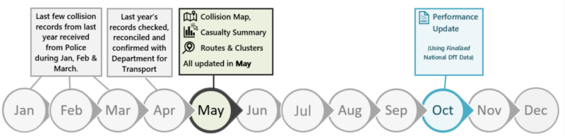
These milestones are interlinked with the Department for Transport (DfT) timelines; it takes up to April/May time to fully collect, check and validate the data with the DfT. Our maps and dashboards are then updated around May time.
High Harm Routes
We have worked with the Vision Zero South West Road Safety Partnership to analyse and compare collisions on the A and B road network across the whole Devon & Cornwall Police force area in order to identify the best and worst performing roads based on collision density. We use the following route methodology:
The number of collisions > times by a severity multiplier value* > divided by the route length
* Severity Multiplier is 7.1 for fatal and 4.5 for serious. See section on this age on Severity Multiplier for more info.
The scores for each route are ordered from worst to best and then divided up into five equal quintiles, 1 Worst, 2 Poor, 3 Average, 4 Better, 5 Best.
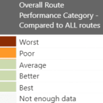
When the results are displayed on a map we colour the quintiles using Red Amber Colours. ‘Worst’ performing are coloured red. ‘Poor’ are amber. The remaining three quintiles Average/Middle, Better and Best are coloured green. Note we also have ‘Grey Routes’. Grey routes aren’t scored and ranked due to low numbers combined with a short length; route length less than 540 meters and collision score less than 9.
How will we track route performance over future years? When each new year’s data is published, we will recalculate the route score to see where they fall within the 5 quintile ranges set using 2016-2020 data. We will be tracking the route score to see if it is better or worse than the previous 5-year stats.
What specifications were used to define where a route segment starts and ends?
- Start/stop the route segment where A and B roads meet.
- Start/stop 50 m away from the junction at the ends of the route. (Junctions are covered separately in cluster analysis)
- Start/stop where the road environment changes from urban to rural for at least 1 kilometre. This rationale uses the speed limit to define urban/rural e.g. change from 60 to 40 or 30.
- Any short links than 200 m to be excluded as collision numbers would be too small to capture a meaningful result.
- For any unusual routes that do not fit the above rationale, e.g. one way circular routes don’t have an obvious start/stop point, then with consensus from other colleagues draw a best fit route (this was rare and occurred in less than 1% of the routes)
Cluster sites
Our cluster site (blackspot) minimum criteria is:
5 or more injury collisions occurring up to a 50 metre radius, over a 5 year period
Typically these criteria identifies around 70 potential cluster sites across the Devon County Council road network. Each of the sites are reviewed by our Safer Travel Programme Officer to confirm which ones qualify for further investigation. Any sites that are discounted from further investigation are usually due to the following reasons:
- If sites are previous, pending, current or other cluster site review schemes.
- If a site is already identified through another cluster parameters.
- Wrongly or poorly located records reducing clusters below minimum criteria.
- Eliminating output where the polygon captures multiple roads.
- Recent years zero spurious collision records e.g. medical episode contributing to collision numbers.
- Highways England roads.
What happens to the sites that are put forward for further investigation? We check the collisions within the qualifying sites have a genuine link with potential road surface issues. This manual verification process involves reading through the Police officers account of what happened for every collision and other information available.
What Happens Next? A capital funded solution is not always sought and undertaken. Once a site is fully investigated, if appropriate, a viable solution is sought and a preliminary cost for the solution is calculated. If no solution can be identified these schemes should be re-investigated by a different trained team.
Severity Multiplier
We use a multiplier of 7.1 for fatal collisions and 4.5 for serious injury collisions when scoring and ranking our High Harm Routes and Cluster sites.
We calculated this multiplier using the DFT prevention of collision costs – specifically the medical and ambulance, Police, insurance and admin and damage to property costs only. The human cost and lost output cost elements have not been included which leaves just the ‘structural’ costs in the equation. The values that remain more closely reflects the impact of collisions on network operators as opposed to the general cost to society.
See Department for Transport RAS4001: Average and total value of prevention of collisions (ODS, 43.2 KB). The total prevention values by severity are in sheet ‘Average_Value’. With human cost and lost output included the ratio is 82.4 fatal or 9.5 serious to 1 slight. However with lost output and human costs removed (the figures and proportions of all the cost elements can be seen in sheet ‘Total_value’) the ratio becomes 7.1 for a fatal, and 4.5 for serious to 1 slight.
We originally calculated these ratios using 2016 values, the latest 2021 ratios have not changed significantly.
Statistical tests
Poisson Distribution. ROSPA (Royal Society for Prevention of Accidents) guidelines for using statistical probability within road safety accident investigation context suggests the Poisson distribution is used when identifying the possibility of an annual change being down to random fluctuation. Calculations look at the probability of the latest year being significantly different from the current ten-year average (the ten years include the latest year).
We use this test in various data tables and illustrate any significant results using flag icons.
- A red flag indicates a significant increase in the latest year compared to the ten-year average. The confidence value is higher than 95%.
- An amber flag represents borderline significant increase equating to a confidence value between 85-94%.
- A green flag represents a significant decrease in the latest year.
Chi Square Value. This can be used to compare data with a control set to determine if the difference between the control is significant. Often used where percentages are analysed, for example, darkness percentage or single vehicle percentage.
Geography-related definitions
The geographic coverage in our data outputs and reports relate to Devon County Council only. Plymouth and Torbay collisions are not collected by Devon County Council as they form their own unitary council areas and collect their data separately.
Area figures (districts, towns, parishes). These are statistics that relate to which area the collision occurred in (as opposed to where the person injured lived). Where a boundary map of areas is shown the darker the colour the higher the count of casualties. Note that comparing geographic performance is a complex picture as each area varies in traffic patterns and volumes, distribution of major roads and population. The areas typically shown relate to the Devon County Council area. Torbay and Plymouth are separate Unitary Councils, so we do not routinely collect their data.
Urban or rural classification – LSOA’s (Lower Super Output Areas). Lower Super Output Areas have been used to determine whether the collision occurred on a rural or urban road. Note this is a new method used for 2020 data outputs, previously we used a local generic definition of town areas with 7,000+ population. More information on LSOA: LSOAs, LEPs and lookups : A beginner’s guide to statistical geographies (ocsi.uk)
Casualty Distance From Home. The distance between where the collision occurred, and the home postcode of the person injured. It uses the centre point of the postcode area of the person, this centre point is known as the postcode centroid.
MOSAIC Demographic Profiles. Mosaic is a geodemographic classification of households, essentially it segments households into different types or groups to help understand likely behaviour. The Profiles are compiled by Experian using data collated from several government and commercial sources.
Adjusted data (affects years up to 2016)
In 2016 Devon and Cornwall Police switched to using a new collision record recording system called CRASH. CRASH is an ‘injury-based severity reporting system’ that uses the injury description to determine if a casualty incurred a serious or a slight injury. Studies show that injury severity is better recorded with this type of system. Prior to the system being used we can apply a correction to anticipate the number of serious casualties recorded should an injury based system be used. Typically serious casualties were being recorded as slight in error, so the prediction will show a higher number of serious casualties when display Adjusted pre 2016 data.
The correction has been calculated by Department for Transport and The Office for National Statistics (ONS) Methodology Advisory Service. More information at GOV.UK: Guide to severity adjustments for reported road casualty statistics.
Frequently asked questions
- Why can’t I see any collision data for this year?
Collision data is released a calendar year at a time, around May the following year. This timeline is down to an extensive data checking process that helps to enhance the accuracy of the data. This process takes place once we have fully collected the data, checked for various errors and validated the records in line with data collection rules stipulated by the Department for Transport Stats19/20 guidance.
Finally before the data can be released we also liaise with the DfT directly to ensure our dataset is aligned and validated with what they have recorded for our area. Once fully aligned the data is officially “signed off” with the DfT which completes the process. This usually happens by the end of May every year.
- A collision has occurred at a location but I can’t see it on the map, why is this?
These are the most likely reasons (see question 9 for more details):
- The collision may not have been reported to/recorded by Devon & Cornwall Police.
- The collision may not have resulted in personal injury (or an injury was not logged with the Police at the time of recording).
- The collision may have been inaccurately plotted. Whilst every reasonable effort is made to ensure that the information provided is correct, no guarantees for the accuracy of the information are made.
- Why are damage only collisions excluded?
We follow national guidance set out by the Department for Transport (DfT). They state that only “road accidents involving human death or personal injury occurring on the Highway” are to be reported.
- What are the differences between collisions and casualties?
A collision refers to the incident itself. The incident can involve any number of vehicles and people. This data only includes collisions where a person/people were injured.
Casualties are the people themselves who are injured in the collisions. These numbers can be higher than collision numbers as a single collision can result in more than one casualty.
- I’m sure someone was killed in a collision at a certain location, but it looks like it’s recorded as a ‘serious’ collision. Why would this be?
It might be because death occurred more than 30 days after the collision occurred. If this was the case then the Department for Transport state that the casualty severity should be described as ‘Serious’.
- How do I report a collision showing up on the map in the wrong location?
Please let us know via collisiondata@devon.gov.uk. We are happy to query the collision location with the Police who initially plot the collision locations, and can correct our database independently.
- Is there any reason a collision would not be recorded in your dataset?
The DfT guidance document that relates to completion of road accident reports is called Stats20. Firstly it states that ” All road accidents involving human death or personal injury occurring on the Highway (‘road’ in Scotland) and notified to the police within 30 days of occurrence, and in which one or more vehicles are involved, are to be reported.”
Stats20 – Examples of accidents to be reported include:
- accidents which commence on the highway but which involve casualties off the highway (e.g. where a vehicle
- runs out of control while on the highway and causes casualties elsewhere);
- accidents involving the boarding and alighting of buses or coaches and accidents in which passengers
- already aboard a bus/coach are injured, whether or not another vehicle or a pedestrian is involved;
- accidents to pedal cyclists or horse riders, where they injure themselves or a pedestrian;
- accidents resulting from deliberate acts of violence, but excluding casualties who are subsequently identified as confirmed suicides;
- accidents within bus stations/interchanges where they form part of the highway;
- accidents in Royal Parks (on roads to which the public have motor vehicle access)
Stats20 – Examples of accidents which should not be reported include:
- accidents which do not involve personal injury
- accidents on private roads (except Royal Parks) or in car parks
- accidents reported to the police 30 or more days after they occurred
- accidents involving confirmed suicides only.
- Why do collision numbers differ between the Police and the Council?
We publish Stats19 collision data which is subject to recording guidelines set by the Department for Transport (DFT). The Police may publish figures that include NON Stats19 collisions.
A full list of non Stats19 collisions can be found in DFT guidance document Stats20. Essentially they are collisions that occurred on private land (mainly car parks), casualties that died from a medical episode as opposed to the collision itself and confirmed suicides. The DFT guidelines also state that if death occurred more than 30 days after the collision their injury is recorded as Serious.
Finally we usually publish data using calendars, running from January to December.
- Where can I find more information on what the Police have recorded?
You can contact Devon and Cornwall Police directly for collision related information, for more details please see their website.
- Where can I see collisions recorded outside of the Devon County Council area?
Here is a national collision map available via www.collisionmap.uk.
- Why are some collisions on crashmap.co.uk in a different place on your map?
It’s most likely because it was previously incorrectly plotted and we have since corrected the location, but the national map has not been subsequently updated because they are fed by national DfT data which is locked down once they have signed off with every local authority each year. (For more info on this signing off procedure see Q2).
- Where can I find more details on national statistics?
The Department for Transport (DfT) publish an annual report called ‘Reported road casualties Great Britain’ which is a very detailed document with data tables relating to collisions and resulting casualties.
The report is released every autumn, the latest reports can be found here.
Glossary
| Term | Description |
|---|---|
| AADT | AADT stands for annual average daily traffic. The source of the AADT’s used in this report is the Department for Transport. |
| Average distance from home | Distance from home is a measure built into MAST which is based on a calculation of the distance in kilometres between a crash location and the home address of each person involved. MAST aggregates all the results of this calculation, and expresses them as averages for all individuals included, summarised by dimensions as required. |
| Blameworthy Vehicle | This is based on vehicle record number one in the database. It is general practice to assign vehicle record number one as the blameworthy, but this is the officer’s opinion, and the recording practice is not compulsory, so accuracy cannot be guaranteed. |
| Casualty | Casualty data refers to the people themselves who are injured in a collision. Often more than one person is injured so casualty statistics are usually higher than collision numbers. |
| Child | In this report we have used the DfT definition of a child which is up to and including the age of 15. |
| Collision | This refers to the incident itself. |
| Cycling to/from school | Journeys in which school pupils up to and including 16 years of age are travelling to, or from, school by bicycle. It includes journeys to/from pre-school or after-school activities based at the school but exclude journeys made to/from school activities which are not based at the school itself. Journeys between school and childcare organisation/childminder are included, but journeys between childcare and the pupil’s home are not. |
| Cluster Sites (historically known as accident black spots) | Collision clusters are identified using a five-year history of collision data. As collision numbers are falling over time it is increasingly likely that the starting point minimum criteria will need to be varied accordingly to either search for fewer collisions or a wider geographical radius. The revised and confirmed minimum criteria is decided by the Safer Travel Programme Officer using professional judgement. The next step to verify the sites is even more important when minimum criteria has been lowered; it is more likely that randomly located collisions will be picked up and it will be harder to find true cluster sites with distinct collision patterns. |
| Contributory Factors | Contributory factors are largely subjective and depend on the skill and experience of the investigating officer. Contributory Factors reflect the Reporting Officer’s opinion at the time of reporting and are not necessarily the result of extensive investigation. Furthermore, it is recognised that subsequent enquiries could lead to the reporting officer changing their opinion. More than one factor can be assigned to each collision. Usually, 2-3 are assigned but a maximum of 6 can be recorded. |
| Date Ranges of Collison Data | Collision data is released a calendar year at a time, around June the following year. This timeline is down to an extensive data checking process that helps to enhance the accuracy of the data. This process takes place once we have fully collected the data, checked for various errors and validated the records in line with data collection rules stipulated by the Department for Transport Stats19/20 guidance. Finally, before the data can be released, we also liaise with the DfT directly to ensure our dataset is aligned and validated with what they have recorded for our area. Once fully aligned the data is officially “signed off” with the DfT which completes the process. This usually happens by the end of May every year. |
| Dark Collisions | ‘Darkness’ means half an hour after sunset to half an hour before sunrise. ‘Daylight’ means all other times. |
| Devon CC | Devon County Council |
| Driving Licence Data | The driving licence data refers to 2017 data relating to Devon residents living in all EX postcodes except EX23, the TQ6 to TQ14 postcodes, PL19 to PL21 postcodes and PL8 area. The number of driving licence holders does not necessarily represent the number of active drivers. |
| DFT | Department for Transport, a central government department. |
| Fatal collision | Human casualties who sustained injuries which caused death less than 30 days after the collision. Confirmed suicides are excluded. |
| Five-year average | Five-year averages are taken from the previous five years prior to 2017 (therefore 2012 to 2016). |
| Highways England Roads | We have used custom polygons in a GIS (geographic information system) to determine which collisions were plotted on a Highways England Road/junction. Highways England routes in Devon are M5, A30, A303, A38. |
| HES | Hospital Episode Statistics – HES is a data warehouse containing details of all admissions, outpatient appointments and A&E attendances at NHS hospitals in England. In this report we use the data relating to transport accident hospital admissions. (RD&E, Northern Devon Healthcare Trust and Devon Community Hospital admissions only). |
| KSI | Acronym for Killed or Seriously Injured |
| Major Roads Traffic | A major roads traffic count is in chapter 6 – major roads refer to an average taken from the M5 and the A roads in the Devon County Council area. |
| National Data | National data refers to England, Scotland & Wales, except for where a casualty billion vehicle KM rate is given – in which case this is a rate for just England. |
| Route Analysis | Performance calculations and methodology can be found in ‘High harm routes’ above. |
| School Journey | Vehicle passenger data is based on the related vehicle journey purpose being entered as ‘taking pupil to/from school’. School bus journeys should be included if the bus is travelling to/from a school. It is possible that if it is unknown whether it was a school bus, it may be coded ‘Journey as part of work’ and therefore will be absent from these figures. Journeys to/from pre-school or after-school activities based at the school should be included in these figures, but journeys made to/from school activities which are not based at the school itself should be excluded. Cycling to/from school is a data field within the vehicle journey purpose section. Child walking to/from school figures are based on a casualty data field and as of 2014 this field no longer exists in the Devon & Cornwall Police Stats19 form, so future reporting of this data is uncertain. |
| School Run | School run is coded as taking a pupil to/from school in Stats19. A driver/rider involved in an accident whilst travelling to school to collect a pupil or returning home after having taken a pupil to school, should be coded if this is the only purpose for the journey. The journey purpose in an accident involving a parent travelling to work and taking a child to school should be coded ‘Taking pupil to/from school’. If the child is in or leaving the vehicle when the accident occurs it should be coded ‘Commuting to/from work’ if the accident occurs after the child has alighted from the vehicle. |
| Serious collision | Examples of ‘Serious’ injury are, fracture, internal injury, severe cuts, crushing, burns (excluding friction burns), concussion, severe general shock requiring hospital treatment, detention in hospital as an in-patient, either immediately or later and injuries to casualties who die 30 or more days after the accident from injuries sustained in that accident. |
| Slight injury collision | Examples of ‘Slight’ injury are sprains, not necessarily requiring medical treatment, neck whiplash injury, bruises, slight cuts and slight shock requiring roadside attention. (Persons who are merely shaken and who have no other injury should not be included unless they receive or appear to need medical treatment). |
| South West | This includes Bath and North East Somerset, Bournemouth, City of Bristol, Cornwall, Isles of Scilly, North Somerset, Plymouth, Poole, South Gloucestershire, Swindon, Torbay, Wiltshire, Devon, Dorset, Gloucestershire and Somerset. |
| Statistical Tests | We have used two statistical tests in this report. Their uses in relation to collisions are described by ROSPA: The Poisson test can be used to determine whether the recent increase is likely to persist or whether the increase was due to random fluctuation and therefore the number of collisions at the site will return to previous levels. In other words, the Poisson test is used to calculate the probability of a particular number of collisions occurring at a location in a given year when the long-term average for that location is known. The Chi Squared test can be used to determine whether the number of collisions of a particular type is ‘significantly’ higher than at similar sites. |
| Stats19 Data | The recording system for collisions reported/recorded by the Police. It only includes collisions that occurred on a highway, involved one or more vehicles and human death or personal injury. It only includes collisions that were notified to the Police within 30 days of occurrence. |
| Strategic Framework | The Strategic Framework sets out the package of policies that the Department for Transport believe will continue to reduce deaths and injuries on the road. They are split between national and local priorities. |
| TAG | Transport Analysis Guidance. The data used from TAG refers specifically to data within document Unit 3.4.1 – Table 4a the economic value of prevention of collisions. |
| Urban/Rural Classification | These areas are classified as urban/rural using Lower Super Output Areas (LSOAs) which are a nationally used dataset. |
| VRU’s | Vulnerable Road Users –includes cyclists, motorcyclist and pedestrians. |
| Wet Collisions | This refers to the road surface condition at the time of the accident. ‘Wet/damp’ is the code we use. To get a wet/dry ratio the number of wet collisions is divided between the number of dry collisions. Flood (surface water over 3 cm deep), snow and frost/ice codes are not included in the wet/damp ratio data. |
| Wet/Damp Cluster Sites | Road surface related cluster analysis is conducted on behalf of the Asset Management Team who carry out their own further investigations into the road surface condition at any locations identified. Criteria: 5 collisions in 3 years that included factors listed below that occurred within 200 m and 33% or more of the collisions occurred on wet/damp road surface. Factor code and description: 101 –Poor or defective road surface 102 –Deposit on Road e.g. Oil, mud, chippings etc 103 –Slippery road due to weather 108 –Road layout i.e. bend hill narrow carriageway 110 –Slippery inspection cover or road marking. 307 –Travelling too fast for circumstances 308 –Following too close401–Junction overshoot 409 –Swerved 410 –Loss of control 707 –Rain, sleet, snow or fog Although we have refined the initial selection of collisions, each site that matches the criteria will need to be verified to check if each site’s collisions have a genuine link with potential road surface issues. This manual verification process involves reading through the Police officers account of what happened for every collision and other information available. |
Accessibility
We take accessibility seriously and have incorporated accessibility functionality to our power BI dashboard style reports to allow content to be as accessible as possible. If you find some of the information not accessible, need guidance or an alternative format email collisiondata@devon.gov.uk with details of any preferred format and the assistive technology you use.
Any other questions?
If your query relating to collision data has not been answered here please email us at collisiondata@devon.gov.uk.