Latest Casualty Overview

High Harm Routes
We’ve worked with the Vision Zero South West Partnership to identify High Harm Routes. You can find the results for Devon County Council’s A and B roads on the map dashboard below. Each route segment is color-coded based on its collision performance score. Red routes represent the worst-performing fifth of all A and B road segments across Devon and Cornwall. To view collision statistics for a specific route segment, zoom in on the map and click on the desired route.
The route performance scoring includes a severity weighting for fatal and serious injury collisions. More on route scoring method here.
What We Do With Data
- We fulfil our statutory obligation to investigate collisions as mandated by the Road Safety Act 1988, which requires local highway authorities to implement road safety measures. Our road casualty statistics reports, in a dashboard-style format, are a vital part of our efforts to analyse collision data collected by the Police, uncovering the details of where, when, who, and why accidents occur.
- We gather road casualty data from Devon & Cornwall Police and clean the data according to Department for Transport (DfT) guidelines. More on collection/release of data.
- We create detailed dashboard-style reports that focus on specific road user groups and geographical areas, including councillor area profiles.
- We offer insights into routes and locations with higher collision rates, such as A & B road analysis displayed in the dashboard below. This information is crucial for shaping priorities, both within and outside the Road Safety team, including areas like Transport Planning (for the Local Transport Plan), Highways Maintenance, Highways Development Management, and Public Health.
- We leverage collision data to create evidence-based education programs tailored for different road user groups, including younger and older drivers, motorcyclists, and business drivers. These programs are developed in collaboration with partner agencies within the Vision Zero South West Road Safety Partnership.
Partners in the Vision Zero South West Partnership
The partners include other local authorities in the Devon & Cornwall police area, Devon & Cornwall Police, Police and Crime Commissioner, Fire and Rescue services, National Highways and NHS.
Data Publication Timescales
We release collision data a year at a time, usually in May the following year.
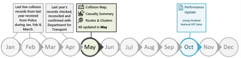
These milestones are interlinked with the Department for Transport (DfT) timelines; it takes up to April/May time to fully collect, check and validate the data with the DfT. Our maps and dashboards are then updated around May time.
Useful links
- Let us know if a collision has been plotted incorrectly via collisiondata@devon.gov.uk
- Max Driver educational programmes
- Travel Devon for your best travel options, inc cycle maps and training
- ‘Better Together’ which proposes new self-empowering partnerships to help people and communities control their own future.
- GOV.UK Road Accidents and Safety Statistics Guidance
- The Department for Transport
- Road Safety Knowledge Centre Information Directory
- EuroRAP Performance Safety Tracking of Europe’s Roads
- EuroNCAP Independent Car Safety Assessments
We take accessibility seriously and have incorporated accessibility functionality to our power BI dashboard style reports to allow content to be as accessible as possible. If you find some of the information not accessible, need guidance or an alternative format email collisiondata@devon.gov.uk with details of any preferred format and the assistive technology you use.