Contents
Introduction
As Lead Local Flood Authority, Devon County Council must have a local flood risk management strategy in place for its area, this is a requirement under the Flood and Water Management Act 2010.
The strategy provides guidance for both flood risk practitioners and the public regarding flood risk management issues. It outlines the role and responsibilities of the Risk Management Authorities across Devon. Furthermore, it also sets out the flood risk plans across Devon for the next 6 years illustrating the prioritised areas to be considered over the next 6 years investment period, it highlights how they were prioritised and an action plan will be updated each year detailing investment plans.
Our vision is to be a leading authority in the management and reduction of flood risk in the County of Devon, whilst achieving the following objectives:
1. We will reduce flood risk to properties and significant infrastructure, and enhance the local economy:
Measured by the number of communities, properties and significant infrastructure with reduced flood risk as a result of intervention by Risk Management Authorities.
2. We will co-ordinate Risk Management Authorities and encourage collaborative working:
By the successful delivery of Devon’s Flood Risk Management Action Plan collaborated through the Devon Flood and Water Management Group.
3. We will protect and enhance the natural environment, landscape and heritage assets, providing opportunities for carbon storage, energy generation and access and recreation where appropriate:
By following DCC internal environmental review processes and measuring environmental net-gain and change in the condition of heritage assets as a result of intervention by Risk Management Authorities.
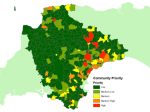
4. We will prioritise high risk communities:
Through our prioritisation criteria to identify at risk communities.
5. We will influence the planning process through our role as statutory consultee:
Measured by the volume of planning applications assessed.
6. We will set out a clear strategy:
Evidenced by the production of this document.
7. We will ensure the latest climate change predictions are incorporated into flood schemes and development proposals:
By following the latest UK Climate Projections.
8. We will improve resilience through community engagement and education:
Measured by the number of communities positively engaged and with emergency plans.
Who does what?
Between the Risk Management Authorities in Devon, flood risk is managed across the Devon County Council area:
Lead Local Flood Authorities
Devon County Council and Plymouth and Torbay Unitary Councils are LLFA’s. They are responsible for ordinary watercourses which is defined as a watercourse that is not a Main River, and includes streams, drains and ditches, and passages through which water flows. They are also responsible for both surface water and groundwater. As an LLFA both Plymouth and Torbay each have their own Local Strategy.
District Councils of Devon
East Devon District Council, Exeter City Council, Mid Devon District Council, North Devon Council, South Hams District Council, Teignbridge District Council, Torridge District Council and West Devon Borough Council
The district councils manage flood risk from costal erosion. They also have discretionary powers to carry out works on ordinary watercourses. They are responsible for managing and maintaining flood defence assets under their control and have a Local Planning Authority role to manage flood risk from all sources through appropriate planning policy and guiding development (Inc National Parks for their areas).
Environment Agency
The EA manages flood risk for Main Rivers, to determine if a watercourse is a Main River go to Devon’s online Environment Viewer. They are also responsible for the sea and reservoirs. They have a statutory advisory role for planning applications in Flood Zones for both main rivers and ordinary watercourses
South West Water
South West Water manages flood risk from public sewers (surface water, foul and combined) manholes, covers, pumping stations and combined storm overflows
Highway Authorities
Devon County Council, Plymouth and Torbay Unitary Councils and Highways England manage flood risks from surface water originating on the highway, highway drainage, gullies and culverts with riparian responsibilities.
Internal Drainage Boards
Braunton Internal Drainage Board manages flood risk from ordinary Watercourses, surface water and groundwater within their area.
Individual landowners
Individual landowners are responsible for managing flood risk from surface water from their own land, private sewers, drains and septic tanks. A person owning land whether with or without a watercourse has certain duties and responsibilities in managing water. When dealing with surface and/or groundwater a landowner has the right to allow natural flows onto lower ground and a duty to accept those from higher ground. With regards to a watercourse passing through or adjacent to their land they have riparian responsibilities to manage the bed and banks and maintain a free flow of water. Full details can be found in DCC’s leaflet: Living With Water
Who to contact?
Emergency
If it is an emergency and there is danger to life as a result of flooding you should not hesitate to call 999.
Flooding of the highway and blocked drains
To report flooding of the highway and blocked drains contact Devon County Council’s Highway Customer Service Centre on 0345 155 1004 or report a problem online. Office hours are Monday to Friday 8am – 8pm and Saturdays 9am – 1pm. For emergencies outside of these hours call 0345 155 1008
Flooding on major trunk roads
For any flooding on major trunk roads (the M5, A30, A38, A35 and A303) contact the Highways Agency on 0300 123 5000 (24 hour service)
Flooding from sewers and water
To report flooding from sewers and water pipes contact South West Water on 0344 346 2020 (24 hour service)
Flood warnings
For enquiries about flood warnings contact the Environment Agency’s Floodline on 0345 988 1188 (24 hour service)
General queries
For general queries about Main River or flooding from the sea contact the Environment Agency on 03708 506 506, email enquiries@environment-agency.gov.uk or visit www.gov.uk/environment-agency
For all other flooding queries contact Devon County Council Flood Risk Management Team on 01392 383000 (ask for ‘flood risk’), email floodrisk@devon.gov.uk or visit www.devon.gov.uk/floodriskmanagement
Preparing for a flood
Please refer to Devon County Council and Environment Agency web pages for advice on what to do before, during and after a flood.
In the first instance of local flooding and sandbag requests contact your local District Council or Parish Council to determine the availability of sandbags in your area.
What we will do?
In accordance with the Flood & Water Management Act DCC will:
- Develop and maintain a Local Strategy for Flood Risk Management in Devon
- Land Drainage Consent to works on Ordinary Watercourses
- Enforce removal of unconsented works
- Maintain a freeflow of water in an Ordinary Watercourse through enforcement
- Develop and maintain a Register/Record of significant flood risk assets
- Designate structures/features with significant flood risk benefits
- Carry out flood investigations following significant flood events
- Provide comments on surface water management proposals for new major development applications as statutory consultee
Item 1. Flooding significance thresholds
Investigation reports under Section 19 of the Flood and Water Management Act will be considered by DCC for events with a significance threshold level of:
- 5 or more residential properties internally flooded (in one area, e.g. one street)
- 2 or more commercial properties internally flooded.
- Critical infrastructure affected (e.g. roads or rail links closed).
- Critical services affected.
OR if the above criteria are not met:
- History of repeated flooding. The frequency of flooding greater than 3 occurrences of internal property flooding within 5 years or similar frequency felt to be significant.
- The incident is part of a widespread flood event.
- The vulnerable are particularly at risk, such as the elderly, young children, those living with a disability or living in areas of deprivation.
- Significant negative impact on the natural environment.
Flood risk management in Devon – What do we do?
When a flood risk is identified we:
- Consider the source of flooding. Liaise with relevant Risk Management Authority
- Consider appropriate opportunities and measures for delivering flood risk management, following hierarchy in Part 2
- Prioritise community as detailed in Part 2 of the main document and Item 1
- Create annual Action Plan
How we respond to flood events:
- Understand what has happened. Does it reach the threshold for investigation?
- If yes, produce S.19 Investigation Report and recommend actions
- If no, keep details on record to feed into prioritisation in Item 1
- Run through steps above for ‘identified flood risk’ in this table to consider further actions
Local land drainage issues:
- Consider if the issue can be resolved by liaising with Risk Management Authority and/or landowner direct
- If yes, take enforcement action if appropriate
- If no, site visit, letter or appropriate advice to be given
- If intervention required then run through steps above for ‘identified flood risk’ in this table
Watercourse regulation, permissions required and land owner responsibilities:
- Receive Land Drainage Consent application, enquiry or notification of activity in a watercourse
- Consider if the proposal or activity requires Land Drainage Consent or an Environmental Permit
- Consult with any relevant parties, such as the Environment Agency fisheries and biodiversity experts
- Process the application within 2 months or take appropriate enforcement action against activities contravening the Land Drainage Act 1991
Planning, development and infrastructure:
- Receive consultation request from the Local Planning Authority (LPA) or direct from developer if Pre-App Request
- Review surface water management proposals and provide consultation response to LPA or advice to Pre-App requestor
- Have all statutory bodies required commented on flood risk aspects?
- LPA to consider responses and set out any specific conditions required to satisfy flood risk and surface water management
Are you at risk of flooding?
Where to find flood risk maps and data?
To find out if you are at risk of flooding, please view our flood risk maps. Furthermore, the Environment Agency provides a flood warning system which monitors rainfall, river levels and sea conditions 24 hours a day and this information is used to forecast the possibility of flooding. Find out more and sign up for flood warnings in the Devon area.
Report flooding to us

FORT, the Flood Online Reporting Tool enables the collation of flooding information from the public and RMAs during and post flood event. This data is essential to our internal records as it will help with any future investigation and potential investment. More information about how we use FORT can be found in post flood event community engagement .
Climate change and flood risk management
Climate change is an important issue at the forefront of the decisions we make. With more intense and frequent rainfall expected as a result of climate change it is essential to ensure places and communities are resilient to flooding now and in the future. The effects of climate change are considered to be a very high risk to the increased threat of flooding with many drainage systems and historic flood defences at risk of being overwhelmed as a result.
Furthermore, when considering future flood schemes, it is key to have natural sustainable solutions incorporated so that even when we have a hard-engineering scheme, natural flood management should be incorporated. To support this strategy DCC has produced a NFM Guidance Document for Devon, to guide and inform landowners engaged with managing flood risk. Further guidance is available online, providing information on the evidence behind NFM: Working with Natural Processes – Evidence Directory and where to find opportunities for maximising the benefits of NFM through the Working With Natural Processes mapping tool.
Current climate change predictions are always considered in any flood risk study or catchment modelling used to develop improved flood defences and also in our role as statutory consultee for all major planning applications. Within planning, adaptation is essential so that development and infrastructure planning regimes can help ensure our communities are more resilient for the future.
Increasing community resilience and awareness

As a result of flood risk and climate change predictions for the future, increasing community resilience and engagement is key. Help and guidance is available for local communities from the Devon Community Resilience Forum, which is supported by the Environment Agency, Devon County Council, Emergency Services and community members. Facilitated by the charity Devon Communities Together, the forum supports communities to build their resilience.
Communities must prepare themselves, with assistance from organisations to adapt to a new way of life to accommodate some impacts of future climate change and understand where tough decisions may have to be made. Communities should have precautionary measures in place to limit potential damages. In terms of flood risk this could include any flood warnings or emergency plans that are aligned to the Local Strategy. Communities can also improve their resilience by setting up local flood groups and becoming flood wardens.
Our plan going forward
Over the next 6 years…
Devon’s local flood risk management strategy sets out the prioritised areas to be considered from 2021-2027. There are currently 17 communities identified as medium to high risk that are to be considered for investigation and potential investment. This list will be monitored regularly and be subject to change.
To address the priority communities, a hierarchy of flood risk management measures will be used that follows the principles of promoting more sustainable natural processes in the first instance, either as sole measures or in combination with hard engineered solutions. The introduction of natural flood management measures will help to reduce the scale, or need, of hard engineered solutions. Community resilience and preparedness will always be fundamental for all communities, by managing local flood risk and preparing for future climate change impacts and adaptation.
Over the next 12 months…
Once communities are prioritised and funding is either secured or being sourced, areas of investment, such as investigation, design or scheme delivery that are to be progressed will be recorded on Devon’s Action Plan.