What is natural flood management?
Natural flood management (NFM) is the implementation of natural measures which help to alleviate the risk of flooding. This is something also referred to as working with natural processes (WWNP). The techniques involved in NFM/WWNP are primarily focused on increased infiltration, water storage and slowing flows and work best when a catchment-based approach is taken managing the problem from source to sea. NFM can take many forms so selecting the right technique(s) is essential in providing the maximum benefit.
NFM measures will never completely replace traditional engineering techniques but are designed to complement them and when they do, evidence from WWNP has found that it is an effective tool in reducing the risk of flooding. NFM is also beneficial in situations where hard engineering is not a viable option. NFM measures can be used in combination with each other to provide a greater reduction to flood risks and the wider environment. Using the right combination can reduce the depth and duration of flooding as well as slowing flood peaks.
High Water Common Ground
The High Water Common Ground video meets the communities most affected by flooding, examines the needs of the parties involved, and explores some of the most innovative methods of flood risk management using real examples from around the country.
Devon County Council’s NFM guidance for Devon
Devon County Council has produced an NFM guidance for Devon. This guidance is designed to provide a summary of relevant information on NFM specifically targeted to Devon. The guidance is intended for use primarily by landowners and farmers but may also be a useful document for larger organisations including other risk management authorities.
The NFM Guidance for Devon documents:
PDF Version – NFM Guidance for Devon
Accessible Format (Webpage) – NFM Guidance for Devon
Land Drainage Consent / Environmental permit
Work to an ordinary watercourse or main river will require a Land drainage consent from Devon County Council or an environmental permit from the Environment Agency.
Useful NFM links
Current NFM projects in Devon
-
Woods for Water
The Woods for Water NFM project is running from December 2017- March 2021 led by North Devon Biosphere with Blackdown Hills AONB coordinating locally. The projects overall target is to restore natural catchment performance in order to combat flooding and improve water quality.
The river Culm is facing a number of problems including a risk from flooding and a falling water quality, with the surrounding catchment area suffering from degraded soil and widespread development. It was recognised from the beginning of this project that the solution to these problems involved engaging and including local people. Therefore, as part of the project there has been a lot of involvement with landowners and farmers to install a number of NFM measures through the Culm area. As landowners have the best knowledge of their land and any watercourses that run through it, they are best placed to decide where measures would be best installed.
The Woods for Water project is designed to target woodland creation and woodland management. It supports landowners to plant and manage woodland along with other NFM measures such as log dams, swales and improved land management practices.
-
Connecting the Culm
The River Culm measures just 40km from its headwaters in the Blackdown Hills AONB (Somerset) to its confluence with the River Exe in Devon. The Connecting the Culm project is a three-year program running from January 2019 to June 2020 which aims to make the River Culm and its floodplains more resilient to flood and drought, improve the water quality and support biodiversity and habitat. The project has been developed by a partnership of organisations including the Devon County Council, Environment Agency, Mid Devon District Council and National Trust and is led by the Blackdown Hills AONB.
Some problems that the River Culm is currently facing include water quality issues with whole lengths of the river failing water quality targets including diffuse, point pollution and high sediment loads. There are also large areas of degraded and compacted agricultural land and the headwaters of the river which once supported mires that act as sponges have been converted and reduced in size due to changes in agricultural processes.
Examples of the “nature-based solutions” that will be involved in the Connecting the Culm project are:
- Removing old drainage systems to re-hydrate and restore hydrological function of natural capital rich spring-line and valley mires, providing a range of ecosystem service benefits including flood attenuation and carbon storage in peat rich soils
- Damming streams and drainage channels using natural woody debris to create attenuation ponds and silt traps, reducing flood peaks and reducing downstream sedimentation
- Innovative flood alleviation features on land associated with new, large developments, showing how multi-use green infrastructure is deliverable, unlocking significant added benefits
- Coppicing and laying bank-side trees to imitate beaver activity, improve water oxygen levels and reduce livestock disturbance of the river bed
- Reconnect the river to its floodplain and restore more natural floodplain function on intensive agricultural land, to re-create floodplain attenuation features, restore wetland habitat and unlock other ecosystem service benefits including enhanced access and recreation
- Community-based and driven solutions to tackle the challenges faced by the river and its floodplain including supporting community land trusts, collaborations of small-scale landowners and community-focused interventions.
-
Dartmoor Headwaters Project
There are 10 Main River catchments that originate upon Dartmoor, all of which lead to locations that have experienced flood events in recent years. Dartmoor is often subject to rapid flash flood events due to the high elevation topography of the area. The Dartmoor Headwaters Project is a partnership between Dartmoor National Park Authority and the Environment Agency. This project hopes to alleviate some of the flood risk posed to these areas by targeting the issue at its source – the headwaters.
The pilot for this project (2018-2021) is looking at the effectiveness of using natural river processes, land management techniques and soft engineering approaches to reduce the flood risk to local communities whilst improving water quality and biodiversity. Five catchments have been chosen, based on them being steep in nature and subject to rapid onset of flooding and all have flooded in the past few years. These are small communities where a traditional hard engineering approach would not be viable, not least due to the cost. The project is working with local landowners to implement measures such as soil survey and remediation advice (such as aeration), reconnecting the river with its floodplain, tree planting, peatland restoration, gully blocking, stone dams, wetland creation, new Devon banks to divert water and infiltration pits to help with run-off. The success of these measures will be monitored, with a view to extending this work to much wider areas in the future.
NFM will be implemented in a grouped manner with one NFM type of method per area. This is coupled with a monitoring regime which will be able to give evidence towards the effectiveness of methods available.
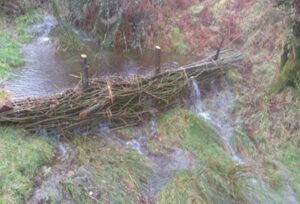
Trialling leaky dams
The issue: Flood risk to homes and property begins high up in the catchment near the heads of our rivers. With heavy rainfall on Dartmoor water can run-off moorland at speed, helped by erosion channels, mining gullies and tightly grazed grassland with little structure to intercept the water.
Trialling a solution: The use of leaky dam structures to ascertain which ones work best, where and why to inform future projects.
Where? The dams are located on Buckfastleigh and Dean Commons, with some also on private land.

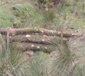
Natural log dams – made from fallen timber and brash usually found in situ and pegged firmly in place with stakes. Normal flows leak through the structure as normal. 
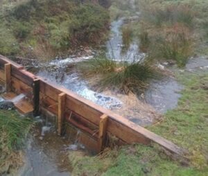
Timber dams – mostly made from untreated oak sleepers for durability against weather and livestock interference. The lower boards have small gaps to allow leakage during normal flows. The boards weather and blend in given time. 
Wool dams – fleeces stuffed into hessian rolls, pegged into place with live willow stakes. Full of water they allow sphagnum moss to colonise and other wetland plants to flourish in the pools. 
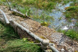
Stone dams – built to be deliberately leaky. Water leaks through the face of the dam and percolates slowly through the smaller stone behind. These are expensive to build and access to deliver stone is limited. 
Live willow faggot dams are naturally leaky structures, great for trapping silt and debris. As they grow their roots help to stabilise the structure and improve infiltration. Faggots can also be pegged down lengthways into eroded channels and holes to break flows and slow further erosion. The results: are promising after several winter storms. Many lessons have been learned from using these different techniques. The full benefit of the dams will only be seen over time by building upon this work all over the catchment.
-
Culm Grassland Project
Devon Wildlife Trust has been working with landowners and farmers to restore and create grassland through the Culm Grassland NFM Project. Culm acts as a way of slowing and storing water that would otherwise enter watercourses or create flood water runoff. Research has found that culm can hold up to five times as much water as intensive grassland during extreme weather events.
Culm grassland is a type of purple moor grass and rush pasture that within the UK is found mostly in north Devon. The Culm Grassland project has four key aims – to learn more about how culm grassland can help reduce flood risk; to increase public understanding about the value of culm grassland; to work with landowners to restore and re-create culm grassland sites; and to share learning across the south west, the UK and Europe.
Because this project worked so closely with landowners one of the big focuses is on the additional multiple benefits that NFM can deliver such as its ability to filter pollutants and retain carbon.
Between April 2018-March 2019 136.8ha of grassland habitat has been restored over 25 sites influencing 17.16km of river. Alongside this restoration and creation of grassland (which includes management such as planting, swaling and scrub clearance) gates and fences have also been installed as a way of managing the land and river access and controlling grazing.
Last updated: April 2021