Contents
Foreword

In line with the Flood and Water Management Act 2010 Devon County Council, as the Lead Local Flood Authority, must develop, maintain, apply and monitor a strategy for local flood risk management in its area. This Local Strategy replaces the previous document published in 2014, which required a review after 6 years. The emphasis remains on the ‘local sources’ of flood risk defined in the Act as ground water, surface water and ordinary watercourse but continues to recognise how this interacts with other risks from Main Rivers and the sea.
The Environment Agency published the National Flood and Coastal Erosion Risk Management Strategy in July 2020 and this Local Strategy is aligned to the key national theme of improving resilience of our communities within Devon. In order to achieve this all Risk Management Authorities must work together in partnership as well as with all the key stakeholders, communities and individual property/landowners.
The main purpose of the Strategy is to set out how flood risk will be managed in Devon. It will identify who has responsibilities for what element, how they will work together and what will be done to reduce the risk. Throughout the document there is a set of Principles to guide flood risk management practitioners on what is expected of them and interactive links to relevant information outside of the Strategy.
The effects of climate change, with more intense rainfall events are a growing concern and are considered for all flood risk management activity. This is particularly relevant for the reviewing of development proposals to ensure flood risk is not increased as a result. The use of sustainable drainage and natural flood management measures will be encouraged for all development and flood improvement works.
A new addition to this revised Local Strategy is an indication of our highest priority communities that we aim to investigate over this next 6 year period. Opportunities for other communities will also be considered where possible and the Annual Action Plan will support the delivery of this Local Strategy.
Councillor Roger Croad
Devon County Council Cabinet Member for Community, Public Health, Transportation and Environmental Services
Executive Summary
Why Devon needs a Local Flood Risk Management Strategy
Under Section 9 of the Flood and Water Management Act 2010 Devon County Council (DCC), as the Lead Local Flood Authority (LLFA), must develop, maintain, apply and monitor a strategy for local flood risk management in its area. The first Local Strategy was published in 2014 and is required to be reviewed after 6 years. This document sets out our updated strategy for the period 2021-2027.
Devon is a considered to be a very rural county with many steep sided catchments and two coastlines. As such the risk of flooding can be from all sources of pluvial, fluvial and tidal events. A large percentage of communities are relatively small in terms of property count and commercial businesses, compared to other more urban areas with larger cities. This provides further challenges in obtaining levels of funding, which is predominantly focused on the reduction of risk to residential property, although other environmental and infrastructure benefits that can be achieved will enhance the funding opportunities.
Our Vision
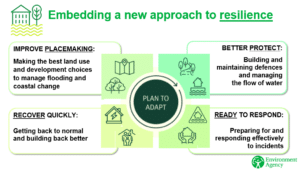
To be a leading authority in the management and reduction of flood risk in the County of Devon. We will work efficiently and collaboratively with our partners and engage with communities to make Devon more resilient to flooding and ready to adapt to climate change by promoting sustainable flood risk management and using natural solutions where possible. In response to the climate and ecological emergency, flood risk infrastructure will play its part in achieving a net-zero carbon Devon and protecting and enhancing the natural environment – indeed natural flood risk management solutions will be considered before hard engineering. Additionally, flood risk infrastructure will take opportunities to improve communities’ access to and enjoyment of green spaces, and to conserve and enhance local landscape and heritage assets.
Who does what?
Risk Management Authorities (RMAs), Local Planning Authorities (LPAs) and riparian landowners have statutory or legal responsibilities for flood risk management. This strategy summarises the roles and responsibilities under current legislation with a particular focus on the role of Devon County Council, as the Lead Local Flood Authority and the other RMAs. It will also consider the roles of other key stakeholders, such as non-government organisations, Parish/Town Councils, Communities and the property owners themselves and how they should all work together to manage the risk of flooding.
What we will do
To achieve the vision and objectives in this strategy, we have set out a series of Principles to guide the Risk Management Authorities in Devon:
Principle 1: Integrated Flood Risk Management and Partnership Working
Through collaborative working, Devon Risk Management Authorities will consider opportunities for multiple benefits and the alignment of programmes to maximise funding availability, delivering effective, consistent and integrated flood risk management.
Principle 2: Addressing the Skills Gap
Where skills gaps are identified in local flood risk management, we will seek opportunities through internships, apprenticeships and graduate programmes, in addition to specialist consultants when required. Ongoing training and upskilling of existing staff will also be maintained.
Principle 3: Improving Data Quality and Management
Devon Risk Management Authorities will keep up to date and accurate records of flood risk data and will ensure government guidance is followed on the use of geographical information systems and maintaining metadata, enabling efficient data use and storage, sharing with partners when appropriate.
Principle 4: Maintaining an Asset Register and Record
Devon County Council will continue to populate its asset register with flood risk features thought to have a significant impact on flood risk, ensuring that this is up to date with national developments and guidance and that the assets recorded are used as a vital part of assessing local flood risk.
Principle 5: Designating Flood Risk Features
Devon Risk Management Authorities will use the powers to designate any structures and features that are considered to affect flood risk, including those which were not necessarily designed or constructed for that purpose.
Principle 6: Investing in Local Flood Risk Management
All Risk Management Authorities in Devon will work in partnership to deliver local flood management schemes and initiatives. An investment plan will be developed through collaborative working and will be outlined in our list of Priority Communities, the South West Flood Risk Management Plan and flood risk management measures outlined in Part 2 of this Strategy. Funding will be sought through the relevant opportunities such as FDGiA, Local Levy, local authority capital budgets and private contributions.
Principle 7: Sharing of Investment Programmes
The South West Flood Risk Management Plan will pull together the investment programs of Risk Management Authorities (RMAs) and signpost to more details on individual RMA action plans. The sharing of investment programmes and project plans will be encouraged between all of the RMAs, using the already established Devon Flood and Water Management Group and the new South West Integrated Framework Team (SWIFT) to discuss and prioritise investment in local flood risk management.
Principle 8: Seeking additional funding
Devon Risk Management Authorities will seek additional funding from the national, regional and local sources and take the opportunity to obtain funding through other government initiatives, as they arise, to implement location-specific actions identified in the Action Plan.
Principle 9: Flood Risk Management Studies
Devon Risk Management Authorities will continue to work in partnership and develop studies in order to better understand and reduce flood risk and improve community resilience.
Principle 10: Encourage Sustainable Drainage Systems (SuDS)
Devon Risk Management Authorities will encourage the use of SuDS and promote the benefits, such as improving water quality, biodiversity and amenity, channelled throughout various groups, development management and through advice on Local Authority Core Strategies, development plans and policies. Devon County Council will give guidance to Planning Authorities and the development industry as a Statutory Consultee, fulfilling a duty to check and approve sustainable drainage system designs for major developments.
Principle 11: Consenting to works on Ordinary Watercourses
Devon County Council will regulate works on ordinary watercourses, ensuring that any activity will not increase flood risk and will encourage sustainable measures and methods in doing so. This will be in line with the regulation of main rivers by the Environment Agency maintaining a consistent approach across Devon.
Principle 12: Natural Flood Management
Risk Management Authorities will promote natural flood management measures (where appropriate) in all flood investigations and improvement projects, either as sole measures or in combination with hard engineering solutions, including supporting NFM initiatives throughout Devon. We will also promote sustainable land management which seeks reduced rates and volumes of surface runoff, erosion and sediment transport by endorsing education and awareness campaigns as part of community engagement projects.
Principle 13: Sustainable Management of Local Flood Risk
We will reduce the risk of flooding to property and significant infrastructure to enable resilient economic activity that provides for communities’ needs whilst conserving, enhancing and providing access to Devon’s natural environment, green spaces, landscapes and heritage assets and demonstrating progress towards net-zero carbon emissions from LFRMS activity by 2050 to contribute to Devon’s response to the climate and environmental emergency.
Principle 14: Adapting to Climate Change
Devon Risk Management Authorities will use the latest UK Climate Projections to make resilient flood risk management decisions for the effects of climate change. Where necessary difficult choices about the future protection of property and infrastructure will need to be made.
Principle 15: Raising Awareness and Improving Communication and Involvement
Through collaboration with other Risk Management Authorities and the Devon Community Resilience Forum, all Partners will work together towards raising public awareness (including those that are most vulnerable such as the elderly, young children, those living with a disability or living in areas of deprivation) about flood risk and the roles of the Risk Management Authorities, providing clear and up to date information.
Principle 16: Property Flood Resilience
When wider flood alleviation schemes for a community or individual property are not viable or unable to be delivered in the foreseeable future, Risk Management Authorities will remain committed to making properties more resilient to flooding through the installation of Property Flood Resilience measures where possible.
Principle 17: Working with Emergency Responders
The Lead Local Flood Authority and District Councils of Devon, through their Emergency Planning services, will continue to work with emergency responders to develop plans and provide information to inform operational decisions in support of a Devon that is resilient to flooding.
Principle 18: Recording and Investigating Flood Events
Devon County Council, in partnership with the Environment Agency, will record local flood incidents reported through Risk Management Authorities and the public in order to build up a picture of risk for current and future work. Those that reach Devon’s significance thresholds will be investigated under Section 19 of the Flood and Water Management Act and the reports will be published online.
What we will do over the next 6 years:
Part 2 of Devon’s local strategy sets out the prioritised areas to be considered within the next 6 year investment period, in line with Defra’s national funding program. Here we show how communities have been prioritised and what options for investment will be considered. The annual action plan detailing specific investment will be updated each year to form Part 3 of this strategy.
To address the priority communities, a hierarchy of flood risk management measures will be used that follows the principles of promoting more sustainable natural processes in the first instance, either as sole measures or in combination with hard engineered solutions. The introduction of natural flood management measures will help to reduce the scale, or need, of hard engineered solutions. Community resilience and preparedness will always be fundamental for all communities, by managing local flood risk and preparing for future climate change impacts and adaptation.
Glossary
ASA – Association of SuDS Authorities
DCC – Devon County Council
Defra – Department of Environment, Flood and Rural Affairs
EA – Environment Agency
EU – European Union
FDGiA – Flood Defence Grant in Aid
FORT – Flood Online Reporting Tool
FRMP – Flood Risk Management Plan
GIS – Geographic Information System
HRA – Habitat Regulations Assessment
LLFA – Lead Local Flood Authority
LPA – Local Planning Authority
LRF – Local Resilience Forum
NFM – Natural Flood Management
PFR – Property Flood Resilience
RBMP – River Basin Management Plan
RMA – Risk Management Authority
SEA – Strategic Environmental Assessment
SuDS – Sustainable Drainage System
SWW – South West Water
Part 1: Strategic vision & objectives: Why we are producing this strategy
Introduction
Why Devon needs a Local Flood Risk Management Strategy
Under Section 9 of the Flood and Water Management Act 2010 Devon County Council (DCC), as the Lead Local Flood Authority (LLFA), must develop, maintain, apply and monitor a strategy for local flood risk* management in its area (Figure 1). The first Local Strategy was published in 2014 and is required to be reviewed after 6 years. This document sets out our updated strategy for the period 2021-2027.
A map showing South West River Basin District, with Devon’s District Councils and National Parks. Devon’s LLFA area consists of the District Council areas shown.
*Local Flood Risk is defined in the Flood and Water Management Act 2010 as flooding from Surface runoff, ground water and Ordinary watercourses.
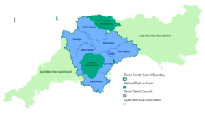
Table 1: Historic Acts of parliament, European legislation and national policy that have influenced current flood risk policy and legislation governing this strategy.
| European Legislation | Acts of Parliament | National Policy | Current Flood Risk Policy |
|---|---|---|---|
| EU Water Framework Directive 2000 | The Water Environment Regulations 2017 | River Basin Management Plans | |
| EU Floods Directive 2007 | Flood Risk Regulations 2009 | Preliminary Flood Risk Assessments Flood Risk Management Plans | |
| Public Health Act 1936 | National Planning Policy Framework 2012 | Local planning policy
National Flood and Coastal Erosion Risk Management Strategy* Local Flood Risk Management Strategies* *Requirement under the Flood and Water Management Act 2010 Drainage and Wastewater Management Plans | |
| Shoreline Management Plans | |||
| Civil Contingencies Act 2004 | Multi Agency Flood Framework Community Level Plans |
Devon County Council’s Vision for flood risk management
To be a leading authority in the management and reduction of flood risk in the County of Devon. We will work efficiently and collaboratively with our partners and engage with communities to make Devon more resilient to flooding and ready to adapt to climate change by promoting sustainable flood risk management and using natural solutions where possible. In response to the climate and ecological emergency, flood risk infrastructure will play its part in achieving a net-zero carbon Devon and protecting and enhancing the natural environment – indeed natural flood risk management solutions will be considered before hard engineering. Additionally, flood risk infrastructure will take opportunities to improve communities’ access to and enjoyment of green spaces, and to conserve and enhance local landscape and heritage assets.
Our vision and objectives will be achieved through a series of Devon Flood Risk Management Principles, which can be found throughout this document. All Devon Risk Management Authorities should follow these principles.
Devon County Council’s objectives for flood risk management
Our objectives fall under the three high level ambitions of the National Flood and Coastal Erosion Risk Management Strategy:
Devon local flood risk management strategy objectives meeting National Strategy Ambition of “Climate Resilient Places”:
1. We will reduce flood risk to properties and significant infrastructure, and enhance the local economy
Measured by the number of communities, properties and significant infrastructure with reduced flood risk as a result of intervention by Risk Management Authorities and key stakeholders.
2. We will co-ordinate Risk Management Authorities and encourage collaborative working
By the successful delivery of Devon’s Flood Risk Management Action Plan collaborated through the Devon Flood and Water Management Group
3. We will protect and enhance the natural environment, landscape and heritage assets, providing opportunities for carbon storage, energy generation and access and recreation where appropriate
By following a formal environmental review processes and measuring environmental net-gain and change in the condition of heritage assets as a result of intervention by Risk Management Authorities and key stakeholders.
4. We will prioritise high risk communities
Through our prioritisation criteria to identify at risk communities
Devon local flood risk management strategy objectives meeting National Strategy Ambition “today’s growth and infrastructure resilient in tomorrow’s climate”:
5. We will influence the planning process through statutory consultations
Measured by the volume of planning applications assessed
6. We will set out a clear strategy
Evidenced by the production of this document
Devon local flood risk management strategy objectives meeting National Strategy Ambition that “a nation ready to respond and adapt to flooding and coastal change”:
7. We will ensure the latest climate change predictions are incorporated into flood schemes and development proposals
By following the latest UK Climate Projections
8. We will improve resilience through community engagement and education
Measured by the number of communities positively engaged and with emergency plans
Strategic plans and assessments
25 Year Environment Plan
The government’s 25 year plan to improve the environment gives some direction to national and local flood risk management strategies. It recognises the implications of future climate change on flood risk and outlines sustainable measures to reduce the risk from flooding. The plan promotes expanding the use of natural flood management solutions, putting in place more sustainable drainage systems and making ‘at risk’ properties more resilient to flooding.
Our Local Strategy objectives align with the goals of the 25 year plan, including raising awareness of flood risk in communities and working with them to increase resilience, through increased preparedness and implementing flood alleviation schemes. It also highlights the importance of influencing decisions on land use and development, achieved through our role as a statutory consultee and through our involvement with Natural Flood Management initiatives.
National Flood and Coastal Erosion Risk Management Strategy
The National Strategy has three high level, long term ambitions:
Climate resilient places; today’s growth and infrastructure resilient in tomorrow’s climate and; a nation ready to respond and adapt to flooding and coastal change. The strategy calls for the nation to embrace a broad range of resilience actions including better protection to flooding and coastal change.
A series of medium-term strategic objectives focus on how the ambitions will be reached and a series of short-term measures outline the actions that will be taken to reach these objectives. Devon’s local strategy will align with the national measures, setting out what we will aim to achieve over the next six-year investment period, as well as considering the longer-term impacts and fulfilling the national objectives and ambitions.
Climate resilient places
This high level national ambition considers ensuring places and communities are resilient to flooding now and in the future with climate change impacts. The natural, built and historic environment needs to be protected through a mix of solutions, including hard engineering, making greater use of natural flood management measures and appropriate emergency planning and adaptation plans. Innovative ways to invest in long term flood risk management are required, considering new sources of funding. Alongside these defences a wider range of actions need to take place including avoiding inappropriate development on the floodplain and following a flood event helping communities to ‘build back better’ so that properties are more resilient to future flooding. ‘Adaptive pathways’ will enable local areas to create better plans for future flooding and adapting to future climate hazards.
Today’s growth and infrastructure resilient in tomorrow’s climate
This considers the need for planning and development to be resilient to climate change, where strategic plans have an important role to play in long term flood resilience. This can help to protect people, infrastructure, and enhance the natural environment and local economy. Property owners should be encouraged to ‘build back better’ after flooding to reduce future flood damages and to enable a faster recovery in the future.
A nation ready to respond and adapt to flooding and coastal change
Involving individuals and communities in local decision making processes is an important part of improving resilience. Through raising awareness and ensuring the risks are better understood, communities can be better prepared for flood and coastal change and the need for possible tough decisions to be made as we adapt for the future. Devon has a role in engaging and improving communication and communities have a role to respond proactively to this engagement.
Flood Risk Management Plans
The Flood Risk Regulations 2009 require the production of Flood Risk Management Plans (FRMPs) to set out at a high level how organisations, stakeholders and communities will work together to manage flood risk. These plans are being delivered by the Environment Agency and are set at a River Basin Management Plan catchment level, of which Devon sits in the South West catchment. The Environment Agency has delivered a series of River Basin Management Plans (RBMPs), which are a requirement of the Water Framework Directive. These plans focus on water quality and improvement, including the importance of managing flood risk, reducing pollution from runoff and increasing the use of sustainable drainage.
The first Flood Risk Management Plan for the South West was produced for the period 2015 to 2021 and included a long list of all known risks and potential improvements for future consideration. The new revised plan, set to be published in 2021, has been developed with closer communication between RMAs to include a more targeted and realistic plan of action for the 6 year funding programme.
Devon’s local strategy focusses on the management of risk from surface water, ground water and ordinary watercourses and will closely link with the FRMP and RBMP for the South West in terms of the catchment-based approach, multiple benefits to be achieved and partnership working. Devon’s High-Risk Communities and annual Action Plan will be reflected in the FRMP, which will provide a more holistic view of all flood risk activity being considered by all of Devon’s Risk Management Authorities.
National Flood Risk Assessment (NaFRA2)
The Environment Agency is reviewing the National Flood Risk Assessment in partnership with other Risk Management Authorities. The original NaFRA, published in 2004, included risk from rivers and the sea, however this revision will now include the risk from surface water also. The NaFRA2 system will be the first cloud-based system designed to store, process and manipulate input data and manage outputs to help build a full picture of the nature of flood risk.
To assist RMAs in managing flood incidents, modelling scenarios will be created to show different ways of defending against various flood events, breaching of defences, blockages and/or the effects of climate change. This project will be ongoing through the early stages of this Local Strategy and is planned to be rolled out in 2024. All relevant data and information gathered during the Local Strategy period will be fed into the NaFRA2 project.
Shoreline Management Plans
A Shoreline Management Plan (SMP) is a large-scale assessment of the risks associated with coastal processes and helps reduce these risks to people and the developed, historic and natural environments. The SMPs set the strategic policy direction for coastal management and identify the most sustainable approaches to managing the risks to the coast in the short, medium and long term. A set of preferred policies are identified and assigned to ‘policy units’ for each SMP epoch. These policy options are: Hold the Line (HTL), Advance the Line (ATL), Managed Realignment (MR) and No Active Intervention (NAI).
Drainage and Wastewater Management Plans
DWMPs provide the basis for more collaborative and integrated long-term planning by organisations that have interests and/or responsibilities relating to drainage, flooding and protection of the environment. Whilst the production of DWMPs will be led by water companies, all other Risk Management Authorities have a part to play in their creation. More information can be found on South West Water’s Drainage and Wastewater Management Planning document.
Strategy assessments
As part of this strategy, we are required to complete a range of assessments to consider environmental, social and socio-economic impacts as options are developed for improving and managing flood risk in Devon. Therefore, this strategy is accompanied by a Strategic Environmental Assessment, a Habitat Regulations Assessment (to ensure that this strategy will not adversely affect European protected sites) and an Equality Impact Assessment. All of which can be found in the supporting documents
Roles and Responsibilities – Who Does What?
Risk Management Authorities (RMAs) in Devon
RMAs have responsibilities for managing the risk of flooding from different sources, as summarised in Item 1 below and detailed on Devon’s Flood and Coastal Risk Management web pages.
Item 1: Risk Management Authorities in Devon and flood risk source they are responsible for.
Lead Local Flood Authorities:
Devon County Council, Plymouth and Torbay Unitary Councils manage flood risks from:
- Ordinary Watercourses
- Surface water
- Groundwater.
‘Local’ Flood Risk As LLFAs, Plymouth and Torbay each have their own Local Strategy.
District Councils of Devon:
East Devon District Council, Exeter City Council, Mid Devon District Council, North Devon Council, South Hams District Council, Teignbridge District Council, Torridge District Council, West Devon Borough Council manage flood risk from:
- Coastal erosion.
- Discretionary powers to carry out works on ordinary watercourses
- Managing and maintaining flood defence assets under their control
- Local Planning Authority role to manage flood risk from all sources through appropriate planning policy and guiding development (Inc National Parks for their areas)
Environment Agency:
- Main Rivers*
- The sea
- Reservoirs.
- Strategic overview of all flood risk Statutory advisory role for planning applications in Flood Zones for both main rivers and ordinary watercourses
South West Water:
- Public sewers (surface water, foul and combined)
- Manholes
- Covers
- Pumping stations
- Combined storm overflows
Highways Authorities:
Devon County Council, Plymouth and Torbay Unitary Councils, Highways England manage flood risks from:
- Surface water originating on the highway
- Highway drainage
- Gullies and culverts with riparian responsibilities
Braunton Internal Drainage Board:
Braunton Internal Drainage Board manage flood risk only within their area:
- Ordinary Watercourses
- Surface water
- Groundwater
Others:
Individual Landowners:
- Surface water from own land
- Private sewers
- Drains and septic tanks on own land
- Watercourse maintenance/riparian responsibilities+
*To determine if a watercourse is a Main River go to Devon’s online Environment Viewer
+Rights and responsibilities of land owners with watercourses can be found in Devon’s leaflet Living With Water
Individual Landowners
A person owning land whether with or without a watercourse has certain duties and responsibilities in managing water. When dealing with surface and/or groundwater a landowner has the right to allow natural flows onto lower ground and a duty to accept those from higher ground. With regard to a watercourse passing through or adjacent to their land they have riparian responsibilities to manage the bed and banks and maintain a free flow of water. Full details can be found in DCC’s leaflet: Living With Water.
Other Key Stakeholders
As well as those listed above with statutory or legal responsibilities there are a much wider group of organisations and individuals that come together to manage flood risk in their area. These include non-government organisations, parish/town councils, local flood action groups, the communities themselves and individual property/landowners. The local knowledge, awareness, understanding and ownership of their risk is critical in managing and reducing the effects of flooding. Key stakeholders are an integral part of the team.
What DCC will do as the LLFA
In accordance with the Flood & Water Management Act DCC will:
- Develop and maintain a Local Strategy for Flood Risk Management in Devon
- Land Drainage Consent to works on Ordinary Watercourses
- Enforce removal of unconsented works
- Maintain a freeflow of water in an Ordinary Watercourse through enforcement
- Develop and maintain a Register/Record of significant flood risk assets
- Designate structures/features with significant flood risk benefits
- Carry out flood investigations following significant flood events
- Provide comments on surface water management proposals for new major development applications as statutory consultee
In addition to the duties above DCC will:
- Explore opportunities for funding towards flood risk management activities
- Subject to funding, carry out detailed flood assessments, studies and surface water management plans
- Subject to cost benefit justification and funding, develop and deliver flood improvements and resilience measures
Partnership and joint working
Flood risk management in Devon involves a wide range of organisations and authorities with different roles and responsibilities, making it essential to have an effective partnership working approach. Item 2 outlines the governance structure in Devon.
Principle 1: Integrated Flood Risk Management and Partnership Working
Through collaborative working, Devon Risk Management Authorities will consider opportunities for multiple benefits and the alignment of programmes to maximise funding availability, delivering effective, consistent and integrated flood risk management.
Principle 2: Addressing the Skills Gap
Where skills gaps are identified in local flood risk management, we will seek opportunities through internships, apprenticeships and graduate programmes, in addition to specialist consultants when required. Ongoing training and upskilling of existing staff will also be maintained.
South West Regional Flood and Coastal Committee
South West Regional Flood and Coastal Committee covers the LLFA areas of Devon, Cornwall, Isles of Scilly, Torbay and Plymouth and provides a link between RMAs to understand flood and coastal erosion risks across the region and to encourage efficient, targeted risk based investment to benefit local communities. It also sets direction for the region’s drainage and coastal groups.
Devon Flood and Water Management Group
The Devon Flood and Water Management Group provides a forum, attended by officers from all Risk Management Authorities and key stakeholders in Devon, to discuss current and future affairs and share best practice to aid the delivery of efficient and high-quality flood risk management services in Devon. Members of the group include representatives from:
- Devon County Council (LLFA and Highway Authority representatives)
- Devon District and Unitary Councils
- Cornwall Council
- Environment Agency
- South West Water
- Highways England
- Network Rail
Further information on the Devon Flood and Water Management Group and its Terms of Reference can be found on the DCC Flood Risk Management web pages.
South West Integrated Framework Team (SWIFT)
SWIFT is a new collaborative partnership is being established between all of the South West Risk Management Authorities. Led by South West Water, in conjunction with their Drainage and Wastewater Management Plan, the group will share and align programmes to maximise funding opportunities and achieve multiple benefits.
Devon Community Resilience Forum
Devon Community Resilience Forum is supported by the Environment Agency, Devon County Council, Emergency Services and community members. It promotes and supports community resilience in Devon. More information about this valuable resource is provided under the Community resilience and engagement section.
Association of SuDS Authorities (ASA)
ASA is a member organisation for Local Authorities, to promote and provide national consistency on SuDS. ASAs aim is to promote and develop the use of sustainable drainage within all new developments, including:
- To share and promote good practice to enhance the effectiveness of sustainable drainage.
- To own and develop the guidance for the Non-Statutory Technical Standards for Sustainable Drainage Systems.
- To engage with Government in developing policy and regulation for surface water management.
Item 2. Governance structure for local flood risk management in Devon:
Project board:
Senior users: South West Regional Flood and Coastal Committee County Council Members
Senior suppliers: Head of Service for Planning, Transportation and Environment and Environment Manager
Executive: Cabinet Member for Community, Public Health, Transportation and Environmental Services
Delivery:
Project assurance: DCC Place Scrutiny Committee
Project support: Environment Agency; District Councils; South West Water; Braunton Internal Drainage Board; Devon County Council; National Farmers Union; Planning Authorities; Emergency Planning; Highway Authority; Natural England.
Project manager: Flood and Coastal Risk Manager
Flood and Coastal Risk Management Team, linking in with specialist sub-groups and partnership
Specialist sub-groups: Devon Flood and Water Management Group; Devon Community Resilience Forum; External Consultants; Other project support groups
Partnerships and informative groups: Association of Directors of Environment, Economy, Planning & Transport Flood and Water Management Group; Local Government Association Coastal Special Interest Group; Association of SuDS Authorities; South West Coastal Group; South West Flood Risk Managers; Catchment Partnerships (East Devon, North Devon, Tamar and South Devon); Areas of Outstanding Natural Beauty (Blackdown Hills, East Devon, North Devon, Tamar and South Devon).
Flood risk management in Devon – What do we do?
Table 2. Processes followed in local flood risk management issues
| Flood Risk Management Issue | Step 1 | Step 2 | Step 3 | Step 4 |
|---|---|---|---|---|
| Identified flood risk | Consider the source of flooding. Liaise with relevant Risk Management Authority in Item 1 | Consider appropriate opportunities and measures for delivering flood risk management, following hierarchy in Part 2 | Prioritise community as detailed in Part 2 and Item 4 | Create annual Action Plan Part 3 |
| Flood event
Responding to flood events | Understand what has happened. Does it reach the threshold for investigation? Significance thresholds | If yes, produce S.19 Investigation Report and recommend actions Investigating flood events | If no, keep details on record to feed into prioritisation in Item 4 | Run through steps above for ‘identified flood risk’ in this table to consider further actions |
| Land drainage | Consider if the issue can be resolved by liaising with Risk Management Authority and/or landowner direct | If yes, take enforcement action if appropriate | If no, site visit, letter or appropriate advice to be given | If intervention required then run through steps above for ‘identified flood risk’ in this table |
| Watercourse regulation | Receive Land Drainage Consent application, enquiry or notification of activity in a watercourse | Consider if the proposal or activity requires Land Drainage Consent or an Environmental Permit | Consult with any relevant parties, such as the Environment Agency fisheries and biodiversity experts | Process the application within 2 months or take appropriate enforcement action against activities contravening the Land Drainage Act 1991 |
| Planning
Planning, development and infrastructure | Receive consultation request from the Local Planning Authority (LPA) or direct from developer if Pre-App Request | Review surface water management proposals and provide consultation response to LPA or advice to Pre-App requestor | Have all statutory bodies required commented on flood risk aspects? | LPA to consider responses and set out any specific conditions required to satisfy flood risk and surface water management |
Flood risk data
Sharing accurate and up to date flood risk information between RMAs enables us to work efficiently in assessing flood risk, developing investigation reports and creating solutions to reduce flood risk. All Devon RMAs should follow a data management plan to ensure that data records are collected, stored and maintained appropriately, updating metadata as necessary when using Geographical Information System (GIS) data sets.
Principle 3: Improving Data Quality and Management Devon Risk
Management Authorities will keep up to date and accurate records of flood risk data and will ensure government guidance is followed on the use of geographical information systems and maintaining metadata, enabling efficient data use and storage, sharing with partners when appropriate.
We analyse all available flood risk data to assess specific areas for their vulnerability to flooding. This can be from individual properties up to whole Parish and Town areas. Part 2 of this strategy details how this assessment process is used to prioritise the investment of flood risk management in Devon. When assessing the vulnerability of communities, future climate change impacts are also considered to ensure the level of flood protection is maintained for the design life of any improvements that are delivered.
Flood incident data
FORT, the Flood Online Reporting Tool enables the collation of flooding information from the public and RMAs during and post flood event. Access is available via an open website enabling anyone affected or concerned about a current or recent flood event to report an incident. This will not generate an immediate response but will feed into our internal records that may lead to future investigation and potential investment. More information about how we use FORT can be found in post flood event community engagement.
Flood risk management asset data
DCC must maintain a register of structures or features which, in the opinion of DCC are likely to have a significant effect on flood risk in its area. In addition to this a record must be kept about each of these assets, including ownership and state of repair. The register is available to view on the Environment Viewer, our online mapping service, alongside other publicly available local flood risk and environmental data. This register will also record any structures or features designated, under Schedule 1 of the Flood and Water Management Act 2010, as a Flood Risk Feature, meaning permissions from the designating authority would then be required to carry out any works or alterations to that feature.
LLFA’S must develop and maintain a Register and Record of significant flood risk assets. They also have powers to designate structures or features with significant flood risk benefits.
Principle 4: Maintaining an Asset Register and Record
Devon County Council will continue to populate its asset register with flood risk features thought to have a significant impact on flood risk, ensuring that this is up to date with national developments and guidance and that the assets recorded are used as a vital part of assessing local flood risk.
Principle 5: Designating Flood Risk Features
Devon Risk Management Authorities will use the powers to designate any structures and features that are considered to affect flood risk, including those which were not necessarily designed or constructed for that purpose.
Investment and Funding
Investment in flood risk management
All Risk Management Authorities in Devon have a responsibility to investigate and promote opportunities to deliver flood risk management activities that will aim to reduce the number of properties at risk of flooding. There is one main source of funding available to RMAs from the government to deliver all flood and coastal erosion risk management projects, therefore, in line with the system for national allocation of capital funding, all RMAs are encouraged to prioritise those activities using a risk-based approach. Details of how we prioritise our communities for investment and our current Action Plan is covered in part 2 and part 3 of this strategy.
Principle 6: Investing in Local Flood Risk Management
All Risk Management Authorities in Devon will work in partnership to deliver local flood management schemes and initiatives. An investment plan will be developed through collaborative working and will be outlined in our list of Priority Communities, the South West Flood Risk Management Plan and flood risk management measures outlined in Part 2 of this Strategy. Funding will be sought through the relevant opportunities such as FDGiA, Local Levy, local authority capital budgets and private contributions.
Principle 7: Sharing of Investment Programmes
The South West Flood Risk Management Plan will pull together the investment programs of Risk Management Authorities (RMAs) and signpost to more details on individual RMA action plans. The sharing of investment programmes and project plans will be encouraged between all of the RMAs, using the already established Devon Flood and Water Management Group and the new South West Integrated Framework Team (SWIFT) to discuss and prioritise investment in local flood risk.
Flood risk management funding
The main source of funding for all flood and coastal erosion risk management activity is through Defra’s Flood Defence Grant in Aid (FDGiA) and in most cases this requires additional partnership contributions to achieve the required funds. These can be gained from various sources including Devon County Council’s allocated budget toward flood improvement measures, Local Levy which is administered by the South West Regional Flood and Coastal Committee, contributions from other Risk Management Authorities or private contributions from local businesses or property owners benefitting from the scheme. Opportunities through planning conditions such as Section 106 or Community Infrastructure Levy (CIL) should also be explored. As part of the role DCC perform, we will approach affected stakeholders in order to coordinate contributions and produce business case documents to support flood defence scheme applications.
The Defra document Central Government Funding for Flood and Coastal Erosion Risk Management in England provides further details on funding routes for flood risk management. Item 3 summarises the main funding pathways.
Principle 8: Seeking additional funding
Devon Risk Management Authorities will seek additional funding from national, regional and local sources and take the opportunity to obtain funding through other government initiatives, as they arise, to implement location-specific measures identified in the Action Plan.
Item 3. The funding mechanisms available to support flood risk management works and schemes.
Main source of funding:
- Flood Defence Grant in Aid (FDGiA)
Funding can be ‘topped up’ by Partnership funding:
- Risk Management Authorities;
- Other local funding sources: Residents Businesses Parish/Town Councils Local Enterprise Partnerships;
- Planning: Community Infrastructure Levy Section 106 agreements
Funding can be supported by:
- Local levy
Funding provides:
- Flood risk management works and studies
Flood risk assessments and studies
Flood investigations, risk assessments and studies are the first steps in understanding the risks associated with problem areas and determining potential solutions. These should be used as tools to implement this Local Strategy and support the Annual Action Plan for flood risk management works and measures.
High level assessments feeding into the flood risk prioritisation for Devon and the South West Flood Risk Management Plan:
- Preliminary Flood Risk Assessment for Devon, 2011
- Strategic Surface Water Management Plan for Devon, 2012
Further and more detailed location specific Surface Water Management Plans and studies have subsequently been carried out in areas of Devon, identified in the above assessments as being at a high risk of flooding or as a result of major flooding incidents. These studies aim to determine hydrological and hydraulic characteristics, the main causes of flooding, and also identify any possible solutions to reduce the risk of further flooding. We will try to work to resolve all sources of flooding wherever possible and integrate the design of our schemes to minimise impact on communities and the environment. All published reports are available on our flood investigations, reports and studies web pages.
Principle 9: Flood Risk Management Studies
Devon Risk Management Authorities will continue to work in partnership and develop studies in order to better understand and reduce flood risk and improve community resilience.
Development control and infrastructure
Planning, development & infrastructure
Historically, planning regulation and building control has not always considered the impact of development on flood risk in urban and rural areas of Devon. Therefore, we are now faced with resolving some of these historic flood risk issues, such as the culverting of many rivers and ditches to allow for buildings and roads; which can restrict the flow of water and can become blocked with silt and debris. The increase in impermeable surfaces over the years has contributed to additional surface water runoff, increasing the catchment response to rainfall. Legislation is now in place to ensure that flood risk is managed as a result of new development and to provide betterment where possible.
The government’s 25 year Environment Plan highlights the commitment to building more homes whilst supporting the environment, with the principle that new development should result in net environmental gain.
With the impacts of climate change, these existing issues will be exacerbated. Adaptation is essential here so that development and infrastructure planning regimes can help ensure our communities are more resilient for the future. Current climate change predictions should always be considered as part of any development proposals.
Sustainable drainage
Sustainable drainage systems (SuDS) manage surface water on, or as close as practically possible to, the ground surface in a way that mimics natural hydrological processes. Managing surface water in this way controls the rate and quantity of surface water runoff, and importantly improves its quality, provides visual amenity and biodiversity benefits too. The provision of SuDS for new development ensures that the surface water generated from increased impermeable areas, such as roofs and roads, will be controlled in such a way as to mimic greenfield runoff rates and therefore not increase flood risk to the surrounding area.
The CIRIA SuDS Manual and Defra’s non-statutory technical standards for sustainable drainage systems are available for guidance when designing SuDS. At Devon County Council we also promote our own guidance to developers to incorporate the multiple benefits of SuDS.
Principle 10: Encourage Sustainable Drainage Systems (SuDS)
All Risk Management Authorities in Devon will encourage the use of SuDS and promote the benefits, such as improving water quality, biodiversity and amenity, channelled throughout various groups, development management and through advice on Local Authority Core Strategies, development plans and policies. Devon County Council will give guidance to Planning Authorities and the development industry as a Statutory Consultee, fulfilling a duty to check and approve sustainable drainage system designs for major developments.
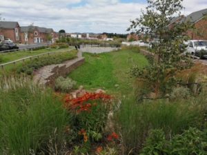
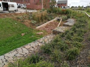
Devon Case study: Sustainable Drainage Systems – Redhayes Tithebarn Green Corridor
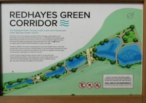
This residential development in East Devon is drained into a series of cascading attenuation basins which form a green corridor dissecting the development. During rainfall events, the basins fill up and provide storage for runoff from the roads and houses at the development.
The basins are designed to be multi-functional as they provide habitat creation benefitting local wildlife and biodiversity. Furthermore, they provide benefits to water quality with the runoff being treated as it passes through the cascading system.
This example of sustainable drainage systems (SuDS) also provides amenity value to the residents as seating areas have been installed so people can admire the open space. The green corridor cascading basins clearly fulfil all the four pillars of SuDS: water quality, water quantity, amenity and biodiversity.
In addition, signage adjacent to the basins provides engagement with the local community and opportunities for education.
National planning policy for flood risk management
The National Planning Policy Framework sets out the Government’s planning policies for England and how these are expected to be applied. The Flood risk and coastal change planning practice guidance should be followed to achieve the national policies.
The duty of local authorities and risk management authorities to cooperate in relation to the planning of sustainable development and the exercise of their flood risk management functions appears across several acts of parliament and legislation. As stated in the National Planning Policy Framework, public bodies have a duty to cooperate on planning issues that cross administrative boundaries. This particularly highlights strategic priorities such as infrastructure for flood risk and climate change mitigation. Devon has its own Duty to Cooperate Protocol.
Local planning roles in flood risk management
Local Planning Authorities (LPAs)
Local Planning Authorities (LPAs) determine minor developments where the LLFA and Environment Agency are not statutory consultees. The cumulative flood risk impact of these developments is an important consideration. They must also ensure sequential development to help steer it towards areas with low risk of flooding, as well as considering safe access and egress from sites with flood evacuation and warning plans. Online guidance is available on flood risk emergency plans for new development.
As a LLFA, DCC provides comments on surface water management proposals for new major development applications as a statutory consultee.
LPAs also prepare Local Plans to provide a strategic vision for development, addressing housing needs and other economic, social and environmental priorities. Sustainable drainage is a requirement of Local Plans in Devon and should be considered at the earliest opportunity in any development, so there is space for water and that SuDS are appropriately integrated at individual sites and strategically.
Neighbourhood planning
Neighbourhood planning is led by Town or Parish Councils and gives communities direct power to help shape development in their local area through a Neighbourhood Plan. This should meet local needs whilst aligning with strategic needs and priorities of the wider local area, including flood risk considerations.
Environment Agency
The Environment Agency is a statutory consultee on all planning applications within Flood Zones 2 and 3. They provide detailed flood risk technical advice on applications and associated Flood Risk Assessments, so that the LPA can make informed decisions. They support the LPA on the application of the national planning policy framework guidance on flood risk, coastal change and climate change. They also ensure that developments do not negatively impact Flood Defences, Main Rivers and the wider environment through the planning and permitting systems. They also provide a pre application service to developers to help avoid delays at the planning application stage.
Through their Strategic Overview role, they contribute to the product of sustainable Local Plans and development management policies, ensuring they are compatible with national flood risk strategies (e.g. Flood Risk Management Plans & Shoreline Management Plans).
Devon County Council
Devon County Council is a statutory consultee for all major planning applications in Devon regarding the provision of surface water management on and adjacent to the development site and we promote our own guidance for developers to follow, in addition to providing technical advice to LPAs to help them make informed decisions. To fulfil this role DCC has a dedicated team to review the surface water management proposals for all major planning applications ensuring they are robust and fit for purpose, in accordance with the four pillars of SuDS to reduce quantity, improve quality, provide amenity and enhance biodiversity. Outside of our statutory role, we offer a pre-application advice service, designed to streamline the application process for everyone involved.
As the LLFA, Devon County Council also contributes to the preparation of strategic planning policy, helping to embed sustainable flood risk management considerations from the start of the planning process and ensure there is a consistent flood risk message across Devon. This includes the review of
Local and Neighbourhood Plans, strategic flood risk assessments and also the influencing of policy and development management to support DCCs role as a Minerals & Waste Planning Authority.
Water and sewerage companies
Water and sewerage companies are not statutory consultees. However, the Codes for Adoption are outlined in the Water UK’s new Sewer Sector Guidance. English water and sewerage companies will be able to adopt a wide range of sewer types, including those with sustainable elements. Only certain types of SuDS components are sewers and are therefore adoptable, and so early consultation between developers and the sewerage company is recommended. In Devon this will be South West Water.
Green Infrastructure
Devon County Council promotes its own Green infrastructure Strategy (as do many individual District Councils). The guiding principles promote a joined-up approach to planning and delivery of green infrastructure across local authority boundaries as part of sustainable development delivery. Flood risk management and green infrastructure should be considered together as part of a greater emphasis on place making and design in developments, achieving multiple benefits (e.g. Garden Communities agenda).
Highway Infrastructure
The Highway Authorities (Devon County Council and Highways England) must ensure that roads are maintained in such a way so as to ensure the risk associated with surface water on the highway is kept to an acceptable level.
With an extensive network of roads and drainage within the County, Devon County Council’s highway gully cleaning strategy is based on increased frequencies for rural gullies over urban locations. In addition, those locations with known problems are also visited more frequently. See the responsibility of Highway Authorities for surface water flooding on the highway in Item 1.
New Highway Developments
As with all developments, new highway developments and schemes must adhere to planning regulation and ensure that any extra surface water generated will not increase flood risk, by providing sufficient and sustainable drainage systems.
Transport Planning and Networks
To meet the needs of the people now and in the future, the transport system must support and assist economic development and growth and enable safe, sustainable travel. The transport network must also be resilient to the future impacts of climate change at the local and strategic levels. This requires flood risk from all sources to be taken into account so that transport networks can be planned appropriately to be resilient to the increasing flood risk and key links maintained during flood conditions.
Devon County Council Highways operates a resilient network, a high priority highway network regularly reviewed to ensure connectivity across the County is maintained and resilient to impacts such as adverse weather and the increasing severity with future climate change.
Railway Infrastructure
Network Rail is responsible for maintaining the railway network across Devon and owns many flood risk assets, such as culverts, sea defences and storage lagoons. As the landowner where structures and watercourses are located, Network Rail has the responsibility to maintain these as any other riparian landowner would, keeping culverts and ditches clear so as not to increase flood risk and enable flow to freely pass through the railway embankments.
Network Rail is also a key stakeholder in the development of major flood improvements, particularly where the current and future flood risk has an impact on the railway.
Historic Assets
Devon has a large number of fine and irreplaceable heritage assets, which include two world heritage sites and two national parks. Such assets can be affected by flooding but also by the carrying out of flood improvements, Natural flood management measures, as well as hard engineered flood alleviation schemes, may directly affect some heritage assets, e.g. historic bridges, or their settings, as well as the character of wider areas, such as historic townscapes, landscapes and/or seascapes. The risk of damage to any historic asset needs to be appraised when considering flood improvement works.
Historic England has prepared guidance on flooding and historic buildings and there is other useful information on their website, including flooding and older homes and remediation. Other types of heritage assets, including archaeological sites and buried and/or waterlogged archaeological and palaeoecological resources, for example, may be affected by schemes or associated changes in hydrology. Other relevant advice may be found in The Settings of Heritage Assets (2017) and Preserving Archaeological Remains (2016), particularly Appendix 3 on Water Environment Assessment Techniques and Appendix 4 on Water Monitoring for Archaeological Sites.
Regulation of works on watercourses
Works in, or close to watercourses designated as a Main River are regulated by the Environment Agency (Main River Map) through the Flood Risk Activities Environmental Permits process. All other watercourses are classified as ordinary watercourses and these are regulated by Devon County Council as the Lead Local Flood Authority through Land Drainage Consents. Failure to obtain the relevant consent may involve a notice being served for the removal of any structure if it is deemed to increase flood risk and the legislation does not provide the opportunity for retrospective consent. Enforcement powers are also available to ensure that obstructions are removed in order to maintain a freeflow of water. These regulations under the Land Drainage Act 1991 are in place to ensure that there is no increase in flood risk and to minimise impacts on people and the environment.
As LLFA, DCC provide Land Drainage Consent to works on ordinary watercourses and have powers to maintain a free flow of water in an ordinary watercourse through enforcement. Furthermore, DCC have powers to enforce removal of any unconsented works.
Devon County Council (as do the Environment Agency) has a strict culverting policy, where they are permitted for essential access purposes only. Devon County Council has also made available good practice guidance for when working on watercourses, available as supporting documents to this strategy.
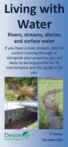
Riparian landowners, i.e. where a watercourse flows through or adjacent to their land, have duties and responsibilities to receive and pass on a flow of water in its natural state without undue interference in quantity or quality. More information is available on owning a watercourse and DCCs Living with Water leaflet. Landowners are also responsible for the drainage of surface water on their land in such a way so as to not cause nuisance to others and must accept natural land drainage from higher land.
Principle 11: Consenting to works on Ordinary Watercourses
Devon County Council will regulate works on ordinary watercourses, ensuring that any activity will not increase flood risk and will encourage sustainable measures and methods in doing so. This will be in line with the regulation of main rivers by the Environment Agency maintaining a consistent approach across Devon.
Climate change, adaptation and natural, sustainable solutions
Natural Flood Management and Sustainability
Natural Flood Management (NFM) is the implementation of nature-based solutions which help to alleviate the risk of flooding. To support this strategy DCC has produced a NFM Guidance Document for Devon, to guide and inform landowners engaged with managing flood risk. Further guidance is available online, providing information on the evidence behind NFM: Working with Natural Processes – Evidence Directory and where to find opportunities for maximising the benefits of NFM through the Working With Natural Processes mapping tool.
This strategy document not only sets out the strategy for reducing flood risk in Devon, but encourages it is done in a sustainable way that will minimise the negative impacts on the natural, built and historic environment. It also seeks to achieve wider improvements where possible, such as biodiversity gain, taking into account mitigation against the effects of climate change. Through NFM, sustainable land management, investment in natural capital and opportunities for net gain and biodiversity enhancements should be sought and delivered to achieve multiple benefits for Devon’s communities and natural environment. This is an essential part of a resilient future, as hard defences alone cannot protect us from the changes we will face this century.
Principle 12: Natural Flood Management Risk Management
Authorities will promote natural flood management measures (where appropriate) in all flood investigations and improvement projects, either as sole measures or in combination with hard engineering solutions, including supporting NFM initiatives throughout Devon. We will also promote sustainable land management which seeks reduced rates and volumes of surface runoff, erosion and sediment transport by endorsing education and awareness campaigns as part of community engagement projects.
To achieve sustainable flood risk management, an internal DCC environmental review process is followed. This will identify the likely negative and positive effects of any flood alleviation works, schemes and studies so that appropriate mitigation and enhancement measures can be incorporated into the design at an early stage. By following this process we will enhance Devon’s valuable agricultural land and incorporate its exceptional landscapes, biodiversity, cultural and historic environment and natural resources.
Devon Case study: Natural flood management – Ottery St. Mary
Working with the East Devon Catchment Partnership, DCC investigated the significant surface water flow paths that exacerbated the existing surface water and Main River flood risk within the town.
Given the significant investment by the Environment Agency in previous years to mitigate the risk from Main River flooding, the decision was made that DCC should instead focus on an approach that utilised Natural Flood Management techniques to reduce peak flow heading into the catchment.
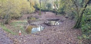
Multiple interventions were identified ranging from improvements soil husbandry, installations of leaky woody dams and re-establishing a wooded pond to not only give flood risk benefits, but also biodiversity and amenity value.
The works were completed in March 2020.
Principle 13: Sustainable Management of Local Flood Risk
We will reduce the risk of flooding to property and significant infrastructure to enable resilient economic activity that provides for communities’ needs whilst conserving, enhancing and providing access to Devon’s natural environment, green spaces, landscapes and heritage assets and demonstrating progress towards net-zero carbon emissions from LFRMS activity by 2050 to contribute to Devon’s response to the climate and environmental emergency.
Climate change and adaptation
The effects of climate change are considered to be a very high risk to the increased threat of flooding with many drainage systems and historic flood defences at risk of being overwhelmed as a result. We recognise that flood risk to property and infrastructure is increasing as a result of climate change, and will seek to proactively manage this with relevant partners, in a way that is underpinned by appropriate science; in particular catchment hydrology, the latest climate change projections and local expertise and knowledge specific to our context in Devon.
Current climate change predictions are always considered in any flood risk study or catchment modelling used to develop improved flood defences and also in our role as statutory consultee for all major planning applications. The effects of climate change are causing an increase in extreme rainfall events which is increasing the risk of overwhelming many drainage systems and historic flood defences leading to a greater risk of flooding.
Another significant effect of climate change is sea level rise due to ocean warming and the melting of land-based ice. This will have a major impact on the risk of coastal flooding and also fluvial flooding due to tide-locking for greater periods. Further information on the rate of sea level rise can also be found in the Environment Agency’s current climate change predictions webpage.
Devon County Council (along with other Devon RMAs) has declared a climate emergency and has committed to facilitating the reduction of Devon’s carbon emissions to net-zero by 2050 at the latest and has collaborated with other organisations in Devon to implement a response to the Devon Climate Emergency. Further information can be read in the Devon Carbon Plan. All flood risk activities will need to take this into consideration and design appropriate solutions to minimise the carbon footprint during construction and throughout its operation.
Principle 14: Adapting to Climate Change Devon
Risk Management Authorities will use the latest UK Climate Projections to make resilient flood risk management decisions for the effects of climate change. Where necessary difficult choices about the future protection of property and infrastructure will need to be made.
Increasing community resilience and awareness
Community resilience and engagement
With increasing flood risk and climate change predictions for the future, it is important that our communities are resilient to the resulting impacts. A resilient community should be aware of the risks and be prepared, with precautionary measures in place to limit potential damages. In terms of flood risk this could include any flood warnings or emergency plans that are aligned to the Local Strategy. Communities can help to improve their resilience by setting up local flood groups and becoming flood wardens. They must also be prepared for adapting their way of life to accommodate some impacts of future climate change and understand where tough decisions may have to be made. The Environment Agency, Devon County Council and District level Emergency Planning also have a role to support communities in raising awareness, becoming resilient and adapting for the future.

Help and guidance is available for local communities from the Devon Community Resilience Forum, which is supported by the Environment Agency, Devon County Council, Emergency Services and community members. Facilitated by the charity Devon Communities Together, the forum supports communities to build their resilience and provides a platform for professional and peer to peer support, both online and through regular forum events. The forum can assist local communities with the development of their community emergency plans; a document that guides community response in an emergency and helps them to prepare for such eventualities. A prioritised list of high-risk communities are being targeted by the forum to encourage the development of their plans. These can be led by Flood Action Groups or Parish Councils, for example and others are encouraged to contact the forum for further advice and support.
Community emergency plans
Community emergency plans are not only invaluable to local residents and groups but can also be uploaded to a secure website where they can be viewed by the emergency services. If there is an emergency in your community, they will be able to view your plan and understand how the community may already be responding, where there is high risk, and what resources the community has. View a map of current Devon communities with completed plans.
The Devon, Cornwall and Isles of Scilly Multi Agency Flood Framework sets out the principles that govern the multi-agency response to a significant flood incident. The purpose of the Framework should not be confused with the purpose of this strategy and should be used in conjunction with this document as it contains important and relevant information for an emergency flooding situation.
Devon Case Study: Community Resilience – Lympstone Flood Resilience Group

Lympstone Village is situated in East Devon on the eastern shore of the Exe Estuary. With a long history of flooding, Lympstone Flood Resilience Group was formed by existing flood wardens in 2017 due to growing concerns about the combined risk of tidal, fluvial and surface water flooding.
The Group established the Lympstone Flood Risk Management Project in 2018 with the support of the Environment Agency. The project has a Steering Group including representatives of all of the flood risk management authorities and the Parish Council, with objectives to gain a more accurate understanding of the flood risk, and ensure that appropriate and effective action is taken to minimise the risk – using a combination of prevention, protection and preparedness measures.

Progress to date includes:
- Development of an integrated hydraulic model for Lympstone (funded by the Environment Agency), completion 2021
- Investigation of surface water runoff from the rural catchment and NFM opportunities (funded by DCC and East Devon District Council’s Parishes Together and Communities Together Funds)
- Investigation of flood hotspots and working with partners to tackle the priorities
- Review of existing flood defences to strengthen them where feasible

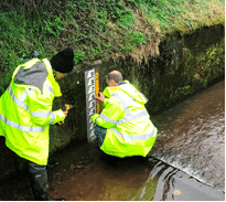
River level monitoring - Increase in the number of flood wardens (now totalling 24), and strengthening of the preparedness and response procedures
- Promoting awareness among local property developers
Key success factors of the project:
- Strong partnership approach
- Holistic strategy with a strong project plan to drive and monitor practical action
Principle 15: Raising Awareness and Improving Communication and Involvement
Through collaboration with other Risk Management Authorities and the Devon Community Resilience Forum, all Partners will work together towards raising public awareness (including those that are most vulnerable such as the elderly, young children, those living with a disability or living in areas of deprivation) about flood risk and the roles of the Risk Management Authorities, providing clear and up to date information.
Flood forecasting and warnings
Flood forecasting is undertaken by the Flood Forecasting Centre, a partnership between the Met Office and the Environment Agency. Flood guidance statements are regularly sent out to Risk Management Authorities when the risk of flooding is increased. The Multi-Agency Flood Framework details sources of flooding and how the risk of these are communicated.
In England and Wales the Environment Agency operates a flood warning service in areas at risk of flooding generally from Main Rivers or the sea. Using the latest available technology, Environment Agency staff monitor rainfall, river levels and sea conditions 24 hours a day and use this information to forecast the possibility of flooding. Find out more and sign up for flood warnings in the Devon area.
Self-help measures
In the event of a flood warning or imminent flood, property owners may find themselves in a position where action must be taken by them to defend their property. Help will not always be immediately available from the authorities and residents at risk must be prepared to put resilience measures in place to protect their homes and businesses. View flood risk maps to find out if you are at risk of flooding.
Sandbags
No authorities are responsible for the provision of sandbags, however, some District Councils and Parish or Town Councils do provide sandbags to protect homes and property. This level of service differs across the County. Details of the service available in specific areas can be found on the Devon County Council website and on individual authority websites.
It should also be noted that the Fire and Rescue Service do not have a statutory responsibility to protect property from flooding; it is the responsibility of the property owner to prepare their properties with the necessary flood resilience measures in advance of any storm event. Further guidance is available on the use of sandbags.
Property Flood Resilience (PFR)
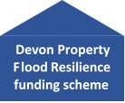
Property owners need to be proactive in obtaining resilience measures and where appropriate more robust products such as flood gates and flood doors. There are many types of these alternative products available depending on the nature of the flooding and requirements of temporary defences. Further information on these products is available from the National Flood Forum and the Blue Pages directory. For support with obtaining PFR measures on your home, DCC’s bespoke Property Flood Resilience funding scheme is available for those living in properties at risk of flooding. This scope of funding will include an initial survey of the property to identify the required resilience measures that can then be procured and installed.
Principle 16: Property Flood Resilience
When wider flood alleviation schemes for a community or individual property are not viable or able to be delivered in the foreseeable future, Risk Management Authorities will remain committed to making properties more resilient to flooding through the installation of Property Flood Resilience measures where possible.
Who to contact about flooding
Your guide on who to call:
If it is an emergency and there is danger to life as a result of flooding you should not hesitate to call 999
To report flooding of the highway and blocked drains contact Devon County Council’s Highway Customer Service Centre on 0345 155 1004 or report a problem online. Office hours are Monday to Friday 8am – 8pm and Saturdays 9am – 1pm. For emergencies outside of these hours call 0345 155 1008
For any flooding on major trunk roads (the M5 A30, A38, A35 and A303) contact the Highways Agency on 0300 123 5000 (24 hour service)
To report flooding from sewers and water pipes contact South West Water on 0344 346 2020 (24 hour service)
For enquiries about flood warnings contact the Environment Agency’s Floodline on 0345 988 1188 (24 hour service)
For general queries about Main River or flooding from the sea contact the Environment Agency on 03708 506 506, email enquiries@environment-agency.gov.uk or visit www.gov.uk/environment-agency
For all other flooding queries contact Devon County Council Flood Risk Management Team on 01392 383000 (ask for ‘flood risk’), email floodrisk@devon.gov.uk or visit www.devon.gov.uk/floodriskmanagement
Preparing for a flood:
Please refer to Devon County Council and Environment Agency web pages for advice on what to do before, during and after a flood.
In the first instance of local flooding and sandbag requests contact your local District Council or Parish Council to determine the availability of sandbags in your area.
Responding to flood events
When a flood event occurs, it is immediately followed by an emergency response and then recovery phase. There are many roles involved in this process, covered by the Emergency services, Environment Agency and local authorities. Details of this are included in the Multi-Agency Flood Framework. As LLFA, DCC’s Flood & Coastal Risk Management team becomes involved at the recovery phase, through recovery coordination, community engagement and investigation.
The response phase
The response phase encompasses the decisions and actions taken to deal with the immediate effects of an emergency. At a high level the response will be to protect life, contain and mitigate the impacts of the emergency and create the conditions for a return to normality. In many scenarios it is likely to be relatively short and to last for a matter of hours or days.
The recovery phase
The recovery phase can start at or shortly after the declaration of a major incident and may take months or even years to complete. It should be an integral part of the response from the beginning, as actions taken during the response phase can influence the longer-term outcomes for a community.
The Devon Flood Recovery Coordination Group
The Devon Flood Recovery Coordination Group may be formed during a major flood event. Once there is no longer threat to life and property and the response phase is complete, the responsibility for coordination of multi-agency recovery will transfer from the Police to a local authority. This process is detailed in the Multi-Agency Flood Framework and the Combined Agency Emergency Response Protocol. Typical members of this group are the Environment Agency, emergency services, District Councils, South West Water, Network Rail and Highways England (when disruption to the trunk road and rail network) and other utilities when appropriate. Devon County Council also has a role on the recovery group as a Category 1 Responder, Lead Local Flood Authority and Highways Authority.
Principle 17: Working with Emergency Responders
The Lead Local Flood Authority and District Councils of Devon, through their Emergency Planning services, will continue to work with Partners’ emergency responders to develop plans and provide information to inform operational decisions in support of a Devon that is resilient to flooding.
Post flood event community engagement
Following any flood event, we will engage with relevant District Councils, Risk Management Authorities, local Parish and Town Councils and community members to gather information. This information is shared with other agencies to determine the extent of impact.
Information within the community is critical to understanding the cause and impact of any flood event, therefore it is essential to liaise closely with the local community to gather all of this data. This is sometimes gathered through local community events where members of the public can ‘drop in’ to supply details on flooded properties.
Anyone with details of flood events can submit their information anytime via the Flood Online Reporting Tool.
Investigating flood events
Gathering information on flood events is important so that we can build up a picture of flood risk in Devon and determine the causes and possible solutions. As an LLFA DCC have a duty to investigate significant flood events. For those flood events that reach our significance thresholds in Item 4 investigation reports and recommended actions will be published on our website. These reports together with an accurate database of flood events across Devon assists us with prioritising and investing in flood risk management measures. See Part 2 and Part 3 of this strategy for more details.
LLFA’s must carry out flood investigations following significant flood events.
Principle 18: Recording and Investigating Flood Events
Devon County Council in partnership with the Environment Agency will record local flood incidents reported through Risk Management Authorities and the public in order to build up a picture of risk for current and future work. Those that reach Devon’s significance thresholds will be investigated under Section 19 of the Flood and Water Management Act and the reports will be published online.
Item 4. Flooding significance thresholds
Investigation reports under Section 19 of the Flood and Water Management Act will be considered by DCC for events with a significance threshold level of:
- 5 or more residential properties internally flooded (in one area, e.g. one street)
- 2 or more commercial properties internally flooded.
- Critical infrastructure affected (e.g. roads or rail links closed).
- Critical services affected.
OR if the above criteria are not met:
- History of repeated flooding. The frequency of flooding greater than 3 occurrences of internal property flooding within 5 years or similar frequency felt to be significant.
- The incident is part of a widespread flood event.
- The vulnerable are particularly at risk, such as the elderly, young children, those living with a disability or living in areas of deprivation.
- Significant negative impact on the natural environment.
Reviewing the strategy
Parts 1 and 2 of this strategy document will be reviewed in line with the National Flood and Coastal Erosion Risk Management Strategy and 6 year investment cycle. Therefore, it is anticipated that this document will be reviewed in 2027. We will maintain this strategy throughout the 6 year period to ensure the embedded links and signposting are to the most up to date and relevant guidance/policies. Part 3 of this strategy, the Action Plan will be continually updated as priorities and funding opportunities change and improvements are delivered, most likely on an annual basis.
Performance evaluation
In order to measure the performance of flood risk management in Devon and the effectiveness of this Strategy, the Action Plan will be monitored. Progress can be measured by monitoring the number of properties that are no longer in areas classed as at high risk or those that are at lower risk than before, as a result of flood alleviation measures put in place as recommended in the Action Plan.
Since the first publication of our Local Strategy in 2014, flood risk management measures implemented as a result of our investment program and action plan, have resulted in the reduction in flood risk to over 750 properties from schemes delivered by DCC and a further 6124 properties where DCC have provided significant financial contributions towards schemes delivered by others. In addition to this, over 80 community emergency plans have been registered and uploaded to the Devon Community Resilience Forum.
Part 2: Priority Communities and Investment – What will we do and how?
How communities are prioritised
Prioritising communities at risk of flooding for investment is a challenging task for Devon as there are many more communities at risk of flooding than can be realistically reviewed during the next funding period. Flooding is very stressful to all concerned, causing significant mental health but we need to be realistic in what can be delivered and manage expectations. There are a number of factors that must be considered, which need to be carefully balanced with potential opportunities, such as working in partnership with others to realign programmes and maximise funding sources.
We use a GIS tool (Figure 3) to analyse our spatial flood risk data and assess the vulnerability to flooding of Parish and Town areas, following the prioritisation criteria in Item 5. This high level analysis provides an indicative level of risk, which can then be considered by DCCs Flood and Coastal Risk Management team alongside local knowledge and ‘quick win’ opportunities.
This process drives the compilation of the priority communities identified in this part of the strategy and furthermore to the action plan in Part 3. It will be continually reviewed and updated to account for any significant incidents, greater knowledge and additional funding opportunities, enabling other communities to be considered during this period.
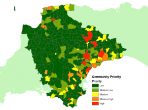
Item 5. Criteria used for GIS analysis to prioritise communities and Devon’s Local Flood Risk Management Strategy Action Plan.
- Number of properties affected or at high risk in any one community
- Frequency of flooding to that community
- Depth/Severity of flooding experienced or at high risk
- Risk to life (particularly the vulnerable such as the elderly, young children, those living with a disability or in areas of deprivation)
- Impact on, or high risk of disruption to critical infrastructure
- Impact on, or high risk of disruption to businesses and services, especially services such as health, education, emergency services
- Impact on, or high risk of impact on the Environment
- Sufficient Cost-Benefit ratio and robust business case.
The specific order of the criteria does not reflect the weighting attached to each. In particular, the risk to life is shown beneath three other criteria as it is directly influenced by them.
Prioritisation is subject to change as a result of any new data on flooding events.
This is an ongoing assessment and will always consider the most up to date climate change and sea level allowances as part of supporting modelling information.
Devon’s priority communities
Devon’s priority communities, listed in Table 3 below and on our online map, are to be considered for investigation and potential investment over the next 6 years. The annual action plan of investment is covered in Part 3 of this strategy. This prioritised list is indicative of the current situation and may however, be subject to change, depending on further flood events, greater catchment knowledge, changes in funding levels and opportunities for aligning with other Risk Management Authority or key stakeholder programmes and/or other funding initiatives.
It should also be noted that other Devon communities, not included here, may be known to have significant flood risk but from a source managed by another RMA. For example, the Environment Agency would carry out investigations and improvement works for a community at risk of flooding from the sea or a main river, such as Bishop’s Tawton. Other communities not listed will be continually assessed following any notable incidents and may be considered.
These priority communities are Devon’s highest priorities as the LLFA and this section needs to be read in conjunction with the South West Flood Risk Management Plan (FRMP) which will outline the priorities of all other RMAs in the South West. Our priority community list will inform the FRMP and database which sits at a River Basin Management Plan level.
Table 3. Devon’s priority community list*
| Priority | Community | Source of flood risk to be addressed | Potential partner authorities | Flood Risk Area in South West Flood Risk Management Plan |
|---|---|---|---|---|
| High | Barnstaple | surface water | North Devon Council, DCC Highways, South West Water (SWW), Environment Agency (EA) | Flood Risk Area |
| High | Exeter | surface water | Exeter City Council, South West Water (SWW), Network Rail (NR), Environment Agency (EA) | Flood Risk Area |
| High | Kingsbridge | surface water | South Hams District Council (SHDC), SWW, EA | |
| High | Tiverton | surface water | Mid Devon District Council (MDDC), SWW, EA | Flood Risk Area |
| High | Dawlish | surface water | Teignbridge DC, SWW, EA | Flood Risk Area |
| Medium high | Teignmouth | surface water | Teignbridge DC, SWW, NR, EA | |
| Medium high | Exmouth | surface water | East Devon District Council (EDDC), SWW, EA | Flood Risk Area |
| Medium high | Newton Abbot | surface water | Teignbridge DC, SWW, EA | Flood Risk Area |
| Medium high | Seaton | surface water | EDDC, EA | |
| Medium high | Kingsteignton | surface water | Teignbridge DC, SWW | |
| Medium high | Totnes | surface water | SHDC, SWW, EA | |
| Medium high | Bideford | surface water | Torridge DC, SWW, EA | |
| Medium high | Ilfracombe | surface water | North Devon Council, SWW, EA | Flood Risk Area |
| Medium high | Budleigh Salterton | surface water ordinary watercourse | EDDC, EA | |
| Medium high | Sidmouth | surface water | EDDC, SWW | |
| Medium | Crediton | surface water | MDDC, SWW | |
| Medium | Okehampton | surface water | West Devon Borough Council, SWW |
* This list is not exhaustive and only shows the prioritised communities with a medium to high level of risk within the LLFA’s remit of flooding from groundwater, surface water and ordinary watercourse. Other sources of flooding will be managed and prioritised by the relevant authority, as detailed in Item 1. Small scale works and flood schemes may also be taken forward in other communities, not listed above, if opportunities arise.
Economic analysis of Devon’s priority communities
Following the review undertaken in our GIS flood risk analysis tool and the resulting priority communities currently identified in Table 3, we will then undertake a high level economic analysis to identify the potential level of economic damages that would result from a flood event, as well as the potential level of central government funding that could be sought from Defra’s Flood Defence Grant in Aid fund to help develop and deliver the works.
The outcomes of this will determine the level of investigation that can be justified as part of a potential scheme whilst considering cost benefit implications and management of expectations within the community at risk.
For example; if it’s determined that a specific location is unlikely to generate significant levels of central government funding, then we may decide to undertake a smaller desktop study with the potential of maximizing local funding opportunities to progress the scheme delivery in-house to ensure that costs are kept to an acceptable level as to not negatively impact the cost benefit of the potential works.
If it is decided through the initial economic analysis that significant external funding could be made available to support a larger scheme, then we will engage with specialist consultants to investigate and model the source of risk, as well as identify potential options to mitigate the risk, with the process being project managed by FRM staff.
Once a viable, cost effective and beneficial solution has been identified a business case is produced and submitted in line with Treasury and Defra requirements for RMA business case templates. Success at this stage will result in the project being progressed to construction and delivery.
Measures for delivering local flood risk management
For our priority communities, a wide range of measures should be considered that best manage the risk in the short, medium and longer term. Collaborative working should be encouraged between Risk Management Authorities, aligning programmes to maximise funding opportunities.
Possible flood risk management measures will generally fall into one of the categories below in Item 6, where the general hierarchy listed shows how these measures should be approached. The hierarchy follows the principles of starting with increasing a community’s preparedness for flooding and increasing resilience, through to implementing physical flood defence measures.
Resilience is fundamental for all communities, to manage local flood risk and be prepared for future climate change impacts. The physical measures should prioritise more sustainable natural processes in the first instance, either as sole measures or in combination with hard engineered solutions. Hard engineering measures should be considered when natural solutions alone will not adequately protect a community to the required level. All these measures combined will seek to enhance the natural environment and local economy and help build community resilience.
Item 6. Flood risk management measures hierarchy
Being prepared and increasing resilience for all Devon communities
Community resilience measures:
Engaging with communities directly and through the Devon Community Resilience Forum to raise awareness of flood risk and encourage the setting up of local flood action groups and development of emergency plans to increase resilience. These measures should always be a part of any community at risk, even when other interventions are in place.
Emergency planning measures:
Flood warnings and flood action plans can be used to improve community preparedness and resilience to flooding. Support from the Devon Community Resilience Forum is available for communities.
Riparian landowner maintenance:
Members of the public who own land adjacent to watercourses have riparian responsibilities and therefore a duty to maintain their section of watercourse to ensure there is no impediment of flow. See DCC’s guide ‘Living with Water
Making Policy:
Policies can be made to direct spatial planning or to set standards for development that will help reduce further flood risk.
Measures and actions in Devon’s high risk communities
Natural Flood Management measures:
Implementation of natural measures which help to alleviate the risk of flooding to property and significant infrastructure, either as sole measures or in combination with hard engineering solutions. Managing water in the upper catchments will help to reduce and slow the flows downstream minimising the risk to property and the level of any hard engineering defences that may be required.
Retrofitting Sustainable Drainage Systems:
Installation of sustainable drainage systems in urban areas to manage surface water and remove it from traditional piped drainage systems.
Delivery of early intervention schemes:
A solution that can be implemented relatively quickly by the Risk Management Authorities or Local Authority at relatively low cost.
Community action:
Some cases can be successful when community groups join forces and deliver and maintain their own local schemes. In some cases this may generate further contributions from local levy or the Lead Local Flood Authority.
Further investigation/research:
Further investigations such as catchment studies and hydrological/hydraulic assessments to understand the flow rates and directional paths and evaluate the extent of flooding. These would provide evidence for future capital investment.
Development of future schemes:
Where immediate action is not financially viable or a solution not readily available then a larger scale flood alleviation scheme may be required. In such cases national funding would need to be secured together with additional contributions from others, such as local levy, local authorities and other third parties. This is likely to require hard engineered improvements, however Natural Flood Management measures must also be considered and delivered where possible.
Property Flood Resilience:
Resilience measures at a property level such as flood doors, gates and air bricks can be installed to increase the resilience of individual homes and businesses. This option is often chosen as the last line of defence where any potential for a larger flood alleviation scheme will not be viable or delivered in the foreseeable future.
Devon Case study: Modbury flood alleviation scheme

Following significant flooding of Modbury in 2012, DCC set out to investigate the sources of flooding and subsequently identifying solutions to reduce the flood risk. Working with our strategic partner South West Water, a hydraulic model was produced to investigate the risk of surface water, watercourse and sewer flooding.
Working within Defra’s Flood Defence Grant in Aid funding formula, DCC developed a scheme that would benefit the community from all three sources of flood risk. The scheme consisted of three large earth dams, interception ditches and improvements to the highway drainage network.
The scheme constructed in 2018/19 is now fully operational and gives a standard of protection to 80 residential and commercial properties against the 1 in 100 year flood event.
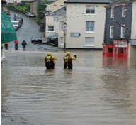
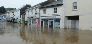
Part 3: Annual action plan: What, when and where?
Once communities are prioritised and funding is either secured or being sourced, areas of investment, such as investigation, design or scheme delivery that are to be progressed will be recorded on Devon’s Action Plan which accompanies this Strategy, thus providing a holistic view of the current and ongoing investment programme for Devon.
The strategy’s annual Action Plan will be continually developed to highlight the improvement works currently being progressed by DCC. It will consider measures listed in Part 2, from catchment wide schemes and studies down to individual property flood resilience measures. All works will be carried out in accordance with the Principles and Objectives of this Local Strategy.
View Devon’s Annual Action Plan tables and map
Part 4: Supporting documents
In addition to this main strategy document, there are several supporting documents which provide more information, including Devon’s priority communities and action plan for Part’s 2 and 3, statutory assessments to go alongside this strategy and Devon County Council best practice guidance and policies for flood risk management activities.
- Action plan
- Devon’s priority communities (interactive map)
- Strategic Environmental Assessment
- Habitat Regulations Assessment HRA
- Equality impact assessment – EIA
- Natural flood management guidance
- Land management guidance
- Managing land to reduce flood risk – guidance leaflet
- Sustainable Drainage Systems: Guidance for Devon
- Devon County Council culvert policy
Working on ordinary watercourses good practice guidance: