Contents
1. Introduction
As flood events in the UK become more extreme and frequent as a result of climate change, the social, economic and environmental costs are ever-increasing. Devon is no exception to this trend and is a county that often experiences high-intensity storms and floods. The history of flood events in Devon ranges from large countywide storms to more regular localised flooding. Sources are varied – flooding can originate from major rivers, the sea, surface water, groundwater or minor watercourses, sometimes with multiple sources simultaneously contributing to one overall flood event. Taking into account the variation in the sources of flood risk in Devon, a combination of mitigation techniques are also required in order to effectively manage flood risk.
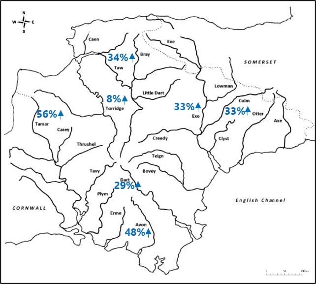
Figure 1 demonstrates the increase in peak flows across Devon in the last 50 years. With this consistent rise in the increase in peak flow across the county, the ever-increasing need to find new ways to store and slow this water should be recognised.
The 2010 Flood and Water Management Act was introduced to establish a flood risk management strategy for England and Wales. This legislation states that “maintaining or restoring natural processes” is a way of managing flood risk whilst promoting the idea that softer and more natural approaches can be a more sustainable option, offering multiple wider benefits. These concepts are echoed in the Devon Local Flood Risk Management Strategy 2021-2027, key principles include NFM being considered in all projects, either as sole measures or in combination with hard engineering solutions.
The Climate Emergency was a motion passed in parliament to promote the importance of tackling climate change. It recognises the devastating impact of worsening extreme weather conditions and calls for more ambitious targets to reduce the disastrous consequences for natural systems on which we rely on.
The purpose of this guidance
This guidance is designed to provide a summary of relevant information on Natural Flood Management (NFM) specifically tailored to Devon. It does not aim to rewrite existing documents but will signpost the reader towards these should further information be required.
This is an introductory guidance document and if you require further information please follow the links that are provided or contact any of the organisations listed in the useful contacts chapter.
Who is this document aimed at?
This guidance is intended for use primarily by landowners, land managers, agricultural and land management advisors and communities. It is to support individuals interested in resolving flood problems and managing land in a more productive way, specifically for those with no previous experience in delivering better land management or are new to working with Natural Flood Management techniques.
2. What is NFM
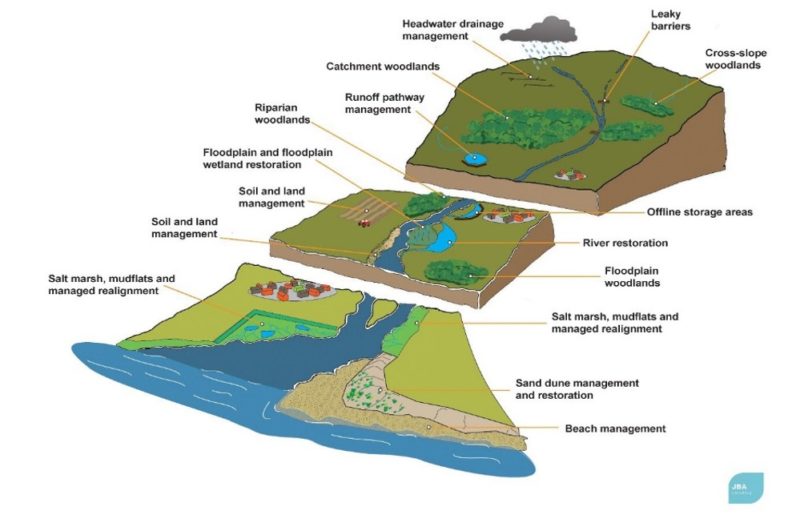
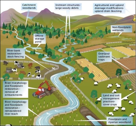
Natural Flood Management (NFM) is the implementation of natural features and actions which help to alleviate the risk of flooding. The techniques involved in NFM are primarily focused on increasing infiltration, storing water and slowing down flows. These work best when a catchment-based approach is taken, looking at the river as a whole and how flood risk can be managed up and downstream. Figure 2 demonstrated this by showing where measures can be located in each of the different parts of the river. NFM can take many forms so selecting the right technique(s) is essential in providing the maximum benefit. NFM measures can also have other environmental benefits, including (but not limited to) ecology and carbon storage.
The type of Flood Risk will guide towards the best NFM features to consider. For example, If the flood risk is as a result of field runoff the most appropriate measures would likely be different than if the problem results from water storage issues further upstream. It is also worth keeping in mind what can be realistically achieved in the available landscape.
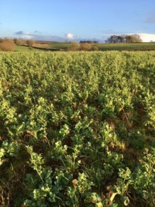
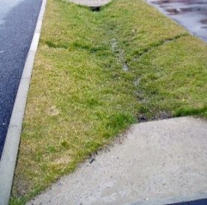
“Rural” does not automatically mean that land is naturally functioning. Intense agricultural use compacting the soil of the rural landscape means that rainfall runoff has a very similar response to concrete. In Devon this is one of the biggest issues that has exacerbated flooding, the stripping of topsoil, compaction and capping have all increased the amount of surface water runoff entering rivers or channels directly into build up areas as overland flow. By targeting this there is an opportunity to reduce risk to those who live and work with the potential of flooding.
The science and understanding behind NFM is still developing. The full benefits and the best design and construction for each scenario are still being determined through a number of evidence gathering exercises. The evidence for NFM is varied with some measures more extensively researched, and therefore possessing a more substantial evidence base for their flood risk benefits. The Environment Agency has produced the Working With Natural Processes (WWNP) evidence directory. WWNP aims to protect, restore and emulate the natural functions of catchments, floodplains, rivers and the coast so should be considered which thinking about NFM intervention.
NFM measures may never completely replace traditional engineering techniques (such as flood walls) but are designed to complement them as an effective tool in reducing the risk of flooding. NFM is also beneficial in locations where hard engineering is not a viable option for reasons such as larger cost and scale associated with hard engineering. NFM is best used by combining different measures in order to provide a greater betterment to flood risk and the wider environment. Using the right combination can reduce the depth of flooding and the duration of flood events. It is worth noting that as well as having many agricultural benefits, the negatives for agriculture are short lived. Implemented correctly, NFM features and land adjacent to rivers will likely be underwater for very short periods of time and not for months. Land will therefore function most of the time as it does currently.
Devon is a county prided for its natural beauty, heritage and landscape; with 93% of land area being rural including five Areas of Outstanding Natural Beauty (AONBs), 2 National Parks, 256 Sites of Special Scientific Interest (SSSIs) and 819 km of coastline. These environmental designations and features highlight the importance of managing flooding, as naturally as possible to fit in with the natural feel of the county. There have already been many successful NFM projects implemented in Devon.
The 25 Year Environment Plan puts weight on the importance of expanding the use of NFM and promoting practical solutions for local implementation. Within Devon, NFM can be undertaken anywhere, there are many different types and methods of NFM ranging from better land practice to small scale in river attenuation features, to wider catchment management. There should therefore be something suitable for all landscapes and environments.
High Water Common Ground is a good introductory video for NFM which communities most affected by flooding, examines the needs of the parties involved, and explores some of the most innovative methods of flood risk management using real examples from around the country.
Chapter 5 focuses on the most frequently used methods but is certainly not an exhaustive list of NFM measures that can be implemented. A combination of these approaches, locally adapted and site-specific will always provide the greatest potential.
3. Multiple benefits of NFM
Aside from flood alleviation, NFM can have a wide host of other benefits. These include:
Land Productivity
Land productivity can be improved through better farming practices. Improved soil structure and a reduction in the loss of nutrient rich topsoil creates economic benefits for farmers and landowners. By reducing compaction, capping and waterlogging of the ground farmland can be used for more months of the year. Health of livestock can also be improved by increasing shelter and shade associated with tree planting.
Water Quality
Water quality can be improved through a number of NFM mechanisms that help to manage diffuse pollution. Methods such as reconnected floodplains and swales allow organic sediment and topsoil high in fertilisers and pesticides to accumulate and settle out of the flow. Wetlands also help to remove excess nutrients from the system. Woodland creation and improved land practices can stabilise soils and reduce erosion, which in turn reduces sedimentation and pollution of watercourses.
Carbon Offset
As many companies strive towards carbon neutral targets a way to achieve this is by offsetting used carbon through adopting NFM measures such as soil management, woodland creation and floodplain reconnection which reduce the amount of CO2 emissions in order to compensate for emissions made elsewhere. Carbon offset does not have to be done by the company who is releasing these emissions, the company can benefit by funding the work to be done by communities/individuals and claiming back the carbon offset.
Biodiversity
NFM measures can be beneficial for entire river systems. Wildlife benefits from the creation of new habitats such as wetlands and woodlands, particularly where these link up existing habitats and therefore improve connectivity across landscapes. Measures which reduce topsoil entering watercourses will benefit river ecosystems e.g. through preventing the siltation of fish spawning beds and keeping pollutants such as fertilisers and pesticides out of the river system.
Climate
Benefits to climate can be realised through an increase in carbon storage. Floodplains, wetlands and woodland creation act as carbon sinks effective in accumulating and storing carbon. The effects of drought are reduced, as healthy soil retains water for longer during dry periods. As well as providing effective carbon storage, NFM helps build resilience to the impacts of a changing climate including urban cooling.
4. Local Consideration
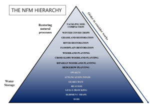
4.1 NFM Hierarchy
The NFM hierarchy gives a general order of some of the common measures in terms of how natural they are as a flood alleviation measure, first focusing on restoring natural processes and then looking at other ways of storing and slowing water. This should be taken as a guide only as in some instances it may not be suitable or possible to follow the hierarchy (for example, if the land does not have a watercourse running through or if there is a restriction on tree planting e.g. on areas of existing ecological value).
The most natural NFM features are those that focus on improved land management, tackle soil compaction and restore the land to how it would have naturally functioned prior to intensified agricultural practices. Any NFM construction should be both made of natural materials and look and act like how the natural landscape would e.g. leaky dams should be created from locally felled trees and logs and not from planks of wood. NFM measures that provide storage for high watercourse flows or high surface water runoff volumes are less natural than simply using better management practices or tree planting but are nevertheless effective components and can all be implemented in a natural way.
Taking an integrated approach to land management that considers NFM systemically and at source is considerably more effective than trying to retrospectively tackle run-off and build-up of water once it becomes an issue.
4.2 Catchment Setting
As well as following the hierarchy it is also important to consider setting when selecting the most appropriate NFM measures. Thinking about NFM over a whole catchment can help produce the greatest benefits for flood risk alleviation.
As water travels through the catchment, runoff issues need to be addressed along the watercourse and at source, not just where they build up to become a flood risk. Headwaters can play an essential role in providing flood control as the majority of the total running water network is made up of headwater streams. Sometimes flood risk may not be a problem in the headwater areas, however it is the processes that go on here that can exacerbate problems downstream when the headwater tributaries combine to form main rivers. With increasing agricultural and development pressure the natural drainage and hydrology is changing which is why it is more important than ever to be thinking of the whole catchment.
The majority of NFM interventions can be carried out anywhere within the catchment, but please be aware that some NFM features should only be implemented in the headwaters; leaky dams which work so well in small streams would not be stable in main rivers and would have an increased risk of logs washing out in the larger flows.
The effectiveness of NFM within the catchment depends also on the extent to which they are used. Wide scale implementation in a small catchment will gain the largest improvements; larger catchments require more interventions in order to make an impact upon flood risk.
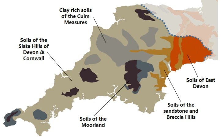
4.3 Soil Types
Soil types can have a big role to play in selecting the most appropriate NFM measure. The ability and potential for soils to store water and reduce runoff are often not utilised to their full potential. The five main soil types in Devon are listed below.
Soils of the Sandstone and Breccia Hills have a high risk of soil erosion which can contribute towards the silting up of river systems. Therefore, crop cover throughout the year is essential. Non-inversion tillage to prevent capping is also beneficial and building organic matter can improve soil stability and reduce the risk of capping. There are also opportunities to create wetlands to slow and store flows.
Soils of East Devon are slowly draining. Subsoiling can improve this downward drainage and grassland management can help to produce good soil structure. The wet soil in valley bottoms can support wetland creation which can slow runoff.
Clay Rich Soils of the Culm Measures are at high-risk of soil compaction and are often waterlogged over winter. Timely grazing and subsoiling can prevent this soil compaction. The correct crop choice is important as is manure/slurry spreading during dry weather only. There are many opportunities to create wetlands to slow runoff on these soils.
Soils of the Slate Hills are well-drained soils. When growing high-risk crops temporary filter fences can be used to slow runoff and trap sediment. Ditches can be created to divert runoff into lower-risk areas. Grassland strips and woodland can be planted in valley bottoms where conditions are unsuitable for cropping.
Soils of the Moorland are soils developed on impermeable deposits and can remain waterlogged for long periods of time. Woodland creation is possible on steep slopes with freely draining soil. Heather moorland restoration can be encouraged by reduced grazing, reseeding and soil restructuring. Drainage ditches blocked with dams to slow down runoff can create wetland habitats.
4.4 Environmental Designations
Please use Devon County Council’s Environment Viewer to check whether your land is within an environmental designation (as listed below-other designations may apply).
If your land is in any of these areas, please get in contact with the relevant authority for advice on environmental considerations that might be specific to your area. They may also be able to assist in selecting the best NFM for you and suggesting funding opportunities.
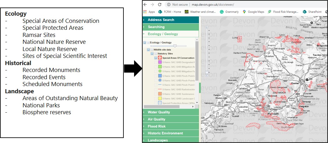
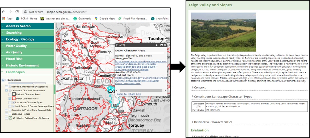
Landscape Character Assessments are a good way to ensure the NFM you are considering fits in with your local area.
Find what “Devon Character Area” your land is in on the DCC Environment Viewer then navigate to more information on this area on Devon’s landscape character assessment website
5. NFM Features
5.1 Resilient Catchment Tools
The Environment Agency is in the process of developing some Natural Flood Management tools that have been designed to be used in conjunction with this document. These tools will help the user identify the most beneficial locations in a river catchment to promote NFM, and also to help demonstrate the best type of measure to employ in a given location.
The tools will consist of:
- A suite of prioritisation maps, showing where NFM could take place within a river catchment to have the greatest reduction on flood risk
- A suite of maps to show where potential conflicts with promoting NFM measures may exist, i.e. how easy it will be in a given location
- A calculator to enable the user to see a before and after hydrograph of the river catchment and natural capital valuation to demonstrate the scale of benefit that could be seen by implementing NFM measures.
These tools have currently had a trial phase completed on the River Otter catchment and a catchment in Cornwall upstream of Perranporth. It is hoped that the final tools will be available for the entirety of Devon, free of charge, in summer 2021.
Example maps from the trial phase of the tool are shown below.
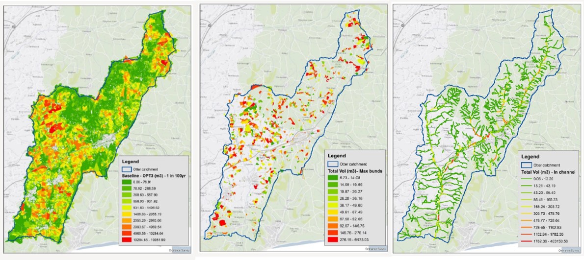
These maps show, from left to right, areas where runoff reduction, flow pathway and in-channel NFM measures may be sighted to the greatest effect, with the highest impact areas coloured red and the lowest green.
The categories in the tool are the same as those set out in this document to aid the user in cross referencing the type of NFM features these maps could represent against this guide for further advice on implementation. An update to this section of this document will be provided once the final suite of tools are available.
5.2 NFM Features: Run-off
“Land runoff interventions have focused on soil management and land use measures”
Tackling Soil Compaction
CAN IMPLEMENT WITH MINIMAL FURTHER ADVICE
“Alleviation of soil compaction to increase permeability of land for infiltration”

High livestock densities and the movement of heavy farm machinery are two of the main mechanisms that lead to soil compaction, which forms a solid impermeable layer. When soil is compacted it can greatly increase surface water runoff compared to healthy and aerated soil. The additional water that originally would have infiltrated into the ground builds up, increasing flood risk with the potential to create waterlogged and poached conditions on farmland, reducing land productivity. To match the right solution to each problem it is advised that landowners seek professional advice before undertaking certain soil remediation work. Timing and ground conditions are key to consider to avoid further harm, a long-term change in land use will be required to remove the pressure that caused the compaction in the first place.
NFM Benefits
- Reducing compaction is one of the most effective techniques for reducing overland flow.
- Improves connectivity with groundwater and promotes groundwater recharge which will reduce the volume of water entering the watercourses.
- Increases the quantity of water stored in the soil.
Agricultural Benefits
- Soil aeration increases land productivity by promoting better soil structure, reducing soil loss and poaching
- Improved movement of air and nutrients through the soil profile.
- Promotes root growth and therefore more efficient crop growth.
- Increased fertiliser uptake, therefore, a reduction in fertiliser use.
- Easier access through a reduction in waterlogged areas.
- Improved water quality by reducing runoff and soil loss into streams.
- More infiltration takes place, therefore less scorching of grass happens in warmer months as there’s a greater access to water for the root network.
Methods
- Aerating the soil by mechanically using spiked aerators, chisel ploughing, subsoiler or sward lifters (depending on land use and compaction depth).
- Timing needs to be carefully considered as carrying out these tasks in wet or very dry conditions can cause significant problems
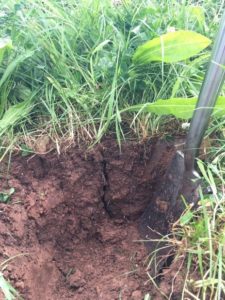
- To identify soil compaction, dig a soil pit and assess the condition of the soil and depth of compaction.
- Raising soil pH to target indices can improve soil structure and aeration as well as productivity
- Avoid the use of heavy machinery on wet soil as this will increase compaction.
- Manage crop and livestock rotations to reduce compaction and increase product yield.
- If re-seeding or over-seeding, consider a seed mix with diverse rooting depths
- Seasonal livestock management and rotations.
- In the weeks after mechanical intervention, soils are vulnerable to slumping and compaction. To prevent damage, avoid grazing or trafficking for some time afterwards
- Always assess depth and severity of compaction before carrying out mechanical intervention to choose the appropriate method.
Location
- Any field that suffers from soil compaction can be managed to reduce the problem.
- Fields used for winter grazing are highly vulnerable.
Environmental Considerations
- Using spiked aerators, subsoiler or sward lifters can be particularly damaging for surface and below ground level archaeology.
Policy and Legislation
- Generally, no consents required but worth contacting Devon County Council Historic Environments Team if using subsoilers and are concerned that there may be impact on sub surface archelogy.
Maintenance
- Ongoing best practice is needed to retain good soil structure
More Information
Winter Cover Crops
CAN IMPLEMENT WITH MINIMAL FURTHER ADVICE
“Non-cash crops grown on land that would otherwise be left bare over winter.”
Unvegetated agricultural ground leaves valuable topsoil vulnerable to erosion and capping. The purpose of winter cover crops is to protect the soil surface, promote infiltration and support good soil structure and rooting which helps stabilise degraded soils over the winter months when run-off and associated erosion is at its highest.
If cover crops are dug in after winter this will help to build nutrients and organic matter reserves in the soil which will in turn improve the resilience and productivity of the land.
Winter cover crops must be established early enough and weather conditions should be suitable, putting down a seedbed late in the season or during poor weather could cause a lot of runoff and leave soil bare and vulnerable to erosion, exacerbating a problem that was hoped to be reduced.
NFM Benefits
- Cover crops reduce overland flow by increasing infiltration rates.
- With soil stabilised by vegetation cover less sediment runs off into rivers, maintaining channel capacity.
- Well established cover crops with good vegetative cover intercept rainfall and protect the soil surface which reduces capping and therefore the amount of surface runoff
Agricultural Benefits
- Soil erosion and subsequent loss of nutrients via runoff is reduced.
- Improved soil health, higher nutrient content and soil structure, improving productivity and crop yields
- Can help to fix nitrogen in the soil and reduce fertiliser costs.
- There is a reduced need for herbicides and pesticides.
- Planting helps to conserve soil moisture which is beneficial in times of drought.
- Less opportunity for weeds to establish on bare soil.
Methods
- Plant crops that can grow throughout the winter months, select species that establish quickly to achieve good cover and to minimise soil loss by erosion. Consider rooting depths and have a diverse seed mix.
- Do not remove winter crop cover before immediate establishment of spring crop.
- incorporate winter crop in to increase organic content in the soil.
- If the aim is to improve soil structure chose a crop with a long taproot.
- Compaction will need to be removed with mechanical operations before establishing the cover crop. Once compaction is removed, the cover crop should support good soil structure.
- It is essential that cover crops are established when soil conditions are sufficiently dry not to cause soil degradation by inappropriate time of operations.
- Important to establish crops early enough to achieve successful establishment. Both these situations are likely to be early autumn – note that the harvest prior to establishment therefore needs to be at a suitably early time.
Location
- Plant on land vulnerable to erosion such as sloping fields.
- Benefits are greatest where runoff currently flows freely during periods of heavy rainfall.
Environmental Considerations
- Plants with long tap roots should not be used on archaeological sites. Consider other crops.
Maintenance
- Can be used repeatedly as part of an arable rotation long term strategy
More Information
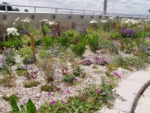
Grassland Restoration
CAN IMPLEMENT WITH MINIMAL FURTHER ADVICE
“Converting improved grassland back to traditional unimproved grassland.”
There are three main types of grassland; acid, neutral and calcareous. The majority of Devon’s grassland is improved pasture on neutral or slightly acidic soils. Only a tiny proportion is “unimproved” grassland. Unimproved grassland is considered to have a greater water holding capacity than improved. Extensively farmed grassland can also slow water flow down through the rough nature of the ground.
Within Devon, the majority of the remaining unimproved grassland is either purple moor grass mire or rhos pasture. These are types of ‘Culm grassland’ – wet, species-rich grassland overlying the Culm measures.
NFM Benefits
- Unimproved grassland has a greater water storage capacity than intensively farmed grassland.
- Moor-grass and rush pasture slow runoff, thereby reducing peak flood flows.
- Suspended sediment load in runoff is reduced before it enters the watercourse.
- Surface water flow pathways are broken up and lengthened by the tussocky nature of the grassland.
Agricultural Benefits
- Better soil structure and soil health
- Creates a habitat to encourage wildlife diversity
- Unimproved grassland has a greater ability to filter pollutants from runoff (including fertilisers and pesticides).
- Can be beneficial for animal health, providing a greater variety of nutrients.
Methods
- Think about alleviating any soil compaction prior to restoration to maximise the infiltration benefits that grassland restoration can provide
- Grassland and wildflower seeds should be harvested from the local area to encourage growth of vegetation native to the area.
- A seed bed should be created in late summer or early Autumn. This can be achieved by harrowing, e.g. with a power harrow when the sward is short (5 cm).
- Seed should be spread very soon after creation of the seed bed. This can be carried out using a quad-towed fertiliser spreader or by hand on small sites.
- Quantity of seed required depends on target species. Typically 10 – 25 kg / ha is used.
- Sheep grazing in the first winter after seed spreading is essential to keep grasses already present from smothering the new seedlings. Sheep should be removed at the end of February, when the sward should be around 2 cm long.
- Hay making in late summer in the first years after spreading wildflower seeds helps wildflower species to become established.
- Haymaking should be followed by aftermath cattle grazing in September and October to encourage grassland restoration implement sympathetic grazing programs
- Methods used should take careful account of soil conditions.
- On wet sites light machinery should be used for ground preparation and to spread seeds to minimise the risk of soil compaction.
Locations
- Best results on sites of low nutrient, i.e. those that have not received heavy inputs of slurry or fertiliser. To restore sites that have received heavy inputs, several years of silage making with no further inputs should be used to lower nutrient levels before seed spreading takes place.
Environmental Considerations
- Implement on moorland landscapes valued for their aesthetic qualities and wildlife value
- Do not damage habitat of high value in attempting to carry out this work
Policy and Legislations
- Local seed harvesting may require permission and licencing.
- Sites in countryside stewardship may need permission to carry out this work
- Higher Tier countryside stewardship funding may be able to fund this type of work
Maintenance
- Where conditions allow, a late summer hay cut followed by aftermath grazing is ideal for at least two years after spreading seeds.
- Long-term management is through grazing
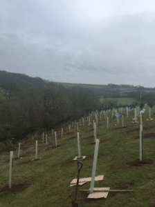
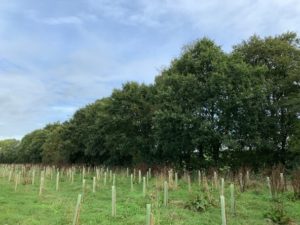
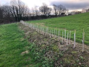
Woodland Creation
CAN IMPLEMENT WITH MINIMAL FURTHER ADVICE
“Promoting soil permeability and flow interception to reduce and slow flood flows.”
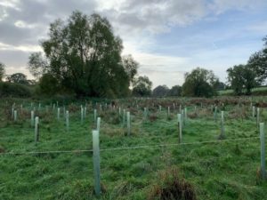
Woodland creation improves soil infiltration beneath the woodland area and can reduce soil erosion and the resulting sedimentation of watercourses. Flood waters are also slowed when they reach wooded areas through an increase in the “roughness” of the ground and the trees.
Waterlogged sites or sites suffering from compaction can often benefit the most from woodland planting, especially when using tree species with deep root systems. However, it is still important to consider soil type when selecting appropriate woodland species and also whether infiltration can be improved by improving soil health and aeration prior to planting.
NFM Benefits
- Soil infiltration is improved. Infiltration in woodlands can be much greater than grazed pasture, as soil compaction is alleviated. With an increase in infiltration, the volume of floodwater is reduced.
- Reduced erosion and sedimentation ensure that maximum watercourse capacity is retained.
- Surface water runoff is slowed during flow through woodland undergrowth. Planting on overland flow routes provides water interception benefits.
- Trees are efficient at intercepting rainfall with conifers intercepting a higher volume than broadleaf. Conifers also offer interception in the winter months when broadleaf trees are bare.
Agricultural Benefits
- Trees provide both shelter and shade for livestock. Grazing areas sheltered by trees increase pasture growth.
- There is a reduction in floodwater damage to productive farmland.
- Woodlands trap and filter field runoff, preventing fertiliser and topsoil loss. This prevents these materials from entering the watercourse.
- An increase in infiltration promotes groundwater recharge.
Methods
- Consider tackling soil compaction issues prior to planting to maximise infiltration potential.
- Woodland can be created through planting, direct seeding or through allowing natural regeneration- although the latter may take decades.
- New woodland requires careful siting and design that takes into account environmental and other considerations. The approach should comply with the UK Forestry Standard (UKFS) and take opportunities to deliver multiple environmental benefits, such as enhancing biodiversity, improving water quality, and increasing carbon storage to combat climate change.
- Before trees are fully developed, they may need guards or fencing off to protect young plants. These guards can be removed once trees are established.
- Mixed broadleaf trees are particularly effective in intercepting runoff and taking up water from the soil. Plant native species similar to those in surrounding areas, as these will give an indication of the trees the soil and geology will cater for.
- Trees should be planted roughly 2m apart for the creation of new woodland. These could be managed and once established, thinned to accommodate for growth. Undergrowth development is encouraged.
- Weeds should be removed for the first 5 years while newly planted woodland establishes.
Location
- Throughout the catchment. Of most benefit on sites vulnerable to waterlogging and compaction.
Environmental Considerations
- Aim for the siting and design of new woodlands to complement the distinctive character, special qualities and valued attributes of the landscape, particularly in National Parks and Areas of Outstanding Natural Beauty. Landscapes particularly sensitive to woodland creation include those whose open expansive character are noted as valued special qualities, and where woodland would obscure iconic or historic designed views. Refer to local Landscape Character Assessments and Management Plans published for each National Park and AONB.
- Avoid planting over Scheduled Monuments, Registered Parks & Gardens, within the curtilage of Listed Buildings and in fields that are unenclosed and enclosed medieval strip fields –check for ‘Strip Fields’; and ‘Medieval Strip Enclosures’. Refer to DCC Environment Viewer under ‘historic environment’. Other relatively intact medieval field systems are also sensitive ‘Medieval Enclosures Based on Strip Fields’; ‘Medieval Enclosures’ (e.g. assarts) but it is the boundaries themselves that are the important element, so protecting those from encroachment/scrubbing out would be the issue. Planting stands within a field may still be o
- Ensure that woodland creation does not result in the loss of existing wildlife habitat such as species rich grassland or wetlands, heathland or rough grasslands (especially on steep slopes) which provide feeding grounds for species such as Barn Owl and bats or habitats for ground nesting birds. Please obtain advice before planting as many of these areas will not have been designated.
Policy and Legislation
- An Environmental Impact Assessment (EIA) may be required depending on the environmental sensitivity of the location and the scale of proposed woodland creation. Seek guidance from the Forestry Commission.
Maintenance
- Important to carry out essential maintenance of newly planted saplings for the first 5 years, including weed control, checking and securing stakes and guards, maintenance of protective fencing, and control of pests and diseases.
- Woodlands should be managed sustainably in accordance with the UKFS.
More Information
Cross Slope Tree Planting
CAN IMPLEMENT WITH MINIMAL FURTHER ADVICE
“Creation of a shelter/buffer layer on a slope to intercept downslope runoff”
Trees planted on slopes along the contour of the land help to intercept downslope runoff and overland flow routes. Interception not only traps and stores some of this runoff, but flows are also slowed and the presence of trees promotes infiltration.
Cross slope planting can happen on a small scale and does not necessarily reduce the amount of productive land area. It can also help to stabilise slopes vulnerable to heavy erosion and by doing so, also reduces slope erosion through a reduction in surface water runoff.
Please refer to “Woodland Creation” on page 15 for further advice.
NFM Benefits
- Cross slope interception helps to slow down surface water runoff and reduce the water volume passed downstream through the catchment.
- Infiltration is increased as trees aerate the soil and take up water from the system.
- Tree roots help to stabilise slopes to reduce erosion and subsequent sedimentation of watercourses.
Agricultural Benefits
- Trees provide shelter and shade for livestock. Areas sheltered by trees also increase pasture growth.
- Reducing surface water runoff consequently reduces flood water damage to productive farmland.
- Woodlands trap and filter field runoff, preventing fertiliser and topsoil loss and from these materials entering into the watercourse.
Methods
- Plant across the slope, along the contour of the land.
- Undergrowth development should be especially encouraged to provide maximum surface water interception.
Location
- Where runoff flows directly over slopes, causing overland sheet flow.
- Where there is a receiving watercourse at the foot of the slope.
Environmental Considerations
- Be cautious applying on slopes distinctly lacking in woodland where public access offers open views.
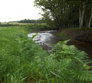
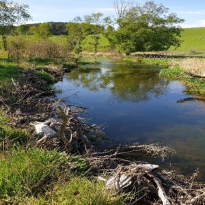
Riparian Woodland Creation
CAN IMPLEMENT WITH MINIMAL FURTHER ADVICE
“Narrow strip of land adjoining a river channel on either side”
Riparian woodland can hold back and slow down flood flows within the watercourse but can also control bank erosion and sediment deposition. They act as “buffer zones” along the channel. Riparian woodland can provide woody debris which can either maintain built leaky dams or can form natural ones which will also help to delay downstream flood flows.
Riparian woodland helps prevent land adjacent to the watercourse from becoming inundated with water during flood events, preventing damage and helping to maintain the productivity of the land.
Please refer to “Woodland Creation” on page 15 for further advice.
NFM Benefits
- Soil infiltration is improved.
- Reduced erosion levels mean that maximum watercourse capacity is retained.
- The riparian woodland strip acts as a buffer to hold back water to prevent river overflow becoming runoff and a flood issue downstream.
- Surface water runoff is slowed therefore decreasing flood peak downstream.
- Bankside trees stabilise the banks of the watercourse, preventing erosion and siltation.
Agricultural Benefits
- Shade and shelter are provided for livestock.
- Woodland acts as a buffer for sediment, fertilisers and pesticides entering the watercourse.
- Reduces watercourse management as bank work and silt removal will need to be undertaken less often.
- Reduces the effect of spray drift coming off fields.
- Reduces the risk of livestock getting waterborne diseases.
Methods
- The strips of woodland should be roughly 5m wide on either side of the channel.
- To maximise the slowing of runoff plant shrubs such as hawthorn, hazel and alder with trees such as willow and birch combined.
- Due to proximity to the watercourse fertilisers should not be used.
- Undergrowth development should be encouraged.
- Weeds should be removed for the first 3 years while newly planted woodland establishes.
Location
- Along rivers and streams which flow through fields or where watercourses are situated adjacent to field boundaries.
Environmental Considerations
- Be aware that planting could increase the amount of organic matter (e.g. leaf fall) entering a watercourse.
Policy and Legislation
- If fencing is post and rail/post and wire, then an environmental permit will not be required. Wire mesh should be at least 100mm spaced.
More Information
- Keeping Rivers Cool’ in the face of climate change and rising temperatures.
- Woodland Trust Tree Planting Advice
Hedgerow Planting
CAN IMPLEMENT WITH MINIMAL FURTHER ADVICE
“Creating and restoring hedgerows that naturally divide land”
Hedgerows have the NFM function of intercepting and slowing overland flow. This increased interception promotes infiltration as well trapping, storing and slowing runoff. These NFM benefits can be achieved by planting across slopes (interception of downslope flow) or by restoring existing hedgerows.
Alongside flood management benefits, hedgerows also provide shelter for livestock and enhance biodiversity potential through improving wildlife corridors.
Hedgebanks are a key feature of Devon hedges and offer considerable value to flood alleviation but also all other multiple benefits. Wherever possible create hedgebanks for planting onto and where existing hedgebanks are eroded or collapsed then cast-up and re-plant.
NFM Benefits
- Hedgerows can intercept surface water runoff and promote infiltration, preventing water from reaching rivers and increasing flow downstream.
- Interception also helps to slow down runoff, especially when planted across slopes.
- Sediment trapped when surface water reaches hedgerows reduces sedimentation and pollution of downstream watercourses.
Agricultural Benefits
- When water is trapped and filtered, nutrients contained in the sediment are prevented from washing off the land.
- Increased shade and shelter for livestock.
- Hedgerows create shelter from wind thereby reducing soil erosion and limiting erosion pathways.
- Animal contact across fields is prevented, thus reducing the spread of disease.
- Habitat creation for wildlife is enhanced.
Methods
- Plant species-rich native broadleaf appropriate to site. Consider a mix of species to enhance habitat diversity and plant native species similar to those in surrounding hedges.
- Before a hedgerow is fully developed, it may need fencing off to protect young plants. Remove guards once plants are established.
- Link new hedgerows to existing hedgerows to increase connectivity for wildlife.
- It is good practice to plant on a hedgebank, this gives the maximum flood management benefits
- Plant in 2 staggered rows 40cm apart, approximately 6 plants a meter.
- Remove weeds until the hedge is fully developed.
- Looking at historic maps could give you an idea of where to site hedges effectively and sensitively.
- Look for opportunities to reinforce existing or reinstate historic boundaries/field patterns.
Location
- Plant hedgerows at sites where they were once located but subsequently removed. Restore existing hedges which have become degraded.
- Consider planting across slope where runoff is conveyed in high volumes during heavy rainfall.
Environmental Considerations
- Include in agricultural landscapes where key characteristics include hedges and hedgebanks and in degraded agricultural landscapes that have suffered field boundary loss.
- Avoid hedgerow planting in unenclosed landscapes valued for their open expansive character.
Policy and Legislation
- Hedgerow Regulations 1997.
Maintenance
- While plants are establishing annual maintenance is required.
- Laying hedges every 8-15 years ensures a thick hedge that will ensure livestock barriers remain intact.
More Information
Sediment Traps
SEEK FURTHER ADVICE BEFORE IMPLEMENTATION
“The settling out of sediment from flow before water is discharged”
Sediment traps come in the form of shallow trenches or basins that are deeper on the downside. On sloping fields these are sometimes constructed in conjunction with bunds. The temporary impoundment of water in the silt trap allows sediment to settle out of suspension which is then filtered further when it passes through the outflow.
The aim of sediment traps is not to store large volumes of water but to prevent the sedimentation of water storage features such as ponds, ditches and watercourses. If storage capacity in these features is compromised from sediment build-up, then flood risk will increase.
NFM Benefits
- When siltation of rivers is reduced, watercourse capacity downstream is maintained.
- Can be used in combination with other NFM measures such as ponds and basins to reduce maintenance costs and prolonging the lifespan of NFM measures.
- Minor amounts of water are stored.
Agricultural Benefits
- Topsoil that has been trapped can be re-spread, reducing loss of both soil and accompanying nutrients.
- Water quality is improved.
- Capacity of ditches and watercourses are retained reducing the need for clearance of built-up sediment.
- Reduces maintenance costs and improved longevity of other NFM features.
Methods
- Size and number of traps required depends on the volume of runoff and amount of sediment vulnerable to erosion.
- The shape of the silt trap will be determined by the direction/s of flow pathways being intercepted.
- Silt traps should gently slope to a deeper area in which the outflow pipe will sit at the deepest point.
- The soil that is excavated can be used to form a bund or could be spread evenly over the land.
- If a bund is constructed it should be less than 1.3m and extend beyond the edges of the trap to ensure water is directed into it.
- Small, vegetated excavations form the trap, usually with a gravel outlet and rocks around this to form protection from erosion.
- For clearance an access point is essential.
Location
- Use in conjunction with other NFM measures as a pre-treatment area.
- In areas of high runoff where sedimentation is a problem.
- In the proximity of ditches into which water would naturally discharge.
Environmental Considerations
- Can implement on flat or gently sloping landscapes that can accommodate ponds or ditches without need for significant modification of topography. Can also be used in the urban environment.
Policy and Legislation
- If connected to an ordinary watercourse then a Land Drainage Consent may be required from Devon County Council. For main rivers an Environmental Permit may be required from the Environment Agency.
- U10 waste exemption is needed from EA to spread silt on agricultural land.
- a bund is created to increase storage capacity, this may be subject to an abstraction or impoundment licence.
Maintenance
- Check silt levels regularly, especially after high rainfall events.
More Information
5.3 NFM Features: In-Channel
“In channel interventions focus on reducing flow velocities within channel and enhancing floodplain inundation”
River Restoration
SEEK FURTHER ADVICE BEFORE IMPLEMENTATION
“Reinstatement of natural physical processes and features in a river”
River restoration is the reinstatement of rivers to their more natural and original state. To increase the land available for agriculture and development many river channels have been altered and straightened or have simply degraded over time reducing river capacity and changing flow conditions.
Removing man made obstructions from the watercourse, altering the river shape, introducing sediment and adding wood are ways of restoring the river. Restoration for flood risk purposes is most effective when implemented in areas of high erosion, so suitable bank protection works are crucial in river restoration.
NFM Benefits
- Stable banks mean reduced sedimentation and therefore more capacity within the watercourse.
- Adding meanders into the channel helps to slow the flow of the water, provides storage, encourages sediment deposition and slows water travelling downstream as it has to pass over longer distances.
- Removing concrete channels and revegetating banks increases roughness and slows flow of the water.
- Restoring collapsed banks in a natural way reduces water overflowing onto surrounding land.
Agricultural Benefits
- Reduced risk of bank erosion and failure.
- If embankments are removed water can quickly drain back into rivers.
- Rich wildlife habitat and improved fish populations
- Restoring and raising the bed of the watercourse where goyles have formed slows the heavy erosion of valuable land.
Methods
- Leave rivers to adjust naturally by removing lateral constraints and man-made obstructions.
- Installation of stock fencing to prevent channel banks being damaged by livestock. The recommended minimum distance is 2m from the river.
- Where rivers have been previously canalised, historic aerial imagery or historic Ordnance Survey maps can be used to identify the previous natural form.
- Dimensions are site-specific.
Location
- There should be no increased risk to property or infrastructure from an altered river course.
- Ideally, the landowner should own both sides of the watercourse channel.
- Small streams in the upper catchments are easier to restore than main rivers.
- If the river channel s owned by landowners on either side then a plan should be mutually agreed.
Environmental Considerations
- Please talk to the EA when considering any river restoration to ensure compliance with environmental legislation including protected sites and protected or rare species (otters, bats, nesting birds, fish, invertebrates) and to avoid spreading invasive species
- Caution when implementing on historically designed riverbanks and designated heritage assets.
Policy and Legislation
- Work within a watercourse may require a Land Drainage Consent from Devon County Council or an Environmental Permit from the Environment Agency (if an ordinary watercourse or a Main River respectively).
Maintenance
- Once the river is restored to its natural form the channel should need little maintenance.
More Information
- Westcountry Rivers Trust have information on river restoration and the projects they are involved in.
Floodplain Reconnection
SEEK FURTHER ADVICE BEFORE IMPLEMENTATION
“Restoration of the hydrological connection between rivers and floodplains”
As rivers are straightened and embankments built up, floodplains are disconnected from the natural channel thereby reducing the area that is available to store floodwater. Without this area storing water during times of flooding, a greater volume of water travels downstream potentially putting local areas at a higher risk of flooding.
If water can enter the floodplains then this provides an additional storage area during potential flood events, flooding undeveloped and unproductive land areas.
NFM Benefits
- Large amounts of water can be stored on the floodplain. If this water can infiltrate into the ground or be discharged at a controlled rate back into the river, then a decrease in water volume will prevent build-up and flooding downstream.
Agricultural Benefits
- Allowing for low energy flooding onto the floodplain reduces the risk of bank erosion and failure.
- Floodwater contains nutrients and sediment that, if deposited, can provide more fertile land.
- Most floodplains are still available for grazing for most of the year.
Methods
- Removal of flood embankments and other barriers.
- woodland planting on the floodplain will stabilise the ground and increase floodplain roughness.
- Inlets and outlets of the floodplain need to be considered to avoid fish entrapment.
- Where earth is moved ensure grass is planted to avoid erosion and sedimentation.
- Bund features can be constructed to store more water if storage from reconnection alone is not enough.
- Plan for restoration of vegetation over exposed areas of bare earth as soon as possible. Use appropriate species-rich, deep rooting grass species as well as trees. Wetland, pond-side and emergent species mixes are available as well as specific mixes for different geologies and situation.
Location
- Flat or gently sloping land adjacent to watercourses with natural low spots.
- Land with low productivity where compaction can be avoided where possible.
- Away from properties and developed areas.
- Opportunity to restore where historic water meadows and wetlands on valley floors where these have been lost, or where remnant wetlands are characteristic and valued. These can be identified from aerial imagery and historic OS Maps, see DCC’s Environment Viewer.
Environmental Considerations
- Avoid introducing new visible earthworks in landscapes whose distinctive natural topography is a valued attribute and where there is little scope to blend the features into the landscape.
- Flood plans can be of huge ecological value. Please get professional advice from the EA or another source before undertaking flood plain restoration, including tree planting, to ensure compliance with environmental legislation including protected and priority habitats and protected or rare and to avoid spreading invasive species + ensure that the proposals provide maximum ecological benefit.
Policy and Legislation
- If connected to an ordinary watercourse then a Land Drainage Consent may be required from Devon County Council. For main rivers an Environmental Permit may be required from the Environment Agency.
Maintenance
- Once floodplain is reconnected little maintenance is required.
- Inlets and outlets should be cleared when needed.
More information
Beavers
SEEK FURTHER ADVICE BEFORE IMPLEMENTATION
“Introduction of beavers to promote the growth of wetland habitats”
Introducing beavers into the natural environment allows them to construct dams across watercourses and develop natural wetland habitats, thereby slowing the flow and increasing the water storage capabilities of the catchment. The dam features that beavers create not only hold back and slow the flow, but also encourage natural reconnection of the floodplain. This allows for water to spill out and disperse onto the land to then be drained back into the watercourse once levels subside or to infiltrate into the ground.
Unlike the construction of leaky dams, the structure of beaver dams is harder to regulate. If beavers are to be introduced a location, then the wider area should be considered as beavers can travel large distances for territory.
Introduction of Beavers can only be done with the correct licences and is currently only done as part of specially regulated projects. Beavers can be released into fenced areas or openly into the environment. It is easier to get a licence for fenced beavers, but the benefits can be seen more widely, and beaver populations behave in a more natural way if released openly.
NFM Benefits
- Leaky dams allow for water to build up during high flows to reduce the amount of water entering the downstream network.
- The speed of the flow will be reduced thus reducing the flood peak.
Agricultural Benefits
- Can reduce localised flooding of the surrounding land.
- Dams will also trap sediment and improve water quality.
Location
- Introduce beavers away from human populations
- Beavers will move about if not fenced so consideration of surrounding area is important especially if near to urban developments.
Environmental Considerations
- Beavers don’t eat fish so there are no concerns about fish species or stocks.
Policy and Legislation
- Beavers cannot currently be released without a licence which can be obtained by Natural England.
Maintenance
- Dams will need checking on a semi-regular basis to ensure structures are still secure and anchored in place. Clearance of additional debris and sediment will ensure storage area is maintained and prevent overflow.
- Regulating the spread of beaver territories is also important.
More information
- River Otter Beaver Trial Science and Evidence Report
- Guidance on reintroducing species into the wild
5.4 NFM Features: Flow Pathways
“Flow pathway interventions focus on runoff attenuation features”
Swales
CAN IMPLEMENT WITH MINIMAL FURTHER ADVICE
“Shallow open channels used to convey runoff in a controlled way”
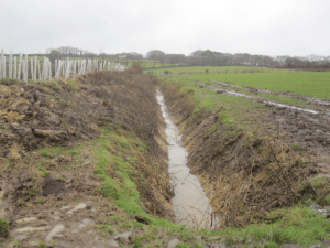
Swales can be used to collect runoff from fields to convey and redirect water in a controlled way to a point of discharge. These are vegetated features which can slow the flow of water and serve as infiltration points, reducing the quantity of water reaching watercourseS.
Swales also allow for sediment to settle out of flow and therefore provide water quality benefits.
Swales can be standalone components or can be created alongside ponds and basins with runoff being discharged into these outlet points.
NFM Benefits
- Swales increase water storage areas and infiltration.
- Runoff rates are reduced by slowing the flow of water within the swale.
- Swales can act as a sediment trap to capture that which would otherwise build up and reduce capacity in watercourses.
- Swales slow discharge into a watercourse and restrict peak flow downstream.
Agricultural Benefits
- By controlling where water is conveyed soil loss and subsequent loss of organic matter is reduced.
- If water is diverted into swales, scour in other locations is reduced.
- Sediment that settles in swales reduces the amount of sediment and nutrient pollutants reaching the watercourse. This can then be dug out and respreads.
Methods
- Swales are unlined to allow for infiltration. Vegetate the swale channel with dense, deep rooting vegetation to bind soil and prevent erosion.
- Soil compaction should be alleviated within the swale to promote infiltration. This can be achieved by removing the top 300mm of soil and replacing with a blend of topsoil and sand.
- Swales should have a maximum 1 in 3 side slope for safety and maintenance purposes.
- Swale depth is generally between 400-600mm.
- Check dams can be included within swales to further slow the velocity of the water.
Location
- Swales should be located along field boundaries and at the base of shallow slopes prone to overland flow.
- Implement where there is a high level of sedimentation from field runoff.
Environmental Considerations
- Can be implemented within the urban landscape and on flat or gently sloping natural landscapes that can accommodate ponds or ditches without need for significant modification of topography.
- Avoid on areas where significant modification of the natural topography would be required and where the natural landform contributes to the special qualities or distinctive character of an area.
Policy and Legislation
- If the swale is on the floodplain of a main river an Environmental Permit may be required from the Environment Agency.
Maintenance
- Vegetation should be cut regularly to maintain storage volume within the swale.
- Any inlets/outlets should be monitored and cleared if blocked.
- If check dams are installed, these will require maintenance to provide longevity.
More Information
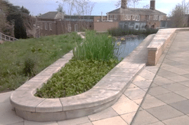
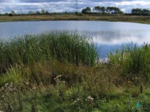
Attenuation Storage Ponds
SEEK FURTHER ADVICE BEFORE IMPLEMENTATION
“Areas of floodplain adapted to capture and retain overland runoff in a managed way”
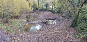
Offline attenuation ponds are located on the floodplain, online ponds have a watercourse running directly through them. Flood water in these is temporarily stored and released in a controlled way.
Attenuation ponds can be used to store peak flows but also act to intercept surface water runoff. Offline storage areas usually require the construction of a containment bund to separate the area from the main watercourse. Between flood events, offline areas may be dry so if this NFM measure has been selected to incorporate biodiversity benefits in addition to that of flood risk, a compromise may need to be made between maximum storage capacity (area will sometimes be dry) or less storage but a constant volume/depth of water (improved habitat opportunities). Ponds can be designed to retain a water level all year-round creating wildlife benefits for the land.
NFM Benefits
- Provides an area for water to be stored during heavy flow conditions. The water will drain from the pond slowly once runoff volume subsides.
- Water can infiltrate back into the ground reducing the volume of water in the network.
Agricultural Benefits
- Sediment can settle out of the flow, helping to maintain the capacity of the watercourse. This sediment can be returned to the land.
- Water retention can be beneficial in times of drought.
- Water quality can be improved by incorporating a silt trap into the pond.
- Can be used to reinstate old dew ponds
Methods
- For ponds to be effective as flood alleviation there must be additional storage area above the normal water level that will be used in times of heavy rainfall and flooding.
- May requires construction of a retainment bund which (for stability not greater than 1m in height).
- Ponds may require set inlets and outlets to divert water in and out of the pond.
- A network of smaller ponds can provide a greater benefit than one large pond.
- Can be constructed on floodplains to provide additional flood storage.
- Consider groundwater levels. A pond liner may be required if levels are high.
- An armoured spillway stops erosion if the pond is overtopped.
Location
- Effective in the mid-catchment near to watercourses on non-productive land.
- At the bottom of slopes or the corner of fields.
Environmental Considerations
- Use caution when proposing bunds on valley floors that have flat natural topography and open expansive views with a lack of features that help integrate the necessary artificial contaminant bunds into the natural landscape.
- Ensure that pond creation does not result in the loss of existing wildlife habitat such as species rich grassland or wetlands, heathland or rough grasslands
Policy and Legislations
- If connected to an ordinary watercourse then a Land Drainage Consent may be required from Devon County Council. For main rivers an Environmental Permit may be required from the Environment Agency.
- Ponds of a certain size or involving engineered embankments may require planning permission. Guidance should be sought from individual Local Planning Authorities.
Maintenance
- Sediment and vegetation build-up may require removal.
- Over time, scour of inlets and outlets should be addressed.
More Information
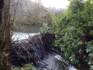
Leaky Dams
SEEK FURTHER ADVICE BEFORE IMPLEMENTATION
“Pieces of wood installed in channel, river corridor or floodplain to manage water”
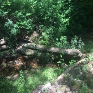
Leaky dams are designed to slow down flow velocities and create more storage for water in smaller watercourses. Once implemented, they naturally trap and build-up woody debris while allowing for fish passage to be maintained through a continuous baseflow.
There are different ways of constructing and anchoring leaky dams. The dams themselves can be constructed from lots of smaller woody debris built up, or alternatively, singular larger logs usually constructed in an X shape within the channel. Anchoring the dams is important to ensure the longevity of the dam. This can happen by securing posts in the stream and bank, planting living willow or anchoring against existing trees. Hinge felling trees into the watercourse is another way of creating the dam and keeping the log secured in place.
NFM Benefits
- Leaky dams allow for water to build-up during high flows to reduce the amount of water entering the downstream network.
- The speed of the flow will be reduced thus reducing the flood peak.
- Leaky dams are likely to increase localised flooding around the dams but decrease flooding downstream.
Agricultural Benefits
- Dams will trap sediment and improve water quality.
Methods
- • A series of leaky dams along a continuous stretch of watercourse improves the benefits that they can deliver.
- Baseflow should always be retained to allow for unobstructed fish passage. This should be at least 2X the maximum diameter of bed load (headwaters with large boulders will require a greater clearance under the logs than that with just gravel).
- Logs must be securely anchored in place.
- The lengths of the logs used should be twice the width of the watercourse to avoid them being washed out under fast flowing conditions. These also act as “flow spreaders”, conveying water onto the banksides.
- Leaky dams should have around 40% porosity which prevents silt build up and helps with fish passage while still allowing for useful construction of flow.
Location
- These structures are best suited for small watercourses in the upper catchments in streams typically less than 2m wide.
- Meanders and sites directly up or downstream of a tributary should be avoided.
- Best to implement in unproductive sites that are often naturally wet and can be temporarily flooded.
- Areas where there is a natural supply of wood and trees that logs can be anchored against are desirable.
Environmental Considerations
- Caution when implementing in registered historic designed landscapes, parks and gardens with a manicured character.
- Important to retain baseflow conditions are uninterrupted for fish passage.
Policy and Legislation
- If connected to an ordinary watercourse then a Land Drainage Consent may be required from Devon County Council. For main rivers an Environmental Permit may be required from the Environment Agency.
Maintenance
- Dams will need checking on a semi-regular basis to ensure logs are still secure and anchored in place. Clearance of additional debris and sediment will ensure storage area is maintained and prevent overflow.
Gully Blocking
CAN IMPLEMENT WITH MINIMAL FURTHER ADVICE
“The blocking up of drainage channels to slow flows and improve water storage”
Gullies that form in the headwater (upper) part of the river system and on moorland, lower the water table by discharging into watercourses at a higher rate. If water does not flow down gullies it is more likely to infiltrate into the ground and be stored on the moorland itself, thereby reducing the risk of flooding downstream.
Generally, gullies are blocked by creating dam like features within the channels which help to store water, re-wetten the moorland soil and reduce surface water runoff flowing quickly downslope.
There is potential to modify how water acts through changing stormwater runoff generation, runoff pathways and catchment storage.
NFM Benefits
- Gully blocking increases water storage and promotes infiltration.
- Reduces runoff flowing quickly downslope and into watercourses.
- Soil erosion is reduced by reducing the speed and energy of the water flow.
- Restores blanket bogs and wetland areas, thus storing more water on the moorland.
Agricultural Benefits
- A reduction in the effects of drought and moorland wildfires.
- The blocking of deep gullies can reduce hazards to livestock.
- With greater infiltration, groundwater recharge will take place.
- Moor and peatland habitat restoration.
Methods
- The size and depth of the gully will determine how many bunds/blockages should be put in place.
- Blocking gullies can be achieved through placing heather bales, rock piles or less natural wooden structures into the gullies. The best method depends on ground conditions and angle of slope.
- The base of the upstream dam should be at least level with the top of the downstream dam. This stops overflowing water from hitting the ground and undercutting the foot of the dam.
- Research has shown that blockage heights should be around 25-45cm high.
- If the gullies are long then it is recommended that the gully blocking is constructed initially at the head of the gully system and work downslope.
Location
- Blocking is particularly beneficial when implemented in the headwaters of drained moorland.
- Target gullies that are actively eroding.
- In areas used for livestock grazing.
Maintenance
- Minimal maintenance is required
More Information
- Grips and Gully Blocking factsheet including useful diagram on dam spacing
Sustainable Drainage Systems (SuDS)
SEEK FURTHER ADVICE BEFORE IMPLEMENTATION
“Creating sustainable drainage within the urban environment”
It is often difficult to implement traditional NFM measures in towns and cities. SuDS are typically used in modern developments but can also be retrofitted into existing areas create a more sustainable and controlled drainage system, instead of the usual uncontrolled runoff that urban impermeable areas create.
Detention/infiltration basins and ponds, green roofs, swales and rain gardens are all measures that store and release excess surface water runoff in a natural way. These mechanisms of managing surface water helps to minimise the risk of flooding compared to traditional piped systems. Such green infrastructure also provides multiple other benefits to people and nature in the urban environment.
NFM Benefits
- Promoting natural drainage and reduced runoff from impermeable areas.
- Slows and attenuates water before it enters the watercourse or sewer network.
- Reduces the amount of impermeable area, thereby reducing the volume of runoff.
- SuDS that allow for infiltration reduce runoff and the amount of water in the system.
Urban Benefits
- Manages water quality through settlement or biological breakdown of pollutants.
- Increases the biodiversity of urban areas by creating/promoting more natural, green areas.
- Promotes wellbeing and amenity opportunities. Creates visually attractive areas of the town/city.
- Improves air quality by buffering poor air and filtering some pollutants.
Methods
- Methods depend on the type of SuDS being retrofitted.
- Land is of higher value within the urban environment, so the cost of implementing different SuDS measures should be considered.
Location
- On land that will not be used for development – this can even be small corridors between buildings.
- Designed into open spaces to give additional amenity and biodiversity benefit.
Policy and Legislation
- Will depend on what SuDS system is being used
Maintenance
- A maintenance schedule should be implemented for each SuDS feature.
More Information
5.5 A combined approach – NFM measures that work well together
To achieve maximum benefits from implementing NFM measures, it is often good to look at undertaking or installing several NFM measures in conjunction with each other or having several of the same component within the same area. The list below suggests just a few examples of where measures can be used in combination with each other but is by no means an exhaustive list.
Leaky Dams, Riparian woodland planting and River Restoration
Leaky dams work well as part of river restoration as velocity of water is slowed, thereby reducing vulnerability to erosion. Riparian woodland gives a natural supply of woody debris that can build-up in the stream over time to replenish leaky dams.
Sediment traps, Ponds/basins and Swales
One of the main maintenance actions for ponds, basins and swales is for regular removal of sediment. In areas where sediment runoff is high, sediment traps can be implemented to improve the longevity of other measures.
Gully blocking and Grassland management
Gully blocking and grassland management are both forms of NFM that are effective on moorland areas.
River Restoration and Floodplain restoration
River and floodplain restoration are often used in combination, as both aim to restore a natural hydrological regime.
Soil aeration and Winter cover crops
These measures directly target poor soil quality involving compaction and sediment runoff issues. By aerating the soil and then giving it protection during the winter months from a cover crop, land productivity can be greatly improved.
Swales, Offline storage ponds, Sediment traps
Swales can collect runoff from land and transport it in a controlled way into offline storage ponds, which can store water during times of heavy rainfall and high flow. Sediment traps can filter the water entering the watercourse system to prevent sedimentation.
Woodland planting, Hedgerow planting, Soil aeration
On sloping sites where runoff is exaggerated a significant issue due to a steep land gradient planting cross slope woodland and hedges along field boundaries will slow runoff and help to keep valuable topsoil on the fields.
Soil aeration, Winter cover crops and Leaky dams
By improving the soil conditions and creating in-stream water storage structures (leaky dams) there will be reduced and slowed runoff both getting into watercourses and travelling down through the catchment as surface water runoff.
5.6 NFM in the Urban Environment
Some of the traditional NFM measures are not suited for built-up urban areas. However, Sustainable Drainage Systems (SuDS) can be retrofitted into existing urban areas to create a betterment for surface water runoff conditions and reduce flood risk in areas with large amounts of impermeable ground.
The opportunity to retrofit SuDS can be included as part of other changes that are happening within the urban environment such as repairing, refurbishing or replacing structures or regenerating run-down areas. SuDS often bring green areas into the urban environment and can create spaces that are visually improved with greater amenity.
Detention Basins/Infiltration Basins
Normally dry outside of storm events. They are designed to store runoff and reduce the volume of surface water.

Attenuation Ponds
As well as storing water from storm events they support native vegetation and provide habitat and amenity places for local wildlife and communities respectively.
Swales
Shallow, open channels designed to convey, treat and store surface water runoff from rainfall events.
Green Roofs
Multi-layered system that can store water which can be reused for non-potable uses. They also insulate buildings, reduce energy and water costs and have biodiversity benefits.
Rain Gardens
Vegetation planted in a small depression designed to temporarily hold and soak in rainwater runoff that flows from roofs, driveways, patios or lawns.
Further Information
- CIRIA SuDS Manual
- Sustainable Drainage Systems: Guidance for Devon
- Trees in our towns – The role of trees and woodland in managing urban water quality and quantity
- Susdrain – Recourses and information for delivering SuDS
6. Monitoring, Mapping and Modelling
6.1 Monitoring
Monitoring can either be visual observations or data collection, both are valuable tools to identify suitable locations for NFM and any potential issues early on. Careful monitoring means that problems can be mitigated by situating NFM in the right areas, and actions taken so that NFM measures can still provide maximum benefit without causing difficulties. Monitoring the environment before measures are implemented also means a baseline data can be collected. If data is collected before and after NFM works are undertaken, useful insight can be gained as to the effectiveness of the methods employed.
Visual monitoring may be as simple as having knowledge of your land and knowing for example which areas generate a lot of runoff during rainfall or which areas become waterlogged regularly.
6.2 Mapping
Looking at the mapping that has been done for your catchment can be useful for identifying suitable measures. Sitting alongside the evidence directory, the Environment Agency have developed an interactive map and user guide titled “Mapping the potential for working with natural processes”. This map displays the potential for each type of management in a specific area. At an even more refined scale, the opportunity mapping can demonstrate which individual component would be best suited the user guide goes into more detail on this. Although this is a useful tool, assumptions have been made and so it is therefore important not to totally rely on this tool in selecting the most appropriate measure for the land – rather, using it for initial guidance before undertaking more detailed ground-truthing on site.
There is a Catchment Based Approach project under development which will be creating local Devon NFM maps and “calculator” tool that will be able to show how much flood risk benefits doing certain work will give.
6.3 Modelling
Hydrological models are simplified representations of the river system and outputs can show where the most risk is and where the most benefit can be provided without increasing the flood risk to others. Organisations such as the Devon County Council, Environment Agency and Devon Wildlife Trust carry out hydrological models to assess how changes to the land would affect the flow of water and flood risk on their larger NFM projects. For individuals doing work using the mapping mentioned above should be sufficient to understand relative benefits and what can be done.
7. How can I deliver NFM on my land
Step 1 – Need/aspiration
Identifying a need for NFM, either from a flood risk perspective or from any of the other multiple benefits that NFM can achieve. Making these needs or aspirations known may identify funding opportunities available or further guidance.
Step 2 – Identifying areas best suited for NFM implementation
Local knowledge of the area can identify sites best suited for NFM. Implement the most suitable measures in the most suitable areas to gain the greatest flood risk benefits and wider agricultural improvements. Mapping as discussed in chapter… could be utilised.
Step 3 – Monitoring
Monitoring the environment before doing NFM means a benchmark can be set and potential issues can be picked up on before the NFM is carried out. Seek advice for this if unsure.
Step 4 – Selection of measures
Appropriate selection of NFM measures depends on several things, including catchment location and land use. NFM should not cause disruption to any existing wildlife such as fish, vegetation, otters and other mammals. Any risks that are identified should have suitable mitigation measures. Costs and maintenance of measures should be considered at this stage.
Step 5 – Design
Design NFM to comply with licences and local advice such as this document, while considering likely constraints. The selected measure(s) will determine the level of detailed design needed. Heavily engineered work will require more design than softer NFM measures.
Step 6 – Implementation
The implementation of NFM measures might not always follow the exact proposed design, due to site constraints such as availability of material land conditions. Providing that the general principles are the same and alterations are relatively minor, NFM works should still be able to proceed. The timing of the works need to be carefully considered as some times of the year are more suited to carrying out work (see section 9 for seasonal restrictions). Implementing NFM can be done by those such as individuals, contractors and volunteer groups.
Step 7 – Maintenance
A maintenance plan should be written up and followed alongside any NFM work done. This plan should be transferred should land ownership change hands. If the work was installed via grants or external funding, then the management agreement may be influenced depending on how the scheme has been financed.
8. Policy and Legislation Compliance
Depending on the NFM measure and the scale at which you will be working to, different policies and legislations may need to be taken into consideration. Please contact the relevant organisation for more information if you believe one or more of the below may be relevant.
Fisheries period: In rivers sensitive to fish spawning no in-stream work is permitted to be carried out between the dates of 1st October to 31st May (dates inclusive).
Land Drainage Consent / Environmental Permit: Any work that happens within the channel of a watercourse needs to have either a Land Drainage Consent from Devon County Council or an Environmental Permit from the Environment Agency. Both permanent and temporary works affecting the flow of a watercourse require consent.
Reservoirs Act 1975: Offline storage areas may come under the Reservoirs Act. If the storage area for water is (or could hold) 25,000m3 or more, then it will need to be registered.
Tree Felling: Nesting bird season is between 1st March and 1st September. Although it is not a legal requirement it is recommended that a suitably qualified ecologist undertakes the checks to ensure nested birds are not present prior to felling as legal responsibility falls to whoever undertakes these checks if a bird/nest is killed and/or destroyed. A felling licence will be needed if more than 5m3 of trees are to be felled per calendar quarter.
Tree Preservation Orders: Are made by the Local Planning Authority to protect specific trees, groups of trees or woodlands in the interests of amenity. Permission to fell these are granted from the Local Authority. Depending on whether the authority has a two-tier or unitary structure, the LPA responsibilities will lie with the District Councils or County Council respectively.
Scheduled Monuments Consent: This will be required for measures proposed to be applied on or near a scheduled monument.
Hedgerows Regulations 1997: Hedges are protected, and removal of a hedgerow needs to be agreed with the Local Planning Authority first to make sure it’s legal to do so.
Environmental Impact Assessment: Land changes may require consent, including an Environmental Impact Assessment. This includes removing or adding 4km of field boundaries (including ditches or watercourses), moving 10,000m3 of earth or rock, or physically restructuring an area of 100+ha. Thresholds are lower for sensitive areas, including Areas of Outstanding Natural Beauty and National Parks: 2km, 5,000m3 and 50ha, respectively. Applications must be made to Natural England who will advise whether works will require an EIA.
Marine Licence: For work in and around the cost a marine licence may be required from the Marine Management Organisation (MMO).
9. Funding Opportunities
Please be aware that funding opportunities are subject to change. Although we endeavour to keep the below list up to date, there may be funding schemes that are no longer operational or new opportunities of which we are not yet aware.
Countryside Stewardship gives funding for farmers, land managers, woodland owners and foresters to make environmental improvements. These financial incentives are for work including: habitat and wetland conservation, flood risk management, woodland creation and reducing agricultural water pollution.
Forestry Commission England has several English Woodland Grant schemes, details of which can be found at:
Woodland Trust MOREwoods and MOREhedges schemes
Where 500+ trees are planted as woodland or 100m of new hedging is planted the Woodland Trust can help design the woodland/hedgerow, supply the vegetation and cover up to 75% of the cost
Grants are available for farmers with land connected to rivers upstream of watercourse abstraction points. For more information, see:
Flood Defense Grant in Aid (FDGiA) is not available for individual landowners to apply for. The main purpose of this funding is for wider flood schemes. This may be something to look into if there is a wider community NFM program being developed in your area.
A landowner grant is currently being explored. Contact the Environment Agency PSO team for more information and advice.
Similarly, to FDGiA, Local Levy is for the use of larger flood schemes and is decided by the Regional Flood and Coastal Committee. Again, this may be something to look into if there is a wider community NFM program being developed in your area.
10. Frequently Asked Questions
For small landowners with minimal to no risk of flooding. What is the benefit?
NFM offers not only reduced risk of flooding but a host of other benefits. Improved land management can improve agricultural production and productivity whilst providing betterment for downstream neighbours.
Does NFM ever increase flood risk?
The core principles of NFM mean that with adequate design and maintenance, flood risk should never be increased by the applied measures. Peak Synchronicity means that it is important to consider the hydrographs of surrounding catchments to ensure that flows do not sync up. If in doubt ask the relevant authority (Devon County Council or Environment Agency)
Where is the evidence?
Although NFM is not a new concept, the evidence is still limited especially for the effect that measures have at a larger scale. The Environment Agency has recently worked with partners to create an evidence directory of NFM measures, including over 60 case studies. The amount of and reliability of evidence for different NFM measures varies considerably but it is generally considered that for small scale flooding at the local level NFM can prove effective at reducing flood risk.
How long do NFM measures take to provide benefits?
This depends on the measure, but effects can be realised immediately with measures such as leaky dams and floodplain restoration. Woodland planting and improved land productivity can take longer to provide benefits as the trees establish.
Are landowners obliged to undertake NFM measures?
There is no obligation for landowners to undertake NFM, but as it is something that could have a real positive impact on local flood risk (as well as the other multi-benefits that come with NFM), it is hoped that landowners will recognise these advantages and therefore be open to the concept of NFM on their land.
Does NFM create any disease issues associated with standing water?
NFM measures do not aim to create permanent standing water. Water stored on land will be temporary and infrequent and wetland/dam creation should retain a constant baseflow as a minimum. Associated risks should be identified and addressed in the planning stage.
Will implementing NFM affect the value of the land?
This will depend on the measure(s), but in the instances where land was in poor condition prior to NFM implementation, land value could improve.
What happens to the work if the land changes ownership?
If a contract has been entered into, there may be a term which involves ownership of the agreement also changing hands. After this is complete, the new landowner will be responsible for both the NFM work and any associated maintenance.
How will livestock be watered if access to the watercourse is removed?
If the watercourse is fenced off, then off-stream watering might be required. This could include diverting stream water into troughs or using a mains supply.
Will landowners be able to fell/coppice/manage planted woodland?
As part of woodland planting, a maintenance strategy should be produced which will include felling and coppicing.
What if the landowner wants to convert the land back to agricultural production?
If the NFM work has been part of a grant or a wider scheme, then the landowner might have entered into a contractual agreement with terms on converting land back to agriculture.
How much change would an NFM measure have to deliver to achieve a given reduction in flood risk?
The answer to this question is dependent on many factors, including what type of measure is being implemented, what the conditions were like prior to the work and how well the NFM is maintained.
Who is responsible for maintenance?
Unless otherwise agreed in a management plan, the responsibility will lie with the landowner. Where in-stream structures have been installed, riparian responsibilities will apply. That being said, flood risk intervention that involve restoring natural processes will require little or no maintenance).
Who is liable?
Unless otherwise agreed in the management plan, the landowner will be liable for the NFM structure/work.
What is the best time of year to undertake work?
This depend on NFM feature but in general carry out work when ground conditions are dry and consider bird nesting and fish spawning seasons for in river works.
11. Useful Contacts
The below organisations can help to direct you towards further NFM information and potentially advise on any questions that you may have.
Devon County Council
floodrisk@devon.gov.uk
01392 383000 (ask for Flood Risk)
Environment Agency
enquiries@environment-agency.gov.uk
03708 506 506
Westcountry Rivers Trust
wrt.org.uk/about-us/contact/
01579 372140
FWAG South West
info@fwagsw.org.uk
01823 660684
Devon Wildlife Trust
contactus@devonwildlifetrust.org
01392 279244
Forestry Commission
southwest.fce@forestry.gsi.gov.uk
0300 067 4960
National Farmers Union
If your land is in one of the environmental designations as discussed on page 9 contact the relevant authority:
Natural England
protectedsites@naturalengland.org.uk
03000603900
Dartmoor National Park
hq@dartmoor.gov.uk
01626 832093
Exmoor National Park
info@exmoor-nationalpark.gov.uk
01398 323665
Blackdown Hills AONB
blackdownhills@devon.gov.uk
01823 680681
North Devon Coast AONB
East Devon AONB
info@eastdevonaonb.org.uk
01404 46663
South Devon AONB
enquiries@southdevonaonb.org.uk
01803 861384
Tamar Valley AONB
enquiries@tamarvalley.org.uk
01822 835030
North Devon Biosphere Reserve
The NFM database for Devon
An evidence directory, both nationally and in Devon is vital to long-term implementation.
Devon County Council has a database of NFM projects that have been undertaken in Devon. If you would like any information of past projects that are similar to what you would like to carry out, then please get in contact. Additionally, if you have carried out an NFM project, please contact us at floodrisk@devon.gov.uk.
12. Glossary
Attenuation:
The capture and storage of water with a point of discharge that can be restricted to slow the flow and volume of water.
Catchment:
The area from which precipitation contributes to the flow into a watercourse.
Climate Emergency:
A motion that climate change represents the greatest threat to all walks of life, including national security, the economy, social well-being, and the natural environment.
Fluvial system:
Dominated by rivers and streams.
Headwater:
A tributary stream of a river close to or forming part of its source.
Hierarchy:
The arrangement of measures according to its naturalness and therefore, suitability in the environment.
Main River:
Main Rivers are usually large rivers or streams as designated by the Environment Agency.
Natural Flood Management:
Undertaking work that reduces the risk of flooding by improving land use practices, planting vegetation and creating natural storage features.
Ordinary Watercourse:
Include every river, stream, ditch, drain, cut, dyke, sluice, sewer (other than a public sewer) and passage through which water flows and which does not form part of the Main River.
Peak Flow:
The point where river discharge is at its highest.
Priority Habitat:
Priority habitats cover a wide range of semi-natural habitat types, and are identified as being the most threatened and requiring conservation action
Priority Species:
Species identified as being the most threatened and requiring conservation action under the UK Biodiversity Action Plan.
Riparian ownership:
A Riparian Owner is someone who owns property alongside a watercourse or has a watercourse running through their land. If the watercourse serves as a land boundary the riparian responsibilities are up to the centre line of the watercourse.
Roughness:
Refers to the ground surface. Ground with a surface that has vegetation built up on it slows down runoff as the vegetation intercepts the water.
Runoff:
The flow of water over the surface during a rainfall event.
Runoff pathways:
The route the surface water takes. Water is often concentrated into these pathways to create high flow conditions.
Sedimentation:
The build-up of material within a watercourse which settles on the bed and reduced the capacity of the channel.
Subsoiling:
Loosening and breaking up soil below the depths usually worked at. A subsoiler is the tractor mounted tillage tool that is used to carry out the work.
Swaling:
A controlled burn of moorland to encourage the regeneration of vegetation
Working with Natural Processes:
Involves implementing measures that help to protect, restore and emulate the natural functions of catchments, floodplains, rivers and the coast.