Section 19 Flood Investigation Report
This flood investigation report has been produced by Devon County Council as a Lead Local Flood Authority under Section 19 of the Flood and Water Management Act 2010.
| Version | Undertaken by | Reviewed by | Approved by | Date |
| Draft 1 | Thomas Aldridge, Jago Burris | Jessica Bishop | ||
| Final draft | Jessica Bishop | Sept 2025 | ||
| Final | | Jessica Bishop | Martin Hutchings | Sept 2025 |
This report covers the flooding incident on 26 January 2025 and has identified all flooded properties within the County that we have been able to determine or brought to our attention. Based on the criteria set out in our Local Strategy this single report covers the requirement for one individual Section 19 Flood Investigation Reports together with details of other flooded locations during this incident period.
Further details on how Devon County Council manages local flood risk can be viewed here: Devon Local Flood Risk Management Strategy 2021-2027 – Flood Risk Management
1. Introduction
The Flood Risk Regulations 2009 and the Flood and Water Management Act 2010 (the Act) have established unitary and upper tier local authorities as the Lead Local Flood Authority (LLFA) for their area. This has placed a number of responsibilities on the LLFA in relation to flood risk management and in particular Section 19 of the Act which states:
| Flood and Water Management Act 2010: Section 19 – Local Authorities: investigations. On becoming aware of a flood in its area, a lead local flood authority must, to the extent that it considers it necessary or appropriate, investigate – which risk management authorities have relevant flood risk management functions, and whether each of those risk management authorities has exercised, or is proposing to exercise, those functions in response to the flood. Where an authority carries out an investigation under subsection (1) it must – publish the results of its investigation, and notify any relevant risk management authorities. Flood and Water Management Act (2010), S.19, c.29, London: HMSO |
A ‘Risk Management Authority’ (RMA) means:
(a) the Environment Agency (EA),
(b) a lead local flood authority,
(c) a district council for an area for which there is no unitary authority,
(d) an internal drainage board,
(e) a water company, and
(f) a highway authority.
When considering if it is necessary or appropriate to investigate a flood event Devon County Council (DCC) will review the severity of the incident, the number of properties affected and the frequency of such an occurrence. Devon’s Local Flood Risk Management Strategy clearly sets out the criteria to be used when considering a Flood Investigation Report.
Although not all of the locations in this report meet the significance threshold of 5 or more properties flooded, to ensure that the full extent of the flooding is appreciated and recorded it has been decided to include all locations brought to our attention which experienced any internal property flooding, and also other areas of particular concern.
In partnership with the other RMAs in Devon this report has been produced to comply with legislation and to determine the main causes of the flooding. It should be noted that in order to progress with their flood risk management function DCC has opted to develop this report further by considering the various actions that should be considered by the relevant RMA. DCC as the LLFA will continue to monitor the list of actions with all of the RMAs and will assist in the delivery where practical to do so.
It should be noted that this report is only based on the information brought to the attention of DCC through its professional partners, the media and the public and where further investigation by the authorities have identified additional flooded properties. Therefore, it cannot be guaranteed to contain an exact or exhaustive list of individual properties or affected communities.
Please note, reports of flood depths vary between metric and imperial measures, to avoid giving the impression of precise depth measurements. It has been actively chosen to not convert these into metric measurements and leave as reported to us.
Each affected area or group of smaller areas investigated within this report will have a number of recommended actions to be taken forward by the relevant RMAs or in some cases, by the landowner or local community action group. There are various levels of action that can be taken depending on the severity of the situation and the practical solutions available to reduce the risk of further flooding. The recommended actions will generally fall into one of the following categories:
Delivery of Quick win schemes: a solution that can be implemented quickly by the Risk Management Authorities or Local Authority at relatively low cost; some of these have already been completed as this report has been progressed.
Further investigation/research: Further investigations such as catchment studies and hydrological/hydraulic assessments to understand the flow rates and directional paths and evaluate the extent of flooding. These would provide evidence for future capital investment.
Development of future schemes: Where immediate action is not financially viable or a solution not readily available then a larger scale flood alleviation scheme may be required. In such cases national funding would need to be secured together with additional contributions from others, such as local levy, local authorities and other third parties.
Landowner action: Members of the public who own land adjacent to watercourses have riparian responsibilities and therefore have a duty to maintain their section of watercourse to ensure there is no impediment of flow. Other works to protect their property may also need to be funded by themselves to ensure delivery within their timescales.
Community action: In some cases, it may be prudent for community groups to join forces and deliver and maintain their own local schemes. This may generate further contributions from local levy or the LLFA.
This investigation report will provide a starting point, with suggested actions being further refined in the light of further studies and where possible, through further dialog with the affected communities.
| Recommended Actions: The purpose of this report is to act as a tool for all of the relevant RMAs to understand and appreciate the extent of flooding in their area and to consider and prioritise those actions relevant to their authority. Due to the extent of flooding, not only from the events covered in this report the level of recommended actions far exceeds the budgets and resources available to enable them to be delivered immediately. We take all flooding issues seriously; however, we do need to prioritise in line with available budgets and resources and the level of risk. It should therefore be appreciated that some actions may not be progressed within the timescales expected by some residents or communities. Every effort will be made to progress the actions if and when suitable funding is obtained. The recommended actions highlighted in this report will be used by the LLFA to monitor progress achieved by the RMAs. |
2. Risk Management Authority Responsibilities
2.1 Recording Flood Incidents
LLFAs must record flood incidents as part of their duties under the Flood and Water Management Act. The information below shows the national guidance given as part of the Preliminary Flood Risk Assessment Spreadsheet submission to the EA, which outlines information to be collected by LLFAs.
Information the LLFA must record
Devon County Council (DCC) will record this on the DCC flood incident database:
- Start Date
- Days duration
- Probability
- Main source: surface water runoff; groundwater; ordinary watercourses; artificial infrastructure; main rivers; the sea; no data
- Main mechanism: natural exceedance; defence exceedance; failure; blockage or restriction; or no data
- Main characteristics: natural flood; flash flood; deep flood; snow melt flood; no data
- Significant consequences:
- To human health (residential properties)
- To economy (non-residential properties)
- To the environment (designated sites flooded)
2.2 Key Responsibilities
RMAs in Devon all have their own roles and responsibilities. The general RMA responsibilities in relation to flood risk and surface water management are outlined below:
The Environment Agency is responsible for managing the risk from the sea, Main Rivers and reservoirs and has a strategic overview role for all flood risk management, making it a key local partner for DCC, especially when managing the risk from combined sources and in the event of a large flood incident. The EA also provides a flood warning service throughout England and Wales in areas at risk of flooding from rivers or the sea.
Devon County Council as the Lead Local Flood Authority is responsible for overseeing the flood risk from ordinary Watercourses, groundwater and surface water runoff. They are also responsible for consenting to works on ordinary Watercourses and enforcing the removal of any unlawful structure or obstruction within the watercourse. And, as previously stated they must ensure that a flooding investigation is carried out by the relevant authority and publish a report. DCC must also prepare a Local Flood Risk Management Strategy and maintain a register of flood risk assets.
Local District Councils are classified as land drainage authorities with discretionary powers under the Land Drainage Act, such as the implementation and maintenance of flood defences on ordinary watercourses. They also have powers under the Public Health Act to ensure the removal of any blockage within an ordinary Watercourse that is considered a nuisance. As a planning authority they are responsible for the preparation of development plans and making decisions based on planning policy.
Devon County Council as the Highway Authority maintains the highway drainage system to reduce the amount of standing water on the highway. This is achieved by limiting the water on the roads and ensuring that they are kept clear of rainwater; including the maintenance of highway gullies and culverts.
National Highways is responsible for managing, maintaining and improving the Motorway and trunk roads across England and any associated drainage and flood risk.
South West Water (The Water Company) is responsible for the public sewerage network including foul, surface water and combined systems together with any associated assets such as pumping stations, sewage treatment works and combined sewer overflows.
Land/Property Owners that have a watercourse in or adjacent to their land have riparian responsibilities on that watercourse. This means the landowner must:
- Let water flow through their land without any obstruction, pollution or diversion which affects the rights of others.
- Accept flood flows through their land, even if these are caused by inadequate capacity downstream.
- Keep the banks clear of anything that could cause an obstruction and increase flood risk, either on their land or downstream if it is washed away.
- Maintain the bed and banks of the watercourse and the trees and shrubs growing on the banks and should also clear any litter or debris from the channel and banks, even if it did not come from their land.
- Keep any structures, such as culverts, trash screens and debris grills, weirs and mill gates, clear of debris.
The LLFA must also take an overseeing role to ensure that all flood risk is being managed appropriately.
In small, localised groundwater and surface water flooding incidents which do not reach the threshold level to trigger a flood investigation by the LLFA under Section 19, the Local Authorities will work in partnership to consider the appropriate action.
All RMAs have a duty to co-operate and to share information in relation to their flood risk management functions.
3. Incident Summary
3.1 Incident Summary
Storm Éowyn reached the UK on 24 January 2025 and was the UK’s most powerful storm in over a decade. Whilst the main impacts were felt in Northern Ireland and Scotland, Devon recorded Max Gusts of between 44 and 64(Kt) (Met Office, 2025 – https://weather.metoffice.gov.uk/binaries/content/assets/metofficegovuk/pdf/weather/learn-about/uk-past-events/interesting/2025/2025_02_storm_eowyn.pdf ).
Following the high winds in previous days, areas of Devon received localised intense rainfall on the 26 January 2025. The Goren rainfall gauge (EA Station 353280) located at NGR 323611, 102416, is approximately 4km west of Membury village. The Goren gauge recorded a total of 31.8mm on 26 January 2025 before 4pm. 14.7mm is recorded within a 45 minute period from 1.30pm to 2.15pm. Flooding was experienced in the Membury Parish area and individual incidents in separate areas of Tavistock.
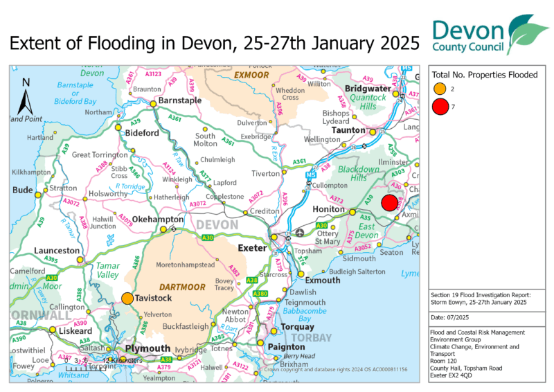
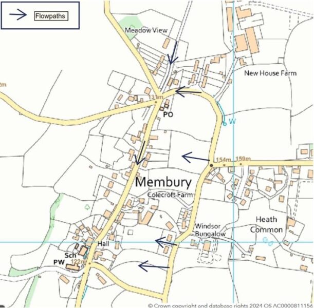
Figure 3.1 shows the geographical extent of flooding across Devon. Table 3.1 lists the individual towns and villages affected on this date together with the reported number of properties flooded in each location. It should be noted that the flooded locations have been reported alphabetically and not in any order of priority.
| Location | Number of properties flooded | Source of flooding |
| East Devon | ||
| Membury | 7 | Ordinary Watercourse/Surface Water/Sewerage |
| West Devon | ||
| Tavistock | 2 | Surface Water/Groundwater/Ordinary Watercourse |
| Total properties flooded: 9 | ||
3.2 Incident response and recovery
Initial community engagement and drop in events:
When a flood event occurs, it is immediately followed by an emergency response and then recovery phase. There are many roles involved in this process, covered by the Emergency services, Environment Agency, and local authorities. Details of this are included in the Multi-Agency Flood Framework. As LLFA, DCC’s Flood & Coastal Risk Management team becomes involved at the recovery phase, through recovery coordination, community engagement and investigation.
Following any flood event, DCC will engage with relevant District Councils, Risk Management Authorities, local Parish and Town Councils and community members to gather information. This information is shared with other agencies to determine the extent of impact.
4. Flood Incident Extent and Impact
4.1 Membury
Membury is a rural village and parish in East Devon with a long record of historic flooding. DCC records show flooding on 13 Dec 2008 with at least 7 properties flooded and on 21 Nov 2012 with a property flooded by surface water. Records also suggest property flooding in July 1968, Dec 1972 and Dec 2000.
Membury Neighbourhood Plan also provides an informal record of flood incidents as occurring on the additional dates of 1 Oct 1976, 20 Dec 1989, 1 Jan 1998, 4 Feb 2002, 1 Feb 2004, 25 Jan 2013.
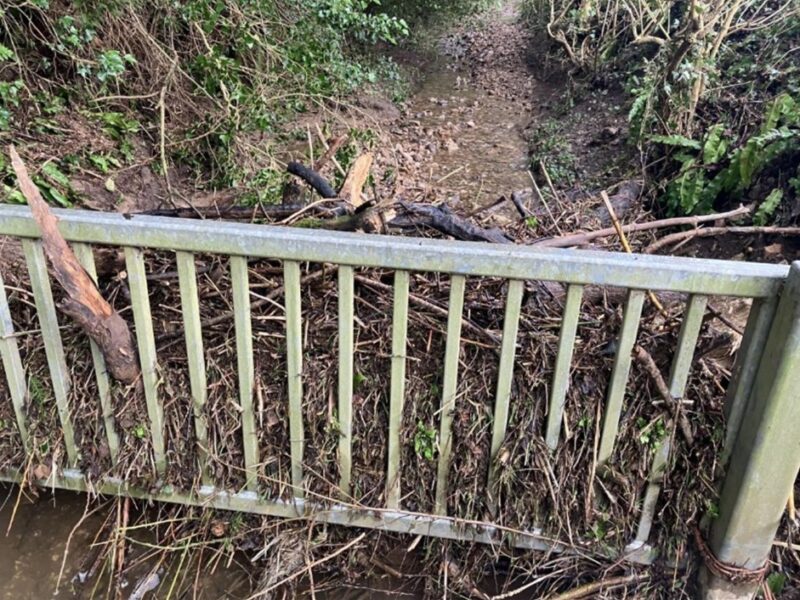
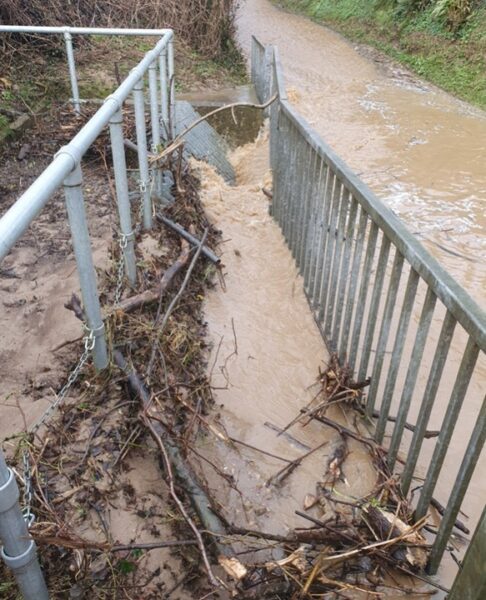
Following previous flooding incidents, a flood alleviation scheme understood to have been delivered by East Devon District Council was introduced on Bond’s Lane in the 1980s. A warning siren system was installed by the Environment Agency in 2012 which is actioned by an active group of local flood wardens. A metal bar gate as an informal debris catcher on Bond’s Lane was added by the community in recent years (see figures 4.1 and 4.2).
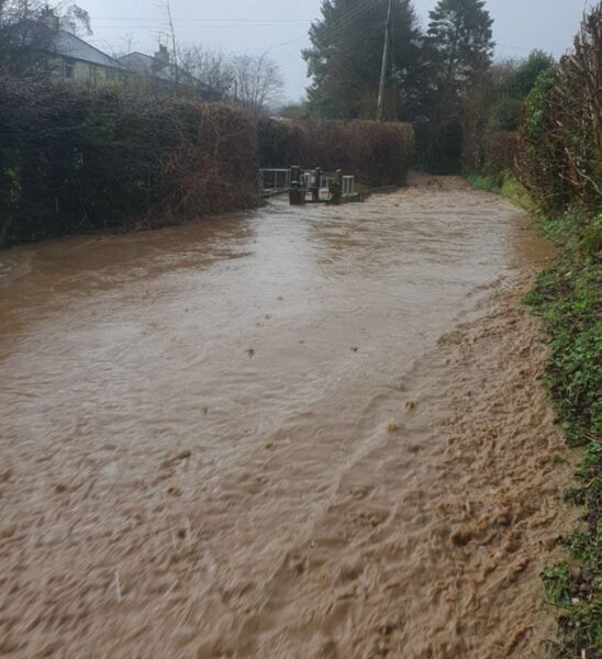
On 26 January 2025, a further incident of flooding occurred with at least seven properties internally flooded and many more experiencing near misses or flooding to gardens and outbuildings. Flood depths varied, with some experiencing minor ingress and one or two properties reported to have flooded up to ‘8 inches’ deep internally.
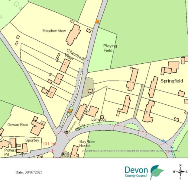
Properties in Membury Village and the downstream hamlet of Rock were impacted by the coalescing of surface water flowpaths and an ordinary watercourse, which combine along the main road through Membury Village.
There were significant surface water flows along the length of the bridleway from Challenger Farm along Bonds Lane. This flow should join with an unmapped ordinary watercourse (which is piped from a property at Springfield into the sump itself) at the sump on Bond’s Lane. The gate debris catcher along the bridleway was effective in capturing large amounts of material but the sump system downstream still experienced some blinding during the event. This resulted sheet flows across the road network, as shown in figure 4.3.
Video and photo footage from the event suggest that the overland flows from Bond’s Lane were very similar in scale to overland surface water and ordinary watercourse flows from the East which combined where the roads join at the cross roads adjacent to Hallendale/Bay Tree House. These flows were unable to join the watercourse, which is understood to have been running at full bore. Flows were then directed into properties and gardens along the main road in Membury.
In addition to the Bond’s Lane flows, there were also surface water flows and a minor watercourses flowing through fields from the east and impacting upon the rear of properties, these were most impactful where easements were blocked and therefore, sheet flows poured across these fields. This was the primary source of flooding to one property and has unfortunately left the home uninhabitable in the months following the event. These flowpaths are mostly picked up on national mapping, however, the condition of the easements suggests that where one blocks, these flows can combine or run uncontrolled over the fields exacerbating the issue.
Despite considerable amounts of pooling of surface water and floodwaters not reaching the watercourse at Membury, a property near Lewsey Lane about 1km downstream also flooded from the watercourse overtopping its banks, and footage shows the flooding of the ponds of the former Trout Farm at Rock which sits in-between Lewsey Lane and Membury Village.
Flood warning
The flood warning on the Membury sump offers only a limited warning time. In this instance it was viewed as ineffective by residents, as much of the sump was bypassed by flows. It is locally reported that a blockage on the screen led to the system filling up within seconds, thus a rapid rise in levels and therefore, the first warning was skipped. Maintenance records from East Devon District Council show that the sump system had been cleared in the weeks prior to the storm. It is therefore, assumed by the community that the screen blocked with material from the bridleway limiting flows into the sump.
Level data from the warning system shows a rise in levels from 9:30am at 0.38m to 0.86m at 11:45am, then a gradual decrease until 1:30pm. Levels at 1:45pm are recorded at 0.81m and then increase rapidly to 2.16m at 2pm. This data aligns with resident’s views that the sump screen was potentially blinded during the event.
There were issues with turning off the siren itself following the flooding due to the flood warden being away, and the second key holder unknown. Residents are putting in place plans to relocate a key to a community building to address this issue in the future.
4.2 Tavistock
One property on Whitchurch Road flooded from surface and ground water entering the property through the floor. The property has flooded multiple times in the last three years. Water flowed off the neighbouring fields and out of a retaining wall on a field adjacent to the property. The garden of the property also became waterlogged but the nearby watercourse reportedly did not flow out of bank during the flooding.
At least one property in Wyatts Lane/Glanville Road reported external flooding in the road and external areas as over ‘1ft deep’ with minor ingress internally into a property, associated with surface water and overtopping of an ordinary watercourse.
5. Recommended Actions
As a result of this investigation report, several recommendations have been made for actions to be considered in specific locations. These are either as a result of initial site or desktop investigations, or the continuation of works or investigations already in progress. DCC as the LLFA will continue to monitor and record all flood incidents that come to our attention and consider this within our action plan and future investment programme. The current action plan can be found on the DCC Flood Risk Management Website at https://www.devon.gov.uk/floodriskmanagement/. Table 5.1 below summarises the recommended actions for this flood incident.
As stated earlier in this document, the purpose of this report is to act as a tool for all of the relevant RMAs to understand and appreciate the extent of flooding in their area and to consider and prioritise those actions relevant to their authority. Due to the extent of flooding, not only from the events covered in this report, the level of recommended actions far exceeds the budgets and resources available to enable them to be delivered immediately. Although we take all flooding issues seriously it should therefore be appreciated that some actions may not be progressed within the timescales expected by some residents or communities. Every effort will be made to progress the actions if and when suitable funding is obtained.
The recommended actions highlighted in this report will be used by the LLFA to monitor progress achieved by the RMAs.
| Action By | Recommended Action |
| General actions recommended for the areas featured in this chapter: | |
| EA / LLFA / Local communities | Where applicable assist with the development of community emergency/flood action plans. Advice and possible funding are available from Devon Community Resilience Forum to increase community resilience to all affected communities. |
| EA / LLFA / DCC PROW / Local communities | To consider options available to support a community led scheme for natural flood management measures to reduce the risk from Bond’s Lane with the long term aim of enabling the Bridleway to be re-opened. |
| LLFA / East Devon District Council / Local Communities | To review the effectiveness and resilience of the community emergency plan and procedures in a flood event. |
| DCC Highways | Review, and where required, carry out maintenance in problem areas to ensure efficient operation of highway drains and culverts. |
| Property Owners / LLFA / EA | Consider flood risk to own properties and to install property level protection where necessary in liaison with appropriate Risk Management Authorities. |
| SWW | Continue maintenance regime and consider works to ensure efficient operation of public combined and surface water sewers. |
6. Next Steps
The next steps following this report will be for DCC as the LLFA to ensure that the recommended action tables in each chapter are presented to the responsible Risk Management Authority. DCC will consider their actions in line with other priorities and monitor delivery through regular reviews, whilst working in partnership with the EA, District Councils, SWW and the local communities affected.
There is an expectation from DCC of itself and its partners that all authorities involved will cooperate and work together to reduce the flood risk in the vulnerable areas identified in this report by completing the recommended actions. As the LLFA, DCC has a responsibility to oversee the delivery of these actions.
Where minor works and quick win schemes have been identified, these will be prioritised and subject to available funding and resources will be carried out as soon as possible by the relevant authority or landowner. Any major works requiring capital investment will be considered through Defra’s Flood Defence Grant in Aid process.
A review of the actions will be carried out by DCC as the LLFA to monitor progress and encourage delivery of recommended actions.