Contents
Managing Land to Reduce Flood Risk
This document considers the problems and impacts of land management on flooding and some of the solutions available
This guidance document focuses on the effect on flood risk from the management of soils, planting of woodlands and managing surface water runoff in upland areas, highlighting methods that can be used to reduce flood risk through good land management. These methods range from being localised in farmland areas to larger catchment area projects.
Geology, soil, climate, aspect, slope and use all affect the way water flows from land. The types of land management will in turn influence the way in which water percolates through the soil, and where this does not happen, the way in which it moves across the land as surface water runoff. Excess runoff can affect homes and businesses by flooding roads and property. It can also carry sediment onto roads and property and pollutants into rivers and groundwater, causing ecological impacts and affecting the quality of water supplies.
Good land management enables water to infiltrate the soil, creating multiple benefits for flood risk and the environment.
The Problems
Impact of soil and field conditions on flood risk
Soil Compaction
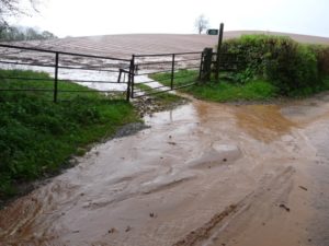
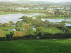
Soil damage caused by compaction and where the soil surface becomes sealed can reduce the vertical movement of water through the soil causing overland flow. This occurs mainly due to working and travelling on the land when the soil is too wet and soft. During heavy and prolonged rainfall this can lead to localised flooding in situations where the soil would normally absorb rainfall. Such surface water flows can represent an unnecessary flood risk at a local level, contribute to other sources of flood water, or can convey sediment into watercourses which in time may reduce the channel capacity and seriously damage the ecology of the watercourse.
Devon is predominantly a rural County. Our relatively wet climate, steep slopes and sensitive soils prone to compaction and erosion can present risks of local flooding problems from enhanced run-off.
Soils conditions in the South West and Devon
The Environment Agency has surveyed soil condition in relation to runoff across the South West Region (Cornwall, Devon, Dorset, Somerset and Wiltshire). This work showed that 10% of soil samples were in good condition, 38% had sufficiently degraded soil structure to produce observable enhanced surface water runoff during winter, with the remaining soils being in moderate condition, producing some runoff. There was an opportunity identified here to work with those areas where there were found to be problems to identify practical solutions [1].
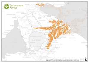
High risk soils in Devon
Sandy and silty soils on the ‘Devon Redlands’ (see Figure 3) are the most at risk of causing enhanced surface water runoff and associated soil erosion. The landscapes at risk include East Devon and parts of mid-Devon that overlie the permo-triassic sandstone, breccias and mudstone.

Most of the soils in these landscapes readily absorb winter rainfall even on steep slopes but are at risk of becoming sealed by processes that cause the soil to cap and slump on the soil surface, and by soil compaction. This in turn generates overland flow of water which causes soil erosion and loss of soil on these naturally unstable soils. In some cases soil erosion can cause large gulleys at the base of steep slopes. The enhanced runoff and soil loss can cause localised ‘muddy floods’ blocking road drains and causing muddy water to flow into adjacent property.
Soil erosion can be a common occurrence in wet years on the sandy soils around Exeter and along the lower River Otter valley. It also occurs more locally on the stony steep soils near Teignmouth and Torbay and along the Redlands that extends towards Crediton. Some of the wetter soils that overlie the red clay mudstones in East Devon (that have a high silt content with unstable topsoils) also have a high risk of runoff and erosion. These soils are particularly sensitive to compaction where harvesting of crops occurs late in the year in wet conditions.
High Risk Crops
The main crops that have a high risk of producing runoff and soil erosion in these landscapes are the arable crops such as maize, vegetables, winter cereals and winter fodder crops. The risk of runoff occurs particularly where the soils are left bare and compacted over the winter.
These soils can be managed successfully and profitably to reduce the risk of runoff by skilful soil husbandry when they are in arable cultivation. This involves timely working to prevent soil compaction when travelling on the soil, and by ensuring adequate crop cover over the winter to protect the soil from the battering action of the rain. Where soils become damaged by compaction, they need careful management to break up dense layers by subsoiling and deep soil loosening.
However, it should be noted that subsoiling can damage archaeological sites. Seek advice from the Archaeological Officer of your Local Authority if you are unsure about the status of an historical site.
[1] Palmer, R. C. and Smith, R. P. (2013), Soil structural degradation in SW England and its impact on surface-water runoff generation. Soil Use and Management. doi: 10.1111/sum.12068.
The Solution
Good soil management
Excessive surface-water runoff can be prevented by good soil husbandry and by matching the choice of crops to suitable ground. It is generally not in the interest of farmers to have soil compaction. The choice and timing of cultivation practices can be tailored to avoid unnecessary soil compaction and where this is caused, the soil can be loosened. However good soil husbandry is not always easy when the weather is bad and a crop needs to be harvested.
Where there are persistent problems with flooding or sediment run-off that are directly attributable to particular land management practices, such as mud and sediment on roads and watercourses causing pollution, there are regulatory measures open to the Environment Agency and Local Authorities.
Farmers have to adopt good soil management as part of their ‘cross-compliance’ requirements to prevent soil runoff and erosion when receiving farm subsidy payments administered by the Rural Payments Agency.
Government Cross Compliance soil protection standards for 2015 set out standards for using minimum soil cover to reduce soil erosion and methods to reduce this, which will in turn reduce surface runoff.
The farming community is working closely with Defra and the Environment Agency to ensure that best practice becomes standard practice. This is already in place with schemes such as Countryside Stewardship water capital grants: catchment sensitive farming. This new environmental land management scheme will be replacing the previous agri-environment and grant schemes, Environmental Stewardship, English Woodland Grant Scheme and capital grants from the Catchment Sensitive Farming programme. In addition to this the agricultural sector, along with government and environmental organisations, is promoting the Campaign for the Farmed Environment as a way of communicating with farmers about the issues and opportunities provided by resource management and good soil husbandry.
You can check if your farm is in a Catchment Sensitive Farming priority catchment area on Natural England’s website. If it is, contact your Catchment Sensitive Farming Officer for advice on the support available to help you tackle diffuse water pollution from agriculture.
Countryside Stewardship water capital grants: catchment sensitive farming will focus on helping farmers and land managers to achieve benefits for biodiversity, water quality and flood management together. It is a joint initiative between the Environment Agency and Natural England, funded by Defra and the Rural Development Programme for England. It provides advice on practical solutions, support and funding solutions in priority catchments within England to enable farmers and land managers to take voluntary action to reduce diffuse water pollution.
Planting Woodland
Benefits to reduce surface water runoff and flood risk
The targeted planting of trees on arable land or pasture can reduce surface water runoff and the risk of flooding. In addition to this, shelter belts of trees can have a positive impact on pasture growth by increasing water infiltration.
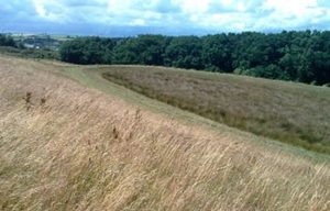
Planting in areas known to be vulnerable to surface runoff will provide the greatest benefit, reducing the amount of surface runoff and sediment reaching watercourses. Planting in known runoff and sediment pathways interrupts flow and increases soil infiltration, and planting along contours will reduce erosion. Planting woodland on steep land at high risk to runoff and erosion can provide a long term cost-efficient solution to localised flooding.
On floodplains, woods and trees can mitigate the effects of large floods, absorbing and delaying the release of flood flows, reducing downstream flood risk. Wet woodlands are those that are frequently or seasonably wet through the flooding of rivers or from other geological features such as springs or clay soils that will hold water. These have benefits to wildlife and water quality in addition to flood risk through increased flood storage. Good areas to encourage wet woodlands to reduce flood risk are sites with naturally occurring springs or on natural river floodplains and areas of low lying land which flood regularly. Areas to avoid would be where river water might back up behind the woodland causing problems for neighbours or increasing flooding on roads.
Current research into the role of floodplain woodlands in reducing flooding is currently a major element of the Forestry Commission’s forest hydrology programme.
Along watercourses tree roots can bind the soil and help to stabilise banks, reducing erosion and sedimentation. It should however be noted that in England and Wales. Therefore it is important to consult the Environment Agency in these areas, as trees in the wrong place could increase flood risk.
Make sure new planting also respects and enhances the distinctive character of the area and provides wildlife benefits – by using native species common to the local area and following management guidelines in landscape character assessments applicable to your area.
It should be noted that planting woodland can potentially damage archaeological sites. Seek advice from the Archaeological Officer of your Local Authority if you are unsure about the status of an historical site.
Advice
The English Woodland Grant Scheme has been replaced with the new environmental land management scheme Countryside Stewardship.
For advice on planting woodlands for flood risk management measures, in addition to other wider environmental benefits, The Woodland Trust can offer help and advice designing your wood, considering species choice and after care. The Woodland Trust provides help and support for communities and small projects wanting to plant on public land.
Devon’s landscape character assessments provides more information.
Wider catchment land management
Reducing flood risk through good land management is often looked at over the wider river catchment areas. Although land management at a local scale has been shown to have a significant impact on surface water runoff, there is still uncertainty for the larger catchment due to the complexity of different factors involved across the catchment and downstream. Any localised improvements may not necessarily have a big effect much further down the catchment depending on scale.
As highlighted by the Upland Hydrology Group (Reference), upland land management and local land management should be looked at in conjunction with other methods, as part of an integrated approach to flood risk management which is complemented by other land based opportunities downstream; such as hard engineering solutions and decisions which steer development away from vulnerable sites.
Northern Devon Nature Improvement Area
The Northern Devon Nature Improvement Area (NIA) [2] is one of 12 flagship landscape scale initiatives, supported by Defra. It is led by the Devon Wildlife Trust on behalf of the North Devon Biosphere Reserve Partnership. The Northern Devon NIA covers the River Torridge catchment and is a major local project for managing the local landscape and environment to encourage nature and wildlife and in the process to manage flood risk by incorporating techniques to reduce surface water runoff.
The river Torridge in North Devon covers a predominantly rural area, characterised by steep wooded valleys and a mixture of pastoral and arable farming.
Helping farmers with land and soil management
Farmers face considerable pressures as small businesses, especially with ever more unpredictable weather patterns and rising costs, but they can make a major contribution to the river basin district in terms of the economy, food security, landscape, water quality and water storage, biodiversity and recreation.
The NIA helps farmers apply for funding through schemes such as Catchment Sensitive Farming, which helps farmers and land managers to take voluntary action to diffuse water pollution from agriculture to protect water bodies and the environment.
The NIA provides advice and assistance on water resource through the use of agri-environment schemes, applying for grants and visits to help with improving drainage and identifying areas at risk of erosion and maintaining soil conditions. The NIA also offer free loans of soil aerators to reduce and relieve soil compaction, helping water to infiltrate into the soil and reduce surface water runoff.
Encouraging woodlands
The NIA also encourage the creation of new native woodland on appropriate sites. The creation of new native woodlands increases the current cover of this important habitat and also provides opportunities for landowners to become more self sufficient in providing for their energy needs. It can also help to reduce the effects of nutrient run off and flooding in catchment sensitive areas.
Managing uplands
Land management in the uplands can have an impact on the amount and timing of surface water runoff, with implications both for water supply and for flood risk management. The uplands are critical in this respect because they supply a large percentage of our drinking water, and often contribute disproportionately to flood events downstream.
Restoring Culm Grasslands
Drawing on techniques pioneered by the Devon Wildlife Trust’s Working Wetlands programme, the NIA is also working to restore and recreate Culm grassland, a habitat of international conservation importance. During the past century this habitat has experienced significant damage and degradation, primarily due to agricultural intensification and land drainage. Restoration and re-creation work serves not only to restore, enhance and reconnect Culm grassland, but also to greatly increase the capacity of the landscape to hold and store water, reducing the risk of downstream flooding and protecting against the impacts of drought. Independent research by the University of Exeter shows that Culm grasslands can store up to five times as much water as intensively managed grasslands. In addition modelling scenarios suggest that compared to Culm grasslands, 11 times more water rapidly leaves intensively managed grasslands during storms, increasing the risk of flooding downstream. This approach is also part of South West Water’s Upstream Thinking Initiative, where Devon Wildlife Trust’s Working Wetlands team are a key deliver partner.
Upstream Thinking Initiative
The South West Water initiative, Upstream Thinking [3] aims to improve water quality and manage the quantity of water at source long before it reaches water treatment works. It aims to restore raw water sources and keep them free from pollutants, reducing the chemicals, cost and energy needed to produce tap water on which we all depend. This also brings multiple benefits to the environment, such as enhancing biodiversity and reducing flood risk.
There are several projects within Devon under this initiative which includes the Exmoor Mires project. The focus of the Exmoor Mires Project is to block drainage ditches using sustainable methods, local materials and local contractors in order to ‘re-wet’ the bog, enabling it to retain water and carbon. During periods of heavy rainfall, re-wetted peat bogs slow down the run-off of water from land before steadily releasing it. This increased water storage has the effect of reducing the fluctuation of river flows, making flooding less likely, reducing soil erosion and the amount of silt entering rivers.
[2] Northern Devon Nature Improvement Area www.northerndevonnia.org
[3] Upstream Thinking, A South West Water Initiative www.upstreamthinking.org
Soft engineering options and sustainable drainage
Soft Engineering is using methods such as creating earth bunds to deflect surface water or creating small ponds, altering the land to manage the surface water flows in order to reduce the risk of localised flooding. Sustainable Drainage Systems (SuDS) are used in new developments to manage surface water using systems that mimic natural drainage processes, such as ponds and infiltration, rather than hard engineering or positive drainage such as pipes. There are many different SuDS methods that can be used to manage surface water flows whilst treating the water for any pollution, by catching sediment and heavy metals and also creating green open spaces with added amenity value. Devon County Council SuDS guidance sets out local standards for new developments and can be found on the Council’s website.
The use of sustainable drainage is also relevant to home owners when considering alterations to gardens and driveways. By paving over a grass surface that could previously absorb rainfall, excess surface water could be created which can flow on to surrounding land and impact on the local drainage. This ‘urban creep’ across towns and cities could impact on urban catchments, increasing surface water flows. Putting thought into this kind of development and using permeable surfaces such as permeable paving or gravel can increase infiltration and reduce the amount of surface runoff. Using French drains, private soakaways and considering where surface water will flow and channelling/redirecting it where appropriate is also beneficial and should be considered as part of any alterations. Planning permission may be required for some alterations with impermeable surfaces so it is sensible to approach your Local Planning Authority for advice before considering any works.
However, it should be noted that creating ponds can damage archaeological sites. Seek advice from the Archaeological Officer of your Local Authority if you are unsure about the status of an historical site.
Quick guide
Methods to reduce flood risk and soil erosion
There is not just one method that can be used to influence whole catchments and to tackle the increasing risk from intense rainfall and surface water runoff. All of these methods must be integral to a larger system across the rural and urban landscapes, alongside hard engineering solutions and the regulation and improvement of urban drainage systems and the encouragement of sustainable methods, whilst enhancing the natural environment and its wildlife and ecology…
Reducing soil compaction by…
Avoid poaching and unnecessary travelling on soil
Poaching is the damage caused to land from livestock treading and compacting the soil when it is too wet. Avoiding this where possible will promote good soil structure that will enable water to infiltrate and reduce surface runoff.
Polytunnels and vehicle traffic on headlands and tracks are also a common cause of compaction and runoff which can lead to soil erosion.
Subsoiling and aeration
Carrying out subsoiling will break up and loosen dense and compacted soil. Doing this when the soil is dry will ensure that the soil breaks up easily. Soils should be examined by digging to look for compaction. Do not leave compacted stubbles over winter where these are prone to runoff and soil erosion.
However, it should be noted that deep subsoiling could damage archaeological sites. Seek advice from the Archaeological Officer of your Local Authority if you are unsure about the status of an historical site.
Manage overland flow by…
Ditch and watercourse clearance and maintenance
Maintaining ditches on private land to keep clear of blockages and restrictions will reduce the risk of flooding upstream and enable land to drain more easily, avoiding large volumes of overland surface water flow.
Creating banks and diversion ditches within fields can intercept and slow down surface water runoff.
Planting woodlands, trees and vegetation
Increasing woodland cover within the catchment can slow down overland flow in addition to allowing surface water to infiltrate into the soil where root structures create a porous soil structure, in turn reducing surface runoff volumes.
The planting of trees or vegetation in appropriate places, such as shelterbelts and hedgerows along contours and across known surface water flow paths can help to slow down overland flow and reduce runoff by acting as a barrier and also increase infiltration into the soil.
Restoring degraded moorland with vegetation, blocking of old drainage grips and managing stock to prevent overgrazing will also help to slow down runoff in upland areas.
Creating ponds and wetlands
By creating ponds and wetlands, storage capacity can be made for flood waters and help to slow down flood flows. Temporary ponds will create flood storage areas and help to reduce the impact downstream by slowing down and reducing flows. One method of creating these is through ‘leaky dams’ made up of woodland debris in wetland areas to create temporary ponds that will fill up in times of high flow and empty gradually at a controlled rate. These need to be carefully designed and constructed to ensure they are robust and do not create a risk from sudden deluge or release of water or cause blockage from debris passed downstream.
Time appropriate activities such as…
Planting crops early
When possible planting crops early when the soil is dry (following subsoiling if appropriate) can ensure good crop cover over the winter to protect the soil from the battering action of the rain particularly on light soils at risk of erosion.
Working during dry conditions where possible
Establishing crops early in the autumn during dry conditions will ensure good soil structure and good crop cover over the winter, reducing soil erosion and surface runoff.
Other considerations such as…
Choosing appropriate fields
Some crops and practice have an inherent high risk of causing runoff such as maize, vegetables and out-wintering of stock. Where possible, avoid planting high risk crops on steep ground in areas prone to flooding.
Soil erosion can occur in crops planted in rows and beds where runoff can be channelled
down a slope. Planting headland rows and beds across the base of a slope can intercept any surface water runoff. Wherever possible, relatively flat fields should be used for growing row crops.
Position of access gates
By placing access gates onto roads on higher land in a field where possible, surface runoff will be less likely to find a pathway out and onto the public highway, which could then lead to surface water flooding downstream.
Land management and climate change
Surface water runoff from soil damage could be made worse with more extreme weather patterns and the potential for more intense rainfall events where large amounts of water falls in a short period. There will be even more need for co-ordinated management, working with farmers and land managers to take active steps to prevent damage to their soils contributing to wider flooding problems, meeting the challenges of a highly unpredictable future
Getting consent
It is important to check that any proposed work as part of this scheme (countryside stewardship) won’t damage environmental features such as biodiversity, landscape or the historic environment. For example, bank side vegetation or traditional farm buildings. In addition to this, Environment Agency consent is required if carrying out work affecting slurry or silage storage systems. Various consents are also required when working in or near to a watercourse: Main Rivers will require Flood Defence Consent from the Environment Agency. All other rivers, streams and ditches are known as ordinary watercourses and will require Land Drainage Consent from Devon County Council. Planning permission may also be required for some works. Your local Planning Authority will be able to advise on when this is necessary.
Grants and funding available
Catchment Sensitive farming :
For more information on Catchment Sensitive Farming and Capital Grants Scheme
Agri-Environment Schemes:
For more information on Agri-Environment Schemes
Woodland Trust:
Visit Woodland Trust for information and to see if you are eligible to apply for financial support to plant trees on your land.
Forestry Grants:
Visit the Forestry Commission for information on various woodland grant schemes available.
Northern Devon Nature Improvement Area:
Visit Northern Devon Nature Improvement Area/ for information on a range of grants and advice available.
Countryside Stewardship:
Further information on Countryside Stewardship
Useful contacts and further information
For help and advice on any local land management issues and how you can improve the management of your land to reduce flood risk, there are several bodies, charities and projects that can offer assistance or possible funding opportunities:
Environment Agency:
Visit gov.uk/environment-agency or call 03708 506 506
Think Soils Manual:
Visit ahdb.org.uk/thinksoils
Devon County Council Flood Risk Management:
Visit devon.gov.uk/floodriskmanagement or call 0345 155 1015
Devon County Council Historic Environment:
Visit devon.gov.uk/historicenvironment or call 01392 382246
National Farmers Union:
Visit nfuonline.com or call 024 7685 8500
Woodland Trust:
Visit woodlandtrust.org.uk or call 01476 581135
Forestry England:
Visit forestryengland.uk or call 01392 834242
Department of Food and Rural Affairs (Defra):
Visit https://www.gov.uk/government/organisations/department-for-environment-food-rural-affairs
Upland Hydrology Group:
Visit moorsforthefuture.org.uk/upland-hydrology-group
Northern Devon Nature Improvement Area:
Visit northerndevonnia.org or call 01409 221823
Devon Wildlife Trust & Working Wetlands:
Visit devonwildlifetrust.org or call 01392 279244
Natural England:
Visit https://www.gov.uk/environment/rural-development-land-management or call 0845 600 3078
Government Cross Compliance soil protection standards for 2015:
Visit https://www.gov.uk/government/publications/cross-compliance-guidance-for-2015