Section 19 Flood Investigation Report
This flood investigation report has been produced by Devon County Council as a Lead Local Flood Authority under Section 19 of the Flood and Water Management Act 2010.
| Version | Undertaken by | Reviewed by | Approved by | Date |
| Draft 1 | Jago Burris | Jessica Bishop | March 2026 | |
| Final | Jago Burris | Jessica Bishop | John Galt | March 2026 |
This report covers the flooding incident between 27th and 29th August 2025 and has identified all flooded properties within the County that we have been able to determine or brought to our attention. Based on the criteria set out in our Local Strategy this single report covers the requirement for one individual Section 19 Flood Investigation Reports together with details of other flooded locations during this incident period.
Further details on how Devon County Council manages local flood risk can be viewed here: https://www.devon.gov.uk/floodriskmanagement/document/devon-local-flood-risk-management-strategy-2021-2027/
1. Introduction
The Flood Risk Regulations 2009 and the Flood and Water Management Act 2010 (the Act) have established unitary and upper tier local authorities as the Lead Local Flood Authority (LLFA) for their area. This has placed a number of responsibilities on the LLFA in relation to flood risk management and in particular Section 19 of the Act which states:
| Flood and Water Management Act 2010: Section 19 – Local Authorities: investigations. On becoming aware of a flood in its area, a lead local flood authority must, to the extent that it considers it necessary or appropriate, investigate – which risk management authorities have relevant flood risk management functions, and whether each of those risk management authorities has exercised, or is proposing to exercise, those functions in response to the flood. Where an authority carries out an investigation under subsection (1) it must – publish the results of its investigation, and notify any relevant risk management authorities. Flood and Water Management Act (2010), S.19, c.29, London: HMSO |
A ‘Risk Management Authority’ (RMA) means:
(a) the Environment Agency (EA),
(b) a lead local flood authority,
(c) a district council for an area for which there is no unitary authority,
(d) an internal drainage board,
(e) a water company, and
(f) a highway authority.
The responsibilities of Risk Management Authorities are detailed in Appendix A.
When considering if it is necessary or appropriate to investigate a flood event Devon County Council (DCC) will review the severity of the incident, the number of properties affected and the frequency of such an occurrence. Devon’s Local Flood Risk Management Strategy clearly sets out the criteria to be used when considering a Flood Investigation Report.
Although not all of the locations in this report meet the significance threshold of 5 or more properties flooded, to ensure that the full extent of the flooding is appreciated and recorded it has been decided to include all locations brought to our attention which experienced any internal property flooding, and also other areas of particular concern.
In partnership with the other RMAs in Devon this report has been produced to comply with legislation and to determine the main causes of the flooding. It should be noted that in order to progress with their flood risk management function DCC has opted to develop this report further by considering the various actions that should be considered by the relevant RMA. DCC as the LLFA will continue to monitor the list of actions with all of the RMAs and will assist in the delivery where practical to do so. More information on RMA’s responsibilities can be found in Appendix A at the end of this report.
It should be noted that this report is only based on the information brought to the attention of DCC through its professional partners, the media and the public and where further investigation by the authorities have identified additional flooded properties. Therefore, it cannot be guaranteed to contain an exact or exhaustive list of individual properties or affected communities.
2. Incident Summary
2.1 Incident Summary
On the evening of the 28th August 2025 through into the early hours of the morning on 29th August, intense rainfall caused flooding to properties across multiple communities in the South Hams. Rainfall data from gauges in the South Hams indicate that there was intense rainfall overnight with the gauge at Hanger Down, Ivybridge recording an intensity of over 50mm per hour around midnight. There was significant disruption to the highway network in the South Hams including fallen trees, surface water flooding and a landslip across the A379.
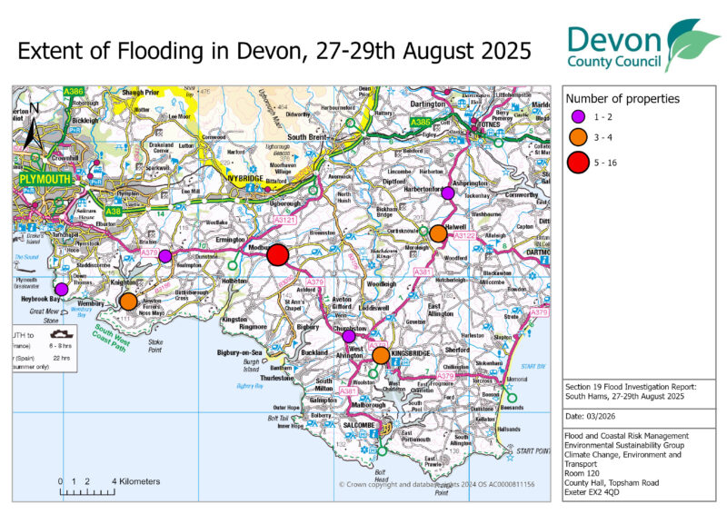
Internal property flooding was reported in nine communities across the South Hams, most notably Modbury with 15 properties flooded. In total, 32 properties (16 residential and 16 commercial) have been recorded as experiencing internal property flooding during this event. The affected properties were flooding due to either surface water or out of bank flows from Ordinary Watercourses. No Main River or coastal flooding was reported during this event.
Table 2.1 lists the towns and villages affected on this date together with the reported number of properties flooded in each location. These have been identified on Figure 2.1 above to show the geographical extent of flooding across Devon. It should be noted that the flooded locations have been reported alphabetically and not in any order of priority.
| Location | Number of properties flooded | Source of flooding |
| Churchstow | 1 | Surface Water |
| Halwell | 3 | Surface Water |
| Harbertonford | 2 | Surface Water/Sewage |
| Heybrook Bay | 2 | Surface Water |
| Kingsbridge | 4 | Surface Water/Main River/Sewage |
| Modbury | 15 | Surface Water |
| Newton Ferrers | 3 | Surface Water |
| Yealmpton | 1 | Surface Water |
| California Cross | 1 | Surface Water |
| Total properties flooded: 32 |
Rainfall data
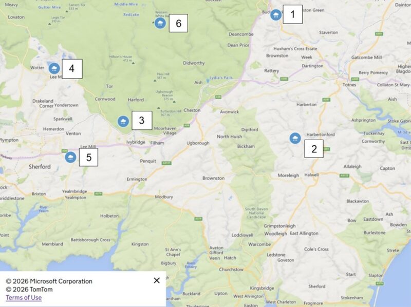
August 2025 had above average temperatures and sunshine with rainfall below average at 62% of the long term average (August 2025 weather stats: A regional breakdown – Met Office). In the hours and days prior to the flooding on the night of 28th August, Devon had experienced some rainfall with figures produced in Table 2.2.
| Label | Location | 26 Aug 2025 | 27 Aug 2025 | 28 Aug (up to 23:30hrs) |
| 1 | Austins Bridge | 0.7 | 12.4 | 9 |
| 2 | Harbertonford Slipperstone | 0.9 | 12.9 | 11 |
| 3 | Ivybridge Hanger Down | 1.9 | 9 | 15.9 |
| 4 | Lee Moor | 1.1 | 4.6 | 27.4 |
| 5 | Plympton | 1.1 | 6 | 13.5 |
| 6 | Whitebarrow | 5.5 | 15.4 | 26.8 |
| Label | Location | 23:30-23:45 (15 min) | 23:30-00:00 (30 min) | 23:30-00:15 (45min) | 23:30-00:30 (1hr) |
| 1 | Austins Bridge | 2.2 | 12.7 | 17.3 | 18.7 |
| 2 | Harbertonford Slipperstone | 0.4 | 5.8 | 19.3 | 32.2 |
| 3 | Ivybridge Hanger Down | 12.7 | 29.1 | 32.4 | 32.8 |
| 4 | Lee Moor | 12.1 | 16.5 | 17.1 | 17.1 |
| 5 | Plympton | 11.5 | 34.2 | 37.8 | 38.3 |
| 6 | Whitebarrow | 12.1 | 15.3 | 16.6 | 16.9 |
Rainfall data from Environment Agency gauges show that there was an intense period of rainfall between 23:30 and 00:15 on the night of 28th August 2025 into the morning of 29th August 2025. This band of rainfall appears to have also caused significant flooding from 23:00 onwards, as it moved eastward into Devon in the neighbouring council area of Plymouth, which will be producing its own Section 19 flood investigation for the Plymouth area.
Cumulative rainfall data shows that there was intense rainfall between 23:30 and 24:00 with an intensity of 58.2mm per hour at Ivybridge Hanger Down gauge north of the towns of Ivybridge and Modbury, and also at the Plympton gauge with an intensity of 68.4mm per hour which is northwest of Modbury and north of Yealmpton.
2.2 Impacts on the highway network
During the event on the 28th and 29th August significant surface water flooding affected the highway network across Devon. Highway drainage systems in several areas, particularly in the South Hams, struggled to cope with the drastically increased flows, sometimes causing them to overflow onto the highway. Typically, these highway drainage and sewer systems are not designed to cope with such intense rainfall events. As part of the investigation, it will be recommended that Devon County Council Highways review the highway gullies and consider whether any maintenance issues require attention.
Notable areas of the highway affected:
- Major Flooding closures/ roads impassable:
- A381 near Halwell
- B3196 near California Cross
- Roads reported blocked by trees:
- A381 near Bickleigh
- B3212 near Dousland
- Roads impacted by landslides:
- A379 near Modbury
3. Flood Incident Extent and Impact
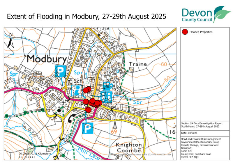
3.1 Modbury
Modbury is a town situated primarily within two main steep sided valleys with a catchment of approximately 1.3km2. There are two culverted watercourses that run north-south through the town, with one culverted at the Exeter Inn pub on Church Street and the other at the top of Burns Lane. The town has a mostly combined sewer network with the majoiry of surface water reliant on entering into South West Water’s combined systems on Brownston Road.
Historic Flooding
1930: Broad St flooded
1968: Broad St flooded
1979: Ayleston Brook flooded
12 Nov 1982: 5 shops and road flooded
10 Jan 1986: 5 shops and road flooded
1 Nov 1992: Properties affected, number unknown.
8 Dec 2007: Property flooded
12 & 17 Nov & 4 Dec 2010: Ordinary watercourse at the Exeter Inn overtopped
Nov 2011: Ordinary watercourse at the Exeter Inn overtopped
6-7 July 2012: Heavy rainfall on saturated ground. Flooding up to a depth of 0.9m. 28 properties affected
Aug 2012: Brownston St flooding, Properties affected.
Nov 2012: Ordinary watercourse at Exeter Inn overtopped. Brownston St flooded.
21-22 Dec 2012: Brownston St and Church St flooded
Flood Extent and Impact
Devon County Council delivered a Flood Alleviation Scheme in Modbury in 2019 which consists predominantly of two bunds upstream of the town, restricting the flow of the watercourses into the town and storing flood water during high flow events. These two bunds operated during this event and the flooding to Modbury was not as a result of flooding from these watercourses.
15 properties within Modbury Village reported internal flooding, with 11 commercial and four residential. The majority of the flooding was caused by surface water flowing down Brownston Street and Galpin Street into the town centre. This caused commercial properties in the town centre on Broad Street and Church Street to experience flooding. Surface water flows overwhelmed or bypassed DCC’s highway drainage in the town including on Church Street and Poundwell Street.
Most of the affected properties are on the south side of the A379 though Modbury with a smaller number of properties on the north side of the road affected. Many of the affected properties are the same as those flooded during the Summer 2012 floods but this time through a different flooding mechanism of surface water flowing down the steep highways.

Some of the affected properties had Property Flood Resilience measures installed on their buildings including flood gates and flood doors. However, during reconnaissance, multiple property owners reported that they did not have their PFR measures deployed when the flooding occurred as they did not receive a warning that there would be flooding that night. The lack of warning that residents received is unfortunately typical of the localised intense flash flooding that occurred, and is a feature of the steep flashy catchments that are common in the South Hams and across Devon.
Residents reported that there was a large amount of material brought with the flood water including mud, stones, and grit that appears to have come from the highway surface.
The flood water also flowed away from the town centre along Poundwell Street where residential properties were flooded.
Multiple businesses have had to temporarily close or relocate as a result of the flooding and many reported losses of stock and revenue due to the flooding. Evidence of damage including ripped up carpets, wrack marks on walls, and mud and water damage was clear throughout many of the affected businesses.
Internal flood depths vary between properties with some reporting up to 1ft of flood water inside where the floor level was lower than the street and others having an inch of water across the inside of their building.
Some of the information for this section (3.1) has been reproduced from Jacobs/DCC’s Devon Modbury Catchment Study V15, March 2013 which is available to view on DCC’s website at: https://www.devon.gov.uk/floodriskmanagement/flood-investigations-reports-and-studies/
3.2 Kingsbridge
Kingsbridge is a town situated on the south coast of Devon and has a significant history of flooding. There are five watercourses which discharge into the estuary at Kingsbridge with an estimated combined catchment of 1,640 hectares. Kingsbridge is affected by flooding from surface water, Main Rivers, Ordinary Watercourse, sewers, and the sea. An Integrated Urban Drainage Management (IUDM) study has been undertaken for Kingsbridge. This report sets out a detailed analysis of the flood risk in the catchment and is available for download on our website here: https://www.devon.gov.uk/floodriskmanagement/flood-investigations-reports-and-studies/
Historic Flooding
The IUDM report has a record of historic flooding up to February 2014.
Kingsbridge has been affected frequently by sewer and surface water flooding, often exacerbated by tidal locking. Notable events since 2014 include:
3rd September 2016 widespread flooding affected Kingsbridge.
27th July 2021 multiple properties were flooded internally.
20th October 2021 two commercial properties flooded internally
4th June 2022 sixteen properties flooded internally including nine residential and seven commercial.
Multiple events throughout February 2024 led to sewer flooding and internal property flooding.
26th November 2024 sewer flooding affected Kingsbridge
Flood extent and impact
On the evening of the 28th August into the morning of the 29th August intense rainfall led to surface water flooding in Kingsbridge. The flooding did not coincide with a particularly high tide.
Surface water flooding affected commercial properties on Mill Street, Bridge Street, Church Street, and Duke Street, and a residential property on Duncombe Street. The commercial properties affected around the town centre reported that surface water flooded the streets and overwhelmed the highway drainage network, causing flood water to enter their properties predominantly through doorways.
Business owners reported that the flood water had sewage in it and left behind debris with a bad smell, indicating that the flooding was in part caused by South West Water’s combined systems being overwhelmed and discharging sewage into the flood water.
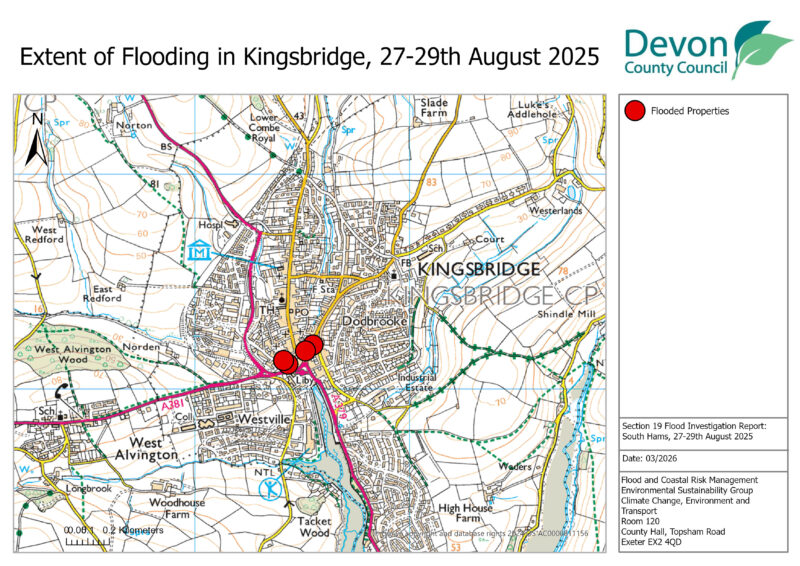
The residential property affected on Duncombe Street reported flooding from surface water.
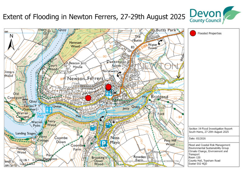
3.3 Newton Ferrers
Newton Ferrers is a village on the south coast of Devon, east of the River Yealm and north of the Newton Creek. A small Ordinary Watercourse run from north to south through the village and discharges into the Newton Creek. There is some flood history associated with this watercourse and DCC has investigated a scheme here but found that Property Flood Resilience measures would be the only feasible option for the affected properties.
Historic Flooding
Newton Ferrers has been affected by multiple flooding events in recent years, predominantly affecting individual properties with surface water flooding.
3rd October 2013 one residential property flooded from surface water.
5th February 2014 two residential property flooded from the sea due to a high tide and wave action.
12th and 26th December 2017 one residential property flooded from surface water.
27th August 2020 one residential property flooded from surface water.
Flood extent and impact
During the night of the 28th August into the early hours of the 29th intense rainfall around Newton Ferrers led to surface water flooding to two properties and came close to flooding a further three others. The flooding was caused by surface water flowing from the fields to the north of the village and through a small ordinary watercourse that flows from north to south through the village.
All the properties that suffered internal property flooding are on Court Road. One of the properties is towards the western end and flooded due to surface water coming from north to south down a track on the north side of Court Road, crossing Court Road and then entering the property through the front door of the property on the south side of Court Road.
The other property that flooded internally was towards the eastern end of Court Road. Surface water flowed from the fields to the north of the village down a track next to The Fairway and onto Court Road. From here surface water flowed into a courtyard and flooded one of the properties surrounding the courtyard.
3.4 Halwell
Three properties flooded internally in Halwell including one residential property, one business and a community building. The properties were flooded due to surface water flows and large volumes of mud and debris running from fields upstream.
3.5 Churchstow
One property in Churchstow flooded internally due to surface water. The flooding was associated with large volumes of muddy runoff from a agricultural field.
3.6 Harbertonford
Two properties were flooded internally from a combined effect of surface water runoff from the highway and sewerage flooding.
3.7 Heybook Bay
Two properties in Heybrook Bay flooded internally due to surface water which entered the properties through their front doors from the highway and over drop kerbs and into their front gardens.
3.8 California Cross
One commercial property flooded internally in California Cross due to surface water. Surface water. Muddy surface water from adjacent field and the highway flooded the car park of the property and entered the kitchen. Residents reports that highway drainage was either blocked or was overwhelmed by the volume of the surface water.
4. Recommended Actions
As a result of this investigation report, several recommendations have been made for actions to be considered in specific locations. These are either as a result of initial site or desktop investigations, or the continuation of works or investigations already in progress. DCC as the LLFA will continue to monitor and record all flood incidents that come to our attention and consider this within our action plan and future investment programme. The current action plan can be found on the DCC Flood Risk Management Website at https://www.devon.gov.uk/floodriskmanagement/. Table 5.1 below summarises the recommended actions for this flood incident.
Each affected area or group of smaller areas investigated within this report will have a number of recommended actions to be taken forward by the relevant RMAs or in some cases, by the landowner or local community action group. There are various levels of action that can be taken depending on the severity of the situation and the practical solutions available to reduce the risk of further flooding. The recommended actions will generally fall into one of the following categories:
Delivery of Quick win schemes: a solution that can be implemented quickly by the Risk Management Authorities or Local Authority at relatively low cost; some of these have already been completed as this report has been progressed.
Further investigation/research: Further investigations such as catchment studies and hydrological/hydraulic assessments to understand the flow rates and directional paths and evaluate the extent of flooding. These would provide evidence for future capital investment.
Development of future schemes: Where immediate action is not financially viable or a solution not readily available then a larger scale flood alleviation scheme may be required. In such cases national funding would need to be secured together with additional contributions from others, such as local levy, local authorities and other third parties.
Landowner action: Members of the public who own land adjacent to watercourses have riparian responsibilities and therefore have a duty to maintain their section of watercourse to ensure there is no impediment of flow. Other works to protect their property may also need to be funded by themselves to ensure delivery within their timescales.
Community action: In some cases, it may be prudent for community groups to join forces and deliver and maintain their own local schemes. This may generate further contributions from local levy or the LLFA.
This investigation report will provide a starting point, with suggested actions being further refined in the light of further studies and where possible, through further dialog with the affected communities.
| Recommended Actions: The purpose of this report is to act as a tool for all of the relevant RMAs to understand and appreciate the extent of flooding in their area and to consider and prioritise those actions relevant to their authority. Due to the extent of flooding, not only from the events covered in this report the level of recommended actions far exceeds the budgets and resources available to enable them to be delivered immediately. We take all flooding issues seriously; however, we do need to prioritise in line with available budgets and resources and the level of risk. It should therefore be appreciated that some actions may not be progressed within the timescales expected by some residents or communities. Every effort will be made to progress the actions if and when suitable funding is obtained. The recommended actions highlighted in this report will be used by the LLFA to monitor progress achieved by the RMAs. |
The recommended actions highlighted in this report will be used by the LLFA to monitor progress achieved by the RMAs.
| Relevant RMA | Recommended Action | Has or is the relevant RMA exercising its powers? |
| General actions recommended for the areas featured in this report: | ||
| EA /LLFA / Local communities | Where applicable assist with the development of community emergency/flood action plans. Advice and possible funding available from Devon Community Resilience Forum to increase community resilience to all affected communities. | Devon RMAs will continue to deliver these ongoing actions in line with the continued development and implementation of Devon’s Local Flood Risk Management Strategy. |
| DCC Highways / National Highways | Review and carry out maintenance in problem areas to ensure efficient operation of highway drains and culverts. | |
| District Council / EA / LLFA | Encourage sustainable drainage practices for new developments to ensure flood risk is managed from new development. | |
| Property Owners / LLFA / EA | Consider flood risk to own properties and install property level protection where necessary in liaison with appropriate Risk Management Authorities. | |
| SWW | Continue maintenance regime and consider storm separation where appropriate to ensure efficient operation of public combined and surface water sewers. | |
| In addition to the general actions the following should be considered at specific locations: | ||
| Relevant RMA | Recommended Action | Has or is the relevant RMA exercising its powers? |
| Modbury | ||
| DCC | Engage with the local community to improve resilience and preparedness in deploying PFR as part of a community emergency plan. | Yes. To be completed through local officer engagement or Devon Community Resilience Forum. |
| Kingsbridge | ||
| DCC/EA/ SWW | Continue partnership working to identify cost beneficial solutions | Yes. Relevant RMAs in ongoing partnership discussions. |
| Newton Ferrers | ||
| DCC | Meet with residents to propose uptake of Property Flood Resilience measures on affected properties. | Community engaged. |
5. Next Steps
The next steps following this report will be for DCC as the LLFA to ensure that the recommended action tables in each chapter are presented to the responsible Risk Management Authority. DCC will consider their actions in line with other priorities and monitor delivery through regular reviews, whilst working in partnership with the EA, District Councils, SWW and the local communities affected.
There is an expectation from DCC of itself and its partners that all authorities involved will cooperate and work together to improve the flood risk in the vulnerable areas identified in this report by completing the recommended actions. As the LLFA, DCC has a responsibility to oversee the delivery of these actions.
Where minor works and quick win schemes have been identified, these will be prioritised and subject to available funding and resources will be carried out as soon as possible by the relevant authority or landowner. Any major works requiring capital investment will be considered through the EA’s Medium-Term Plan process.
A review of the actions will be carried out by DCC as the LLFA to monitor progress and encourage delivery of recommended actions.
Appendix A – Risk Management Authorities Responsibilities
Recording Flood Incidents
LLFAs must record flood incidents as part of their duties under the Flood and Water Management Act. The information below shows the national guidance given as part of the Preliminary Flood Risk Assessment Spreadsheet submission to the EA, which outlines information to be collected by LLFAs.
Information the LLFA must record
Devon County Council (DCC) will record this on the DCC flood incident database:
- Start Date
- Days duration
- Probability
- Main source: Surface water runoff; Groundwater; Ordinary watercourses; Artificial infrastructure; Main rivers; The sea; No data
- Main mechanism: Natural exceedance; Defence exceedance; Failure; Blockage or restriction; or No data
- Main characteristics: Natural flood; Flash flood; Deep flood; Snow melt flood; No data
- Significant consequences:
- To human health (residential properties)
- To economy (non-residential properties)
- To the environment (designated sites flooded)
Key Responsibilities
RMAs in Devon all have their own roles and responsibilities. The general RMA responsibilities in relation to flood risk and surface water management are outlined below:
The Environment Agency is responsible for managing the risk from the sea, Main Rivers and reservoirs and has a strategic overview role for all flood risk management, making it a key local partner for DCC, especially when managing the risk from combined sources and in the event of a large flood incident. The EA also provides a flood warning service throughout England and Wales in areas at risk of flooding from rivers or the sea.
Devon County Council as the Lead Local Flood Authority is responsible for overseeing the flood risk from Ordinary Watercourses, groundwater and surface water runoff. They are also responsible for consenting to works on Ordinary Watercourses and enforcing the removal of any unlawful structure or obstruction within the watercourse. And, as previously stated they must ensure that a flooding investigation is carried out by the relevant authority and publish a report. DCC must also prepare a Local Flood Risk Management Strategy and maintain a register of flood risk assets.
Local District Councils are classified as land drainage authorities with discretionary powers under the Land Drainage Act, such as the implementation and maintenance of flood defences on ordinary watercourses. They also have powers under the Public Health Act to ensure the removal of any blockage within an ordinary watercourse that is considered a nuisance. As a planning authority they are responsible for the preparation of development plans and making decisions based on planning policy.
Devon County Council as the Highway Authority maintains the highway drainage system to reduce the amount of standing water on the highway. This is achieved by limiting the water on the roads and ensuring that they are kept clear of rainwater; including the maintenance of highway gullies and culverts.
National Highways is responsible for managing, maintaining and improving the Motorway and trunk roads across England and any associated drainage and flood risk.
South West Water (The Water Company) is responsible for the public sewerage network including foul, surface water and combined systems together with any associated assets such as pumping stations, sewage treatment works and combined sewer overflows.
Land/Property Owners that have a watercourse in or adjacent to their land have riparian responsibilities on that watercourse. This means the landowner must:
- Let water flow through their land without any obstruction, pollution or diversion which affects the rights of others.
- Accept flood flows through their land, even if these are caused by inadequate capacity downstream.
- Keep the banks clear of anything that could cause an obstruction and increase flood risk, either on their land or downstream if it is washed away.
- Maintain the bed and banks of the watercourse and the trees and shrubs growing on the banks and should also clear any litter or debris from the channel and banks, even if it did not come from their land.
- Keep any structures, such as culverts, trash screens and debris grills, weirs and mill gates, clear of debris.
The LLFA must also take an overseeing role to ensure that all flood risk is being managed appropriately.
In small, localised groundwater and surface water flooding incidents which do not reach the threshold level to trigger a flood investigation by the LLFA under Section 19, the Local Authorities will work in partnership to consider the appropriate action.
All RMAs have a duty to co-operate and to share information in relation to their flood risk management functions.