Section 19 Flood Investigation Report

This flood investigation report has been produced by Devon County Council as a Lead Local Flood Authority (LLFA) under Section 19 of the Flood and Water Management Act 2010.
| Version | Undertaken by | Reviewed by | Approved by | Date |
| Draft 1 | Jago Burris Thomas Aldridge | Jessica Bishop | 05/11/2024 | |
| Final draft | Jago Burris Thomas Aldridge | Jessica Bishop | ||
| Final | Martin Hutchings | 26/11/2024 |
This report covers the flooding incident between 18th and 22nd May 2024and has identified all flooded properties within the County that we have been able to determine or brought to our attention. Based on the criteria set out in our Local Strategy this single report covers the requirement for one individual Section 19 Flood Investigation Reports together with details of other flooded locations during this incident period.
Further details on how Devon County Council manages local flood risk can be viewed here: Devon Local Flood Risk Management Strategy 2021-2027 – Flood Risk Management
Introduction
The Flood Risk Regulations 2009 and the Flood and Water Management Act 2010 (the Act) have established unitary and upper tier local authorities as the Lead Local Flood Authority (LLFA) for their area. This has placed a number of responsibilities on the LLFA in relation to flood risk management and in particular Section 19 of the Act which states:
| Flood and Water Management Act 2010: Section 19 – Local Authorities: investigations. On becoming aware of a flood in its area, a lead local flood authority must, to the extent that it considers it necessary or appropriate, investigate – which risk management authorities have relevant flood risk management functions, andwhether each of those risk management authorities has exercised, or is proposing to exercise, those functions in response to the flood.Where an authority carries out an investigation under subsection (1) it must – publish the results of its investigation, andnotify any relevant risk management authorities. Flood and Water Management Act (2010), S.19, c.29, London: HMSO |
A ‘Risk Management Authority’ (RMA) means:
(a) the Environment Agency (EA),
(b) a lead local flood authority,
(c) a district council for an area for which there is no unitary authority,
(d) an internal drainage board,
(e) a water company, and
(f) a highway authority.
When considering if it is necessary or appropriate to investigate a flood event Devon County Council (DCC) will review the severity of the incident, the number of properties affected and the frequency of such an occurrence. Devon’s Local Flood Risk Management Strategy clearly sets out the criteria to be used when considering a Flood Investigation Report.
Although not all of the locations in this report meet the significance threshold of 5 or more properties flooded, to ensure that the full extent of the flooding is appreciated and recorded it has been decided to include all locations brought to our attention which experienced any internal property flooding, and also other areas of particular concern.
In partnership with the other RMAs in Devon this report has been produced to comply with legislation and to determine the main causes of the flooding. It should be noted that in order to progress with their flood risk management function DCC has opted to develop this report further by considering the various actions that should be considered by the relevant RMA. DCC as the LLFA will continue to monitor the list of actions with all of the RMAs and will assist in the delivery where practical to do so.
It should be noted that this report is only based on the information brought to the attention of DCC through its professional partners, the media and the public and where further investigation by the authorities have identified additional flooded properties. Therefore, it cannot be guaranteed to contain an exact or exhaustive list of individual properties or affected communities.
Please note, reports of flood depths vary between metric and imperial measures, to avoid giving the impression of precise depth measurements. It has been actively chosen to not convert these into metric measurements and leave as reported to us.
Each affected area or group of smaller areas investigated within this report will have a number of recommended actions to be taken forward by the relevant RMAs or in some cases, by the landowner or local community action group. There are various levels of action that can be taken depending on the severity of the situation and the practical solutions available to reduce the risk of further flooding. The recommended actions will generally fall into one of the following categories:
Delivery of Quick win schemes: a solution that can be implemented quickly by the Risk Management Authorities or Local Authority at relatively low cost; some of these have already been completed as this report has been progressed.
Further investigation/research: Further investigations such as catchment studies and hydrological/hydraulic assessments to understand the flow rates and directional paths and evaluate the extent of flooding. These would provide evidence for future capital investment.
Development of future schemes: Where immediate action is not financially viable or a solution not readily available then a larger scale flood alleviation scheme may be required. In such cases national funding would need to be secured together with additional contributions from others, such as local levy, local authorities and other third parties.
Landowner action: Members of the public who own land adjacent to watercourses have riparian responsibilities and therefore have a duty to maintain their section of watercourse to ensure there is no impediment of flow. Other works to protect their property may also need to be funded by themselves to ensure delivery within their timescales.
Community action: In some cases, it may be prudent for community groups to join forces and deliver and maintain their own local schemes. This may generate further contributions from local levy or the LLFA.
This investigation report will provide a starting point, with suggested actions being further refined in the light of further studies and where possible, through further dialog with the affected communities.
| Recommended Actions: The purpose of this report is to act as a tool for all of the relevant RMAs to understand and appreciate the extent of flooding in their area and to consider and prioritise those actions relevant to their authority. Due to the extent of flooding, not only from the events covered in this report the level of recommended actions far exceeds the budgets and resources available to enable them to be delivered immediately. We take all flooding issues seriously; however, we do need to prioritise in line with available budgets and resources and the level of risk. It should therefore be appreciated that some actions may not be progressed within the timescales expected by some residents or communities. Every effort will be made to progress the actions if and when suitable funding is obtained. The recommended actions highlighted in this report will be used by the LLFA to monitor progress achieved by the RMAs. |
Risk Management Authority Responsibilities
2.1 Recording Flood Incidents
LLFAs must record flood incidents as part of their duties under the Flood and Water Management Act. The information below shows the national guidance given as part of the Preliminary Flood Risk Assessment Spreadsheet submission to the EA, which outlines information to be collected by LLFAs.
Information the LLFA must record
Devon County Council (DCC) will record this on the DCC flood incident database:
- Start Date
- Days duration
- Probability
- Main source: Surface water runoff; Groundwater; Ordinary watercourses; Artificial infrastructure; Main rivers; The sea; No data
- Main mechanism: Natural exceedance; Defence exceedance; Failure; Blockage or restriction; or No data
- Main characteristics: Natural flood; Flash flood; Deep flood; Snow melt flood; No data
- Significant consequences:
- To human health (residential properties)
- To economy (non-residential properties)
- To the environment (designated sites flooded)
2.2 Key Responsibilities
RMAs in Devon all have their own roles and responsibilities. The general RMA responsibilities in relation to flood risk and surface water management are outlined below:
The Environment Agency is responsible for managing the risk from the sea, Main Rivers and reservoirs and has a strategic overview role for all flood risk management, making it a key local partner for DCC, especially when managing the risk from combined sources and in the event of a large flood incident. The EA also provides a flood warning service throughout England and Wales in areas at risk of flooding from rivers or the sea.
Devon County Council as the Lead Local Flood Authority is responsible for overseeing the flood risk from Ordinary Watercourses, groundwater, and surface water runoff. They are also responsible for consenting to works on Ordinary Watercourses and enforcing the removal of any unlawful structure or obstruction within the watercourse. And, as previously stated they must ensure that a flooding investigation is carried out by the relevant authority and publish a report. DCC must also prepare a Local Flood Risk Management Strategy and maintain a register of flood risk assets.
Local District Councils are classified as land drainage authorities with discretionary powers under the Land Drainage Act, such as the implementation and maintenance of flood defences on ordinary watercourses. They also have powers under the Public Health Act to ensure the removal of any blockage within an ordinary watercourse that is considered a nuisance. As a planning authority they are responsible for the preparation of development plans and making decisions based on planning policy.
Devon County Council as the Highway Authority maintains the highway drainage system to reduce the amount of standing water on the highway. This is achieved by limiting the water on the roads and ensuring that they are kept clear of rainwater, including the maintenance of highway gullies and culverts.
National Highways is responsible for managing, maintaining, and improving the Motorway and trunk roads across England and any associated drainage and flood risk.
South West Water (The Water Company) is responsible for the public sewerage network including foul, surface water and combined systems together with any associated assets such as pumping stations, sewage treatment works and combined sewer overflows.
Land/Property Owners that have a watercourse in or adjacent to their land have riparian responsibilities on that watercourse. This means the landowner must:
- Let water flow through their land without any obstruction, pollution or diversion which affects the rights of others.
- Accept flood flows through their land, even if these are caused by inadequate capacity downstream.
- Keep the banks clear of anything that could cause an obstruction and increase flood risk, either on their land or downstream if it is washed away.
- Maintain the bed and banks of the watercourse and the trees and shrubs growing on the banks and should also clear any litter or debris from the channel and banks, even if it did not come from their land.
- Keep any structures, such as culverts, trash screens and debris grills, weirs and mill gates, clear of debris.
The LLFA must also take an overseeing role to ensure that all flood risk is being managed appropriately.
In small, localised groundwater and surface water flooding incidents which do not reach the threshold level to trigger a flood investigation by the LLFA under Section 19, the Local Authorities will work in partnership to consider the appropriate action. All RMAs have a duty to co-operate and to share information in relation to their flood risk management functions.
Incident Summary
3.1 Incident Summary
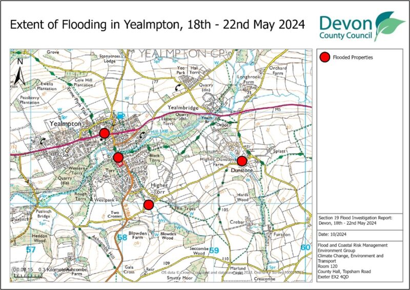
Between 18th and 22 May 2024, significant flooding was experienced across Devon as a result of an intense rainfall event. Watercourses overtopped and drainage systems became overwhelmed from large amounts of surface water runoff, which led to multiple properties flooding in Devon. The worst affected areas were Yealmpton, Tavistock and Wilmington in addition to other locations across the County. In total, 16 properties suffered internal flooding (11 residential and five commercial).
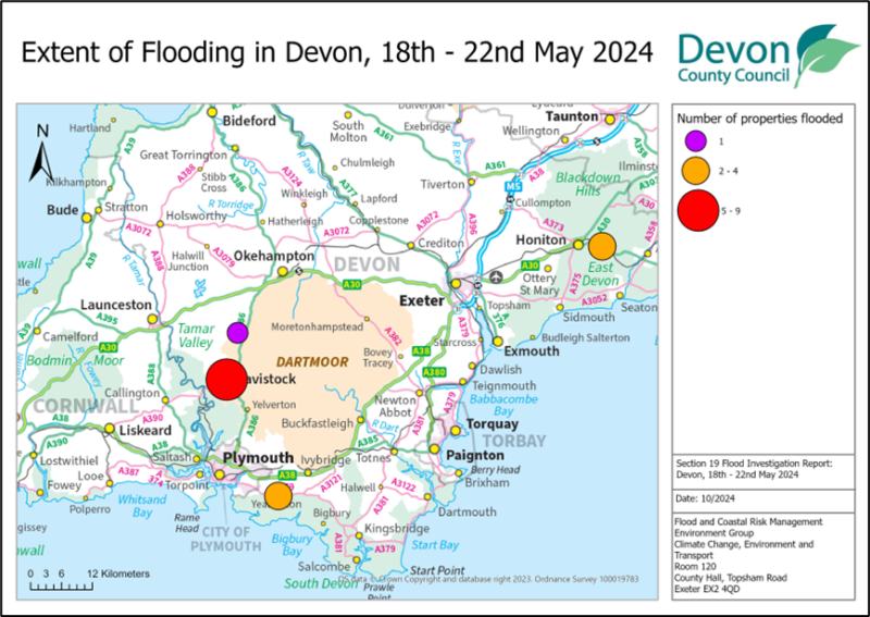
Table 3.1 lists the towns and villages affected on this date together with the reported number of properties flooded in each location. These have been identified on Figure 3.1 above to show the geographical extent of flooding across Devon. It should be noted that the flooded locations have been reported alphabetically and not in any order of priority
| Location | Number of properties flooded | Source of flooding |
| East Devon | ||
| Wilmington | 3 | Surface Water |
| South Hams | ||
| Yealmpton | 4 | Surface Water/Ordinary Watercourse |
| West Devon | ||
| Tavistock | 9 | Surface Water |
| Lydford | 1 | Surface Water |
| Total properties flooded: 16 | ||
3.2 Impacts on the highway network
During the event between 18 May and 22nd May 2024, significant surface water flooding affected the highway network across Devon. Highway drainage systems in several areas, particularly Tavistock, struggled to cope with the drastically increased flows, sometimes causing them to overflow onto the highway. Typically, these highway drainage and sewer systems are not designed to cope with such intense rainfall events. As part of the investigation, it will be recommended that Devon County Council Highways review the highway gullies and consider whether any maintenance issues require attention.
Notable areas of the highway affected include:
Higher Torr, Yealmpton where the road was blocked and made impassable by mud and flood water.
Duke Street and Parkwood Road in Tavistock where surface water on the highway led to property flooding.
3.3 Incident response and recovery
Initial community engagement and drop in events:
When a flood event occurs, it is immediately followed by an emergency response and then recovery phase. There are many roles involved in this process, covered by the Emergency services, Environment Agency, and local authorities. Details of this are included in the Multi-Agency Flood Framework. As LLFA, DCC’s Flood & Coastal Risk Management team becomes involved at the recovery phase, through recovery coordination, community engagement and investigation.
Following any flood event, DCC will engage with relevant District Councils, Risk Management Authorities, local Parish and Town Councils and community members to gather information. This information is shared with other agencies to determine the extent of impact.
Immediate actions taken:
As part of the initial response to the flood event on 18th May and subsequent recovery phase, relevant Risk Management Authorities have been quick to take actions to aid the recovery of communities:
Devon County Council Lead Local Flood Authority: Sent out members of staff to conduct reconnaissance in the affected areas, whilst coordinating with the EA to collate information and build up a picture of the impacts.
Devon County Council Highways: Teams were immediately out in affected areas to clear highway gullies and silt from the roads.
District Councils: East Devon, Mid Devon, West Devon, and South Hams were all affected, assisting communities with Environmental Health issues and supporting the recovery process.
Environment Agency: Monitored the situation from their incident control room. Due to the main sources of flooding being from surface water and ordinary watercourses, no reconnaissance was conducted by the Environment Agency on this occasion.
The EA were also able to focus the Land Management Project team on surveying the South Devon areas affected.
It is hoped that land management advice can be rolled out throughout the catchments to address surface water runoff and help landowners to make more informed decisions around timing of grazing and trafficking of field operations, in addition to identifying any opportunities for Natural Flood Management (NFM) interventions.South West Water (SWW): Will have responded to individual incidents logged with them regarding any sewer flooding issues.
East Devon Flood Incident Extent and Impact
4.1 Wilmington, Widworthy
A total of three properties experienced internal flooding in Wilmington. An intense, very localised rainfall event during a thunderstorm on the evening of 22 May 2024 saw significant floodwaters flow through the community.
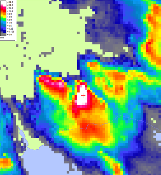
The localisation and intensity are highlighted within radar imagery (Figure 4.1) showing Wilmington receiving the bulk of the rainfall. The rainfall missed all nearby gauges, and the radar is likely to be an overestimate of the rainfall received so it is not possible to provide a return period for the event.
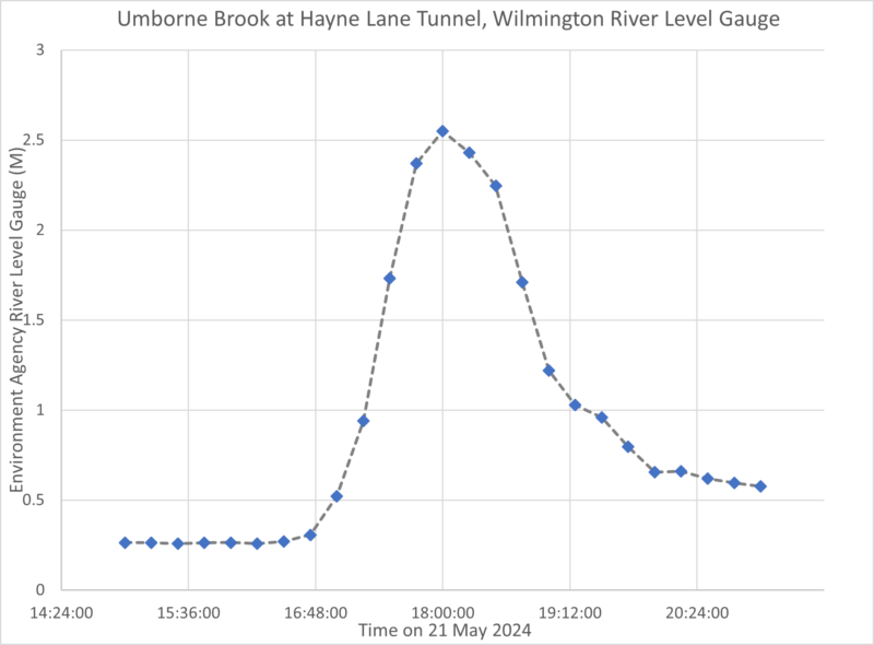
A nearby river level gauge on the Umborne Brook shows steady flows up to 4:45pm with levels at 0.307m rising rapidly to 2.549m at 6pm before falling back to a steady rate at 0.654m at 8pm. This can be seen in Figure 4.2.
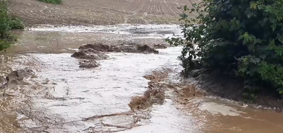
A residential property and the Village Hall along the A35 in Wilmington were flood internally up to 3cm deep. As sheet flows rushed down the A35, highway drainage systems were overwhelmed, many blocked with sediment from adjacent land rendering much of the system ineffectual during the incident. An ordinary watercourse south of the A35 within agricultural land overtopped flowing around a hedgebank and out of a field and quarry access onto the A35, as shown in Figure 4.3. This watercourse is understood to be culverted underneath the A35 before issuing out at the fountain adjacent to Home Farm Hotel. Surface water flood maps appear to be slightly inaccurate and may benefit from adjustments to showgreater flows along the road networks running west to east which conveyed flows during the event and historically.
A single property also reported a few millimetres internally along Hayne Lane with others impacted by flooding to their gardens. As sheet flows rushed down the Category 12 road at high velocity bringing tonnes and tonnes of debris onto Hayne Lane. Hayne Lane was inaccessible following the incident due to material deposits on the road network. Category 12 is the lowest classification of road in Devon, managed under Public Rights of Way.
Historic Flooding
DCC hold no records of previous property flooding in Wilmington. However, the A35 through Wilmington is known to experience overland surface water flows with noted incidents in local press from February 2014 and November 2017.
There are also recorded flood outlines from July 1968 showing a flood flowpath along the Category 12 road off of Hayne Lane.
South Hams Flood Incident Extent and Impact
5.1 Yealmpton
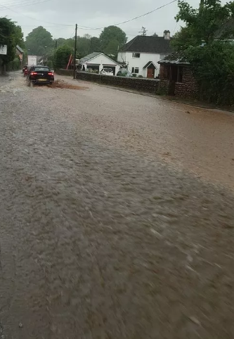
A total of four properties were affected by internal property flooding in Yealmpton. The rainfall was intense and localised. Residents in Ivybridge reported seeing a “cloud burst” over the area around Yealmpton, with residents describing the rainfall as “Biblical”. Three separate areas of Yealmpton were affected: Boldventure, Torr, and Dunstone.
The rainfall was intense and highly localised with rain gauges in nearby Ivybridge and Plympton not indicating significant levels. The Main River level gauge in Yealmpton did not show any significant rise in the river level, indicating that the flooding did not come from the River Yealm.
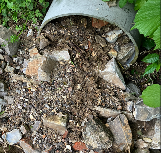
In the Boldventure area near the north end of Ford Road, one property flooded internally from surface water flowing down Ford Road from the screen near Creamery Close. The location is known locally as the water trough. Videos from residents show the watercourse overtopping the culvert and screen and flowing down Ford Road towards Boldventure. Videos and photographs show the water was carrying large quantities of soil and material.
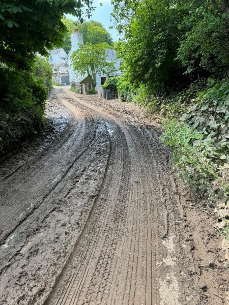
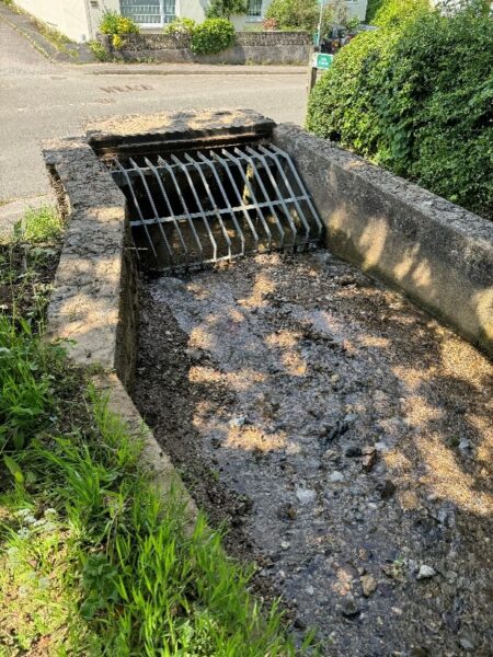
Figure 5.2. Left: Photograph of Boldventure on 20th May 2024, two days after the flooding on the 18th May. Right: Photograph of the screen and culvert near Creamery Close from where the flood water flowed out of bank and down Ford Road.
The property on Boldventure flooded up to 15cm deep internally, with external depths in the garden of over 30cm in places. The water travelled from Ford Road through the back gate and into the property. The Boldventure road was filled with muddy debris and another property’s garage was flooded with a centimetre of water. Other properties on Boldventure and nearby streets had muddy debris left in their driveways and gardens.
In the Higher Torr area of Yealmpton, one property flooded internally from surface water and out of bank flows from an Ordinary Watercourse. The property experienced internal depths of up to 30cm including quantities of mud throughout their ground floor. Surface water entered from the highway through the front gate and flooded the front yard and entered the property.
In Dunstone, one property experienced internal flooding with muddy flows down the road leading into Dunstone from the south. During the event, over 30cm of mud was deposited on the road outside the affected property, with water entering through the front of the property.

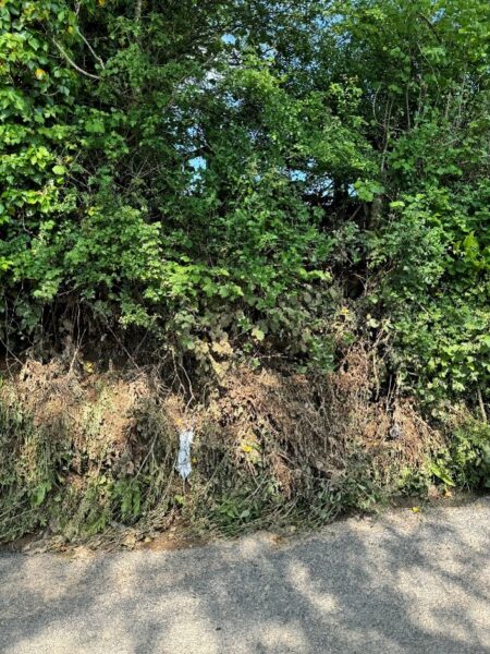
Figure 5.3. Left: Photograph taken 20th May 2024 showing mud deposited by surface water flooding outside a property in Dunstone. Right: A photograph taken 20th May 2024 showing mud on a hedge bank where the surface water that affected Dunstone flowed from.
Historic Flooding
Yealmpton has a history of flooding with the most significant event being 2012 when the Main River flowed out of it banks and flooded multiple properties in the Boldventure and Mill Leat Close areas. Subsequent to that event, the Environment Agency and DCC carried out schemes including Property Flood Resilience and a bund on the Main River.
Details of previous flooding:
November 2012: Property in Boldventure previously flooded due to an Ordinary Watercourse
December 2012:Property in Higher Torr previously flooded due to surface water.
December 2012: Property in Dunstone previously flooded due to surface water.
West Devon Flood Incident Extent and Impact
6.1 Tavistock
Nine properties were flooded internally from surface water in Tavistock on 21st May 2024. Five of the properties affected were in the town centre on Duke Street. All of these properties are commercial buildings, and none had reported previous flooding. Properties on both sides of Duke Street were affected when surface water pooled on the highway and pavements. Three of the properties had water enter through the front door, two had water enter into their basement from the street.
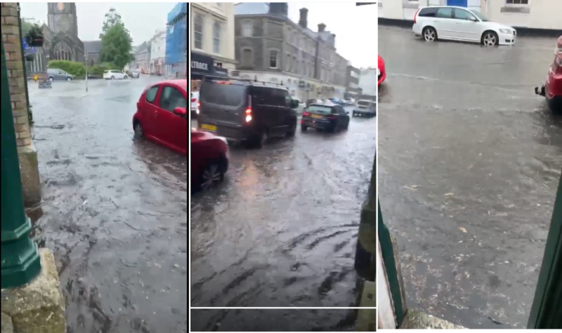
Figure 6.1. Screenshots taken from a video recorded in Duke Street on 21st May 2024 showing the flooding in Tavistock town centre (Credit: Leftfield, Tavistock).
One property on Parkwood Road, Tavistock was flooded internally when surface water entered the front of the house.
Three properties on Hazel Road were flooded internally when surface water entered through the back of the properties from a shared parking area.
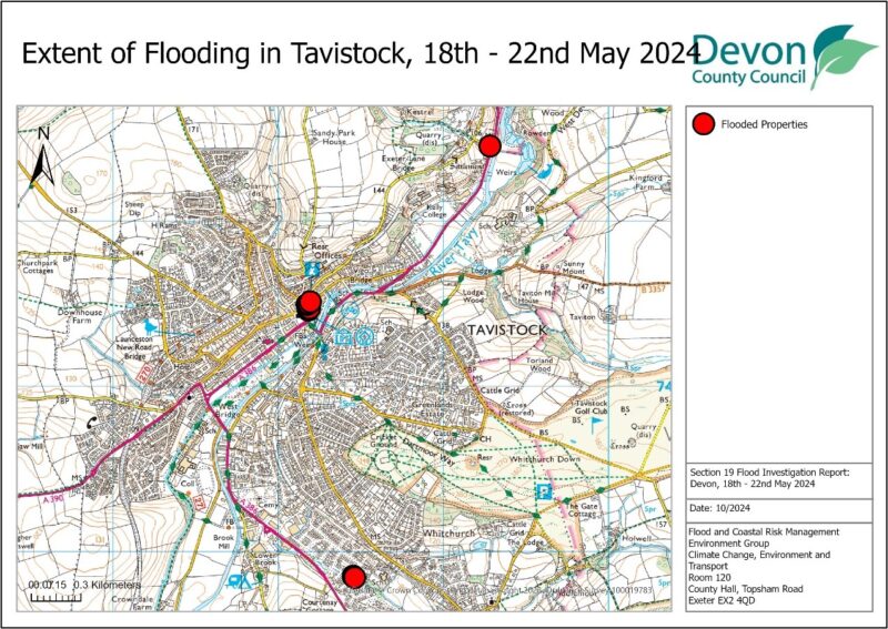
Figure 6.2.: Map showing the approximate locations of flooded properties in Tavistock.
Lydford
One property in Lydford was flooded internally with locally reported depths of up to six feet. Large volumes of debris entered the property and caused damage. The fire service was called and pumped water out of their basement. The residents reported that this was the second time in four years that they had flooded in this manner.
Historic Flooding
Tavistock has some history of flooding with a combination of risk from surface water and the Main River. The Main River caused properties to flood in January 2000. Devon County Council has a record of seven properties flooding from surface water spread across Tavistock. Notably, two properties on Dolvin Road which flooded in 2013 due to surface water.
Recommended Actions
As a result of this investigation report, several recommendations have been made for actions to be considered in specific locations. These are either as a result of initial site or desktop investigations, or the continuation of works or investigations already in progress. DCC as the LLFA will continue to monitor and record all flood incidents that come to our attention and consider this within our action plan and future investment programme. The current action plan can be found on the DCC Flood Risk Management Website at https://www.devon.gov.uk/floodriskmanagement/. Table 10.1 below summarises the recommended actions for this flood incident.
As stated earlier in this document, the purpose of this report is to act as a tool for all of the relevant RMAs to understand and appreciate the extent of flooding in their area and to consider and prioritise those actions relevant to their authority. Due to the extent of flooding, not only from the events covered in this report, the level of recommended actions far exceeds the budgets and resources available to enable them to be delivered immediately. Although we take all flooding issues seriously it should therefore be appreciated that some actions may not be progressed within the timescales expected by some residents or communities. Every effort will be made to progress the actions if and when suitable funding is obtained.
The recommended actions highlighted in this report will be used by the LLFA to monitor progress achieved by the RMAs.
| Action By | Recommended Action |
| General actions recommended for the areas featured in this report: | |
| EA /LLFA / Local communities | Where applicable assist with the development of community emergency/flood action plans. Advice and possible funding are available from Devon Community Resilience Forum to increase community resilience to all affected communities. |
| DCC Highways / National Highways | Review, and where required, carry out maintenance in problem areas to ensure efficient operation of highway drains and culverts. |
| District Council / EA / LLFA | Encourage sustainable drainage practices for new developments to ensure flood risk is managed from new development. |
| Property Owners / LLFA / EA | Consider flood risk to own properties and to install property level protection where necessary in liaison with appropriate Risk Management Authorities. |
| SWW | Continue maintenance regime and consider storm separation where appropriate to ensure efficient operation of public combined and surface water sewers. |
| In addition to the general actions the following should be considered at specific locations: | |
| Action By | Recommended Action |
| EAST DEVON | |
| Wilmington | |
| Environment Agency | Consider any appropriate land management advice and potential enforcement action where necessary for upslope landowners |
| National Highways | To continue to pursue drainage improvement options for the A35 |
| DCC Public Rights Of Way | Repair Category 12 lane onto Hayne Lane with consideration for retaining material on the lane itself |
| SOUTH HAMS | |
| Yealmpton | |
| Environment Agency | Consider any appropriate land management advice and potential enforcement action where necessary for upslope landowners |
| South Hams District Council | Continued maintenance of the culvert and culvert screen near Creamery Close |
| DCC Highways | Highway improvement works have been carried out at Higher Torr subsequent to the flooding. The watercourse adjacent to the highway should continue to be maintained. |
| WEST DEVON | |
| Tavistock | |
| DCC Highways | Investigate drainage improvement works on the A386/Parkwood Road |
| West Devon Borough Council | Investigate maintenance of trees on Oak Road to reduce leaf litter in highway drains. |
Next Steps
The next steps following this report will be for DCC as the LLFA to ensure that the recommended action tables in each chapter are presented to the responsible Risk Management Authority. DCC will consider their actions in line with other priorities and monitor delivery through regular reviews, whilst working in partnership with the EA, District Councils, SWW and the local communities affected.
There is an expectation from DCC of itself and its partners that all authorities involved will cooperate and work together to improve the flood risk in the vulnerable areas identified in this report by completing the recommended actions. As the LLFA, DCC has a responsibility to oversee the delivery of these actions.
Where minor works and quick win schemes have been identified, these will be prioritised and subject to available funding and resources will be carried out as soon as possible by the relevant authority or landowner. Any major works requiring capital investment will be considered through Defra’s Flood Defence Grant in Aid process.
A review of the actions will be carried out by DCC as the LLFA to monitor progress and encourage delivery of recommended actions.