This flood investigation report has been produced by Devon County Council as a Lead Local Flood Authority (LLFA) under Section 19 of the Flood and Water Management Act 2010.
| Version | Undertaken by | Reviewed by | Approved by | Date |
| Draft 1 | Jessica Bishop | Martin Hutchings | 17/07/2024 | |
| Final | Jessica Bishop, Principal Flood and Coastal Risk Officer | Martin Hutchings, Head of Flood and Coastal Risk Management | 18/07/2024 |
This report covers the flooding incident between 2nd and 3rd November 2023 and has identified all flooded properties within the County that we have been able to determine or brought to our attention. Based on the criteria set out in our Local Strategy this single report covers the requirement for a Section 19 Flood Investigation Report for Ide, but also includes details of other flooded locations during this incident period.
Further details on how Devon County Council manages local flood risk can be viewed here:
Devon Local Flood Risk Management Strategy 2021-2027 – Flood Risk Management
1. Introduction
The Flood Risk Regulations 2009 and the Flood and Water Management Act 2010 (the Act) have established unitary and upper tier local authorities as the Lead Local Flood Authority (LLFA) for their area. This has placed a number of responsibilities on the LLFA in relation to flood risk management and in particular Section 19 of the Act which states:
| Flood and Water Management Act 2010: Section 19 – Local Authorities: investigations On becoming aware of a flood in its area, a lead local flood authority must, to the extent that it considers it necessary or appropriate, investigate – which risk management authorities have relevant flood risk management functions, andwhether each of those risk management authorities has exercised, or is proposing to exercise, those functions in response to the flood.Where an authority carries out an investigation under subsection (1) it must – publish the results of its investigation, andnotify any relevant risk management authorities. Flood and Water Management Act (2010), S.19, c.29, London: HMSO |
A ‘Risk Management Authority’ (RMA) means:
(a) the Environment Agency (EA),
(b) a lead local flood authority,
(c) a district council for an area for which there is no unitary authority,
(d) an internal drainage board,
(e) a water company, and
(f) a highway authority.
When considering if it is necessary or appropriate to investigate a flood event Devon County Council (DCC) will review the severity of the incident, the number of properties affected and the frequency of such an occurrence. Devon’s Local Flood Risk Management Strategy clearly sets out the criteria to be used when considering a Flood Investigation Report.
Although not all of the locations in this report meet the significance threshold of 5 or more properties flooded, to ensure that the full extent of the flooding is appreciated and recorded it has been decided to include all locations brought to our attention which experienced any internal property flooding, and also other areas of particular concern.
In partnership with the other RMAs in Devon this report has been produced to comply with legislation and to determine the main causes of the flooding. It should be noted that in order to progress with their flood risk management function DCC has opted to develop this report further by considering the various actions that should be considered by the relevant RMA. DCC as the LLFA will continue to monitor the list of actions with all of the RMAs and will assist in the delivery where practical to do so.
It should be noted that this report is only based on the information brought to the attention of DCC through its professional partners, the media and the public and where further investigation by the authorities have identified additional flooded properties. Therefore, it cannot be guaranteed to contain an exact or exhaustive list of individual properties or affected communities.
Please note, reports of flood depths vary between metric and imperial measures, to avoid giving the impression of precise depth measurements. It has been actively chosen to not convert these into metric measurements and leave as reported to us.
Each affected area or group of smaller areas investigated within this report will have a number of recommended actions to be taken forward by the relevant RMAs or in some cases, by the landowner or local community action group. There are various levels of action that can be taken depending on the severity of the situation and the practical solutions available to reduce the risk of further flooding. The recommended actions will generally fall into one of the following categories:
Delivery of Quick win schemes: a solution that can be implemented quickly by the Risk Management Authorities or Local Authority at relatively low cost; some of these have already been completed as this report has been progressed.
Further investigation/research: Further investigations such as catchment studies and hydrological/hydraulic assessments to understand the flow rates and directional paths and evaluate the extent of flooding. These would provide evidence for future capital investment.
Development of future schemes: Where immediate action is not financially viable or a solution not readily available then a larger scale flood alleviation scheme may be required. In such cases national funding would need to be secured together with additional contributions from others, such as local levy, local authorities and other third parties.
Landowner action: Members of the public who own land adjacent to watercourses have riparian responsibilities and therefore have a duty to maintain their section of watercourse to ensure there is no impediment of flow. Other works to protect their property may also need to be funded by themselves to ensure delivery within their timescales.
Community action: In some cases, it may be prudent for community groups to join forces and deliver and maintain their own local schemes. This may generate further contributions from local levy or the LLFA.
This investigation report will provide a starting point, with suggested actions being further refined in the light of further studies and where possible, through further dialog with the affected communities.
| Recommended Actions: The purpose of this report is to act as a tool for all of the relevant RMAs to understand and appreciate the extent of flooding in their area and to consider and prioritise those actions relevant to their authority. Due to the extent of flooding, not only from the events covered in this report the level of recommended actions far exceeds the budgets and resources available to enable them to be delivered immediately. We take all flooding issues seriously; however, we do need to prioritise in line with available budgets and resources and the level of risk. It should therefore be appreciated that some actions may not be progressed within the timescales expected by some residents or communities. Every effort will be made to progress the actions if and when suitable funding is obtained. The recommended actions highlighted in this report will be used by the LLFA to monitor progress achieved by the RMAs. |
2. Risk Management Authority Responsibilities
2.1 Recording Flood Incidents
LLFAs must record flood incidents as part of their duties under the Flood and Water Management Act. The information below shows the national guidance given as part of the Preliminary Flood Risk Assessment Spreadsheet submission to the EA, which outlines information to be collected by LLFAs.
Information the LLFA must record
Devon County Council (DCC) will record this on the DCC flood incident database:
- Start Date
- Days duration
- Probability
- Main source: Surface water runoff; Groundwater; Ordinary watercourses; Artificial infrastructure; Main rivers; The sea; No data
- Main mechanism: Natural exceedance; Defence exceedance; Failure; Blockage or restriction; or No data
- Main characteristics: Natural flood; Flash flood; Deep flood; Snow melt flood; No data
- Significant consequences:
- To human health (residential properties)
- To economy (non-residential properties)
- To the environment (designated sites flooded)
2.2 Key Responsibilities
RMAs in Devon all have their own roles and responsibilities. The general RMA responsibilities in relation to flood risk and surface water management are outlined below:
The Environment Agency is responsible for managing the risk from the sea, Main Rivers and reservoirs and has a strategic overview role for all flood risk management, making it a key local partner for DCC, especially when managing the risk from combined sources and in the event of a large flood incident. The EA also provides a flood warning service throughout England and Wales in areas at risk of flooding from rivers or the sea.
Devon County Council as the Lead Local Flood Authority is responsible for overseeing the flood risk from Ordinary Watercourses, groundwater and surface water runoff. They are also responsible for consenting to works on Ordinary Watercourses and enforcing the removal of any unlawful structure or obstruction within the watercourse. And, as previously stated they must ensure that a flooding investigation is carried out by the relevant authority and publish a report. DCC must also prepare a Local Flood Risk Management Strategy and maintain a register of flood risk assets.
Local District Councils are classified as land drainage authorities with discretionary powers under the Land Drainage Act, such as the implementation and maintenance of flood defences on ordinary watercourses. They also have powers under the Public Health Act to ensure the removal of any blockage within an ordinary watercourse that is considered a nuisance. As a planning authority they are responsible for the preparation of development plans and making decisions based on planning policy.
Devon County Council as the Highway Authority maintains the highway drainage system to reduce the amount of standing water on the highway. This is achieved by limiting the water on the roads and ensuring that they are kept clear of rainwater; including the maintenance of highway gullies and culverts.
National Highways is responsible for managing, maintaining and improving the Motorway and trunk roads across England and any associated drainage and flood risk.
South West Water (The Water Company) is responsible for the public sewerage network including foul, surface water and combined systems together with any associated assets such as pumping stations, sewage treatment works and combined sewer overflows.
Land/Property Owners that have a watercourse in or adjacent to their land have riparian responsibilities on that watercourse. This means the landowner must:
- Let water flow through their land without any obstruction, pollution or diversion which affects the rights of others.
- Accept flood flows through their land, even if these are caused by inadequate capacity downstream.
- Keep the banks clear of anything that could cause an obstruction and increase flood risk, either on their land or downstream if it is washed away.
- Maintain the bed and banks of the watercourse and the trees and shrubs growing on the banks and should also clear any litter or debris from the channel and banks, even if it did not come from their land.
- Keep any structures, such as culverts, trash screens and debris grills, weirs and mill gates, clear of debris.
The LLFA must also take an overseeing role to ensure that all flood risk is being managed appropriately.
In small, localised groundwater and surface water flooding incidents which do not reach the threshold level to trigger a flood investigation by the LLFA under Section 19, the Local Authorities will work in partnership to consider the appropriate action.All RMAs have a duty to co-operate and to share information in relation to their flood risk management functions.
3. Incident Summary
3.1 Incident Summary
Between 2nd and 3rd November 2023, Storm Ciarán swept through Devon with strong winds and intense rainfall. As a result, significant flooding was experienced in a few isolated parts of Devon. Watercourses were overtopped and drainage systems became overwhelmed from large amounts of surface water runoff. Ide in Teignbridge was the worst affected area, with 6 properties internally flooded. In total, across the county, 20 properties suffered internal flooding (13 residential and 7 commercial). Figure 3.1 shows the extent of the flood event across Devon.
In line with Devon County Council’s Local Flood Risk Management Strategy, this flood investigation report has been produced due to flooded property number thresholds being exceeded in a given location (in this instance, the village of Ide). Other affected locations have been included in this report for completeness and to encompass the whole event which impacted the County. These locations would otherwise not have qualified for an individual flood investigation report and therefore have not been investigated in detail.
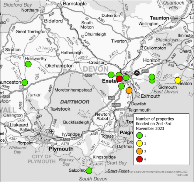
Table 3.1 lists the towns and villages affected on this date together with the reported number of properties flooded in each location. It should be noted that the flooded locations have been reported alphabetically and not in any order of priority.
Table 3.1 List of towns and villages affected.
| Location | Number of properties flooded | Source of flooding |
| Teignbridge | ||
| Ide | 6 | Surface water |
| Kennford | 1 | Main river |
| Powderham, Kenton | 3 | Main river |
| Whitestone | 1 | Ordinary watercourse |
| Exeter | ||
| Redhills | 1 | Surface water |
| St Loyes | 1 | Surface water |
| East Devon | ||
| Harpford | 1 | Ordinary watercourse/surface water |
| Seaton | 2 | The sea |
| Tipton St John | 1 | Main river |
| South Hams | ||
| Salcombe | 1 | The sea |
| Torridge | ||
| Clawton | 1 | Surface water |
| St Giles on the Heath | 1 | Surface water |
| Total properties flooded: 20 | ||
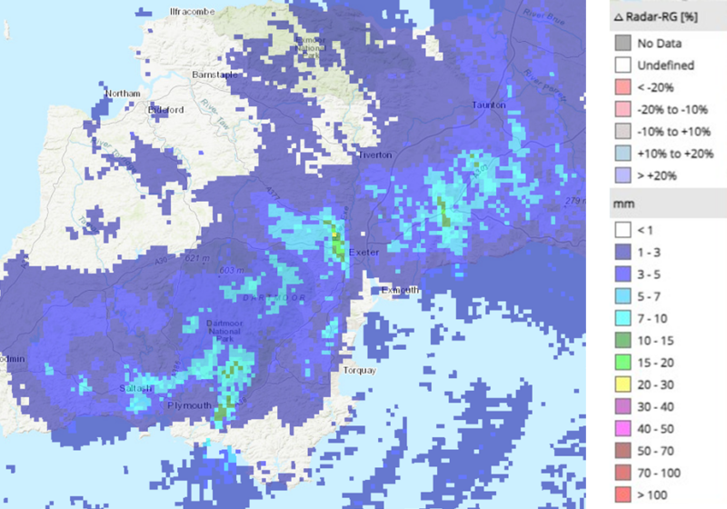
Radar rainfall analysis shows pockets of rain over areas of Devon with levels up to 30mm per hour. Figure 3.2 shows an extract of the radar rainfall analysis from HydroMaster (www.kisters.eu/hydromaster) during the early hours of 2nd November.
3.2 Impacts on the highway network and services
During the event on 2nd November, there were more than 80 reported incidents of fallen trees, flooded roads and landslips on local roads. Over 30 teams of tree surgeons and 12 emergency call-out teams were available where needed. Additional staff were drafted-in especially to help manage the situation from Devon County Council’s Control Centre. 300 schools closed and all of Devon County Council Household Waste Recycling Centres closed, due to high winds and risk of flying debris.
3.3 Incident response and recovery
When a flood event occurs, it is immediately followed by an emergency response and then recovery phase. There are many roles involved in this process, covered by the Emergency services, Environment Agency and local authorities. Details of this are included in the Multi-Agency Flood Framework. As LLFA, DCC’s Flood & Coastal Risk Management team becomes involved at the recovery phase, through recovery coordination, community engagement and investigation.
Following any flood event, DCC will engage with relevant District Councils, Risk Management Authorities, local Parish and Town Councils and community members to gather information. This information is shared with other agencies to determine the extent of impact.
On this occasion, due to the relatively low numbers of properties affected, no community flood ‘drop in’ events were held. However, a meeting was held on site in Ide shortly after the event between DCC, the EA and the Parish Council to gain a better understanding.
4. Flood Incident Extent and Impact
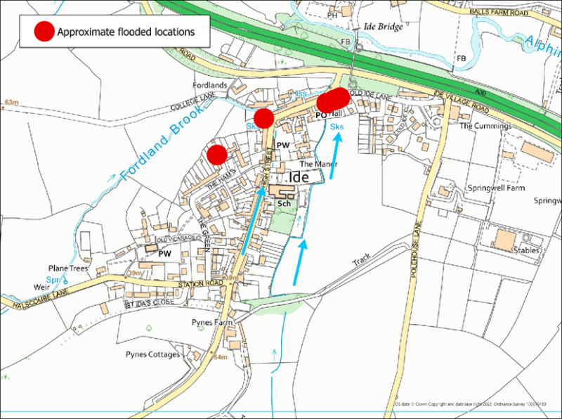
4.1 Ide
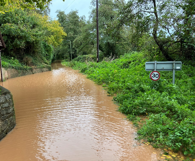
In the early hours of 3rd November 2023, Ide experienced intense rainfall and resulting surface water runoff, causing flooding to several homes and businesses. In total, six properties were internally flooded, consisting of three residential and three commercial properties, including a local pub and the village hall.
Flows were reported from the surrounding fields, where they overtopped garden walls, before travelling through gardens and houses with water levels reportedly at 2 feet high.
An Environment Land Management Officer has subsequently investigated the surrounding catchment. Several areas have been identified where significant overland flows and erosion of soil is being experienced, indicating poor soil structure. Advice has been provided to the Parish and landowners are to be engaged with. In parts of the catchment, overland flows are conveyed through and alongside the highway network, which increases the natural catchment area.
Issues were also identified in the village downstream where changes could be made to enable surface water flows to exit the road and village more quickly and into the watercourse.
Historic Flooding
Ide has suffered regular historic flooding from both surface water and the Alphin Brook watercourse. Below is the known flood history according to local records dating back to 2000:
07 December 2000: Two properties flooded from surface water.
30 May 2008: One property flooded from surface water.
30 December 2013: One property flooded from ordinary watercourse.
16 October 2014: One property flooded from surface water.
4.2 Kennford
One property was flooded from the Main River Kenn, where water was reported to have come up through the floors. This property has a history of previous flooding in 2000 and 2012.
4.3 Powderham, Kenton
Two residential properties were flooded from the Main River Kenn on the outskirts of Kenton, on the Powderham Estate. These properties were also flooded in September 2023 when the area was flooded more extensively affecting a further two nearby properties.
4.4 Whitestone
One property was flooded on the outskirts of Exeter, near Whitestone from an ordinary watercourse. Unconsented building works to culvert the watercourse were in progress at the time, which is likely to have exacerbated the flooding. DCC Flood and Coastal Risk Management team have since been in conversations with the landowner to replace the culvert with an approved structure that will not restrict flows in the watercourse.
4.5 Exeter
In the Matford Home Farm area just outside of Exeter, there was an unconfirmed flooding of a commercial property.
Within the city boundary, two properties were internally flooded from surface water in completely isolated incidents: One in the Redhills area, which has had previous external flooding; In the St Loyes area a further property was flooded internally with the local drainage being overwhelmed in the nearby carpark.
4.6 Harpford
One property was flooded in Harpford from a nearby ordinary watercourse and surface water flows along the adjacent road. The same property is recorded to have previously flooded in 2002 from the nearby watercourse.
4.7 Seaton
One commercial property in Seaton, a café was flooded internally due to wave action. This property does not have a record of any previous flooding. Some public toilets were also flooded and damaged caused where the road was reported to have flooded behind the splash wall, again due to wave action.
4.8 Tipton St John
In Tipton St John the River Otter levels caused flooding to low lying areas including the playing field car park, resulting in internal flooding to a commercial garage. The garage previously flooded from the main river in July and November 2012 and from surface water in 2022.
4.9 Salcombe
A hotel in Salcombe was flooded from the sea through wave action. Although this area has been subject to flooding in the past, the hotel does not have a record as having previously flooded internally.
4.10 Clawton
One property was reported to have flooded from blocked highway drains or the system being overwhelmed. There is no recorded history of property flooding at this location.
4.11 St Giles on the Heath
One property was reported to have flooded with surface water from surrounding fields overwhelming highway drainage and running through the house. Highway drainage was reported to have been blocked. This has been logged with DCC Highways for investigation. There is no recorded history of property flooding at this location.
5. Recommended Actions
As a result of this investigation report, several recommendations have been made for actions to be considered in specific locations. These are either as a result of initial site or desktop investigations, or the continuation of works or investigations already in progress. DCC as the LLFA will continue to monitor and record all flood incidents that come to our attention and consider this within our action plan and future investment programme. The current action plan can be found on the DCC Flood Risk Management Website at https://www.devon.gov.uk/floodriskmanagement/. Table 10.1 below summarises the recommended actions for this flood incident.
As stated earlier in this document, the purpose of this report is to act as a tool for all of the relevant RMAs to understand and appreciate the extent of flooding in their area and to consider and prioritise those actions relevant to their authority. Due to the extent of flooding, not only from the events covered in this report, the level of recommended actions far exceeds the budgets and resources available to enable them to be delivered immediately. Although we take all flooding issues seriously it should therefore be appreciated that some actions may not be progressed within the timescales expected by some residents or communities. Every effort will be made to progress the actions if and when suitable funding is obtained.
The recommended actions highlighted in this report will be used by the LLFA to monitor progress achieved by the RMAs.
| Action By | Recommended Action | How |
| General actions recommended for the areas featured in this report: | ||
| EA /LLFA / Local communities | Increase community resilience to all affected communities. | Where applicable assist with the development of community emergency/flood action plans. Advice and possible funding available from Devon Community Resilience Forum. |
| DCC Highways / National Highways | To ensure efficient operation of highway drains and culverts. | Review and carry out maintenance in problem areas |
| District Council / EA / LLFA | To ensure flood risk is managed from new development. | Encourage sustainable drainage practices for new developments. |
| Property Owners / LLFA / EA | Consider flood risk to own properties. | To install property level protection where necessary in liaison with appropriate Risk Management Authorities. |
| SWW | Ensure efficient operation of public combined and surface water sewers. | Continue maintenance regime and consider storm separation where appropriate. |
| In addition to the general actions the following should be considered at specific locations: | ||
| Action By | Recommended Action | How |
| Ide | ||
| LLFA /DCC Highways | Improve conveyance of surface water from highway into the watercourse. | LLFA to liaise with Highways to consider regular maintenance of verge or permanent solution. |
| EA/LLFA | To consider recommended actions in Land Management Report for Ide. | Continued engagement between the Parish, LLFA and EA |
| DCC Highways | Ensure local network is performing efficiently without detrimental effect on nearby land. | Assess existing drainage arrangement in Ide to identify areas which are exacerbating large overland flows through fields, identifying any opportunities for improvement. |
| Land managers | Consider and improve land management practices to reduce surface runoff and soil erosion. | Take care when choosing what crops to grow and consider risks involved, especially with high risk crops such as maize. Engage with EA and Catchment Sensitive Farming officers where possible for advice. |
6. Next Steps
The next steps following this report will be for DCC as the LLFA to ensure that the recommended action tables in each chapter are presented to the responsible Risk Management Authority. DCC will consider their actions in line with other priorities and monitor delivery through regular reviews, whilst working in partnership with the EA, District Councils, SWW and the local communities affected.
There is an expectation from DCC of itself and its partners that all authorities involved will cooperate and work together to improve the flood risk in the vulnerable areas identified in this report by completing the recommended actions. As the LLFA, DCC has a responsibility to oversee the delivery of these actions.
Where minor works and quick win schemes have been identified, these will be prioritised and subject to available funding and resources will be carried out as soon as possible by the relevant authority or landowner. Any major works requiring capital investment will be considered through the EA’s Medium-Term Plan process.
A review of the actions will be carried out by DCC as the LLFA to monitor progress and encourage delivery of recommended actions.