Contents
Devon Floods 17 September
This flood investigation report has been produced by Devon County Council as a Lead Local Flood Authority (LLFA) under Section 19 of the Flood and Water Management Act 2010.
| Version | Undertaken by | Reviewed by | Approved by | Date |
| Draft 1 | Jessica Bishop
Thomas Aldridge Jago Burris | Martin Hutchings | 22/02/2024 | |
| Final draft | Jessica Bishop | Martin Hutchings | 27/02/2024 | |
| Final | Jessica Bishop
Thomas Aldridge Jago Burris | Jessica Bishop, Principal Flood and Coastal Risk Officer | Martin Hutchings, Flood and Coastal Risk Manager | 29/02/2024 |
| Final Rev A | Jago Burris | Jessica Bishop, Principal Flood and Coastal Risk Officer | John Galt, Flood and Coastal Risk Project Engineer | 13/03/2024 |
This report covers the flooding incident between 16th and 18th September 2023 and has identified all flooded properties within the County that we have been able to determine or brought to our attention. Based on the criteria set out in our Local Strategy this single report covers the requirement for 12 individual Section 19 Flood Investigation Reports together with details of other flooded locations during this incident period.
Further details on how Devon County Council manages local flood risk can be viewed here:
Devon Local Flood Risk Management Strategy 2021-2027 – Flood Risk Management
1. Introduction
The Flood Risk Regulations 2009 and the Flood and Water Management Act 2010 (the Act) have established unitary and upper tier local authorities as the Lead Local Flood Authority (LLFA) for their area. This has placed a number of responsibilities on the LLFA in relation to flood risk management and in particular Section 19 of the Act which states:
| Flood and Water Management Act 2010: Section 19 – Local Authorities: investigations
1) On becoming aware of a flood in its area, a lead local flood authority must, to the extent that it considers it necessary or appropriate, investigate – a) which risk management authorities have relevant flood risk management functions, and b) whether each of those risk management authorities has exercised, or is proposing to exercise, those functions in response to the flood. 2) Where an authority carries out an investigation under subsection (1) it must – a) publish the results of its investigation, and b) notify any relevant risk management authorities. Flood and Water Management Act (2010), S.19, c.29, London: HMSO |
A ‘Risk Management Authority’ (RMA) means:
(a) the Environment Agency (EA),
(b) a lead local flood authority,
(c) a district council for an area for which there is no unitary authority,
(d) an internal drainage board,
(e) a water company, and
(f) a highway authority.
When considering if it is necessary or appropriate to investigate a flood event Devon County Council (DCC) will review the severity of the incident, the number of properties affected and the frequency of such an occurrence. Devon’s Local Flood Risk Management Strategy clearly sets out the criteria to be used when considering a Flood Investigation Report.
Although not all of the locations in this report meet the significance threshold of 5 or more properties flooded, to ensure that the full extent of the flooding is appreciated and recorded it has been decided to include all locations brought to our attention which experienced any internal property flooding, and also other areas of particular concern.
In partnership with the other RMAs in Devon this report has been produced to comply with legislation and to determine the main causes of the flooding. It should be noted that in order to progress with their flood risk management function DCC has opted to develop this report further by considering the various actions that should be considered by the relevant RMA. DCC as the LLFA will continue to monitor the list of actions with all of the RMAs and will assist in the delivery where practical to do so.
It should be noted that this report is only based on the information brought to the attention of DCC through its professional partners, the media and the public and where further investigation by the authorities have identified additional flooded properties. Therefore, it cannot be guaranteed to contain an exact or exhaustive list of individual properties or affected communities.
Please note, reports of flood depths vary between metric and imperial measures, to avoid giving the impression of precise depth measurements. It has been actively chosen to not convert these into metric measurements and leave as reported to us.
Each affected area or group of smaller areas investigated within this report will have a number of recommended actions to be taken forward by the relevant RMAs or in some cases, by the landowner or local community action group. There are various levels of action that can be taken depending on the severity of the situation and the practical solutions available to reduce the risk of further flooding. The recommended actions will generally fall into one of the following categories:
Delivery of Quick win schemes: a solution that can be implemented quickly by the Risk Management Authorities or Local Authority at relatively low cost; some of these have already been completed as this report has been progressed.
Further investigation/research: Further investigations such as catchment studies and hydrological/hydraulic assessments to understand the flow rates and directional paths and evaluate the extent of flooding. These would provide evidence for future capital investment.
Development of future schemes: Where immediate action is not financially viable or a solution not readily available then a larger scale flood alleviation scheme may be required. In such cases national funding would need to be secured together with additional contributions from others, such as local levy, local authorities and other third parties.
Landowner action: Members of the public who own land adjacent to watercourses have riparian responsibilities and therefore have a duty to maintain their section of watercourse to ensure there is no impediment of flow. Other works to protect their property may also need to be funded by themselves to ensure delivery within their timescales.
Community action: In some cases, it may be prudent for community groups to join forces and deliver and maintain their own local schemes. This may generate further contributions from local levy or the LLFA.
This investigation report will provide a starting point, with suggested actions being further refined in the light of further studies and where possible, through further dialog with the affected communities.
| Recommended Actions:
The purpose of this report is to act as a tool for all of the relevant RMAs to understand and appreciate the extent of flooding in their area and to consider and prioritise those actions relevant to their authority. Due to the extent of flooding, not only from the events covered in this report the level of recommended actions far exceeds the budgets and resources available to enable them to be delivered immediately. We take all flooding issues seriously; however, we do need to prioritise in line with available budgets and resources and the level of risk. It should therefore be appreciated that some actions may not be progressed within the timescales expected by some residents or communities. Every effort will be made to progress the actions if and when suitable funding is obtained. The recommended actions highlighted in this report will be used by the LLFA to monitor progress achieved by the RMAs. |
2. Risk Management Authority Responsibilities
2.1 Recording Flood Incidents
LLFAs must record flood incidents as part of their duties under the Flood and Water Management Act. The information below shows the national guidance given as part of the Preliminary Flood Risk Assessment Spreadsheet submission to the EA, which outlines information to be collected by LLFAs.
Information the LLFA must record
Devon County Council (DCC) will record this on the DCC flood incident database:
- Start Date
- Days duration
- Probability
- Main source: Surface water runoff; Groundwater; Ordinary watercourses; Artificial infrastructure; Main rivers; The sea; No data
- Main mechanism: Natural exceedance; Defence exceedance; Failure; Blockage or restriction; or No data
- Main characteristics: Natural flood; Flash flood; Deep flood; Snow melt flood; No data
- Significant consequences:
- To human health (residential properties)
- To economy (non-residential properties)
- To the environment (designated sites flooded)
2.2 Key Responsibilities
RMAs in Devon all have their own roles and responsibilities. The general RMA responsibilities in relation to flood risk and surface water management are outlined below:
The Environment Agency is responsible for managing the risk from the sea, Main Rivers and reservoirs and has a strategic overview role for all flood risk management, making it a key local partner for DCC, especially when managing the risk from combined sources and in the event of a large flood incident. The EA also provides a flood warning service throughout England and Wales in areas at risk of flooding from rivers or the sea.
Devon County Council as the Lead Local Flood Authority is responsible for overseeing the flood risk from Ordinary Watercourses, groundwater and surface water runoff. They are also responsible for consenting to works on Ordinary Watercourses and enforcing the removal of any unlawful structure or obstruction within the watercourse. And, as previously stated they must ensure that a flooding investigation is carried out by the relevant authority and publish a report. DCC must also prepare a Local Flood Risk Management Strategy and maintain a register of flood risk assets.
Local District Councils are classified as land drainage authorities with discretionary powers under the Land Drainage Act, such as the implementation and maintenance of flood defences on ordinary watercourses. They also have powers under the Public Health Act to ensure the removal of any blockage within an ordinary watercourse that is considered a nuisance. As a planning authority they are responsible for the preparation of development plans and making decisions based on planning policy.
Devon County Council as the Highway Authority maintains the highway drainage system to reduce the amount of standing water on the highway. This is achieved by limiting the water on the roads and ensuring that they are kept clear of rainwater; including the maintenance of highway gullies and culverts.
National Highways is responsible for managing, maintaining and improving the Motorway and trunk roads across England and any associated drainage and flood risk.
South West Water (The Water Company) is responsible for the public sewerage network including foul, surface water and combined systems together with any associated assets such as pumping stations, sewage treatment works and combined sewer overflows.
Land/Property Owners that have a watercourse in or adjacent to their land have riparian responsibilities on that watercourse. This means the landowner must:
- Let water flow through their land without any obstruction, pollution or diversion which affects the rights of others.
- Accept flood flows through their land, even if these are caused by inadequate capacity downstream.
- Keep the banks clear of anything that could cause an obstruction and increase flood risk, either on their land or downstream if it is washed away.
- Maintain the bed and banks of the watercourse and the trees and shrubs growing on the banks and should also clear any litter or debris from the channel and banks, even if it did not come from their land.
- Keep any structures, such as culverts, trash screens and debris grills, weirs and mill gates, clear of debris.
The LLFA must also take an overseeing role to ensure that all flood risk is being managed appropriately.
In small, localised groundwater and surface water flooding incidents which do not reach the threshold level to trigger a flood investigation by the LLFA under Section 19, the Local Authorities will work in partnership to consider the appropriate action.
All RMAs have a duty to co-operate and to share information in relation to their flood risk management functions.
3. Incident Summary
3.1 Incident Summary
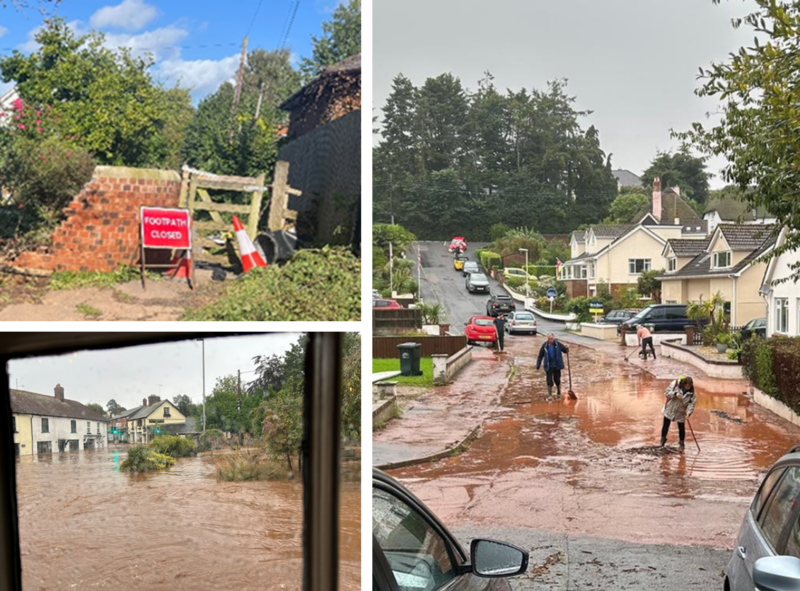
On Sunday 17th September, significant flooding was experienced across Devon as a result of an intense rainfall event. Watercourses overtopped and drainage systems became overwhelmed from large amounts of surface water runoff, which led to multiple properties flooding in Devon. The worst affected areas were Kenton, Exeter and Topsham, Harberton, Harbertonford and Cullompton, in addition to many other locations across the County. In total, 272 properties suffered internal flooding (238 residential and 34 commercial).
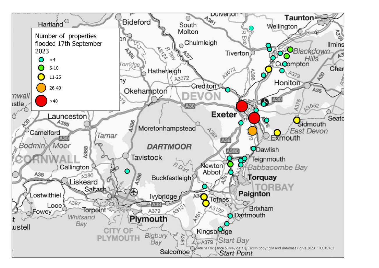
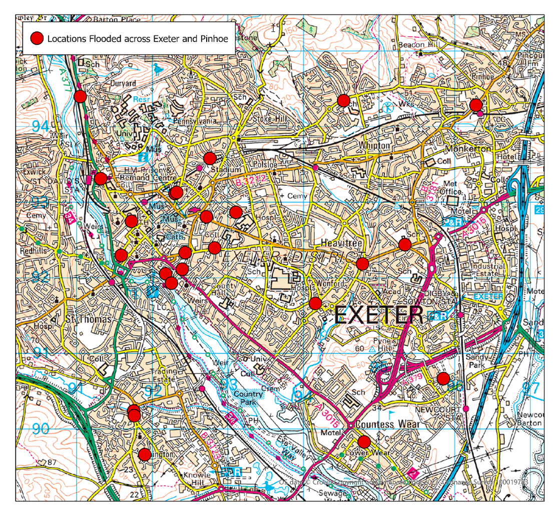
Table 3.1 lists the towns and villages affected on this date together with the reported number of properties flooded in each location. These have been identified on Figure 3.1 above to show the geographical extent of flooding across Devon. It should be noted that the flooded locations have been reported alphabetically and not in any order of priority.
Table 3.1 List of towns and villages affected
| Location | Number of properties flooded | Source of flooding |
| East Devon | ||
| Knowle Village, Budleigh Salterton | 11 | Surface water |
| Clyst Honiton | 1 | Surface water |
| Clyst St Mary | 3 | Surface water |
| Dulford | 4 | Surface water/ordinary watercourse |
| Sidmouth | 12 | Surface water and sewerage |
| Woodbury | 1 | Surface water and sewerage |
| Exeter | ||
| Exeter | 47 | Surface water |
| Topsham | 48 | Surface water |
| Teignbridge | ||
| Dawlish | 3 | Surface water/Groundwater |
| Kenton | 32 | Surface water/ordinary watercourse |
| Kennford | 1 | Surface water |
| Wider Kenton | 5 | Main River/Surface Water |
| Kingsteignton | 1 | Surface water |
| Kingskerswell | 1 | Surface water |
| Newton Abbot | 7 | Surface water |
| Shaldon | 1 | Surface water/ordinary watercourse |
| Stokeinteignhead | 3 | Surface water |
| Teignmouth | 2 | Surface water (unconfirmed) |
| Teignharvey | 1 | Surface water |
| South Hams | ||
| Dartmouth | 2 | Surface water |
| Harberton | 24 | Surface water/ordinary watercourse |
| Harbertonford | 15 | Main River/Surface Water |
| Strete | 1 | Surface water |
| Stoke Fleming | 4 | Surface water/ordinary watercourse |
| Week | 1 | Surface water/ordinary watercourse |
| Mid Devon | ||
| Ashill | 6 | Surface water |
| Bampton | 1 | Surface water |
| Blackborough | 1 | Surface water/ordinary watercourse |
| Bradninch | 4 | Surface water |
| Cullompton | 16 | Surface water/ordinary watercourse/main river |
| Culmstock | 6 | Surface water/ordinary watercourse |
| Newton St Cyres | 1 | Surface water |
| Sampford Peverell | 0 | Surface water |
| Uffculme | 1 | Surface water |
| Uplowman | 2 | Surface water |
| Willand | 2 | Surface water |
| West Devon | ||
| Buckland Monachorum | 2 | Surface water |
| Total properties flooded: 271 | ||
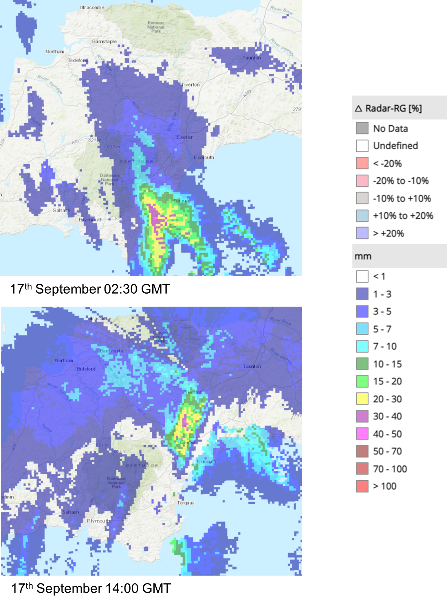
Radar rainfall analysis shows pockets of rain over areas of Devon with levels up to 70mm per hour. Figure 3.2 shows an extract of the radar rainfall analysis during the flood event from HydroMaster (www.kisters.eu/hydromaster) during the early hours and mid-afternoon of 17th September. The analysis shows no change in the 14:00 rainfall image for at least 30 minutes, suggesting that the intense rainfall lingered, adding to the overwhelming of the local drainage systems.
3.2 Impacts on the highway network
During the event on 17th September, significant surface water flooding affected the highway network across Devon. Highway drainage systems in several areas, particularly Topsham and Exeter, struggled to cope with the drastically increased flows, sometimes causing them to overflow onto the highway. Typically, these highway drainage and sewer systems are not designed to cope with such intense rainfall events. As part of the investigation, it will be recommended that Devon County Council Highways review the highway gullies and consider whether any maintenance issues require attention.
Notable areas of the highway affected:
- Major Flooding closures/ roads impassable:
- A375 Sidbury
- A38 Burlescombe
- A380 Kingskerswell/ Penn Inn
- Honiton Road Exeter
- A379 Kenton
- Rydon Lane Exeter
- High St. Halberton
- The Strand Dawlish
- B3181 Merry Harriers (Fire service reports that water levels were up to car door levels)
- A376 Clyst St Mary to Clyst St George
- Station Road Willand
- J30 A376 Sidmouth Road saw flooding which impacted the M5 Northbound slip road
- Major Roads blocked by trees: Teign Valley Road.
- Landslides
- A381 at Halwell, fire engine and two vehicles stuck, 8 tonnes of mud removed from road by fire service/ DCC contractors.
- Landslide Little Coombe Farm, Dittisham.
Several reports were received of lifted manhole covers, and a large number of calls were referred to South West Water regarding sewage system related issues.
In total, 147 external calls received by Devon County Council’s customer call centre midnight-midnight on Sunday 17th September. Call volumes dropped off from approximately 11pm, with the majority of surface water on the highway network subsiding by the following morning.
3.3 Incident response and recovery
Initial community engagement and drop in events:
When a flood event occurs, it is immediately followed by an emergency response and then recovery phase. There are many roles involved in this process, covered by the Emergency services, Environment Agency and local authorities. Details of this are included in the Multi-Agency Flood Framework. As LLFA, DCC’s Flood & Coastal Risk Management team becomes involved at the recovery phase, through recovery coordination, community engagement and investigation.
Following any flood event, DCC will engage with relevant District Councils, Risk Management Authorities, local Parish and Town Councils and community members to gather information. This information is shared with other agencies to determine the extent of impact.
Flood ‘drop in’ events were held in Kenton, Topsham and Harberton over September and October 2023 to provide an opportunity for affected residents to share information about the events and to get help and advice. This information has been used to piece together what is known about the flood extent and mechanisms and to help inform any recommended actions to take forward.
Immediate actions taken:
As part of the initial response to the flood event on 17th September and subsequent recovery phase, relevant Risk Management Authorities have been quick to take actions to aid the recovery of communities:
Devon County Council Lead Local Flood Authority: Sent out members of staff to conduct reconnaissance in the affected areas, whilst coordinating with the EA to collate information and build up a picture of the impacts.
Devon County Council Highways: Teams were immediately out in affected areas to clear highway gullies and silt from the roads.
District Councils: East Devon, Teignbridge, Exeter, Mid Devon, West Devon and South Hams were all affected, assisting communities with Environmental Health issues and supporting the recovery process.
East Devon’s Steet Scene carried out clean up operations around Knowle Village and Clyst St Mary, where flooding carried debris and mainly affected roads.
Teignbridge assisted with the clean-up at Kenton, supplied additional sandbags and provided skips for disposing of damaged goods.
South Hams supported the communities of Harberton and Harbertonford with the clearing of debris and helping them get back on their feet.
Environment Agency: Monitored the situation from their incident control room. Due to the main sources of flooding being from surface water and ordinary watercourses, no reconnaissance was conducted by the Environment Agency on this occasion.
The EA were also able to focus the Land Management Project team on surveying the South Devon areas affected.
It is hoped that land management advice can be rolled out throughout the catchments to address surface water runoff and help landowners to make more informed decisions around timing of grazing and trafficking of field operations, in addition to identifying any opportunities for Natural Flood Management (NFM) interventions.
South West Water (SWW): Will have responded to individual incidents logged with them regarding any sewer flooding issues.
4. East Devon Flood Incident Extent and Impact
4.1 Knowle Village, Budleigh Salterton
11 properties reported flooding in Knowle Village near Budleigh Salterton, primarily affected by surface water and muddy runoff from agricultural land from the east, along the B3178 down into Knowle Road. Highway drainage along the B3178 was buried with mud from the runoff leaving no outlet for surface water flows.
Many of the properties reported low level flooding with seepage through airbricks and dampness in rooms. Had highway drainage systems not become silted up with mud it is plausible that many of the properties would have avoided impacts internally. The Environment Agency land management team have been notified of the issue and where appropriate will follow up with the local landowners to investigate options for reducing the risk of similar incidents. There is no record of historic surface water flooding incidents impacting upon property.
4.2 Clyst St Mary
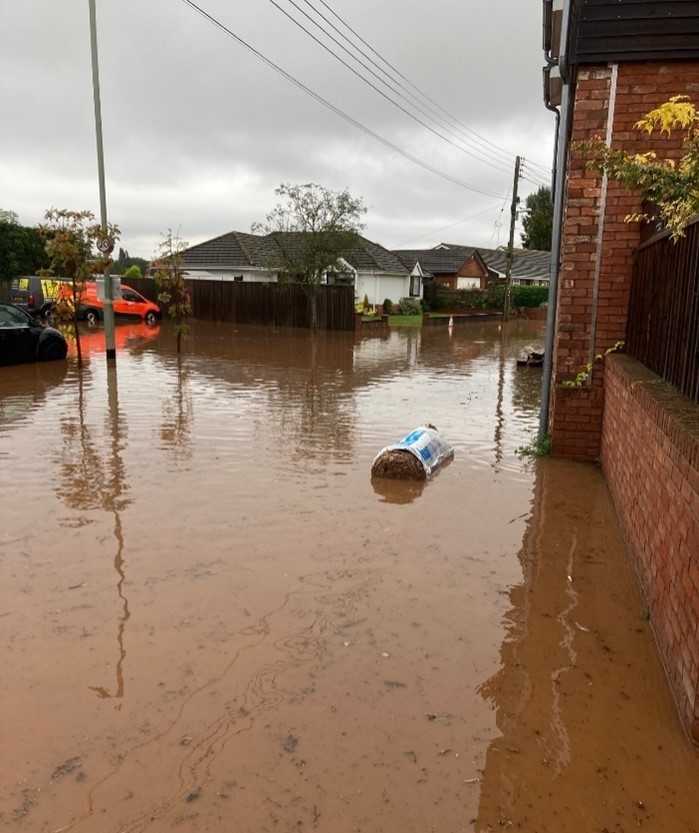
Heavy rainfall between approximately 2-3pm on Sunday 17th September caused flooding from surface water to three properties in Clyst St Mary (One commercial and two residential). The River Clyst levels where high during and following the event, which may have prevented surface water discharging into the river via the drainage through the flood embankment. Standing water was still present in places two days after the event. The road was also flooded at Clyst St Mary roundabout, cutting off access to the village from the main road. It was reported that issues with the local pumping station were affecting resident’s toilets for a few days after the event, being unable to drain/flush.
The SWW pumping station at Clyst St Mary consists of two pumps: one automatic and one manual. It was speculated by residents that these were not working, or at least not initially. SWW officers attended the site and confirmed to residents that these pumps were in fact working at the time of the incident. SWW engineers then altered the control philosophy to maximise the volumes being passed forward to reduce the flooding.
Along Frog Street, no properties were flooded but large amounts of mud and silt were deposited on the road. DCC Highways carried out clearance works here following the event. Due to the materials washed down from the surrounding catchment, the Environment Agency Land Management Team have surveyed the area to identify any problems and to follow up with land management advice and monitoring over the autumn and winter period.
The Environment Agency’s recently completed flood defence scheme for the River Clyst operated effectively and no properties in the village were reported to have flooded from the main river.
Historic Flooding
Clyst St Mary has suffered regular historic flooding from both the River Clyst, tidal impacts and surface water. Below lists the known flood history according to local records dating back to 2000:
7 December 2000: 1 property flooded from unknown source.
14 November2002: 1 property flooded from River Clyst.
13 December 2008: 1 property flooded from unknown source.
21 November 2012: 5 properties flooded from tidal surge.
09 January 2016: 1 property flooded from surface water.
21 November 2016: 4 properties flooded from surface water.
26 December 2017: 1 property flooded from surface water.
Clyst St Mary has previously been subject to a Section 19 flood investigation report with actions to further investigate the flooding mechanisms. Two of the affected properties on this occasion have been flooded before in the 1970s from the River Clyst but not from surface water.
4.3 Dulford, East Devon
Three properties in Dulford reported internal flooding with two more properties experiencing near misses. Two properties on the eastern side of the A373 were flooded through the rear of the property to depths of around 1-2cm. The SWW pumping station was also affected by exceedance flows and surface water runoff, however it is unclear the impacts that this has had on the pumping station itself. Residents noted that SWW had undertaken some recent works and that there had been some clearance of overgrowth within watercourses which they believed to have helped reduce the potential impact.
The River Weaver was running bankfull with some overtopping during peak flows. Figure 4.2 shows post peak flows looking downstream above the soffit level of the bridge crossing the A373 (Grid Ref: 306989, 105978).

Downstream of the bridge flows enter agricultural land where the channel narrows and flows were conveyed into the floodplain area (see figure 4.3). The channel appears to have moved historically. Due to existing works in the catchment under the DEFRA funded Devon Resilience Innovation Project, contact has already been made with the landowner to look at options for enhancing the immediate downstream area adjacent to the structure. This will aid flows under the upstream structure and further downstream to restore the channel to its historic course. Options will also be considered for upstream natural flood management measures in the Kerswell and Dulford area.
A single property southeast of Dulford toward Crammer Cross on the A373 reported flooding to their garden and flooding of external outbuildings from road and field runoff. The event was generally in line with national surface water flood risk mapping for the Dulford area.
Historic Flooding
16 October 2014: One property reported flooding from ordinary watercourse overtopping.
4.4 Sidmouth
Three Properties south of Manor Road, just off Station Road, Sidmouth, experienced internal flooding of a few mm where it backed up through their drainage, which connects into SWW combined sewer network. It is understood a similar but more significant incident occurred in July 2021 where it was evident to residents that foul sewage had backed up, following which repairs were undertaken by SWW. It is believed that a similar mechanism of flooding re-occurred on 17 September 2023.
Three commercial properties toward the northern extent of Sidmouth High St reported internal flooding from surface water flows. One of which experienced flooding to their basement and the other two saw minimal ingress under their shop door fronting the High Street. These properties are level with the road network which during the high rainfall event conveyed flows into the properties.
One property on Coburg Road reported surface water flows down Coburg Road into their drive and ingress into their ground floor spaces.
A single property in Trinity Court reported seepage internally from where flows had pooled in the car park. SWW are currently investigating the source of the flooding.
An individual property at Yardelands in Sidmouth reported flooding associated with the SWW network and surface water from the local footpath. SWW have since undertaken some minor works to help reduce the risk of surface water flows entering the property.
SWW reported flooding to two properties at Fleming Avenue, Sidford and a single property in Temple Street, Sidmouth.
Surface water flooding to external areas and an external garage to a depth of a few inches for two properties were reported in Pathwhorlands with the primary flow path from the adjacent industrial estate.
Historic Flooding
1 December 2000: 1 property from an ordinary watercourse
7 December 2000: 3 properties from an ordinary watercourse
24 May 2002: 2 properties from surface water on Temple Street
13 December 2008 : 2 properties from an ordinary watercourse
30 January 2009: 3 properties from surface water in Lower Woolbrook area
7 July 2012: 3 properties from surface water and sewerage near Milford Road
21 November 2012: 2 from surface water in Lower Woolbrook area
5 February 2014: 3 from surface water
15 November 2014: 18 properties from surface water
19 November 2016: 1 property from surface water on Boughmore Road
23 November 2019: 2 from surface water in Lower Woolbrook Area
16 May 2021: 1 from surface water at Bowd
28 June 2021: 1 property from sewerage off Manor Road
12 July 2021: 1 property from surface water/sewerage off Manor Road
20 October 2021: 1 from surface water at Bowd
4.5 Clyst Honiton
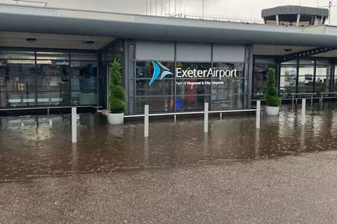
Exeter Airport experienced surface water flooding of their terminal building to a depth of a few centimetres internally, with external depths shown in Figure 4.4. The airport reported closure and cancellation of flights on Sunday 17th September at 2.30pm until the early hours of Monday 18th September, as summarised in their press release on 18th September 2023 at https://exeter-airport.co.uk/airport-reopens-after-flash-flood-shuts-terminal/
4.6 Cranbrook
A single property off Young Acres Road reported internal flooding of a few cm from groundwater and surface water runoff. Investigations suggest long ongoing issues with the private surface water drainage network here, leaving ground conditions wet throughout summer months. Near misses also occurred multiple times following the September event. It is understood the developer has undertaken private drainage works to reduce the risk of this happening for other properties previously and is looking to do so for the affected property in this incident as well.
External flooding was reported on Crannaford Lane close to the access to Cranbrook Education Campus where ordinary watercourse flows run unconstrained from the west out onto the road and then picked up by drainage within the road network. An enforcement investigation remains ongoing due to the infilling of the ordinary watercourse at Luccombe Oak which is exacerbating this issue. A proposal to address this issue by the riparian owner has now been provided to the LLFA for comment.
4.6 Woodbury
The local primary school reported flooding from overland flows of an unknown source coming from land to the east of the school. This impacted upon the school reception, toilets and hall. The school has experienced a number of low-level incidents within the last six months. SWW wastewater team have investigated, concluding that there are no issues with the local sewer network and that improvements to the management of surface water are required to reduce the risk of flooding.
5. Exeter Flood Incident Extent and Impact
The intense rainfall that passed through Exeter, affected many areas across the city, including Pinhoe and Topsham. In total, 96 properties were flooded in the Exeter City Council area.
5.1 Central and Greater Exeter
Each location affected on 17th September across the main Exeter area appears to be from very localised surface water runoff and the overwhelming of the local drainage systems. Many roads were flooded and impassable, but this section of the report concentrates on internal property flooding. 47 Properties were internally flooded from surface water in the Exeter area, excluding Topsham. Figure 5.1 shows the extent of isolated incidents across the city.
A drop in session for affected residents of the Topsham and Exeter areas was held in October 2023 to gain feedback on the flood event and for Risk Management Authorities to provide advice and assistance.
The flood event across Exeter has been broken down into the following areas:
Cowley Bridge
Four residential properties were flooded on Cowley Bridge Road, assumed to be from surface water. There is no history of property flooding at this location.
St Davids
Two residential properties off St David’s Hill were flooded from surface water, with the properties lying much lower than the main road. There is no history of property flooding in this location.
One property was also reported to have flooded below the Iron Bridge from surface water.
Tudor Street
In Tudor Street, one property suffered flooding when the nearby leat overflowed, with sewage reported in the flood water. There is no history of property flooding at this location.
Cowick Street
Four properties were flooded in Cowick Street from surface water flows down Dunsford Road. This location is known for highway flooding with some history of property flooding too.
Alphington
Three properties were reported to have flooded, in three separate locations across Alphington, all from surface water. There is no history of property flooding from surface water at these locations.
Beacon Heath
The Children’s Centre in Beacon Heath was flooded significantly from surface water. The property has flooded repeatedly in the past and the flood doors at the front of the property prevented water ingress, however flood waters came in via a side door on this occasion.
Pinhoe
Two properties were internally flooded from surface water flows on Main Road, Pinhoe, including one where Property Flood Resilience measures failed. There is currently an ongoing investigation by DCC into the local drainage and sewerage system here to determine ownership of a local pipe conveying water. This particular area has a history of frequent flooding.
St James
Four properties flooded from surface water on Victoria Street in the St James area. Properties are recorded to have flooded in the past here from surface water in 1972.
Longbrook Street
Five properties were flooded in the Longbrook Street area, which has a history of frequent flooding form surface water. On this occasion, an additional property was flooded which according to records has not flooded previously.
Devon County Council are currently in the process of delivering a Property Flood Resilience Scheme in the area, which is hoped to be completed in late spring 2024.
Newtown
The Triangle Car Park in the City Centre was affected by surface water and sewerage, with three properties flooded. One property was reported to have flooded in the nearby Clifton area with others in the Clifton Road area fortunately protected by existing Property Flood Resilience (PFR) measures. Near misses were also reported on Clifton Road with bow waves resulting from vehicles passing through the flood waters.
The Triangle car park area has a history of flooding, with the most recent notable event in October 2014 when eight properties were internally flooded.
Mount Radford
Two properties were affected along Magdalen Road and Magdalen Street, including the Mount Radford Pub which was impacted but able to open up again shortly after the incident. Previous flooding incidents have been recorded in both locations.
Holloway Street area
The low spot in Holloway street was affected by surface water flows, with properties flooded on roads either side, from Roberts Road down towards Collaton Hill and Crescent. Seven properties in total were flooded.
This area has suffered flooding previously but not to the extend recorded on this occasion.
Heavitree
One property was flooded in the Dryden Road area and four properties were flooded for the second time in four months in Quarry Lane. On Honiton Road at the bottom of Quarry Lane, the Northbrook watercourse is culverted underneath Honiton Road. It is believed that excessive surface water flows overwhelmed the highway drainage here and were unable to get into the watercourse. This caused significant ponding in the area making the road impassable.
Devon County Council continue to proceed with modelling the Northbrook watercourse at this location, including the highway drainage to look at possible improvement works.
No properties were affected internally at Ringswell Avenue, as in May. However, it has been reported that water came close on this occasion.
Sowton and Newcourt
The car park at IKEA was reported to have flooded on social media. One property nearby suffered flooding from surface water to the garage but was not flooded internally. Investigations are currently in progress by IKEA and DCC into the local drainage.
The Smyth’s toy shop was also reported on social media to have had minor surface water ingress through the front doors. The Exe Vale Tesco store was also reported to have been affected. There is no history of internal flooding at these locations.
Countess Wear
During the rainfall event, significant surface water was experienced on the Countess Wear roundabout and Topsham Road. One property was flooded internally in between Countess Wear Roundabout and Topsham. There is no history of flooding at this location.
Exeter Historic Flooding
Exeter has a history of significant flooding from the River Exe. However, since the 1970s flood scheme and the more recent improvements carried out by the Environment Agency, most flooding has occurred from surface water and minor watercourses.
Surface water flooding dating back to 2000
01 October 2000: 1 property flooded in Alphington
14 November 2002: 1 property flooded in Cowley
29 April 2003: 1 property flooded in Pinhoe
29 April 2008: 2 properties flooded across Exeter
30 May 2008: 1 property flooded in Exwick
06 June2009: 3 properties flooded in Whipton/Newtown
26 August 2011: 4 properties flooded across Exeter
21-24 November 2012:
16 properties flooded from fluvial and surface water, as reported in the Devon Floods, November 2012 Section 19 report.
December 2013 – February 2014:
34 properties flooded from surface water and a tidal surge, as reported in the Devon Winter Floods, December 2013 – February 2014 Section 19 report
16 October 2014:
69 properties flooded across Exeter from surface water and ordinary watercourses, as reported in the Exeter 16th October 2014 Section 19 report.
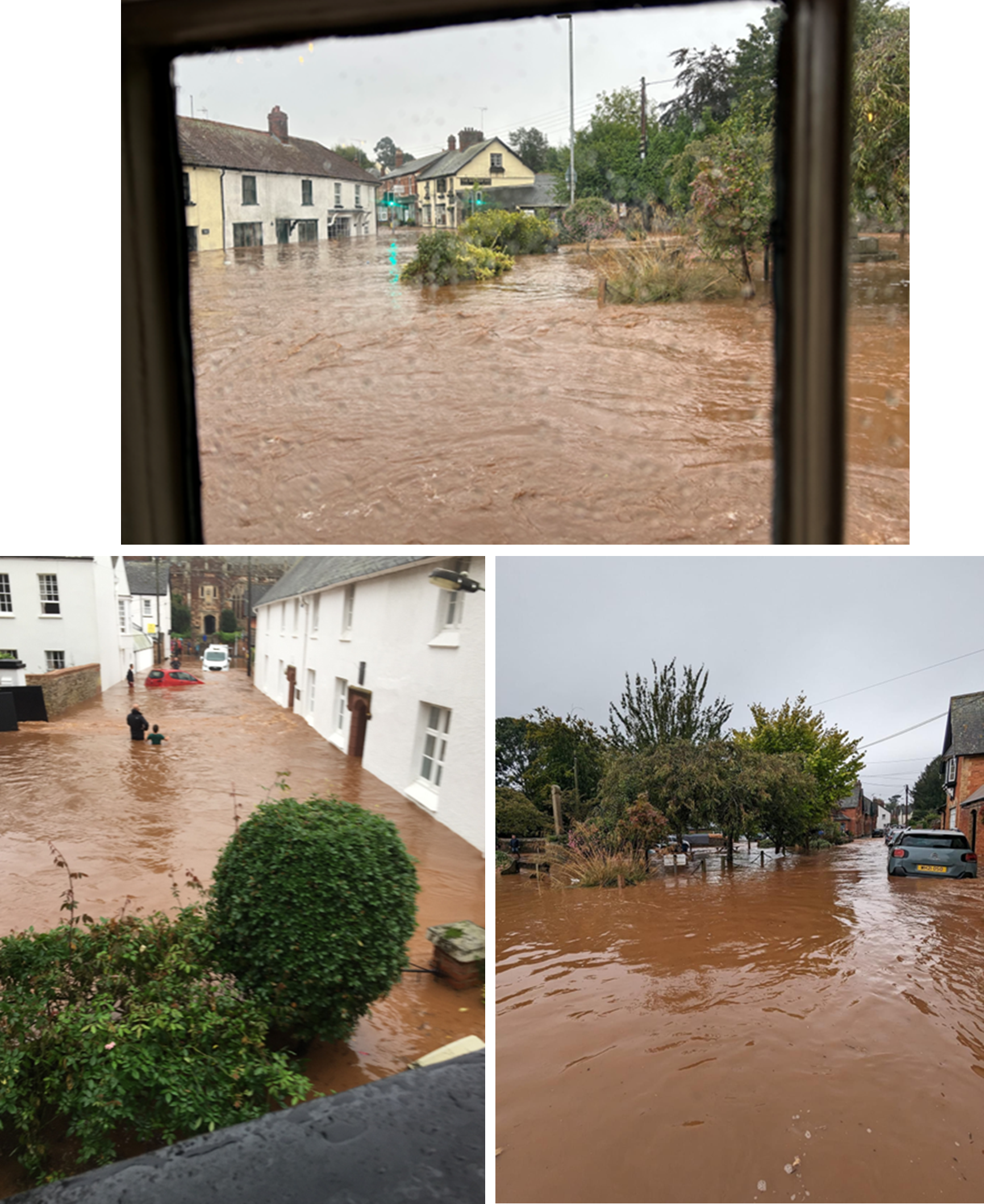
5.2 Topsham
Heavy rainfall between approximately 2-3pm on Sunday 17th September caused significant surface water runoff, overwhelming local drainage systems. 49 properties are recorded to have flooded in Topsham, including 37 residential and 12 commercial properties. At the time of flooding, the tide was low and river levels were reported as normal. Affected properties flooded due to surface water on roads and roof drainage, where many properties have low lying rear courtyards with small drainage systems. Many properties have door thresholds several steps down from the road level and basements where water leaked/seeped through. More than one property had manholes situated inside the property, backing up from the highway drainage system and sewer network. It is also reported that power cuts affected individual properties in Topsham as a result of the flooding.
Due to the flooding in Clyst St Mary, traffic cut off from that route came through Topsham, adding to bow waves entering properties in the main streets.
With the onset of flooding happening so quickly, there was little that could be done by property owners to prepare, with some not having time to deploy their own flood barriers. A sandbag store is available in Topsham, which is overseen by the local flood group, but feedback shows that it was not widely known by residents how to access this.
The impact of flooding in Topsham effected several isolated pockets where the causes were very localised. Figure 5.2 shows the affected areas across the town.
A drop in session for affected residents of the Topsham and Exeter areas was held in October 2023 to gain feedback on the flood event and for Risk Management Authorities to provide advice and assistance.

The flood event across Topsham has been broken down into the following areas:
The Strand
The Strand area of Topsham is usually subject to tidal flood risk and many properties have flood barriers for this purpose. On 17th September, surface water flooded the street and found its way into properties via the rear or up through internal drainage systems. Eight residential properties in the area are reported to have flooded. Anecdotal reports describe the water level on The Strand to be ‘knee deep’ in addition to roof water draining directly into property courtyards.
Ferry Road:
In Ferry Road, another area usually affected by the tide, 12 properties (two commercial, 10 residential) were reported to have flooded. Water levels were reported as “very high” in the road, but no measured levels are available.
Surface water was reported to have travelled down Follet Road, collecting at the bottom of the hill. This area was reported as having standing water as early as 10am on Sunday 17th September and is reported to be regularly cut off due to standing water on the road. On this occasion levels were significant enough to enter properties and write off several parked cars.
Many local residents also report a SWW pumping station in the area to have either not been working or to have been overwhelmed.
On Ferry Road, once again roof drainage in addition to flows from the road were reported to be the main source, including sewage backing up inside properties and causing damage.
Denver Road:
Three residential properties were flooded in Denver Road from surface water. It has not yet been confirmed if water came in from the front of the properties or the rear.
Bridge Inn:
The Bridge Inn pub on Bridge Hill just on the outskirts of Topsham was reported to have flooded internally from surface water.
Monmouth Street:
Surface water was reported to have flowed down Monmouth Street towards houses, causing internal flooding to at least four residential properties. Surface water collected on the terraced roof drainage system also adding to the collection of surface water in rear gardens and in through courtyard doors.
Large highway drainage gullies installed on Monmouth Street should intercept surface water flows. It has been reported by residents that flows were not effectively intercepted due to parked cars.
One property in Monmouth Street was pumped out by the fire service. This historic property contains a manhole inside which appears to connect into the combined sewer.
Altamira:
Two properties in the housing estate Altamira, off Monmouth Street, were flooded from surface water, entering properties with low thresholds below the road level. It is not clear if flows came from Monmouth Street or if the surface water flows were from within the estate.
White Street:
One property was internally flooded in White Street but believed to be from an isolated temporary situation to be resolved privately.
High Street:
Six properties were internally flooded in the High Street area of Topsham, including two commercial properties. The flooding here was reported to be significant on the road, cutting off traffic. However, some water ingress was reported to have been purely because of bow waves from passing vehicles, including fire engines responding to the event itself. Some properties were flooded from the rear rather than from the main road, where the surface water appeared to have collected from a relatively small area.
Several properties with basements were affected. There are also several holiday-lets in this area which may also have been affected but could not be confirmed.
Fore Street:
Further into Topsham where the High Street becomes known as Fore Street, eight properties were reported to have suffered internal flooding, including three commercial properties. In this area, mostly basements were reported as flooded and that the water was at its highest for 2-3 hours before receding.
Riverside Road:
One isolated property was flooded on Riverside Road. Surface water was reported inside the house with manholes lifting in the road.
Tappers Close:
Private garages were flooded in Tappers Close, and water was reported to have gone through these garages and flooded one residential property internally. The local drainage system, owned by Exeter City Council, was overwhelmed by the intensity of the rainfall.
Clyst Road:
On Clyst Road between Topsham and Sidmouth Road, one property was flooded internally form surface water.
Exeter Road:
Although no property flooding was reported, significant disruption was caused on Countess Wear Roundabout and Exeter Road with large amounts of surface water closing the road for 2 hours.
Historic Flooding
The history of flooding in Topsham is largely from the Exe Estuary and tidal influences. As on this occasion the tide was low and had no impact on the flooding, a brief history is provided below of recorded flooding in Topsham from surface water only:
30 December 2015 1 property flooded from surface water.
21 November 2016 1 property flooded from surface water.
27 November 2018 1 property flooded from surface water.
23 November 2019 1 property flooded from surface water.
6. Teignbridge Flood Incident Extent and Impact
1. Dawlish
In Dawlish, three commercial properties were flooded. In Brunswick Place, two properties were flooded from the high levels of the Main River, Dawlish Water. The third property on Piermont Place reported groundwater coming up through the basement.
6.2 Kenton
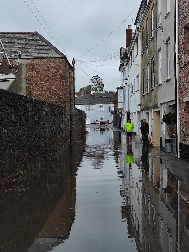
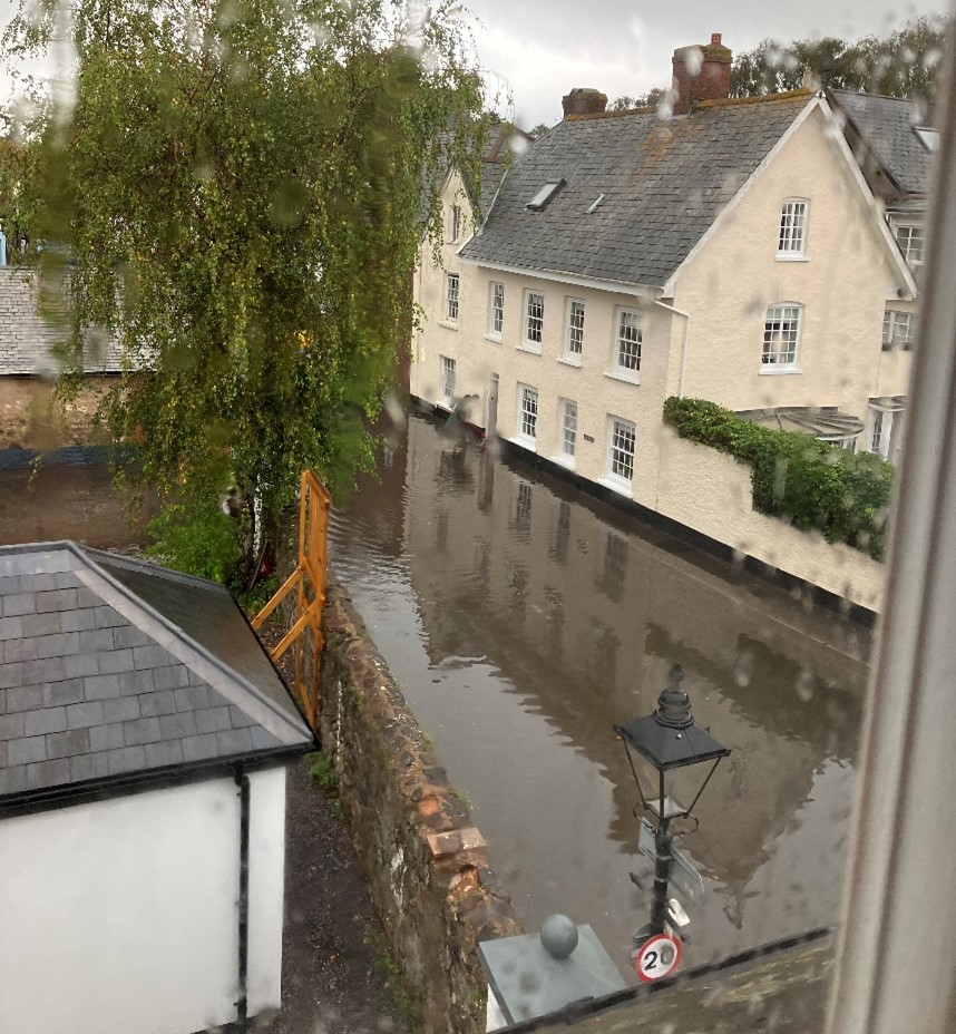
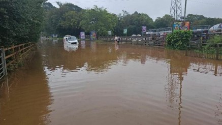
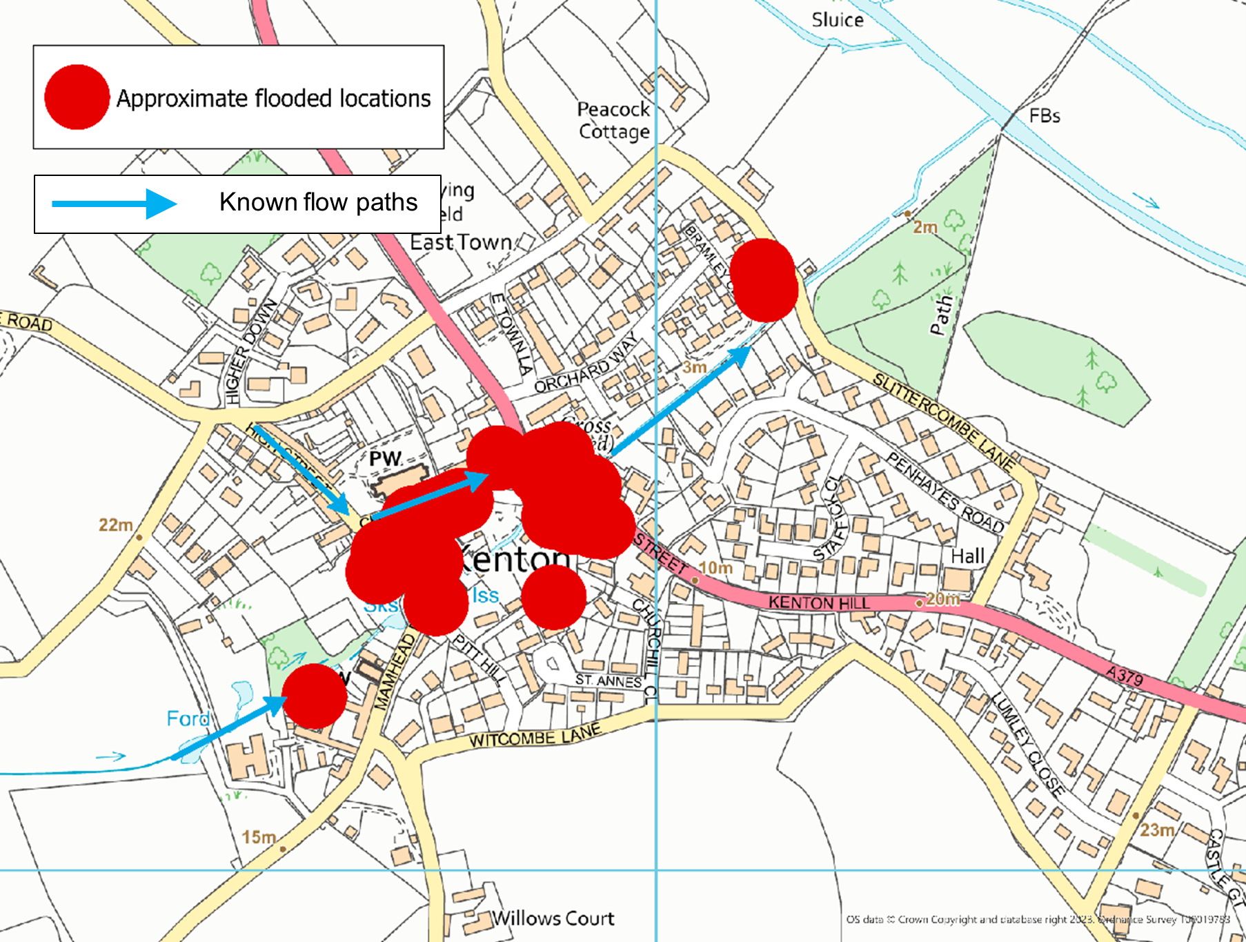
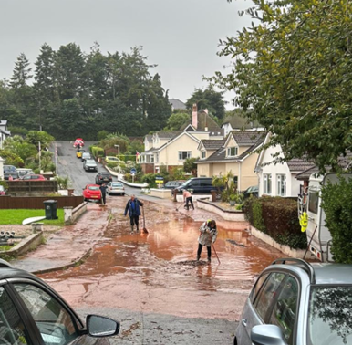
On Sunday 17th September 2023 a very intense rainfall event swept northwards and over the village of Kenton. This caused significant runoff from land in the upper catchment, overwhelming drainage systems and the local watercourse, flooding 32 properties internally to depths of up to 1m deep.
A flood flow path swept through the village causing internal flooding to properties in Mamhead Road, down Church Road and into the Triangle area. The flood water continued across Fore Street (A379) and downstream continuing to affect properties at the lower end of the village in Bramley Close.
In the wider Kenton area, downstream of the Kenton brook on the main River Kenn, a further four properties were flooded on Powderham Estate land. One property was also flooded just outside of Kenton in the Chiverstone area from surface water and a nearby ordinary watercourse.
According to residents the rainfall intensified between 13:00 and 13:30 to the point that the watercourse exceeded the capacity of the culverted section and burst its banks upstream of Mamhead Road. Overland flows were exacerbated causing large volumes of water to build up behind existing infrastructure and flood adjacent properties. At one point the force of the water became too strong, and a set of tall solid garden gates were ripped off their hinges and sent crashing into the school building on the other side of the road.
The surge of water around 13:30 flowed overland at depths of up to 1m, through the school building towards the public car park and Fore Street, collapsing a solid brick wall before re-joining the route of the watercourse downstream. The velocities in the watercourse adjacent to the public footpath down towards Slittercombe Lane continued to cause destruction in its path. River walls and gabion structures, retaining gardens and the footpath, collapsed under the strain leaving significant risks and rebuilding works for homeowners and the Parish Council.
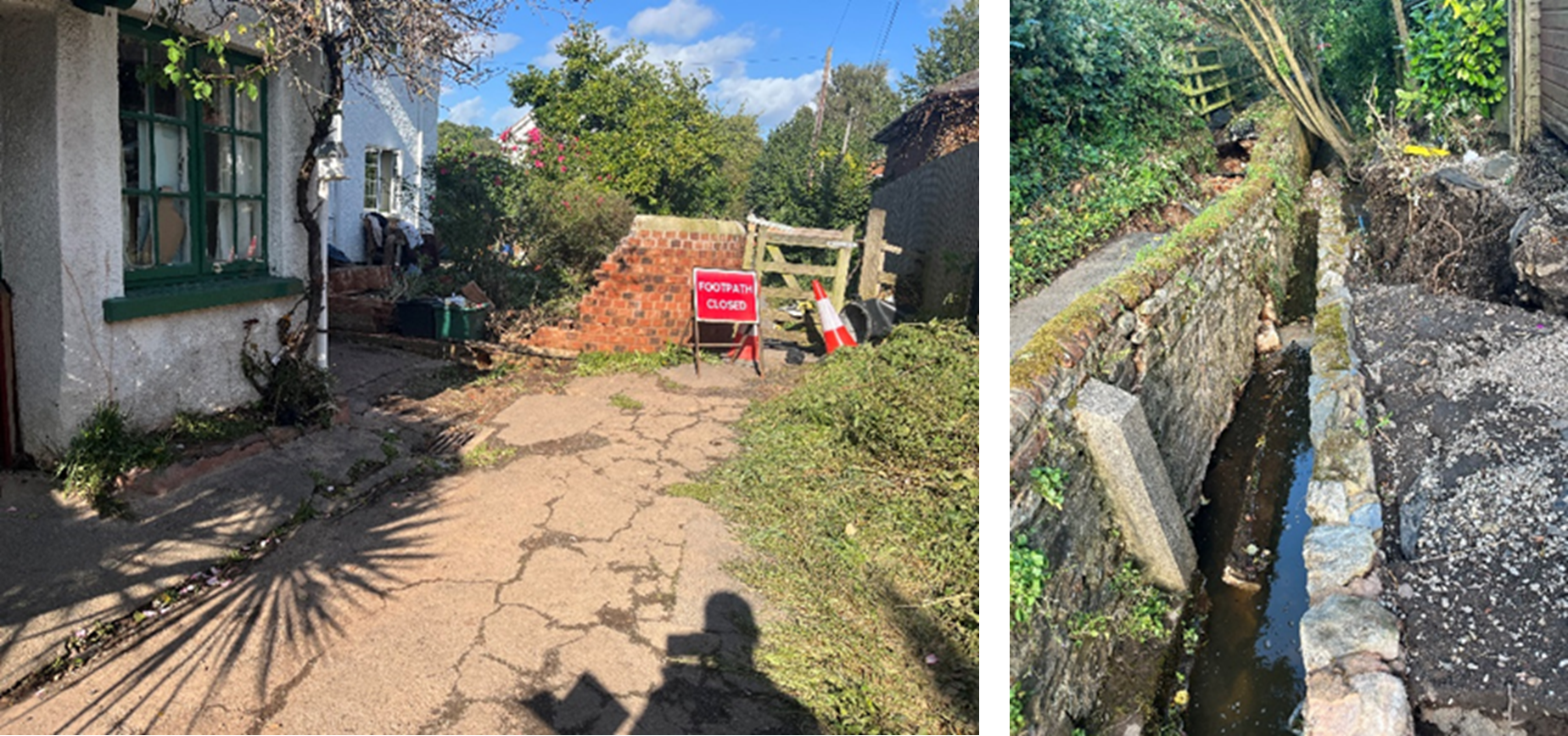
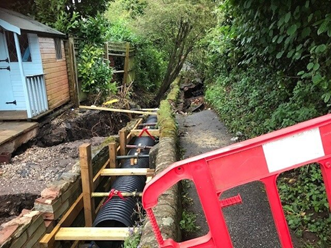
To assist the community and reduce the risk of the wall collapsing completely and blocking the channel, Devon County Council’s Flood Risk Management team arranged for temporary supports and twin pipes to be installed until such time the permanent works can be carried out by the riparian landowners. DCC also funded a one-off desilting exercise to remove the build-up in the channel and improve the efficiency of the culvert under Slittercombe Lane.
Following the event, the Environment Agency’s Land Management Team were out on site surveying the catchment. Areas were identified where land management improvements could be made to reduce surface runoff. Devon County Council continue to liaise with the Environment Agency, District and Parish Councils, local MP and the Powderham Estate, who own the surrounding land, to identify any opportunities for land management improvement and Natural Flood Management measures.
Prior to publishing this report, the culvert of the watercourse beneath Slittercombe Lane is showing signs of collapsing. An immediate road closure has been put in place and urgent works to repair or replace the culvert are being progressed by Devon County Council’s Neighbourhood Highway team with support from Flood Risk Management.
Historic Flooding
There has been previous flooding experienced in Kenton, with the following incidents recorded:
20 October 2021: Ordinary Watercourse flooding to 4 properties on Mamhead Road and the school flooded.
19 September 2014: Surface water flooding of 2 properties.
9 June 2009: Widespread surface water flooding, at least 1 property known to flood internally.
30 May 2008: 4 properties along Mamhead Road and the school flooded. Up to 12 in total affected.
22 June 2007: Local School and another property flooded from surface water runoff.
24 October 2006: Surface water flooding of 1 property.
19 October 2006: Several properties flooded from surface water runoff.
7 December 2000: 4 properties flooded.
6.3. Kennford
In Kennford, one property was reported to have flooded from surface water flows, which does not have a record of previous flooding. As Kennford has a history of flooding from the main River Kenn, Environment Agency staff visited following the flood event to assess any impact of flooding from the main river. No properties were found to have flooded from fluvial sources.
6.4 Kingsteignton
One property in Kingsteignton was affected by sewer flooding. Issues with the local sewer network have been identified by SWW and works have been scheduled to ensure the system is working efficiently and to make improvements where necessary.
6.5 Newton Abbot
In the Buckland Road and Oakland Road area, six properties were reported to have flooded from surface water and sewage. There is a history of multiple flooding from sewers at this location, believed to be generally caused by blockages in the system. SWW will be completing a hydraulic evaluation to determine capacity and increase the frequency of cleansing activities.
One commercial property was also flooded on Courtenay Street where water was reported to have come up through the floor. There is a history of internal flooding from surface water at this location.
6.6 Kingskerswell
One property was flooded in the Daccabridge Road area from surface water, due to local drainage being overwhelmed and property thresholds lower than the road level. This location is known to have flooded previously on several occasions, including in 2020.
6.7 Shaldon
One property was flooded internally in the Ringmore Road area of Shaldon, in addition to several garages in Laurel Lane. The Ringmore Brook, collects flows from the surrounding land and flows through the village, discharging into the estuary underneath Ringmore Road and the tidal defence wall. On 17th September the brook was overwhelmed, and flows came out of bank, in addition to surface water runoff on the highway, ultimately collecting on Ringmore Road. Flows were then not able to dissipate through the highway drainage and outfalls in the wall quickly enough, causing the water level to build up in the road.
It was reported that large amounts of material were washed down in the watercourse during the event, exacerbating the issues by blocking the highway drains and outfalls.
There is a history of flooding in Shaldon, predominantly from the tide, of which there is protection from the flood defence wall.
Since September 2023, Devon County Council Flood Risk Management have met with the Parish Council on site with representatives from Highways and the Environment Agency. All of the contributing factors to the flood risk in Shaldon from the multiple sources were discussed in detail and will be followed up by the relevant Risk Management Authorities in coordination with each other.
6.8 Teignmouth
One property was flooded on Bishopsteignton Road close to the hospital. Properties were also reported to have flooded in the Moor View Drive area of Teignmouth, however this could not be confirmed. There is no history of flooding in these areas.
Properties were also affected in Haytor Close from surface runoff from the surrounding fields and highway. This is a known issue and DCC Flood Risk, DCC Highways and Teignbridge District Council are liaising with local residents and landowners to try and resolve the issue.
6.9 Teignharvey
In Teignharvey, just outside of Shaldon by the River Teign Estuary, one property was flooded from surface water. There is no history of flooding at this location.
6.10 Stokeinteignhead
Three properties were flooded internally in Stokeignteignhead from surface water on the road. Works were completed earlier in the year by Devon County Council to reduce the risk to properties through Property Flood Resilience (PFR) measures. The majority of properties that had these measures installed were successfully protected and it is believed that the three properties affected on this occasion did not deploy their PFR.
There is a history of flooding in Stokeinteignhead, particularly in 2012 when the last most significant event was experienced.
Stokeinteignhead is part of the Devon Resilience Innovation Project (DRIP) which will look to increase the resilience of the village even more through natural flood management measures and attenuating flows upstream.
Following the event in September, the Environment Agency’s Land Management Team were out on site surveying the catchment. Areas were identified where land management improvements could be made to reduce surface runoff. The team will be linking in with DRIP to ensure any opportunities for improvement in the catchment are promoted.
7. South Hams Flood Incident Extent and Impact
7.1 Dartmouth
Two properties were flooded internally in Dartmouth from surface water. It was reported that the heavy rainfall led to a large amount of muddy water flowing from the watercourse between Victoria Heights and Victoria Road onto the highway. The culvert under the road was overwhelmed and obstructed by debris. These flows led to the flooding of a property on Victoria Road further down the hill. This property did not have a previous history of flooding and the residents report that up to two inches of water flooded their basement.
The second property that flooded internally from surface water is on Higher Street. four inches of water flooded the basement of the property, suggesting this was due to a blocked drain outside the basement steps.
Dartmouth also experienced highway flooding and blocked roads during the event including on Victoria Road, Castle Road, Warfleet Road, Ravensbury Drive, Charles Street and The Market area.
Dartmouth has a history of flooding with properties on Victoria Road having flooded previously, most significantly in 2004 when approximately thirteen properties on Victoria Road flooded due to surface water.
Following the event DCC has worked to ensure understanding of riparian responsibilities and better maintenance of the watercourse channel by landowners of the watercourse near Victoria Heights.
7.2 Strete
One property flooded internally from surface water in Strete. The property experienced water ingress into the basement, however there was no standing water on the highway outside the property. This property has a history of flood risk having reported flooding in May 2021.
7.3 Week
One property in Week, near Dartington, flooded internally from surface water and a nearby Ordinary Watercourse. It was reported that vegetation and debris affecting the highway drainage opposite the property caused surface water, and out of bank flows to pool in the area. The affected property had Property Flood Resilience measures installed on the front gate.
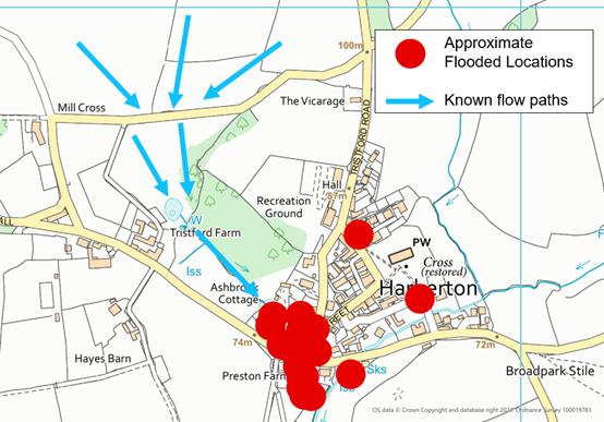
7.4 Harberton
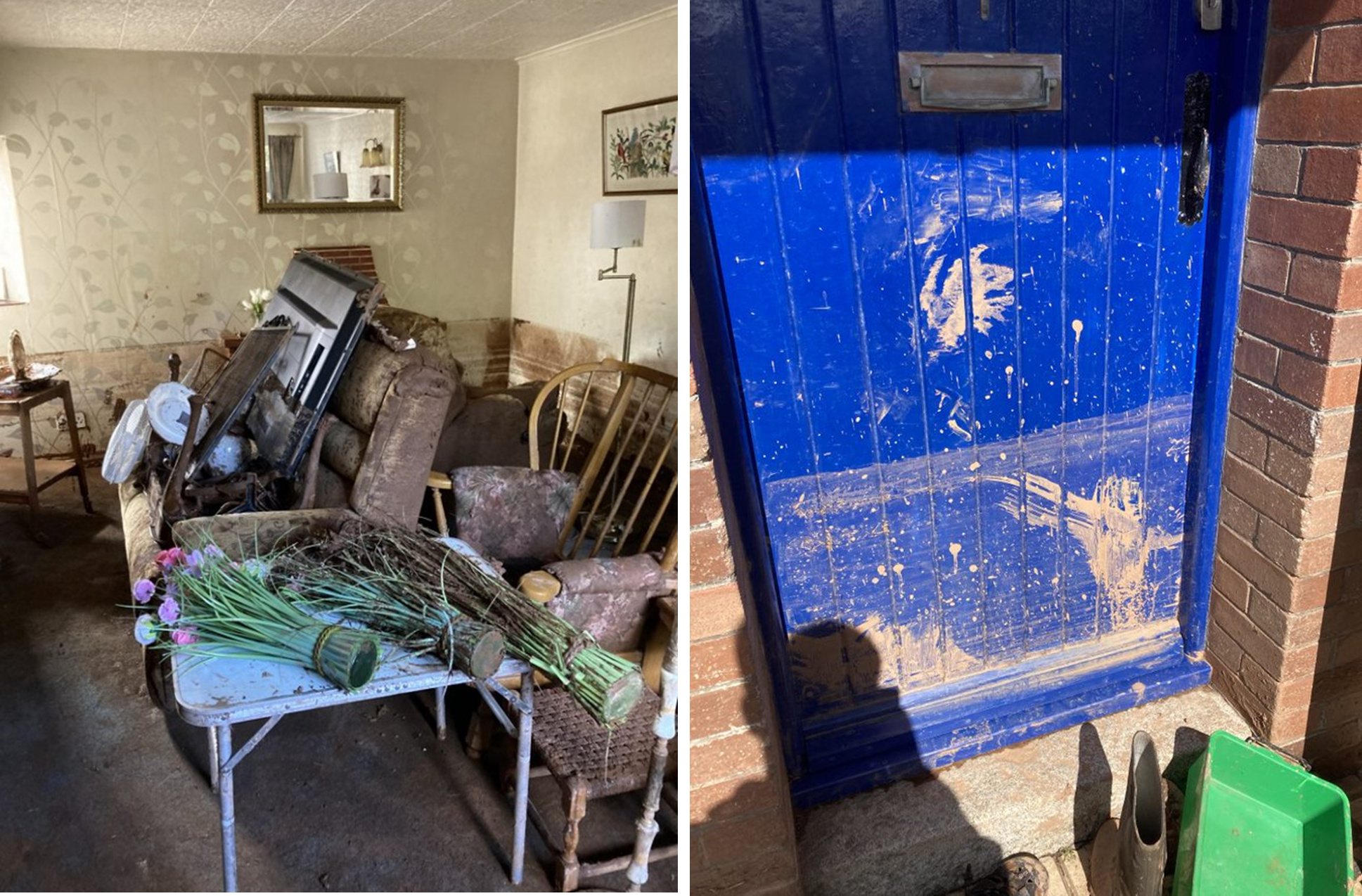
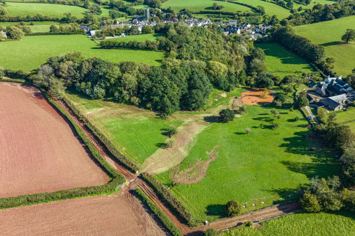
24 properties experienced internal flooding in Harberton from surface water and an ordinary watercourse, with large volumes of mud, straw and other debris being deposited throughout the village. Most of the flooded properties are to the south west of Harberton. The flooding occurred after intense rainfall with 40mm of rainfall recorded in two hours in nearby Harbertonford.. The Environment Agency’s Land Management Team are working with local landowners to identify where land management improvements could be made to reduce surface runoff.
The majority of the flood water took a path from north to south across Screw Lane, between Mill Cross and Gill’s Cross (see figure 7.1). The road here was made impassable and filled with high levels of mud. The flows crossed the orchard and entered Harberton near Ashbrook Cottage.
Village Centre
Three properties were flooded in the Town Farm area. In this location the flood waters came through the back of two properties bringing with it large volumes of mud and debris. The flows and debris overwhelmed the culvert causing out of bank flows to then continue through the village towards St Clements Terrace and Wesley Place.
Six properties were flooded on St Clements Terrace due to surface water. Muddy deposits were left in the properties and in the gardens requiring a large clean up operation from members of the community.
Three properties were flooded on St Andrew’s Cottages due to surface water. Internal depths of up to a metre were reported and an elderly woman had to be rescued from her house by the emergency services.
Three properties were flooded on Wesley Place from surface water. The water came in through the back doors of properties and left muddy deposits. Internal depths of up to half a metre were recorded.
Five properties were flooded in the Preston Barns area due to surface water. Large volumes of mud were deposited inside and outside the properties.
Two properties on Vicarage Ball were flooded. One from surface water and the other due to the ordinary watercourse which enters Harberton from the north east.
Fore Street
One property was flooded on Fore Street due to surface water. This property is isolated from the other properties affected in Harberton. Surface water entered the property from the highway, onto the front garden and then into the front door.
Vicarage Ball
One Property flooded on Vicarage Ball due to surface water entering the front of the property from the highway. Surface water reportedly pooled around the highway drain opposite the property. This property was isolated from the majority of the affected properties in Harberton.
Historic Flooding
Harberton has some history of flooding in 2000 and 2012. However, a flood scheme was built in the early 2000s which alleviated much of the flood risk to Harberton. It was not until the September 2023 event that this culvert was overwhelmed by the excessive surface runoff causing the village to experience significant flooding. One of the culvert has a screen however it was reported that this became blocked and was cleared by emergency services.
1 January 2000: 1 property flooded from ordinary watercourse
21 November 2012: 1 property flooded from surface water
7.5 Harbertonford
15 properties are reported to have flooded in Harbertonford due to the Main River and surface water. A local EA rain gauge reported 40mm of rain falling in two hours. Harberton has a history of flood risk with the previous most significant recent event in December 2020 when seven properties in the village flooded.
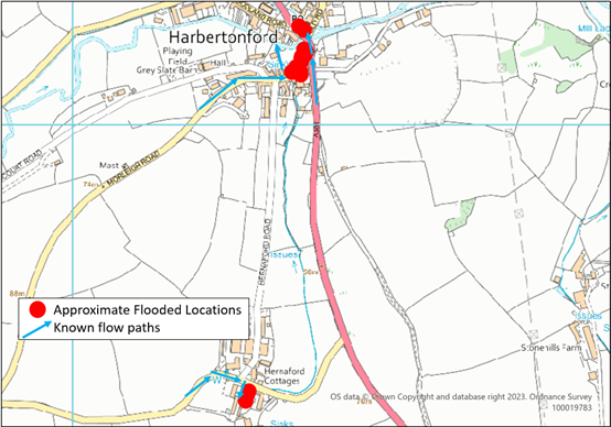
Yeolands Stream Area:
The main area affected was Moreleigh Road and the A381 where the flooding was due to the overtopping of the Main River and surface water flows. flows exceeded capacity of the Environment Agency trash screen on the culvert at Moreleigh Road. This combined with surface water from Moreleigh Road and the A381 leading to multiple properties flooding in this area.
There was reportedly no alert received from the Environment Agency alarm on the trash screen. Local residents undertook some screen clearance, however despite this clearing, the screen and culvert where overwhelmed. Once the screen overtopped the flood water flowed through the back gardens and towards Harbourne Terrace.
Two properties on Brook Villas were flooded internally due to a combination of flood water from the Main River and surface water from the A381.
Six properties on Moreleigh Road were flooded internally with internal depths reported as ranging from 0.1 metres to 0.5 metres.
Two properties flooded on the A381 on the south side of the Harbourne River flooded internally due to ingress of groundwater.
On the north side of the river two properties flooded on the A381 due to surface water.
Property Flood Resilience measures were in place on multiple properties in this area with varying levels of protection. Successful PFR measures had been installed to some by DCC, several years ago, however some that were installed privately by local residents failed under the pressure of water.
Hernaford Barns:
Three residential properties experienced flooding due to surface water. Reported depths were 0.1 metres into the dwellings. Surface water flows came from the west along the road between Hernaford Cross and the A381 and into the Hernaford.
Historic Flooding
07 Decmber 2000: 6 properties affected from surface water.
31 December 2000: At least 1 property flooded from the main river.
01 January 2003: 2 properties flooded from the main river.
03 December 2006: 1 property flooded from the main river.
07 July 2012: 12 properties flooded from the main river as reported in the Devon Summer Floods, July 2023 Section 19 report.
21 November 2012: 1 property flooded from the main river.
2 December 2013: 1 property flooded from the main river.
23 December 2012: 1 property flooded from the main river.
19 November 2016: 2 properties flooded from fluvial and surface water sources.
14 December 2020: 7 properties flooded from the main river as reported in the Harbertonford Flood Event 14th December 2020 Section 19 report.
21-24 November 2012:16 properties flooded from fluvial and surface water, as reported in the Devon Floods, November 2012 Section 19 report.
7.6 Stoke Fleming
Five properties were flooded internally in Stoke Fleming from surface water and from the ordinary watercourse. Stoke Fleming has a history of flood risk with properties in the village having reported flooding in previous years.
Church Road:
Four properties, on Church Road A379 near the junction with New Road A379, were flooded when the watercourse overwhelmed the culvert under the road. The watercourse overtopped at a location on the north side of Church Road known locally as The Shute. The water from the watercourse flooded the highway and entered the properties on either side of the road through their front doors. Surface water also reportedly contributed to the flooding, flowing from the east down the A379. The property owners and riparian owners of the watercourse have been contacted by DCC to discuss the causes of the flooding.
Venn Lane:
The fifth property which reported internal property flooding in Stoke Fleming is a property on Venn Lane which flooded due to surface water reported to have been caused by a blocked highway gully.
8. Mid Devon Flood Incident Extent and Impact
8.1 Ashill, Mid Devon
Surface water flooding was reported to five residential properties and one commercial property on the Road from Prospect House to Ashleigh House in Ashill. Flows ran northeast down the road network running clear to begin with before changing in colour assumed to be from agricultural runoff.
These flows impacted upon properties where highway drainage systems were overwhelmed, and the camber of the road/property levels led exceedance flows into property. It is believed that the 150mm diameter highway drainage system connects into a larger drainage system and then into a SWW system at the bottom of the road. This is of unknown condition, but both SWW and DCC Highways systems were anecdotally reported as unable to cope with the flows during the incident.
There was external flooding to the courtyard and garden areas of those previously affected by surface water flows down Batts Park. A highway drainage scheme installed a few years ago and some private works to introduce kerbing appeared to have helped manage flows in the September 2023 event. This appears to have reduced the risk of flooding to these properties that had all been impacted regularly between 2002 and 2012.
Historic Flooding
14 November 2002: 8+ properties reported surface water flooding from flows down Batts Park.
1 November 2005: 2 properties reported surface water flooding from flows down Batts Park.
30 October 2008: 8 properties reported surface water flooding from flows down Batts Park.
1 December 2008: Single property reported surface water flooding from flows down Batts Park.
1 November 2012: 8+ properties reported surface water flooding from flows down Batts Park.
21 November 2012: 1 property reported surface water flooding on Road from Prospect House to Ashleigh House.
19 December 2022: 1 property reported surface water flooding on Road from Prospect House to Ashleigh House.
8.2 Bampton
A single property in Castle Street reported some low-level seepage into their property from surface water attributed to blocked private and highway drainage. DCC Highways have since investigated and checked their network and informed the resident of the need to maintain their private drainage.
8.2 Blackborough
A single property at Stowford Water, Blackborough reported internal flooding from surface water/ordinary watercourse flows.
8.3 Bradninch
Three properties reported internal surface water flooding in Bradninch.
Hen Street experienced surface water flowing down the road carrying mud and stones. Water levels, whilst only a few cm deep on the road, were flowing at high velocity due to the topography, and overtopped the kerb along different points on Hen St impacting upon properties. It is unclear if the watercourse on Hen St was overtopping or having a significant impact during this event. Those with raised levels or those who could deploy informal resilience measures were able to make a positive difference to minimise internal impacts.
A single property reported external flooding on Parsonage Street with flows unable to get away into the watercourse to the south and highway drainage blocked during the event. Road flooding was reported on Cullompton Hill close to the junction of Parsonage Street and Hen Street.
A property on Hele Road reported internal flooding from surface water impacting on an integral garage and external areas experienced flooding in Charwell Meadow.
There was external flooding to gardens and driveways of properties by Hele Cross, southeast of Bradninch on the other side of the M5, from surface water runoff which is believed to have been enhanced by the poor condition of ditch networks within maize fields opposite. Landowners have been contacted by Devon County Council to address this.
Historic Flooding
21 December 2012: Surface water runoff from fields flooded a single property on Parsonage Street.
19 November 2016: Surface water flooding to a single property on Westfield.
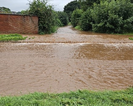
8.4 Cullompton
Cullompton experienced approximately 65mm of rainfall in 1hr 30mins leading to the internal flooding of 15 properties at Knightswood.
The affected properties experienced flooding from the Colebrook Watercourse and surface water runoff. Properties reported internal flooding to depths of 2 to 5 inches. The culvert under Colebrooke Lane overtopped onto the lane which then ran east transported by the road network in Swallow Way and Clover Drive, leading to flooding at the roundabout by Heyridge Meadow and impacting properties in Knightswood. Despite the watercourse overtopping upstream, the culverts at Heyridge Meadows were inundated suggesting that many of the structures along the Colebrook were unable to convey peak flows in the September event.
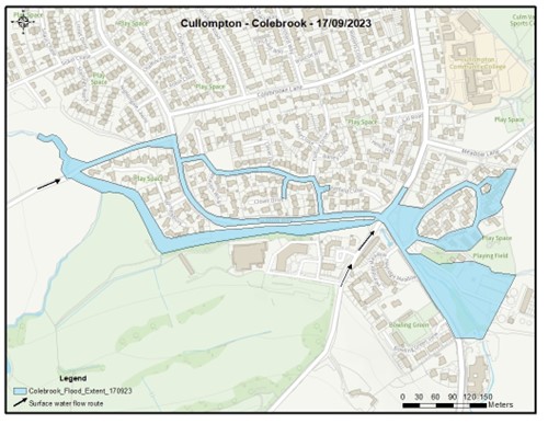
Devon County Council and the Environment Agency are proposing to progress a hydraulic model to investigate possible solutions going forward for the Colebrook.
A single property on Knowle Lane experienced surface water flooding where the property sits at a low point and flows were unable to get away into the Crow Green Stream. Following the event DCC Highways undertook clearance to form a ditch and revealed a private easement that had been overgrown.
No flooding to property was reported in relation to the Crow Green Stream itself however, the watercourse did overtop with wrack marks showing levels a few cm above the headwall adjacent to the Garage on Exeter Road. A location well known for overtopping in heavy rainfall events. Floodwaters were reported as impacting on garden areas and external outbuildings of residential properties on Crow Green and Brook Road.
Two properties on Higher Mill Lane reported near misses from surface water runoff and sewerage, where residents report a known issue with the SWW combined system led to flows backing up out of their network.
Properties in Duke St and Pound Square experienced a short period of road flooding, it is understood that some of the most at-risk properties who’d received property flood resilience from Devon County Council in 2020 were able to deploy their measures and prevent ingress.
External flooding from surface water runoff down Rull Lane and from the Millstream Gardens development was also reported with flows affecting the road network east of Willand Road, but no internal flooding was reported.
DCC flood risk team in coordination with MDDC planning have met and discussed with the development sites currently in the construction phase to ensure that all appropriate measures are in place.
Historic Flooding
17 November 1980: North Farm Estate flooded. Estimated 40 properties.
24 May 1989: 10 properties reported flooded.
7 August 1997: 30 properties reported flooded.
7 December 2000: 2 properties from surface water in Fore St.
21 to 24 November 2012: 47 properties from ordinary watercourses and main river.
19 November 2016: 2 properties from Colebrook overtopping on Colebrooke Lane.
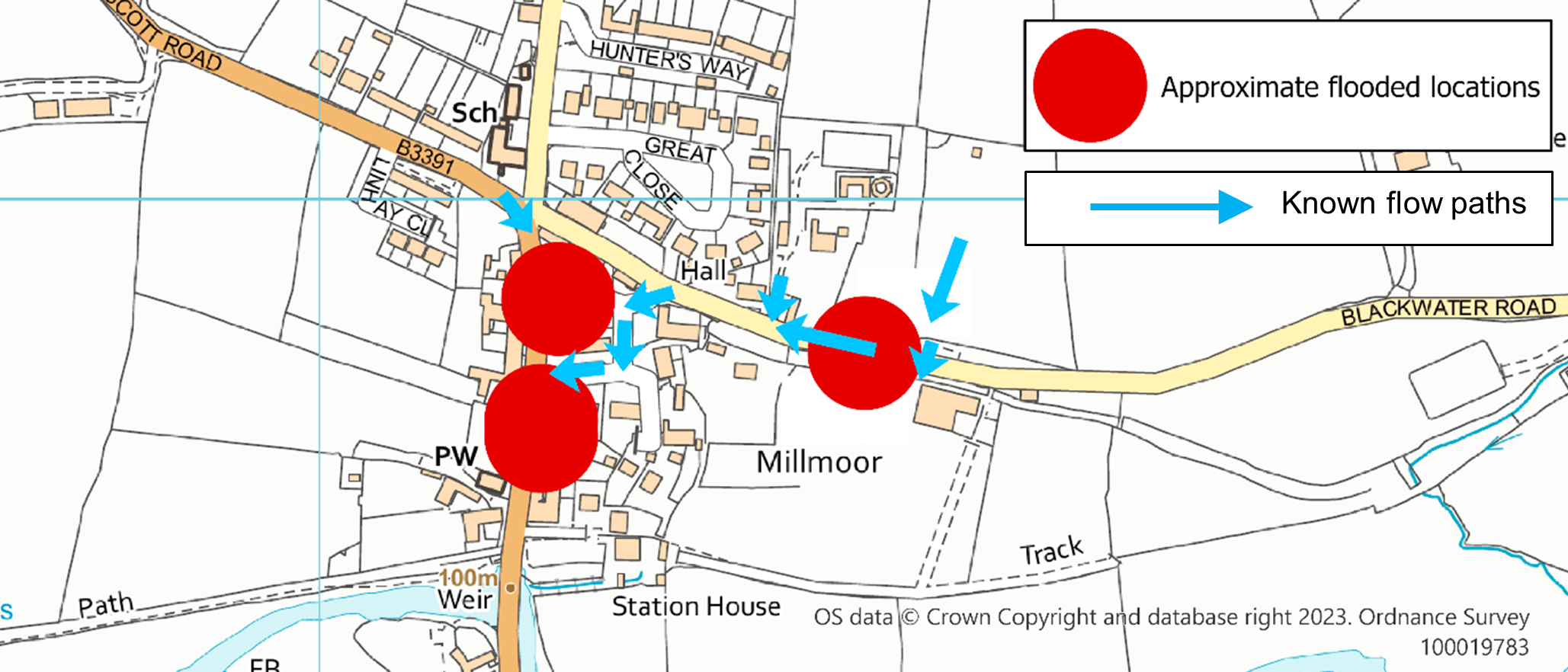
8.5 Culmstock
Six properties in Culmstock reported flooding from surface water and ordinary watercourses.
Two properties in Silver Street on the south-western edge of Culmstock reported flooding from an ordinary watercourse where the road culvert was overwhelmed and surcharged. The culvert was understood to be operational throughout the event with no reported significant blockages. Flows onto Silver Street then ran into two properties and affected the external garden area of a third property to 30cm externally. The third property had been able to undertake some groundworks in previous years to enable flows to re-enter the watercourse downstream of the culvert. The impact was in line with that modelled in the Environment Agency’s national risk of flooding from surface water maps.
Four properties in the Millmoor area, just north of the Culm itself reported surface water and ordinary watercourse flooding. The fire service attended a call received just before 3pm on 17 September 2023 with officers reporting floodwaters as knee deep on arrival. Peak floodwaters appear to have reached 30cm internally for two properties which were worst affected. It is understood that floodwaters were managed by the opening of a chamber into SWW’s network which took the pooled surface water flows away in the event.
Historic Flooding
There have been previous ordinary watercourse and surface water flooding incidents in Culmstock.
7 December 2000: A property on Silver St reported flooding from ordinary watercourse. A property in Millmoor Area reported flooding from an unknown source.
21 November 2012: 3 properties reported internal flooding due to surface water/sewer flooding.
8.6 Newton St Cyres
A single property in Smallbrook, west of Newton St Cyres reported seepage internally from surface water runoff with the primary flowpath via the A377. The highway drainage was inspected following the incident and has shown it discharges to a private network which is in poor condition.
This property has reported internal flooding previously in November 2012 and February 2014.
8.7 Sampford Peverell
External flooding to a garage in Turnpike was reported with surface water flows down Turnpike heavily silt laden with much of the material appearing to have originated from a development site upslope. As flows are then conveyed into the highway drainage system and then into the Grand Western Canal this has been attributed to pollution of the canal itself and is currently under investigation.
MDDC planning enforcement, DCC flood risk team and the Environment Agency have met with the developer to ensure that construction drainage methods are improved, this work remains ongoing as of February 2024.
8.8 Uffculme
A single property reported internal flooding along Commercial Road. This property is set below the level of the road, resulting in surface water flows from the road and footpath when the extensive highway drainage system near the property is at capacity or blocked by debris from the footpath. External and internal flooding is understood to have happened multiple times over the last 3 years.
Opportunities to minimise flows from the footpath have been considered in liaison with DCC’s public rights of way team, at this stage there does not appear to be any feasible options along the public right of way although this will remain under review. The homeowner has been encouraged to apply for DCC’s property flood resilience funding scheme.
8.9 Uplowman
The local primary school was reported to have had a single classroom internally flooded during the incident.
One residential property toward the edge of the village on Road from Springfield Farm to Lowman Cross reported internal flooding with 3 inches external and some seepage internally. Road drainage in the area was reported as silted by the resident preventing flows from getting away.
Neither of the above affected buildings in Uplowman are recorded as having flooded previously nor does national mapping suggest they are at risk from flooding.
The watercourse adjacent to Green End and Lowman Green Cottage in Uplowman overtopped into the road from Stag Mill Cross to Lowman Cross during the incident.
Surface water flooding to an external outbuilding was reported on the Road from Tower Hill past Spalsbury Farm, a couple of miles northeast of Uplowman itself.
8.10 Willand
A residential property in Willand built in the last 15 years on greenfield land reported flooding to their garage which is integral to the property. The property sits almost level with the road and is therefore, reliant on highway drainage systems always being fully operational. The fire service attended to pump floodwaters away which were a couple of inches deep.
Willand Primary School reported a flood to their boiler room due to surface water runoff.
9. West Devon Flood Incident Extent and Impact
9.1 Buckland Monachorum
Two properties flooded internally in Cuxton Meadows to a few inches deep. These properties have experienced multiple flood incidents from surface water including in May 2023 and October 2021. A private easement taking the highway surface water drainage is known to be in poor condition and it has restricted flow capacity. DCC Highways are, without prejudice, carrying out works to improve the private drainage system and also to raise kerb levels to reduce the risk of runoff being conveyed toward the front of the properties. Works are planned to be complete by the end of March 2023.
10. Recommended Actions
As a result of this investigation report, several recommendations have been made for actions to be considered in specific locations. These are either as a result of initial site or desktop investigations, or the continuation of works or investigations already in progress. DCC as the LLFA will continue to monitor and record all flood incidents that come to our attention and consider this within our action plan and future investment programme. The current action plan can be found on the DCC Flood Risk Management Website at https://www.devon.gov.uk/floodriskmanagement/. Table 10.1 below summarises the recommended actions for this flood incident.
As stated earlier in this document, the purpose of this report is to act as a tool for all of the relevant RMAs to understand and appreciate the extent of flooding in their area and to consider and prioritise those actions relevant to their authority. Due to the extent of flooding, not only from the events covered in this report, the level of recommended actions far exceeds the budgets and resources available to enable them to be delivered immediately. Although we take all flooding issues seriously it should therefore be appreciated that some actions may not be progressed within the timescales expected by some residents or communities. Every effort will be made to progress the actions if and when suitable funding is obtained.
The recommended actions highlighted in this report will be used by the LLFA to monitor progress achieved by the RMAs.
Table 10.1. Recommended actions for the affected communities in Devon.
| Action By | Recommended Action | How |
| General actions recommended for the areas featured in this report: | ||
| EA /LLFA / Local communities | Increase community resilience to all affected communities. | Where applicable assist with the development of community emergency/flood action plans. Advice and possible funding available from Devon Community Resilience Forum. |
| DCC Highways / National Highways | To ensure efficient operation of highway drains and culverts. | Review and carry out maintenance in problem areas |
| District Council / EA / LLFA | To ensure flood risk is managed from new development. | Encourage sustainable drainage practices for new developments. |
| Property Owners / LLFA / EA | Consider flood risk to own properties. | To install property level protection where necessary in liaison with appropriate Risk Management Authorities. |
| SWW | Ensure efficient operation of public combined and surface water sewers. | Continue maintenance regime and consider storm separation where appropriate. |
| In addition to the general actions the following should be considered at specific locations: | ||
| Action By | Recommended Action | How |
| EAST DEVON | ||
| Clyst St Mary | ||
| SWW | Ensure pumping station is working effectively | Carry out inspection and provide evidence of performance during flood event |
| EA | Ensure best practice land management activities in surrounding catchment | Follow up land management surveys and advise landowners |
| EA / DCC Highways / SWW / EDDC | [Current ongoing action] To better understand the current flooding situation | LLFA to coordinate further investigations in line with other priorities. |
| Dulford | ||
| DCC | Natural Flood Management downstream and upstream of A373 in Dulford | Devon Resilience Innovation Project to engage with local landowners |
| EXETER | ||
| Topsham | ||
| Topsham Flood Group with support from LLFA | Raise awareness of Topsham Flood Group and its facilities and increase support from the local community. | Promote the group locally and seek support from the Devon Community Resilience Forum for funding support and guidance. |
| SWW | Ensure pumping station is working effectively | Investigate performance of pumping station at Ferry Road, Topsham during the flood event |
| Devon Highways | Ensure efficient operation of Highway drainage system at junction of Follet Road and Ferry Road. | Already investigated and silted up gully found. Cleared on site. |
| Devon Highways | Ensure efficient operation of highway drainage up from effected properties on Monmouth Street up to Bowling Green Road | Investigate existing drainage system and ensure parked cars do not affect performance |
| SWW | Ensure efficient operation of combined sewer on Monmouth Street | Investigate performance of system and interaction with private property |
| Devon and Somerset Fire and Rescue | To consider making emergency responders aware of the impacts of bow waves when driving through flood waters. | Internal awareness campaign |
| ECC | Ensure efficient operation of garage drainage at Tappers Close | Investigate drainage system to assess performance and condition |
| LLFA | Raise awareness of the effect of bow waves on properties from passing vehicles | LLFA to liaise with Devon Community Resilience Forum to promote and engage with Devon and Somerset Fire and Rescue. |
| Central Exeter | ||
| Devon Highways/ SWW | Ensure efficient operation of highway drainage and sewer network at Cowick Street. | Partnership working to ensure any issues with the system are identified. |
| Pinhoe | ||
| DCC Highways/ LLFA/SWW | Ensure efficient operation of drainage systems | Work in partnership to identify source of flooding and ownership of drainage, sewer and watercourse network. |
| TEIGNBRIDGE | ||
| Kenton | ||
| LLFA | To identify solutions to reduce the flood risk and increase resilience. | Progress investigations and consider the development of a hydraulic model to give options going forward. |
| LLFA/EA/ Land owner | Identify opportunities for land management and natural flood management opportunities | Continue to work together to discuss options and investigate alongside any hydraulic model. |
| Parish Council | To consider options for footpath repair | Carry out repairs to collapsed wall of watercourse |
| Land / Property Owners | Carry out repairs to any damaged sections of watercourse bed, banks, walls, culverts and bridges | Private arrangements to fulfil riparian responsibilities. Appoint specialist contractors where appropriate. |
| Shaldon | ||
| LLFA/EA/ Highways | Respond to Parish Council requests for flood improvements | Investigate feasibility of improvements.
|
| SOUTH HAMS | ||
| Harberton | ||
| LLFA | To identify solutions to reduce the flood risk and increase resilience. | Progress initial study to identify next steps. |
| Highways | Ensure efficient operation of highway drainage systems | Carry out gully and drainage clearing to remove silt and mud deposited during the flood. |
| EA | To investigate surface runoff concerns and consider land management improvements | Liaise with upstream landowners and develop a plan for reducing runoff |
| Landowner | To investigate surface runoff concerns and consider land management improvements | Implement land use changes and/or alternative farming practices to reduce runoff. Consider recommendations from the EA. |
| Harbertonford | ||
| LLFA | Review performance of the installed Property Flood Resilience (PFR) measures | Liaise with PFR supplier to check installations and maintain as required. Consider any improvement requirements. |
| EA | Ensure assets are working efficiently | Review performance of the main river, debris grill and telemetry warning system |
| DCC Highways | Ensure efficient operation of highway drainage systems | Carry out gully and drainage inspection and clearance as required.
|
| MID DEVON | ||
| Ashill | ||
| DCC Highways | Ensure efficient operation of highway drainage systems | Carry out gully and drainage inspection and clearance as required. |
| SWW | Inspect and ensure efficient operation of combined sewer network | Carry out inspection and clearance as required |
| Cullompton | ||
| LLFA/EA | To review performance of the Ordinary Watercourse and Main River sections of the Colebrook | Carry out detailed assessment of flood risk and consider the production of a hydraulic model of the watercourse. |
| DCC Highways | Ensure efficient operation of highway drainage systems | Carry out inspection and clearance as required |
| WEST DEVON | ||
| Buckland Monochorum | ||
| DCC Highways | Ensure efficient operation of the highway drainage systems and review surface runoff from the highway | Maintain and where necessary clear gullies and connecting drainage. Improve/Repair existing surface water drainage systems(Works proposed). Raise kerbs to reduce runoff as appropriate (Works proposed) |
| LLFA | To consider surface water flood risk | Support DCC Highways with surface water runoff. |
| Property owners | Ensure efficient operation of private drainage systems. Protect individual properties | DCC Highways are, without prejudice, carrying out repairs to the private surface water drainage system to improve conveyance and reduce flood risk |
11. Next Steps
The next steps following this report will be for DCC as the LLFA to ensure that the recommended action tables in each chapter are presented to the responsible Risk Management Authority. DCC will consider their actions in line with other priorities and monitor delivery through regular reviews, whilst working in partnership with the EA, District Councils, SWW and the local communities affected.
There is an expectation from DCC of itself and its partners that all authorities involved will cooperate and work together to improve the flood risk in the vulnerable areas identified in this report by completing the recommended actions. As the LLFA, DCC has a responsibility to oversee the delivery of these actions.
Where minor works and quick win schemes have been identified, these will be prioritised and subject to available funding and resources will be carried out as soon as possible by the relevant authority or landowner. Any major works requiring capital investment will be considered through the EA’s Medium-Term Plan process.
A review of the actions will be carried out by DCC as the LLFA to monitor progress and encourage delivery of recommended actions.