Contents
Section 19 Flood Investigation Report
This flood investigation report has been produced by Devon County Council as a Lead Local Flood Authority under Section 19 of the Flood and Water Management Act 2010.
| Version | Undertaken by | Reviewed by | Approved by | Date |
| Draft 1 | Jago Burris | Jessica Bishop | Martin Hutchings | 18/10/2022 |
| Final | Jago Burris | Jessica Bishop | Martin Hutchings | 16/11/2022 |
1. Introduction
The Flood Risk Regulations 2009 and the Flood and Water Management Act 2010 (the Act) have established unitary and upper tier local authorities as the Lead Local Flood Authority (LLFA) for their area. This has placed a number of responsibilities on the LLFA in relation to flood risk management and in particular Section 19 of the Act which states:
Flood and Water Management Act 2010: Section 19 – Local Authorities: investigations
- On becoming aware of a flood in its area, a lead local flood authority must, to the extent that it considers it necessary or appropriate, investigate –
- which risk management authorities have relevant flood risk management functions, and
- whether each of those risk management authorities has exercised, or is proposing to exercise, those functions in response to the flood.
- Where an authority carries out an investigation under subsection (1) it must –
- publish the results of its investigation, and
- notify any relevant risk management authorities.
Flood and Water Management Act (2010), S.19, c.29, London: HMSO
A ‘Risk Management Authority’ (RMA) means:
(a) the Environment Agency (EA),
(b) a lead local flood authority,
(c) a district council for an area for which there is no unitary authority,
(d) an internal drainage board,
(e) a water company, and
(f) a highway authority.
When considering if it is necessary or appropriate to investigate a flood event Devon County Council (DCC) will review the severity of the incident, the number of properties affected and the frequency of such an occurrence. Devon’s Local Flood Risk Management Strategy clearly sets out the criteria to be used when considering a Flood Investigation Report.
Although not all of the locations in this report meet the significance threshold of 5 or more properties flooded, to ensure that the full extent of the flooding is appreciated and recorded it has been decided to include all locations brought to our attention which experienced any internal property flooding, and also other areas of particular concern.
In partnership with the other RMAs in Devon this report has been produced to comply with legislation and to determine the main causes of the flooding. It should be noted that in order to progress with their flood risk management function DCC has opted to develop this report further by considering the various actions that should be considered by the relevant RMA. DCC as the LLFA will continue to monitor the list of actions with all of the RMAs and will assist in the delivery where practical to do so.
The area investigated within this report will have a number of recommended actions to be taken forward by the relevant RMAs or in some cases, by the landowner or local community action group. There are various levels of action that can be taken depending on the severity of the situation and the practical solutions available to reduce the risk of further flooding. The recommended actions will generally fall into one of the following categories:
Delivery of Quick win schemes: a solution that can be implemented quickly by the Risk Management Authorities or Local Authority at relatively low cost; some of these have already been completed as this report has been progressed.
Further investigation/research: Further investigations such as catchment studies and hydrological/hydraulic assessments to understand the flow rates and directional paths and evaluate the extent of flooding. These would provide evidence for future capital investment.
Development of Future schemes: Where immediate action is not financially viable or a solution not readily available then a larger scale flood alleviation scheme may be required. In such cases national funding would need to be secured together with additional contributions from others, such as local levy, local authorities and other third parties.
Landowner action: Members of the public who own land adjacent to watercourses have riparian responsibilities and therefore have a duty to maintain their section of watercourse to ensure there is no impediment of flow. Other works to protect their property may also need to be funded by themselves to ensure delivery within their timescales.
Community action: In some cases, it may be prudent for community groups to join forces and deliver and maintain their own local schemes. This may generate further contributions from local levy or the LLFA.
This investigation report will provide a starting point, with suggested actions being further refined in the light of further studies and where possible, through further dialog with the affected communities.
Recommended Actions:
The purpose of this report is to act as a tool for all of the relevant RMAs to understand and appreciate the extent of flooding in their area and to consider and prioritise those actions relevant to their authority. Due to the extent of flooding, not only from the event covered in this report, the level of recommended actions far exceeds the budgets and resources available to enable them to be delivered immediately. Although we take all flooding issues seriously it should therefore be appreciated that some actions may not be progressed within the timescales expected by some residents or communities. Every effort will be made to progress the actions if and when suitable funding is obtained.
The recommended actions highlighted in this report will be used by the LLFA to monitor progress achieved by the RMAs.
2. Risk Management Authority Responsibilities
2.1 Recording Flood Incidents
LLFAs must record flood incidents as part of their duties under the Flood and Water Management Act. The information below shows the national guidance given as part of the Preliminary Flood Risk Assessment Spreadsheet submission to the EA, which outlines information to be collected by LLFAs.
Information the LLFA must record
- Devon County Council (DCC) will record this on the DCC flood incident database:
- Start Date
- Duration of event i.e., days
- Probability
- Main source: Surface water runoff; Groundwater; Ordinary watercourses; Artificial infrastructure; Main rivers; The sea; No data
- Main mechanism: Natural exceedance; Defence exceedance; Failure; Blockage or restriction; or No data
- Main characteristics: Natural flood; Flash flood; Deep flood; Snow melt flood; No data
- Significant consequences:
- To human health (residential properties)
- To economy (non-residential properties)
- To the environment (designated sites flooded)
2.2 Key Responsibilities
RMAs in Devon all have their own roles and responsibilities. The general RMA responsibilities in relation to flood risk and surface water management are outlined below:
The Environment Agency is responsible for managing the risk from the sea, Main Rivers and reservoirs and has a strategic overview role for all flood risk management, making it a key local partner for DCC, especially when managing the risk from combined sources and in the event of a large flood incident. The EA also provides a flood warning service throughout England and Wales in areas at risk of flooding from rivers or the sea.
Devon County Council as the Lead Local Flood Authority is responsible for overseeing the flood risk from Ordinary Watercourses, groundwater and surface water runoff. They are also responsible for consenting to works on Ordinary Watercourses and enforcing the removal of any unlawful structure or obstruction within the watercourse. And, as previously stated they must ensure that a flooding investigation is carried out by the relevant authority and publish a report. DCC must also prepare a Local Flood Risk Management Strategy and maintain a register of flood risk assets.
Local District Councils are classified as land drainage authorities with discretionary powers under the Land Drainage Act, such as the implementation and maintenance of flood defences on ordinary watercourses. They also have powers under the Public Health Act to ensure the removal of any blockage within an Ordinary Watercourse that is considered a nuisance. As a planning authority they are responsible for the preparation of development plans and making decisions based on planning policy.
Devon County Council as the Highway Authority maintains the highway drainage system to reduce the amount of standing water on the highway. This is achieved by limiting the water on the roads and ensuring that they are kept clear of rainwater, including the maintenance of highway gullies and culverts.
National Highways is responsible for managing, maintaining, and improving the Motorway and trunk roads across England and any associated drainage and flood risk.
Land/Property Owners that have a watercourse in or adjacent to their land have riparian responsibilities on that watercourse. This means the landowner must:
- Let water flow through their land without any obstruction, pollution or diversion which affects the rights of others.
- Accept flood flows through their land, even if these are caused by inadequate capacity downstream.
- Keep the banks clear of anything that could cause an obstruction and increase flood risk, either on their land or downstream if it is washed away.
- Maintain the bed and banks of the watercourse and the trees and shrubs growing on the banks and should also clear any litter or debris from the channel and banks, even if it did not come from their land.
- Keep any structures, such as culverts, trash screens and debris grills, weirs and mill gates, clear of debris.
The LLFA must also take an overseeing role to ensure that all flood risk is being managed appropriately.
In small, localised groundwater and surface water flooding incidents which do not reach the threshold level to trigger a flood investigation by the LLFA under Section 19, the Local Authorities will work in partnership to consider the appropriate action.
All RMAs have a duty to co-operate and to share information in relation to their flood risk management functions.
3. Flood Incident Summary
3.1 Incident Summary
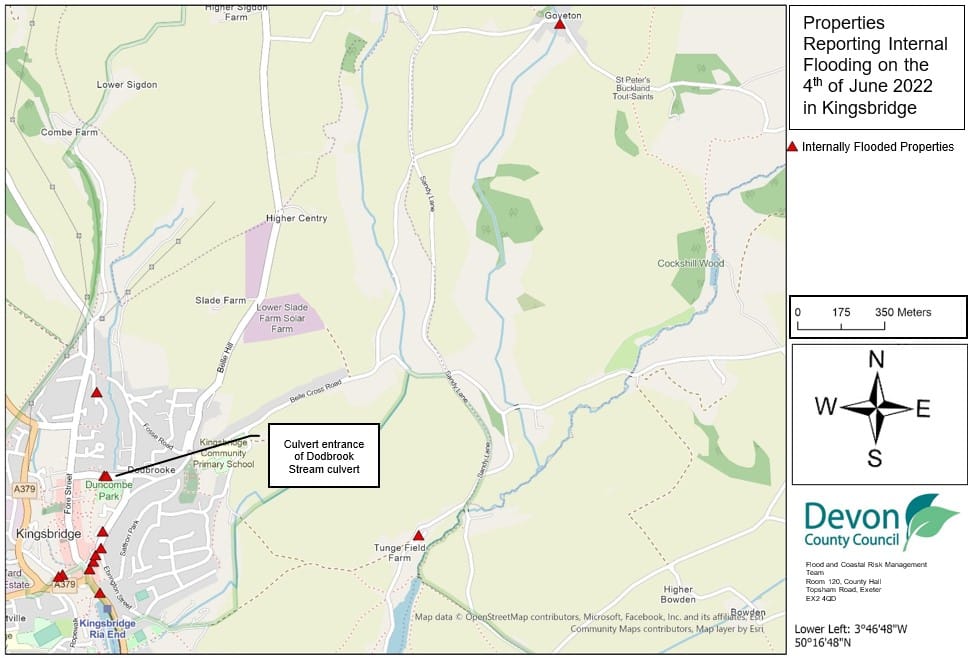
On the morning of the 4th of June 2022, heavy rain led to internal property flooding occurring in the Kingsbridge area. Kingsbridge is a town in the South Hams district at the head of the Kingsbridge Estuary. The worst affected location was in the Bridge Street area, with internal property flooding also occurring on Duncombe Street, Mill Street, Church Street, and Manor Park. In the outskirts of Kingsbridge, one property experienced flooding on Embankment Road and one property in Goveton. In total thirteen properties were reported to have experienced internal property flooding.
Table 3.1 lists the areas and streets affected by flooding, and the corresponding number of properties reported to have flooded in each location. It should be noted that the flooded locations have been reported alphabetically and not in any order of priority. Table 3.2 lists the depth of rainfall recorded from the Environment Agency automatic rainfall gauge that is located closest to the affected areas. Table 3.2 shows rainfall data collected from the Davey Park Farm gauge, south-west of Kingsbridge.
During the rainfall event on the morning of the 4th of June it has been reported that the Dodbrook Stream did not burst its banks and the flooding was due to localised surface water rather than water flowing down the Dodbrook Stream from further up the catchment. It has also been reported that the pond between Wallingford Road and Stentiford Hill did not overflow as has happened in past events. The intensity of the rainfall exceeded the capacity and ability to enter the drainage system causing it to be overwhelmed and flooding to occur. Once the storm abated the system was able to catch up and the flood waters receded.
Representatives from the Town Council have suggested that residential development sites could have contributed to the flooding. Excess water is reported to have come from a development on Scholars Walk which uses attenuation tanks. Water and mud are reported to have come out of a development to the east of Stentiford Hill during the rainfall event on the 4th June. Highway drains are also reported to have been blocked in the area around the Applegate Park site.
Multiple residents of Kingsbridge affected by the flooding have reported that highway drains were overwhelmed including those on Church Street, Bridge Street, and Duncombe Street. They reported that muddy water overwhelmed the drains and then entered their properties and businesses.
Table 3.1 List of localised areas in Kingsbridge affected
| Location | Number of properties flooded | Source of flooding |
| Bowcombe Road | 1 | Surface Water |
| Duncombe Street | 2 | Surface Water |
| Goveton | 1 | Surface Water |
| Manor Park | 1 | Surface Water |
| Mill Street/ Bridge Street/ Church Street/ The Quay | 8 | Surface Water |
| Total properties flooded: 13 | ||
Table 3.2: Rainfall (mm) recorded at Davey Park Farm on 4th June 2022.
| Time | Rainfall (mm) |
| 04/06/2022 08:15 | 0.4 |
| 04/06/2022 08:30 | 1.1 |
| 04/06/2022 08:45 | 1 |
| 04/06/2022 09:00 | 1.2 |
| 04/06/2022 09:15 | 1.5 |
| 04/06/2022 09:30 | 5.3 |
| 04/06/2022 09:45 | 3.5 |
| 04/06/2022 10:00 | 1.2 |
| 04/06/2022 10:15 | 3.3 |
| 04/06/2022 10:30 | 1.4 |
| 04/06/2022 10:45 | 0.4 |
| 04/06/2022 11:00 | 0.1 |
3.2 Historic Flooding
There has been previous flooding experienced in Kingsbridge. The most notable incidences recorded can be seen in Table 3.2.
Table 3.3 Historic flooding events in Kingsbridge
| 09/02/2009 | 16 properties suffered from flooding across Kingsbridge |
| 09/03/2009 | 8 properties suffered from flooding in the Duncombe Street area |
| 22/06/2012 | 5 properties suffered from flooding in the Bridge and Mill Street areas |
| 07/07/2012 | 3 properties suffered from flooding in the Bridge Street area |
| 22/12/2012 | 28 properties suffered from flooding across Kingsbridge |
| 05/02/2014 | 6 properties suffered from flooding in the Mill Street area |
| 14/02/2014 | 7 properties suffered from flooding in Mill Street and Lower Union Road area. |
| 20/10/2021 | 2 properties suffered from flooding in the Mill Street area |
3.3 Data and Information Collation
It should be noted that this report is only based on the information brought to the attention of DCC through its professional partners, the media, the public and where further investigation by the authorities have identified additional flooded properties. Therefore, it cannot be guaranteed to contain an exact or exhaustive list of individual properties or affected communities in the June 4th 2022 event.
4. Extent and Impact of Flooding
4.1 Kingsbridge
4.1.1 Mill Street, Bridge Street, Church Street and The Quay
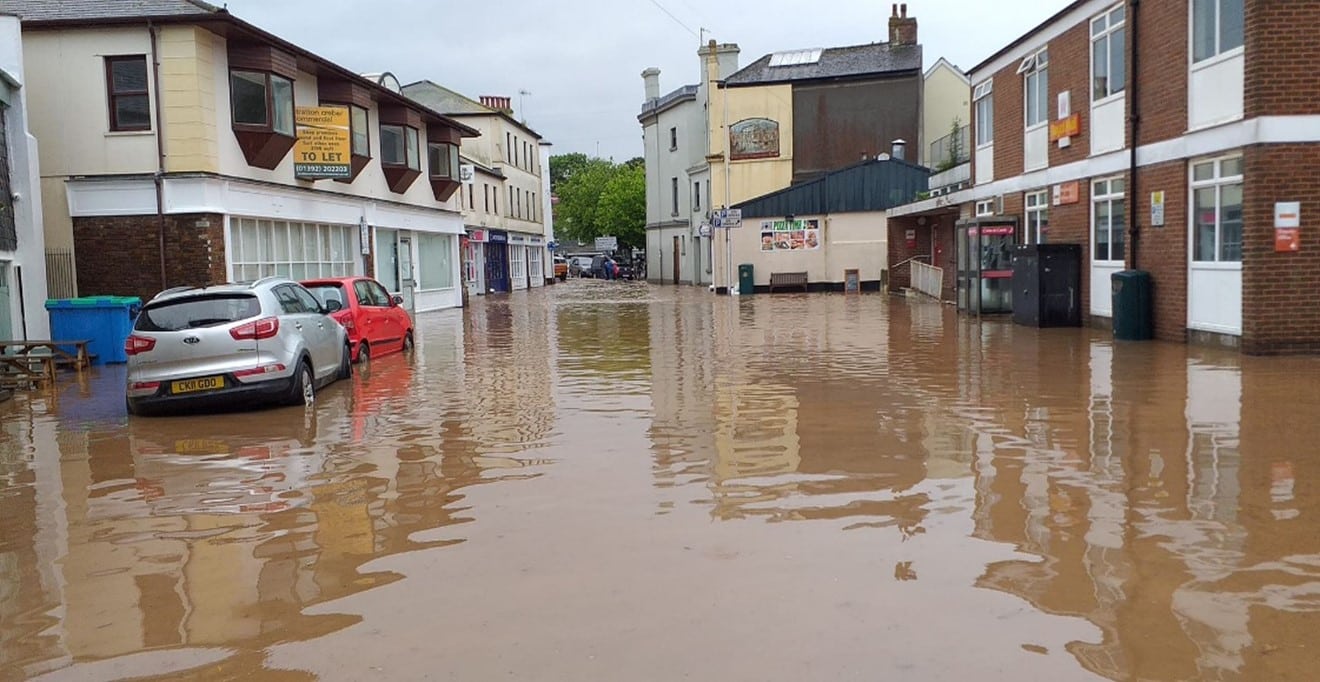
The area around Bridge Street and central Kingsbridge experienced the majority of the flooding on the 4th June 2022. Surface water from the heavy rainfall overwhelmed the highway drains and flooded into properties. The photo in Figure 4.1 shows the depth of the flooding against the buildings and cars on the street. The ongoing Kingsbridge Integrated Urban Drainage Model (IUDM) and Flood Analysis report by Pell Frischmann shows that the primary flood risk on Church Street is fluvial and exacerbated by surface water when the watercourse cannot accept additional flows. The town centre is a complex area in terms of flood risk and the IUDM report has confirmed that there is fluvial flood risk as well as surface water flood risk from the combined system. With the additional factor of tide locking in this area the drainage system is inadequate to cope with a 1 in 10-year return storm event.
Figure 4.1 Flooding on bridge Street on 4th June 2022
4.1.2 Bowcombe Road
One property was flooded on Bowcombe Road. A resident reported that the drains blocked at the top of the lane and water brought debris down the road. This debris blocked the nearby drain which then caused water to enter the property.
4.1.3 Manor Park
Water entered the garage of a property on Manor Park to the depth of around 150mm. The resident reported that the dropped kerb at the top of their drive allowed water to flow from the road into their property. This was the only area that flooded on the 4th June 2022 which was not predicted to be at risk by the IUDM hydraulic modelling.
4.1.4 Duncombe Street
Two properties are reported to have flooded on Duncombe Street. Blocked drains on the road are reported to have contributed to this. The Kingsbridge IUDM report states that the primary flood risk in this area is fluvial which can be exacerbated by surface water. The report also identifies that the culvert is incapable of taking sufficient flows in flood events which corroborates the experience of the residents on the 4th June 2022.
4.1.5 Cookworthy Road
No properties were reported to have flooded on Cookworthy Road; however, surface water was flowing down the steps by Tesco and into the car park creating a potentially hazardous situation for shoppers. The IUDM report states that the storage and culvert in the Tesco area is insufficient, and the car park slopes towards the store entrance.
4.2 Highway Infrastructure
During this event, surface water flooding affected the Highway network in Kingsbridge. Bridge Street was flooded by surface water and became unsafe for traffic to pass. Highway drains on Church Street, Bridge Street, and Duncombe Street were overwhelmed due to the intensity of the storm event, contributing to the flooding.
4.3 Sewerage Infrastructure
The sewer network and its integration with other local drainage and flooding mechanisms in Kingsbridge has been the subject of an IUDM study, commissioned by South West Water, Devon County Council and the Environment Agency:
The foul sewer network serves both the town of Kingsbridge and the village of Churchstow, with the sewage treatment works located to the south of Kingsbridge on the west side of the estuary. As is to be expected from a town whose development dates back to the 19th Century and earlier, the main trunk sewer network is predominately combined (both foul and surface water), with separate foul and surface water systems being restricted to newer developments on the periphery of the town.
The areas that experienced flooding on the 4th June, were predicted by the hydraulic model, except for Manor Park which suffered flooding from pluvial runoff. Though the flooding occurred after high tide the surface water system would still have had a reduced discharge flow for at least 1 – 2 hours after high tide. This would have hampered the draining of the catchment and possibly caused discharges from the combined sewer overflows at Bridge Street and the bus station.
4.4 Planning and development
Concerns have been raised regarding the impact of ongoing development sites on the flood risk in Kingsbridge, particularly in the 4th June event, with muddy and silty flood waters being conveyed in the town.
Developers have a responsibility to ensure a robust drainage strategy is in place during the construction phase in addition to once the development is complete. Breach of any planning conditions will be for the Local Planning Authority, South Hams District Council enforcement to take any necessary action.
All Risk Management Authorities in Devon should encourage the use of Sustainable Drainage Systems and promote the benefits, such as improving water quality, biodiversity and amenity, channelled throughout various groups, development management and through advice on Local Authority Core Strategies, development plans and policies. Devon County Council will give guidance to Planning Authorities and the development industry as a Statutory Consultee, fulfilling a duty to check and approve sustainable drainage system designs for major developments.
5.0 Recommended Actions
The following actions in Table 5.1 are recommended for the areas affected in this chapter.
| Action By | Recommended Action | How |
| DCC LLFA / SWW / EA | Progress flood improvements as recommended in the finalised Kingsbridge IUDM study | Work in partnership to finalise the report and hydraulic model to inform options and business case to develop a potential scheme for preferred option, subject to funding justification. |
| DCC LLFA / SWW / EA | Increase community resilience | To consider Property Flood Resilience (PFR) measures where necessary as part of a wider multi-stage solution through the IUDM report preferred option |
| DCC LLFA / SWW / EA | Increase community resilience | To consider natural flood management options within the catchment as part of a wider multi-stage solution through the IUDM report preferred option |
| Kingsbridge Town Council | Increase community resilience | Ensure Community Emergency Plan is up to date. Support available from DCC, Environment Agency and Devon Community Resilience Forum. |
| SWW | Ensure efficient operation of public combined and surface water sewers. | Continue maintenance regime and consider future investment in Kingsbridge sewer network improvements, such as storm water separation where appropriate. |
| DCC Highways | To ensure efficient operation of highway drains and culverts. | Review and carry out any maintenance as required.
Investigate feasibility of installing ‘smart gullies’ in partnership with Devon Resilience Innovation Project |
| South Hams District Council | Ensure flood risk is managed from developments in construction phase and planning conditions are being adhered to | Investigate current developments in Kingsbridge area and take appropriate enforcement action if necessary |
| EA | Ensure efficient operation of Dodbrook Stream culvert | Carry out maintenance or enforcement action as necessary |
| Land owners | Ensure efficient operation of ordinary watercourses though their land | Carry out maintenance responsibilities to ensure a free flow of water |
| South Hams District Council / EA / DCC LLFA | To ensure flood risk is managed from new developments. | Encourage sustainable drainage practices for new developments. |
6. Next Steps
The next steps following this report will be for DCC as the LLFA to ensure that the recommended action tables in each chapter are presented to the responsible Risk Management Authority. The DCC LLFA will consider their actions in line with other priorities and monitor delivery through regular reviews, whilst working in partnership with DCC Highways, the EA, District Councils, South West Water and the local communities affected.
There is an expectation from DCC of itself and its partners that all authorities involved will cooperate and work together to improve the flood risk in the vulnerable areas identified in this report by completing the recommended actions. As the LLFA, DCC has a responsibility to oversee the delivery of these actions.
Where minor works and quick-win schemes have been identified, these will be prioritised and will be carried out as soon as possible by the relevant authority or landowner, subject to available funding and resources. Any major works requiring capital investment will be considered through the EA’s Medium-Term Plan process.
A review of the actions will be carried out by DCC as the LLFA in order to monitor progress and encourage delivery of recommended actions.