Contents
Report preparation
This flood investigation report has been produced by Devon County Council as a Lead Local Flood Authority under Section 19 of the Flood and Water Management Act 2010
1. Introduction
The Flood Risk Regulations 2009 and the Flood and Water Management Act 2010 (the Act) have established unitary and upper tier local authorities as the Lead Local Flood Authority (LLFA) for their area. This has placed a number of responsibilities on the LLFA in relation to flood risk management and in particular Section 19 of the Act which states:
Flood and Water Management Act 2010: Section 19 – Local Authorities: investigations
- On becoming aware of a flood in its area, a lead local flood authority must, to the extent that it considers it necessary or appropriate, investigate –
- which risk management authorities have relevant flood risk management functions, and
- whether each of those risk management authorities has exercised, or is proposing to exercise, those functions in response to the flood.
- Where an authority carries out an investigation under subsection (1) it must –
- publish the results of its investigation, and
- notify any relevant risk management authorities.
Flood and Water Management Act (2010), S.19, c.29, London: HMSO
A ‘Risk Management Authority’ (RMA) means:
- the Environment Agency (EA),
- a lead local flood authority,
- a district council for an area for which there is no unitary authority,
- an internal drainage board,
- a water company, and
- a highway authority.
When considering if it is necessary or appropriate to investigate a flood event Devon County Council (DCC) will review the severity of the incident, the number of properties affected and the frequency of such an occurrence. Devon’s Local Flood Risk Management Strategy clearly sets out the criteria to be used when considering a Flood Investigation Report.
Although not all of the locations in this report meet the significance threshold of 5 or more properties flooded, to ensure that the full extent of the flooding is appreciated and recorded it has been decided to include all locations brought to our attention which experienced any internal property flooding, and also other areas of particular concern.
In partnership with the other RMAs in Devon this report has been produced to comply with legislation and to determine the main causes of the flooding. It should be noted that in order to progress with their flood risk management function DCC has opted to develop this report further by considering the various actions that should be considered by the relevant RMA. DCC as the LLFA will continue to monitor the list of actions with all of the RMAs and will assist in the delivery where practical to do so.
Each affected area or group of smaller areas investigated within this report will have a number of recommended actions to be taken forward by the relevant RMAs or in some cases, by the land owner or local community action group. There are various levels of action that can be taken depending on the severity of the situation and the practical solutions available to reduce the risk of further flooding. The recommended actions will generally fall into one of the following categories:
Delivery of Quick win schemes:
A solution that can be implemented quickly by the Risk Management Authorities or Local Authority at relatively low cost; some of these have already been completed as this report has been progressed.
Further investigation/research:
Further investigations such as catchment studies and hydrological/hydraulic assessments to understand the flow rates and directional paths and evaluate the extent of flooding. These would provide evidence for future capital investment.
Development of Future schemes:
Where immediate action is not financially viable or a solution not readily available then a larger scale flood alleviation scheme may be required. In such cases national funding would need to be secured together with additional contributions from others, such as local levy, local authorities and other third parties.
Land owner action:
Members of the public who own land adjacent to watercourses have riparian responsibilities and therefore have a duty to maintain their section of watercourse to ensure there is no impediment of flow. Other works to protect their property may also need to be funded by themselves to ensure delivery within their timescales.
Community action:
In some cases it may be prudent for community groups to join forces and deliver and maintain their own local schemes. In some cases this may generate further contributions from local levy or the LLFA.
This investigation report will provide a starting point, with suggested actions being further refined in the light of further studies and where possible, through further dialog with the affected communities.
Recommended Actions:
The purpose of this report is to act as a tool for all of the relevant RMAs to understand and appreciate the extent of flooding in their area and to consider and prioritise those actions relevant to their authority. Due to the extent of flooding, not only from the events covered in this report, the level of recommended actions far exceeds the budgets and resources available to enable them to be delivered immediately. Although we take all flooding issues seriously it should therefore be appreciated that some actions may not be progressed within the timescales expected by some residents or communities. Every effort will be made to progress the actions if and when suitable funding is obtained.
The recommended actions highlighted in this report will be used by the LLFA to monitor progress achieved by the RMAs.
2. Risk Management Authority Responsibilities
2.1 Recording Flood Incidents
LLFAs must now record flood incidents as part of their new duties. The information below shows the national guidance given as part of the Preliminary Flood Risk Assessment Spreadsheet submission to the EA, which outlines information to be collected by LLFAs.
Information the LLFA must now record
LLFAs should record the following information from December 2011’ Devon County Council (DCC) will record this on the DCC flood incident database:
- Start Date
- Days duration
- Probability
- Main source: Surface water runoff; Groundwater; Ordinary watercourses; Artificial infrastructure; Main rivers; The sea; No data
- Main mechanism: Natural exceedance; Defence exceedance; Failure; Blockage or restriction; or No data
- Main characteristics: Natural flood; Flash flood; Deep flood; Snow melt flood; No data
- Significant consequences:
- To human health (residential properties)
- To economy (non residential properties)
- To the environment (designated sites flooded)
2.2 Key Responsibilities
RMAs in Devon all have their own roles and responsibilities. The general RMA responsibilities in relation to flood risk and surface water management are outlined below:
The Environment Agency
The Environment Agency is responsible for managing the risk from the sea, Main Rivers and reservoirs and has a strategic overview role for all flood risk management, making it a key local partner for DCC, especially when managing the risk from combined sources and in the event of a large flood incident. The EA also provides a flood warning service throughout England and Wales in areas at risk of flooding from rivers or the sea.
Devon County Council as the Lead Local Flood Authority
Devon County Council as the Lead Local Flood Authority is responsible for overseeing the flood risk from Ordinary Watercourses, groundwater and surface water runoff. They are also responsible for consenting to works on Ordinary Watercourses and enforcing the removal of any unlawful structure or obstruction within the watercourse. And, as previously stated they must ensure that a flooding investigation is carried out by the relevant authority and publish a report. DCC must also prepare a Local Flood Risk Management Strategy and maintain a register of flood risk assets.
Local District Councils
Local District Councils are classified as land drainage authorities with discretionary powers under the Land Drainage Act, such as the implementation and maintenance of flood defences on ordinary watercourses. They also have powers under the Public Health Act to ensure the removal of any blockage within an Ordinary watercourse that is considered a nuisance. As a planning authority they are responsible for the preparation of development plans and making decisions based on planning policy.
Devon County Council as the Highway Authority
Devon County Council as the Highway Authority maintains the highway drainage system to reduce the amount of standing water on the highway. This is achieved by limiting the water on the roads and ensuring that they are kept clear of rainwater; including the maintenance of highway gullies and culverts.
The Highways Agency
The Highways Agency is responsible for managing, maintaining and improving the Motorway and trunk roads across England and any associated drainage and flood risk.
Land/Property Owners
Land/Property Owners that have a watercourse in or adjacent to their land have riparian responsibilities on that watercourse. This means the landowner must:
- Let water flow through their land without any obstruction, pollution or diversion which affects the rights of others.
- Accept flood flows through their land, even if these are caused by inadequate capacity downstream.
- Keep the banks clear of anything that could cause an obstruction and increase flood risk, either on their land or downstream if it is washed away.
- Maintain the bed and banks of the watercourse and the trees and shrubs growing on the banks and should also clear any litter or debris from the channel and banks, even if it did not come from their land.
- Keep any structures, such as culverts, trash screens and debris grills, weirs and mill gates, clear of debris.
The LLFA must also take an overseeing role to ensure that all flood risk is being managed appropriately.
In small localised groundwater and surface water flooding incidents which do not reach the threshold level to trigger a flood investigation by the LLFA under Section 19, the Local Authorities will work in partnership to consider the appropriate action.
All RMAs have a duty to co-operate and to share information in relation to their flood risk management functions.
3. Flood Incident Summary and Impact
3.1 Incident Summary
On the 17th August 2020, significant flooding was experienced in Devon as a result of some intense and very localised rainfall events. Drainage systems became overwhelmed with the sheer volume of surface runoff which led to high numbers of internal property flooding. The area worst affected was Barnstaple; other areas affected include Exeter, Holsworthy, Newton Abbot, Okehampton, North Tawton and Crediton. In total, 175 properties suffered internal flooding (128 residential and 47 commercial). Of this, 164 of the properties were in Barnstaple. Figure 3.1 shows the extent of the flooding across Devon.
Table 3.1 lists the towns and villages affected on this date together with the reported number of properties flooded in each location. These have been identified on Figure 3.1 to show the geographical extent of flooding across Devon. It should be noted that the flooded locations have been reported alphabetically and not in any order of priority.
Table 3.1 List of towns and villages affected
| Location | Number of properties flooded | Source of flooding |
|---|---|---|
| Barnstaple | 164 | Surface Water |
| Crediton | 1 | Surface Water |
| Exeter | 6 | Surface Water |
| Holsworthy | 1 | Surface Water |
| Newton Abbot | 1 | Surface Water |
| North Tawton | 1 | Surface Water |
| Okehampton | 1 | Surface Water |
| Total properties flooded: 175 |
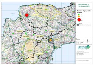
Figure 3.1: Devon wide map showing locations that were flooded.
3.2 Data and Information Collation
It should be noted that this report is only based on the information brought to the attention of DCC through its professional partners, the media and the public and where further investigation by the authorities have identified additional flooded properties. Therefore, it cannot be guaranteed to contain an exact or exhaustive list of individual properties or affected communities on the August 17th 2020 event.
3.3 Highway Infrastructure
During this event, significant surface water flooding affected the Highway network across Devon. Notable areas affected are detailed in the following list:
- Barnstaple Town Centre
- The Square in Barnstaple
- The A361 and the A39 were both blocked due to flooding, causing congestion on the surrounding roads
- Longbrook Street in Exeter was completely flooded
4. Extent and Impact of Flooding
4.1 Barnstaple
4.1.1 Flood Incident Extent and Impact
Barnstaple was the area worst affected during this flood event and also recorded the highest number of properties flooded during a single event since DCC became the Lead local Flood Authority in 2010. The extent of flooding was varied – with some areas of Barnstaple experiencing mainly external flooding to gardens and outbuildings, and others suffering from internal flooding to their dwelling or business. In total 164 properties flooded internally of which 118 were residential and 46 commercial. Figure 4.1 below is a zoomed in map showing the areas of Barnstaple where property flooding was experienced. The map identifies both the commercial and residential properties that were flooded and clearly demonstrates the localised but widespread flooding that was experienced within the town of Barnstaple. No further property flooding has been reported within other towns and villages in close proximity.
The flooding event on 17th August was as a result of high intensity rainfall that was very localised over the town of Barnstaple. This created significant volumes of surface water that overwhelmed the drainage systems to the extent that they were unable to drain away effectively. Once the peak of the storm passed the systems were able to catch up and within a few hours the flood water had drained away, leaving much devastation behind. As this was a single location event North Devon Council took the lead in organising the recovery phase, helping the affected residents with the clear up and also set up a local recovery fund to assist with material losses.
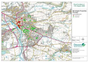
Figure 4.1: A map showing the commercial and residential properties flooded in Barnstaple
4.1.2 Historic Flooding
There has been previous flooding experienced in Barnstaple, with the following incidents recorded
- 29/10/2000: 2 properties flooded in the Bradiford area
- 10/10/2006: 4 properties reported to have flooded internally in the stick
- 03/01/2014: Highway flooding in the Square
- 19/01/2016: 2 properties flooded in the Signal Terrace/Clifton Terrace area
- 03/09/2016: Highway flooding in the Market Street area
- 05/09/2016: Highway flooding in the Raleigh Road area
- 19/11/2016: 3 properties flooded in the Bradiford area
- 20/11/2016: 5 properties flooded in Sherrats Oak, Raleigh
4.1.3 Data Gathered
There are no rainfall gauges in Barnstaple and with this intense rainfall event being extremely localised the nearby rainfall gauges outside of Barnstaple do not illustrate the extent of the rainfall experienced. However, a volunteer observer in Barnstaple recorded 61.6mm of rainfall. Figure 4.2 below shows the Rainfall Radar data for Barnstaple, taken at 16:55 by the Met Office, clearly identifying the peak intensity of the storm passing directly over the town.
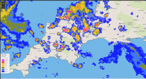
Figure 4.2: Rainfall Radar data for Barnstaple taken at 16:55 by the Met Office
4.1.4 Effect on the Highway
Many of the key roads were impassable and the traffic was brought to a standstill. The Square was an area of note which had high levels of surface water and was impassable. Furthermore, the A361 and the A39 were both blocked due to flooding, causing congestion on the surrounding roads. The flooding was a result of a very short duration, high intensity rainfall event, subsequently causing the local drainage network to be overwhelmed and rapidly surcharge, with flood water being unable to enter the system. Typically, these highway drainage systems are not designed to cope with such high intensity short duration rainfall events, the volume of water is therefore likely to have exceeded the drainage design capacity, but once the storm abated the flood water was able to drain away.
4.1.5 Previous Studies
Following the events of 2016, a high-level assessment was carried out to understand the surface water risk within the central area of Barnstaple. This determined that the highest concentration of properties at risk were within the town centre area and mainly commercial property. The funding mechanism available did not include commercial properties and therefore a cost beneficial scheme could not be justified to secure Flood Defence Grant in Aid from Defra. Barnstaple was prioritised accordingly.
4.2 Exeter
Central Exeter was another area that had a high level of internal property flooding. Six properties flooded internally, of which 5 were residential and 1 was commercial. Longbrook Street and Victoria Street were areas of note with high levels of surface water.
4.3 Devon-wide
A range of other areas were affected to a lesser extent across Devon including Crediton, Holsworthy, Newton Abbot, North Tawton and Okehampton. Between these areas, 5 properties flooded in total, all of which were residential. The intense rainfall and short duration of the localised storm led to a large volume of surface water overwhelming the drainage systems adjacent to the individual properties.
5.0 Recommended Actions
The following actions in Table 5.1 are recommended for the areas affected in this chapter.
Table 5.1. Recommended actions for the Barnstaple area.
- General actions recommended for the areas featured in this chapter:
| Action By | Recommended Action | How |
|---|---|---|
| LLFA/ Property Owners | Increase community resilience. | To install Property Flood Resilience (PFR) measures where necessary in liaison with appropriate Risk Management Authorities. Devon County Council Flood Risk Management (LLFA) currently has a PFR Funding Scheme. |
| DCC Highways | To ensure efficient operation of highway drains and culverts. | Review and carry out maintenance in problem areas and consider providing additional gullies |
| Parish/Town Council | Increase community resilience to affected community. | Ensure Community Emergency Plan is up to date. Support available from DCC and Environment Agency. |
| SWW | Ensure efficient operation of public combined and surface water sewers. | Continue maintenance regime and consider storm separation where appropriate. |
- Barnstaple
| Action By | Recommended Action | How |
|---|---|---|
| DCC Highways | To ensure efficient operation of highway drains and culverts. | Review highway gullies and consider whether any maintenance issues require attention. |
| DCC LLFA | Consider options for mitigating surface water flood risk to areas identified in the Barnstaple surface water investigation. | Progress with the Barnstaple surface water investigation to consider preferred options and opportunities for securing funding and resources for potential flood improvement works. |
| Property Owners | Consider flood risk to own properties. | To install PFR where necessary and make properties more resilient to flooding. |
| SWW | Ensure efficient operation of public combined and surface water sewers. | Continue maintenance regime and consider storm separation where appropriate. |
| Environment Agency | Consider interaction with main river and tidal influences on surface water discharges | Work with other RMAs to assist with holistic approach to flood risk management |
| North Devon Council / Environment Agency / DCC LLFA | To ensure flood risk is managed from new developments. | Encourage sustainable drainage practices for new developments. |
- Exeter
| Action By | Recommended Action | How |
|---|---|---|
| DCC LLFA / DCC Highways | Investigate any opportunities to improve the drainage in the area. | LLFA and DCC highways to work in partnership and prioritise in line with other workloads. |
| DCC LLFA | Consider options for improving surface water flood risk to areas identified in the Exeter SWMP. | Deliver actions identified in Exeter SWMP and consider PFR installations where appropriate. |
| Property Owners | Consider flood risk to own properties. | To install PFR where necessary and make properties more resilient to flooding. |
- Crediton
| Action By | Recommended Action | How |
|---|---|---|
| DCC LLFA | Identified in the local strategy as a high priority community. | Consider local opportunities to reduce risk in line with other priorities |
| Property Owners | Consider flood risk to own property. | To install PFR where necessary and make properties more resilient to flooding. |
- Holsworthy
| Action By | Recommended Action | How |
|---|---|---|
| DCC LLFA / DCC Highways | Investigate any opportunities to improve the drainage in the area. | Consider local opportunities to reduce risk. in line with other priorities |
| Property Owners | Consider flood risk to own property. | To install PFR where necessary and make properties more resilient to flooding. |
6.0 Next Steps
The next steps following this report will be for DCC as the LLFA to ensure that the recommended action tables in each chapter are presented to the responsible Risk Management Authority. DCC will consider their actions in line with other priorities and monitor delivery through regular reviews, whilst working in partnership with the EA, District Councils, South West Water and the local communities affected.
There is an expectation from DCC of itself and its partners that all authorities involved will cooperate and work together to improve the flood risk in the vulnerable areas identified in this report by completing the recommended actions. As the LLFA, DCC has a responsibility to oversee the delivery of these actions.
Where minor works and quick win schemes have been identified, these will be prioritised and subject to available funding and resources will be carried out as soon as possible by the relevant authority or landowner. Any major works requiring capital investment will be considered through the EA’s Medium-Term Plan process.
A review of the actions will be carried out by DCC as the LLFA in order to monitor progress and encourage delivery of recommended actions.