Section 19 Flood Investigation Report
This flood investigation report has been produced by Devon County Council as a Lead Local Flood Authority under Section 19 of the Flood and Water Management Act 2010.
| Version | Undertaken by | Reviewed by | Approved by | Date |
| Draft 1 | Thomas Aldridge, Jessica Bishop | Jessica Bishop | Martin Hutchings, Head of Flood and Coastal Risk Management | July 2025 |
| Final | Jessica Bishop, Principal Flood and Coastal Risk Officer | July 2025 |
This report covers the flooding incident during Storm Bert on 22nd – 25th November 2024 and has identified all flooded properties within the County that we have been able to determine or brought to our attention.
Introduction
The Flood Risk Regulations 2009 and the Flood and Water Management Act 2010 (the Act) have established unitary and upper tier local authorities as the Lead Local Flood Authority (LLFA) for their area. This has placed responsibilities on the LLFA in relation to flood risk management and in particular Section 19 of the Act which states:
| Flood and Water Management Act 2010: Section 19 – Local Authorities: investigations. On becoming aware of a flood in its area, a lead local flood authority must, to the extent that it considers it necessary or appropriate, investigate – which risk management authorities have relevant flood risk management functions, and whether each of those risk management authorities has exercised, or is proposing to exercise, those functions in response to the flood. Where an authority carries out an investigation under subsection (1) it must – publish the results of its investigation, and notify any relevant risk management authorities. Flood and Water Management Act (2010), S.19, c.29, London: HMSO |
A ‘Risk Management Authority’ (RMA) means:
(a) the Environment Agency (EA),
(b) a lead local flood authority,
(c) a district council for an area for which there is no unitary authority,
(d) an internal drainage board,
(e) a water company, and
(f) a highway authority.
When considering if it is necessary or appropriate to investigate a flood event Devon County Council (DCC) will review the severity of the incident, the number of properties affected and the frequency of such an occurrence. Devon’s Local Flood Risk Management Strategy clearly sets out the criteria to be used when considering a Flood Investigation Report.
Although not all of the locations in this report meet the significance threshold of 5 or more properties flooded, to ensure that the full extent of the flooding is appreciated and recorded it has been decided to include all locations brought to our attention which experienced any internal property flooding, and also other areas of particular concern.
In partnership with the other RMAs in Devon this report has been produced to comply with legislation and to determine the main causes of the flooding. It should be noted that in order to progress with their flood risk management function DCC has opted to develop this report further by considering the various actions that should be considered by the relevant RMA. DCC as the LLFA will continue to monitor the list of actions with all of the RMAs and will assist in the delivery where practical to do so.
It should be noted that this report is only based on the information brought to the attention of DCC through its professional partners, the media and the public and where further investigation by the authorities have identified additional flooded properties. Therefore, it cannot be guaranteed to contain an exact or exhaustive list of individual properties or affected communities.
Please note, reports of flood depths vary between metric and imperial measures depending on whether they have been measured or reported by others. To avoid giving the impression of precise depth measurements it has been actively chosen to not convert any imperial measurements provided by members of the public into metric measurements. For the purposes of clarity 1 inch would normally convert to 2.54cm.
Each affected area or group of smaller areas investigated within this report will have a number of recommended actions to be taken forward by the relevant RMAs or in some cases, by the landowner or local community action group. There are various levels of action that can be taken depending on the severity of the situation and the practical solutions available to reduce the risk of further flooding. The recommended actions will generally fall into one of the following categories:
Delivery of Quick win schemes: a solution that can be implemented quickly by the Risk Management Authorities or Local Authority at relatively low cost; some of these have already been completed as this report has been progressed.
Further investigation/research: Further investigations such as catchment studies and hydrological/hydraulic assessments to understand the flow rates and directional paths and evaluate the extent of flooding. These would provide evidence for future capital investment.
Development of future schemes: Where immediate action is not financially viable or a solution not readily available then a larger scale flood alleviation scheme may be required. In such cases national funding would need to be secured together with additional contributions from others, such as local levy, local authorities and other third parties.
Landowner action: Members of the public who own land adjacent to watercourses have riparian responsibilities and therefore have a duty to maintain their section of watercourse to ensure there is no impediment of flow. Other works to protect their property may also need to be funded by themselves to ensure delivery within their timescales.
Community action: In some cases, it may be prudent for community groups to join forces and deliver and maintain their own local schemes. There may be opportunities to generate further contributions from local levy or the LLFA.
This investigation report will provide a starting point, with suggested actions being further refined in the light of further studies and where possible, through further dialog with the affected communities.
| Recommended Actions: The purpose of this report is to act as a tool for all of the relevant RMAs to understand and appreciate the extent of flooding in their area and to consider and prioritise those actions relevant to their authority. Due to the extent of flooding, not only from the events covered in this report, but the level of recommended actions also far exceeds the budgets and resources available to enable them to be delivered immediately. Although we take all flooding issues seriously it should therefore be appreciated that some actions may not be progressed within the timescales expected by some residents or communities. Every effort will be made to progress the actions if and when suitable funding is obtained. The recommended actions highlighted in this report will be used by the LLFA to monitor progress achieved by the RMAs. |
Risk Management Authority Responsibilities
2.1 Recording Flood Incidents
LLFAs must record flood incidents as part of their duties under the Flood and Water Management Act. The information below shows the national guidance given as part of the Preliminary Flood Risk Assessment Spreadsheet submission to the EA, which outlines information to be collected by LLFAs.
Information the LLFA must record
Devon County Council (DCC) will record this on the DCC flood incident database:
- Start Date
- Days duration
- Probability
- Main source: surface water runoff; groundwater; ordinary watercourses; artificial infrastructure; main rivers; the sea; no data
- Main mechanism: natural exceedance; defence exceedance; failure; blockage or restriction; or no data
- Main characteristics: natural flood; flash flood; deep flood; snow melt flood; no data
- Significant consequences:
- To human health (residential properties)
- To economy (non-residential properties)
- To the environment (designated sites flooded)
2.2 Key Responsibilities
RMAs in Devon all have their own roles and responsibilities. The general RMA responsibilities in relation to flood risk and surface water management are outlined below:
The Environment Agency is responsible for managing the risk from the sea, Main Rivers and reservoirs and has a strategic overview role for all flood risk management, making it a key local partner for DCC, especially when managing the risk from combined sources and in the event of a large flood incident. The EA also provides a flood warning service throughout England and Wales in areas at risk of flooding from rivers or the sea.
Devon County Council as the Lead Local Flood Authority is responsible for overseeing the flood risk from ordinary Watercourses, groundwater and surface water runoff. They are also responsible for consenting to works on ordinary Watercourses and enforcing the removal of any unlawful structure or obstruction within the watercourse. And, as previously stated they must ensure that a flooding investigation is carried out by the relevant authority and publish a report. DCC must also prepare a Local Flood Risk Management Strategy and maintain a register of flood risk assets.
Local District Councils are classified as land drainage authorities with discretionary powers under the Land Drainage Act, such as the implementation and maintenance of flood defences on ordinary watercourses. They also have powers under the Public Health Act to ensure the removal of any blockage within an ordinary Watercourse that is considered a nuisance. As a planning authority they are responsible for the preparation of development plans and making decisions based on planning policy.
Devon County Council as the Highway Authority maintains the highway drainage system to reduce the amount of standing water on the highway. This is achieved by limiting the water on the roads and ensuring that they are kept clear of rainwater; including the maintenance of highway gullies and culverts.
National Highways is responsible for managing, maintaining and improving the Motorway and trunk roads across England and any associated drainage and flood risk.
South West Water (The Water Company) is responsible for the public sewerage network including foul, surface water and combined systems together with any associated assets such as pumping stations, sewage treatment works and combined sewer overflows.
Land/Property Owners that have a watercourse in or adjacent to their land have riparian responsibilities on that watercourse. This means the landowner must:
- Let water flow through their land without any obstruction, pollution or diversion which affects the rights of others.
- Accept flood flows through their land, even if these are caused by inadequate capacity downstream.
- Keep the banks clear of anything that could cause an obstruction and increase flood risk, either on their land or downstream if it is washed away.
- Maintain the bed and banks of the watercourse and the trees and shrubs growing on the banks and should also clear any litter or debris from the channel and banks, even if it did not come from their land.
- Keep any structures, such as culverts, trash screens and debris grills, weirs and mill gates, clear of debris.
The LLFA must also take an overseeing role to ensure that all flood risk is being managed appropriately.
In small, localised groundwater and surface water flooding incidents which do not reach the threshold level to trigger a flood investigation by the LLFA under Section 19, the Local Authorities will work in partnership to consider the appropriate action.
All RMAs have a duty to co-operate and to share information in relation to their flood risk management functions.
Incident Summary
3.1 Incident Summary
On 22nd to 25th November, Storm Bert brought significant winds and rainfall to the United Kingdom. In total, 42 properties suffered internal flooding in Devon. This included 36 residential and 6 commercial properties.
Over the affected weekend on Dartmoor Rundlestone saw wind gusts of almost 75mph, meanwhile White Barrow saw over 127mm of rain.
Table 3.1 lists the towns and villages affected during Storm Bert, together with the reported number of properties flooded in each location. Figure 3.1 shows the extent of these affected areas across the County.
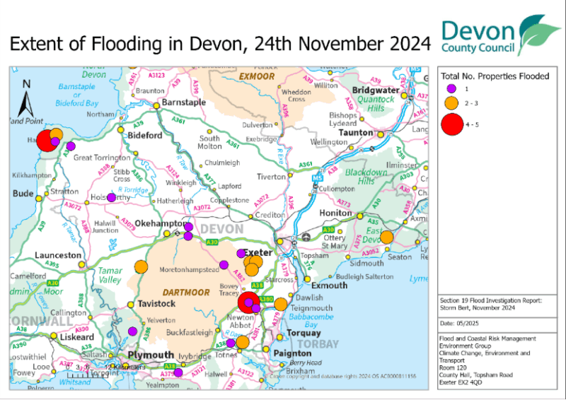
| Location | Number of properties flooded | Source of flooding |
| East Devon | ||
| Colyton | 2 | Groundwater/Surface Water |
| North Devon | ||
| Lee, Ilfracombe | 2 | Groundwater/Surface Water |
| South Hams | ||
| Week | 1 | Ordinary Watercourse |
| Westlake | 1 | Surface Water |
| Littlehempston | 2 | Surface Water |
| Teignbridge | ||
| Bridford/Christow Bridge | 3 | Main River |
| Doddiscombsleigh | 2 | Surface Water |
| Dunsford | 1 | Surface Water |
| Lower Ashton | 2 | Main River |
| Moretonhampstead | 1 | Surface Water |
| Newton Abbot | 5 | Ordinary Watercourse |
| Stover | 1 | Ordinary Watercourse |
| Teigngrace | 1 | Main River |
| Teignmouth | 3 | Surface Water |
| Torridge | ||
| Clovelly | 1 | Surface Water |
| Lymebridge | 4 | Ordinary Watercourse |
| Hartland Village | 3 | Ordinary Watercourse |
| Philam | 1 | Surface Water |
| West Devon | ||
| Holsworthy | 1 | Surface Water |
| Lydford | 2 | Surface Water |
| Milton Combe | 1 | Surface Water |
| Taw Green | 1 | Surface Water/Ordinary Watercourse/Sewer |
| South Tawton | 1 | Surface Water |
| Total properties flooded: 42 | ||
3.2 Impacts on the highway network
During this event between 22nd – 25th November, significant surface water flooding affected the highway network across Devon.
Numerous reports were received of tree and flooding on the road and other issues from wind damage, such as utility infrastructure and road signage.
- Flooding was reported on A377, A383, A379, A381, A3052, A3072, A382, A3124, A386, A361, A384, A388, A375.
- Trees reported down on A358, A386, A390, A379, A385, A381, A3122, A376, A377, A3072, A382, A396, A361, A39, A3052.
As part of the investigation, it will be recommended that Devon County Council Highways review the highway gullies and consider whether any maintenance issues require attention.
3.3 Incident response and recovery
When a flood event occurs, it is immediately followed by an emergency response and then recovery phase. There are many roles involved in this process, covered by the Emergency services, Environment Agency and local authorities. Details of this are included in the Multi-Agency Flood Framework. As the LLFA, DCC’s Flood & Coastal Risk Management team becomes involved at the recovery phase. This involves recovery coordination, community engagement and investigation.
Following any flood event, DCC will engage with relevant District Councils, Risk Management Authorities, local Parish and Town Councils and community members to gather information. This information is shared with other agencies to determine the extent of impact and will assist in the production of the Section 19 Flood Investigation Report.
Flood Incident Extent and Impact
This chapter details the extent and impact of the flood event, where the Section 19 reporting thresholds have been reached of 5 or more residential properties, 2 more commercial properties or significant infrastructure/receptors being flooded. All other flooded properties are included in Table 3.1.
Newton Abbot
In the Jetty Marsh industrial estate, five commercial properties were flooded from out of bank flows from nearby ordinary watercourses.
On Jetty Marsh Road, one unit was flooded when flows overtopped the adjacent flood embankment from Whitelake. There is a history of flooding at this location.
Further downstream by The Avenue, a further four units were flooded internally when flows came out of a nearby leat, most likely due to the high levels in Whitelakes downstream. There are no records of previous flooding at this location.
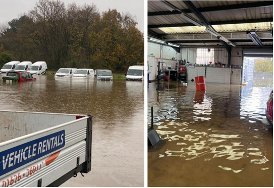
A breach of the old railway embankment and the Stover Canal, resulted in one million tonnes of water flooding the nearby Sibelco quarry and the closure of the Public Right of Way. Early investigations show that the breach is approximately 40 metres long and five metres deep. It is believed that the large amounts of water flowing into the quarry may have prevented more extreme flooding downstream in Newton Abbot. Work is now taking place to dewater the quarry and to consider necessary remedial works, including the rebuilding of the embankment and reinstatement of both the Templar Way and Stover Trail paths. Meetings have taken place between Sibelco, the Environment Agency, Devon County Council, Teignbridge District Council and the Stover Canal Trust to discuss this process and the many impacts on the local environment and community.
Recommended Actions
As a result of this investigation report, several recommendations have been made for actions to be taken in specific locations. These are either as a result of initial site or desktop investigations, or the continuation of works or investigations already in progress. DCC as the LLFA will continue to monitor and record all flood incidents that come to our attention and consider this within our action plan and future investment programme. The current action plan can be found on the DCC Flood Risk Management Website at https://www.devon.gov.uk/floodriskmanagement/. Table 5.1 below summarises the recommended actions for this flood incident.
As stated earlier in this document, the purpose of this report is to act as a tool for all the relevant RMAs to understand and appreciate the extent of flooding in their area and to consider and prioritise those actions relevant to their authority.
The recommended actions highlighted in this report will be used by the LLFA to monitor progress achieved by the RMAs.
| Action By | Recommended Action |
| General actions recommended for the areas featured in this chapter: | |
| EA /LLFA / Local communities | Where applicable assist with the development of community emergency/flood action plans. Advice and possible funding are available from Devon Community Resilience Forum to increase community resilience to all affected communities. |
| DCC Highways / National Highways | Review, and where required, carry out maintenance in problem areas to ensure efficient operation of highway drains and culverts. |
| District Council / EA / LLFA | Encourage sustainable drainage practices for new developments to ensure flood risk is managed from new development. |
| Property Owners / LLFA / EA | Consider flood risk to own properties and to install property level protection where necessary in liaison with appropriate Risk Management Authorities. |
| SWW | Continue maintenance regime and consider storm separation where appropriate to ensure efficient operation of public combined and surface water sewers. |
| In addition to the general actions the following should be considered at specific locations: | |
| Action By | Recommended Action |
| LLFA | In line with other priorities, to consider further investigation into the flooding mechanisms that occurred in Newton Abbot, working in partnership with the Environment Agency and Teignbridge District Council to build upon the most recent flood studies and modelling exercises for the area. |
Next Steps
The next steps following this report will be for DCC as the LLFA to ensure that the recommended action tables in each chapter are presented to the responsible Risk Management Authority. DCC will consider their actions in line with other priorities and monitor delivery through regular reviews, whilst working in partnership with the EA, District Councils, South West Water and the local communities affected.
There is an expectation from DCC of itself and its partners that all authorities involved will cooperate and work together to improve the flood risk in the vulnerable areas identified in this report by completing the recommended actions. As the LLFA, DCC has a responsibility to oversee the delivery of these actions.
Where minor works and quick win schemes have been identified, these will be prioritised and subject to available funding and resources will be carried out as soon as possible by the relevant authority or landowner. Any major works requiring capital investment will be considered through the EA’s Medium-Term Plan process.
A review of the actions will be carried out by DCC as the LLFA to monitor progress and encourage delivery of recommended actions.