Contents
Context
This flood investigation report has been produced by Devon County Council as a Lead Local Flood Authority under Section 19 of the Flood and Water Management Act 2010.
| Version | Undertaken by | Reviewed by | Approved by | Date |
| Final | Thomas Aldridge | Jessica Bishop | Martin Hutchings | 13/12/2023 |
This report covers the flooding incident on 18 June 2023 and has identified all flooded properties within the County that we have been able to determine or brought to our attention. Based on the criteria set out in our Local Strategy this single report covers the requirement for Section 19 Flood Investigation Reports.
1. Introduction
The Flood Risk Regulations 2009 and the Flood and Water Management Act 2010 (the Act) have established unitary and upper tier local authorities as the Lead Local Flood Authority (LLFA) for their area. This has placed a number of responsibilities on the LLFA in relation to flood risk management and in particular Section 19 of the Act which states:
| Flood and Water Management Act 2010: Section 19 – Local Authorities: investigations
1) On becoming aware of a flood in its area, a lead local flood authority must, to the extent that it considers it necessary or appropriate, investigate –
2) Where an authority carries out an investigation under subsection (1) it must –
Flood and Water Management Act (2010), S.19, c.29, London: HMSO |
A ‘Risk Management Authority’ (RMA) means:
- (a) the Environment Agency (EA),
- (b) a lead local flood authority,
- (c) a district council for an area for which there is no unitary authority,
- (d) an internal drainage board,
- (e) a water company, and
- (f) a highway authority.
When considering if it is necessary or appropriate to investigate a flood event Devon County Council (DCC) will review the severity of the incident, the number of properties affected and the frequency of such an occurrence. Devon’s Local Flood Risk Management Strategy clearly sets out the criteria to be used when considering a Flood Investigation Report.
In partnership with the other RMAs in Devon this report has been produced to comply with legislation and to determine the main causes of the flooding. It should be noted that in order to progress with their flood risk management function DCC has opted to develop this report further by considering the various actions that should be considered by the relevant RMA. DCC as the LLFA will continue to monitor the list of actions with all of the RMAs and will assist in the delivery where practical to do so.
It should be noted that this report is only based on the information brought to the attention of DCC through its professional partners, the media and the public and where further investigation by the authorities have identified additional flooded properties. Therefore, it cannot be guaranteed to contain an exact or exhaustive list of individual properties or affected communities.
Please note, reports of flood depths vary between metric and imperial measurements depending on whether they have been measured or reported by others. To avoid giving the impression of precise depth measurements it has been actively chosen to not convert any imperial measurements provided by members of the public into metric measurements. For the purposes of clarity 1 inch would normally convert to 2.54cm.
The area investigated within this report will have a number of recommended actions to be considered by the relevant RMAs or in some cases, by the landowner or local community action group. There are various levels of action that can be taken depending on the severity of the situation and the practical solutions available to reduce the risk of further flooding. The recommended actions will generally fall into one of the following categories:
Delivery of quick win schemes: a solution that can be implemented quickly by the Risk Management Authorities or Local Authority at relatively low cost; some of these have already been completed as this report has been progressed.
Further investigation/research: Further investigations such as catchment studies and hydrological/hydraulic assessments to understand the flow rates and directional paths and evaluate the extent of flooding. These would provide evidence for future capital investment.
Development of future schemes: Where immediate action is not financially viable or a solution not readily available then a larger scale flood alleviation scheme may be required. In such cases national funding would need to be secured together with additional contributions from others, such as local levy, local authorities and other third parties.
Landowner action: Members of the public who own land adjacent to watercourses have riparian responsibilities and therefore have a duty to maintain their section of watercourse to ensure there is no impediment of flow. Other works to protect their property may also need to be funded by themselves to ensure delivery within their timescales.
Community action: In some cases, it may be prudent for community groups to join forces and deliver and maintain their own local schemes. There may be opportunities to generate further contributions from other Risk Management Authorities.
This investigation report will provide a starting point, with suggested actions being further refined in the light of further studies and where possible, through further dialog with the affected communities.
| Recommended Actions:
The purpose of this report is to act as a tool for all of the relevant RMAs to understand and appreciate the extent of flooding in their area and to consider and prioritise those actions relevant to their authority. Due to the extent of flooding across the County, not only from the events covered in this report, but other significant events throughout the year, the level of recommended actions far exceeds the budgets and resources available to enable them to be delivered immediately. Although we take all flooding issues seriously it should therefore be appreciated that some actions may not be progressed within the timescales expected by some residents or communities. Every effort will be made to progress the actions if and when suitable funding is obtained. The recommended actions highlighted in this report will be used by the LLFA to monitor progress achieved by the RMAs. |
2. Risk Management Authority Responsibilities
2.1 Recording Flood Incidents
LLFAs must record flood incidents as part of their duties under the Flood and Water Management Act. The information below shows the national guidance given as part of the Preliminary Flood Risk Assessment Spreadsheet submission to the EA, which outlines information to be collected by LLFAs.
Information the LLFA must record
Devon County Council (DCC) will record this on the DCC flood incident database:
- Start Date
- Days duration
- Probability
- Main source: Surface water runoff; Groundwater; Ordinary watercourses; Artificial infrastructure; Main rivers; The sea; No data
- Main mechanism: Natural exceedance; Defence exceedance; Failure; Blockage or restriction; or No data
- Main characteristics: Natural flood; Flash flood; Deep flood; Snow melt flood; No data
- Significant consequences:
- To human health (residential properties)
- To economy (non-residential properties)
- To the environment (designated sites flooded)
2.2 Key Responsibilities
RMAs in Devon all have their own roles and responsibilities. The general RMA responsibilities in relation to flood risk and surface water management are outlined below:
The Environment Agency is responsible for managing the risk from the sea, Main Rivers and reservoirs and has a strategic overview role for all flood risk management, making it a key local partner for DCC, especially when managing the risk from combined sources and in the event of a large flood incident. The EA also provides a flood warning service throughout England and Wales in areas at risk of flooding from rivers or the sea.
Devon County Council as the Lead Local Flood Authority is responsible for overseeing the flood risk from Ordinary Watercourses, groundwater and surface water runoff. They are also responsible for consenting to works on Ordinary Watercourses and enforcing the removal of any unlawful structure or obstruction within the watercourse. And, as previously stated they must ensure that a flooding investigation is carried out by the relevant authority and publish a report. DCC must also prepare a Local Flood Risk Management Strategy and maintain a register of flood risk assets.
Local District Councils are classified as land drainage authorities with discretionary powers under the Land Drainage Act, such as the implementation and maintenance of flood defences on ordinary watercourses. They also have powers under the Public Health Act to ensure the removal of any blockage within an ordinary watercourse that is considered a nuisance. As a planning authority they are responsible for the preparation of development plans and making decisions based on planning policy.
Devon County Council as the Highway Authority maintains the highway drainage system to reduce the amount of standing water on the highway. This is achieved by limiting the water on the roads and ensuring that they are kept clear of rainwater, including the maintenance of highway gullies and culverts.
National Highways is responsible for managing, maintaining and improving the Motorway and trunk roads across England and any associated drainage and flood risk.
Land/Property Owners that have a watercourse in or adjacent to their land have riparian responsibilities on that watercourse. This means the landowner must:
- Let water flow through their land without any obstruction, pollution or diversion which affects the rights of others.
- Accept flood flows through their land, even if these are caused by inadequate capacity downstream.
- Keep the banks clear of anything that could cause an obstruction and increase flood risk, either on their land or downstream if it is washed away.
- Maintain the bed and banks of the watercourse and the trees and shrubs growing on the banks and should also clear any litter or debris from the channel and banks, even if it did not come from their land.
- Keep any structures, such as culverts, trash screens and debris grills, weirs and mill gates, clear of debris.
The LLFA must also take an overseeing role to ensure that all flood risk is being managed appropriately.
In small, localised groundwater and surface water flooding incidents which do not reach the threshold level to trigger a flood investigation by the LLFA under Section 19, the Local Authorities will work in partnership to consider the appropriate action.
All RMAs have a duty to co-operate and to share information in relation to their flood risk management functions.
3. Incident Summary
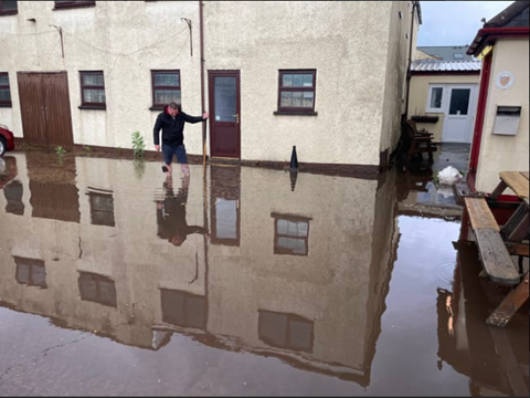
On the 18 June 2023, flooding was experienced in Crediton as a result of a short duration heavy rainfall event. Local drainage systems became overwhelmed which led to multiple properties flooding in Crediton. In total, nine properties suffered internal flooding (six residential and three commercial).
A Yellow Met Office Weather Warning was issued at 10:30am on Friday 16 June for heavy rain and thunderstorms to occur on Sunday 18 June across large parts of England and Wales.
Table 3.1 Record of towns affected
| Location | Number of properties flooded | Source of flooding |
| Mid Devon | ||
| Crediton | 9 | Surface Water |
| Total properties flooded: 9 | ||
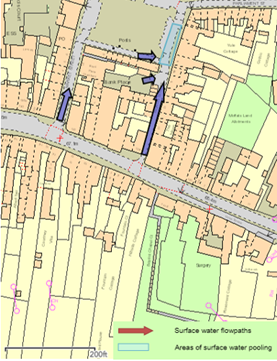
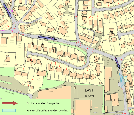
Table 3.1 lists the the reported number of properties flooded. These have been identified on Figure 3.1 and 3.2 to show the geographical extent of flooding across the town. Rainfall data for the event is visualised in Figure 3.1.
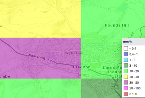
Data from HydroMaster estimates a peak rainfall intensity of 30-50mm/h with rainfall reported by residents as lasting for around 30 minutes. This was a short intensity high rainfall event.
3.2 Data and Information Collation
It should be noted that this report is only based on the information brought to the attention of DCC through its professional partners, the media and the public and where further investigation by the authorities have identified additional flooded properties. Therefore, it cannot be guaranteed to contain an exact or exhaustive list of individual properties or affected communities for the June 2023 event.
3.3 Highway Drainage and Sewerage Impacts
During this event on 18 June 2023 significant surface water flooding affected the Highway network in Creditonn. Highway drainage systems that feed into South West Water’s public surface water sewer were overwhelmed. As part of the investigation, it will be recommended that Devon County Council Highways review the highway gullies and that South West Water review the condition of their network, and both organisations consider whether any maintenance issues require attention.
4. Flood Incident Extent and Impact
4.1 Crediton
Flood Incident Extent and Impact
Surface water flooding to at least nine properties was recorded, mainly affecting roads off the A377 in Crediton including North Street and Mill Street. At least four properties were internally flooded on North St. One property nearby at The Burrowe was recorded as flooding. Two properties on Mill St were internally flooded. Flood depths internally ranged primarily from 1-10mm. On Mill Street external flood depths were reported as above 15cm. Primary surface water flow paths affecting property are shown in Figure 3.1.
There were isolated incidents related to what appears to be localised issues with drainage networks being overwhelmed, this included a single property on the A377 (Exeter Road) and at New Cut.
Properties along North Street and Mill Street are affected by surface water flows regularly with this event showing lower levels of internal flooding than August 2022. Historic flooding records show that the areas affected in June 2023 have been subject to a long history of surface water flooding due in part to the surrounding topography.
External flooding to a garage was reported by a property in Fairfield Road, Crediton and road flooding noted on Alexandra Road near Queen Elizabeth School.
Historic Flooding
The following is a record of some of the surface water flooding that has impacted upon the urban extent of Crediton. Flooding associated primarily with watercourses have not been incorporated within the below record.
Historic newspaper records show flooding as far back as the 1840s with multiple reports of surface water flooding to property in the centre of Crediton. In August 1875 North St reported flooding, and in May 1883 when surface water flooding was reported on the High St, Kiddicott, Cottwell, Parliament St, North St and the road now known as Mill St.
18/12/1983: 2 properties flooded from surface water runoff
25/09/1998: 2 properties flooded from surface water runoff on North St
18/04/2000: 1 property flooded along Exeter Rd from surface water runoff
13/12/2008: 1 property flooded from surface water along High St
14/02/2014: 1 property flooded assumed surface water runoff
30/12/2015: 1 property flooded from surface water along High St, 1 near miss along Greenway
5. Recommended Actions
As a result of this investigation report, several recommendations have been made for actions to be taken in specific locations. These are either as a result of initial site or desktop investigations, or the continuation of works or investigations already in progress. DCC as the LLFA will continue to monitor and record all flood incidents that come to our attention and consider this within our action plan and future investment programme. The current action plan can be found on the DCC Flood Risk Management Website at https://www.devon.gov.uk/floodriskmanagement/. Table 5.1 below summarises the recommended actions for this flood incident.
It should be noted that these recommended actions will need to be considered by the relevant authority or responsible property/landowners and prioritised accordingly within their existing and future investment programmes. All flooding is taken very seriously however, to manage expectations, it will not be possible to carry out all actions immediately along with existing workload and available funding. Some may require further detailed investigations with the development of a robust cost beneficial business case to secure funding, prior to any scheme design and delivery. In practice this can take many years to deliver.
Table 5.1. Recommended actions for Crediton
|
Action By |
Recommended Action |
How |
| General actions recommended for the areas featured in this chapter: | ||
| EA /LLFA / Local communities | Increase community resilience to all affected communities. | Where applicable assist with the development of community emergency/flood action plans. Advice and possible funding available from Devon Community Resilience Forum. |
| DCC Highways | To ensure efficient operation of highway drains and culverts. | Review and carry out maintenance in problem areas |
| Property Owners / LLFA / EA | Consider flood risk to own properties. | To install property level protection where necessary in liaison with appropriate Risk Management Authorities. |
| SWW | Ensure efficient operation of public combined and surface water sewers. | Continue maintenance regime and consider storm separation where appropriate. |
| In addition to the general actions the following should be considered at specific locations: | ||
|
Crediton | ||
| LLFA/DCC | Consider options for a town centre surface water management scheme | Feed in information into DCC’s ongoing surface water study for Crediton |
6. Next Steps
The next steps following this report will be for DCC as the LLFA to ensure that the recommended action tables in each chapter are presented to the responsible Risk Management Authority. DCC will consider their actions in line with other priorities and monitor delivery through regular reviews, whilst working in partnership with the EA, District Councils, South West Water and the local communities affected.
There is an expectation from DCC of itself and its partners that all authorities involved will cooperate and work together to improve the flood risk in the vulnerable areas identified in this report by progressing the recommended actions. As the LLFA, DCC has a responsibility to oversee the delivery of these actions.
Where minor works and quick win schemes have been identified, these will be prioritised and subject to available funding and resources will be carried out as soon as possible by the relevant authority or landowner. Any major works requiring capital investment will be considered through Defra’s current or future six year Programme.
A review of the actions will be carried out by DCC as the LLFA to monitor progress and encourage delivery of recommended actions.