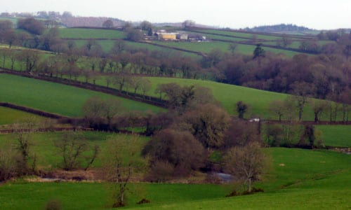
A gentle agricultural landscape of high scenic quality, characterised by ribbon-like rivers. Slow-flowing, meandering streams fringed by trees glide through quiet, inaccessible floodplains. A semi-regular pattern of fields, edged with hedges and earth banks, covers the undulating landform and adds pattern and texture to the landscape. The area feels remote and peaceful, and away from Okehampton has seen very little C.20th development; the scattered stone-built farms and villages have a timeless quality. Narrow, earth-banked lanes thread across the valleys, contrasting with the A30 which cuts across the landscape.
- Context
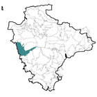
 This roughly V-shaped area comprises the upper valleys of the rivers Tamar and Thrushel and their tributaries the Carey, Deer, Lyd, Lew and Wolf, extending from just east of Launceston in Cornwall northwards to Holsworthy and eastwards towards Okehampton. The western boundary of the area corresponds to the county boundary with Cornwall. To the north there are gradual transitions to the Western Culm Plateau and the High Torridge Culm Plateau. To the east are the Broadbury Ridges and to the south the Middle Tamar Valley, Tamar Upland Fringe and Tavistock Dartmoor Fringes. The boundaries with the latter two areas are marked by the transition to higher ground with a stronger moorland influence.
 - Constituent Landscape Character Types
Constituent LCTs:2D: Moorland Edge Slopes, 3B: Lower Rolling Farmed and Settled Valley Slopes, 3C: Sparsely Settled Farmed Valley Floors, 3G: River Valley Slopes and Combes, 3H: Secluded Valleys, 5A: Inland Elevated Undulating Land
Part of NCA:149: The Culm - Distinctive Characteristics
- Underlying geology of Carboniferous Culm rocks comprising mudstone, siltstone and sandstone.
- Gently undulating topography, with occasional steeper-sided river valleys.
- Larger rivers meandering through narrow floodplains, fed by smaller, steeper tributary streams.
- Occasional plantations and woodland blocks, particularly on south-facing valley sides.
- Lines of riparian trees following the meandering courses of the rivers and contrasting with the straighter lines of field boundaries.
- Parkland estates and scattered orchards giving parts of the area a more wooded character.
- Brown loam soils supporting mainly pasture, but with some arable on flatter, better-drained land.
- Variable field pattern, with unenclosed floodplains, small-medium sized irregular fields in the narrower valleys and larger, more regular fields (reflecting later enclosure) on higher ground.
- Fields separated by hedgerows and locally-distinctive tall earth banks (sometimes stone-faced). Some curvilinear medieval strip fields survive, e.g. around Cookworthy shrunken village.
- Watermeadows and wet pasture alongside rivers, and very occasional patches of rough ground known locally as ‘moors’.
- Natural and artificial lakes (including part of Roadford Lake Reservoir); associated semi-natural habitats.
- Prehistoric features including barrow cemeteries along straight ridge-top roads, hilltop enclosures at Hele and east of Lifton, and coaxial fields at Meldon.
- Historic features often associated with rivers, e.g. bridges, mills and weirs, stone bridges across the Tamar marking the boundary between Devon and Cornwall.
- Palimpsest of archaeological sites at Sourton, including civil war redoubt, battlefield and remnants of Roman road.
- Remnants of industrial activities including stone extraction and mining visible in the landscape.
- Stone or cob linhays (animal shelters) locally distinctive features of the agricultural landscape.
- Sparse settlement consisting of scattered farmsteads and occasional clustered villages, often at crossroads; houses built of local stone with warm grey/red tones, with slate or thatched roofs.
- Current and former communications routes utilising the gentle topography, including the A30, stretches of the old main road to Cornwall, and disused railway lines following the Carey and Lyd valleys.
- Network of sinuous lanes, often enclosed by high hedgebanks; valley bottoms less accessible by road.
- Quiet, uncluttered landscape, with open, expansive views from higher land where hedgebanks permit.
Evaluation
- Special Qualities and Features:
- Widespread sense of timelessness, resulting from the lack of 20th century built development.
- Dark night skies away from the influence of Launceston and the A30.
- High levels of tranquillity around the edges of the area, locally reduced by main road corridors.
- Views to and from the northern part of Dartmoor National Park, contributing to its setting.
- Occasional blocks of ancient woodland, often associated with parkland estates, including Sydenham House and Hayne Manor, both of which are on the Register of Historic Parks and Gardens.
- Scattering of traditional orchards, especially north and east of Launceston, and around Wrixhill Bridge.
- CWSs including Roadford Lake Reservoir, wet woodland and valley-side woodland sites.
- Prehistoric features (barrow cemeteries at Sandymoor Cross and Upcott Moor, and hilltop enclosures at Hele and Lifton) designated as SMs.
- Several defensive sites designated as SMS, including Sourton Civil war redoubt; medieval motte and bailey at Burley Wood; and Okehampton Castle.
- Many historic structures associated with rivers (particularly the Lew), such as bridges, weirs, ponds and mills e.g. Bidlake Mill and Leat SM.
- Conservation Areas covering the historic cores of Germansweek, Lifton and Emworthy.
- Good network of quiet lanes and public rights of way, including the Two Castles Trail.
- Roadford Lake Reservoir popular for recreation, with walks, fishing, sailing and camping.
Forces for Change and Their Landscape Implications:
- Past and Current
- A30, which cuts across the grain of the landscape, bringing visual intrusion and reducing tranquillity.
- Agricultural intensification and conversion of pasture to arable, resulting in some loss of traditional hedgebanks and semi-natural habitats such as wet pasture and rough grassland.
- Loss of orchards, particularly on valley slopes.
- Past replanting of ancient woodland with coniferous plantation.
- Invasive water-borne weeds such as Himalayan Balsam, knotweed and hogweed colonising river banks to the detriment of native riparian vegetation.
- Farm diversification including equine activities, fishing lakes and game bird shoots which introduce new elements into the landscape.
- Construction of Roadford reservoir resulting in loss of farmsteads and historic landscape features.
- Linear spread of housing on the edges of settlements that is visually prominent on ridgelines (e.g. St Giles on the Heath).
- Future
- Uncertainty over future agricultural incomes, potentially leading to further diversification and structural changes in agriculture, with impacts on the character of the landscape.
- Increased demand for renewable energy schemes, including wind farms, bio-energy crops and small-scale domestic schemes with a cumulative impact on the landscape.
- Climate change, potentially affecting growing seasons for crops and species composition of woodlands; and bringing new pests and diseases, increased rainfall and greater flood risk.
Strategy
- Overall Strategy:
To protect the area’s scenic quality, and its undeveloped agricultural landscape, and to enhance its local distinctiveness and biodiversity value. Sustainable agriculture is supported, and traditional agricultural features such as hedgerows, linhays and earth banks are managed and repaired as necessary. The biodiversity of the area is increased through the good management of woodlands, watermeadows, wetlands, rough grassland and other semi-natural habitats. Archaeological and historic sites (including country estates) are protected and managed appropriately. The traditional sparse settlement pattern and undeveloped character of the area are respected, but the river valley landscapes are opened up through the establishment of recreational routes along the disused railway lines.
Guidelines:
- Protect
- Protect remaining hedgerows, linhays and locally-distinctive tall earth banks.
- Protect remaining orchards and manage appropriately; restore former orchards where possible.
- Protect the existing pattern of scattered settlement and nucleated villages, ensuring any new development is small in scale, sensitively sited and respects local vernacular styles and materials (whilst incorporating sustainable design).
- Protect the open and undeveloped qualities of the landscape, and respect its role within the setting of Dartmoor National Park.
- Protect ancient and historic features to ensure their continued presence in the landscape.
- Protect dark night skies, seeking to reduce light pollution from Launceston and the A30.
- Manage
- Manage agricultural land through continuation of traditional pastoral land use, and ensuring that where farm diversification does occur it has minimal impact on the landscape.
- Manage arable field margins as ecological corridors.
- Manage areas of wet pasture and rough ground to maximise their biodiversity.
- Manage roadside verges and banks to maximise their biodiversity and habitat potential.
- Manage invasive water-borne weeds through appropriate methods of control.
- Manage historic parkland estates and ancient woodland to maximise species and age diversity.
- Manage flood banks where necessary to ensure their continued effectiveness.
- Manage plantations for sustainable timber production, enhanced wildlife value, and investigate the opportunities for their recreational use.
- Plan
- Plan to investigate the potential for opening up disused railway lines as recreational routes (with minimum negative impact on the landscape).
- Plan to link areas of semi-natural habitat such as woodlands and wetlands, including through the sensitive reinstatement of lost medieval field boundaries, particularly in the Tamar and Lew valleys.
- Plan for reversion of coniferous plantation to native broadleaved woodland at maturity and felling, avoiding damage to known archaeology; encourage the replanting of historic woodlands where these have been lost.