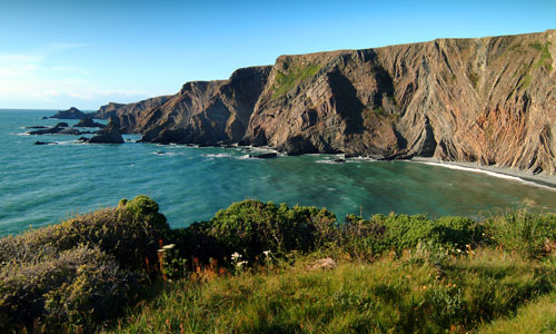
In the Hartland Peninsula, complex geology, combined with centuries of pounding by the full force of the Atlantic waves, has produced some of the most dramatic seascapes and coastal scenery in Devon. The cliffs are high and rugged, with zig-zag faults and folds. Wave-cut platforms and spectacular coastal waterfalls are also distinctive features of this jagged, exposed and windswept coastline, with the profile of Lundy visible in the open seascape. Coastal heathland on the cliff tops produces vivid and changing colours for much of the year. Inland, the area contains an open, flat, elevated plateau of agricultural land, which contrasts with the twisting, wooded and secretive combes that are cut into the plateau at its coastal edge. Dramatic sunsets over the sea add to the drama of the area.
- Context
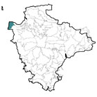
 This area comprises the south-western part of the North Devon coast. It is bordered by the sea to the north and west, and by the county boundary with Cornwall to the south. To the east there is a gradual transition to the Bideford Bay Coast and a more abrupt transition (marked by the prevalence of unimproved Culm grassland) to the Western Culm Plateau.
 - Constituent Landscape Character Types
Constituent LCTs: 1B: Open Coastal Plateaux, 3H: Secluded Valleys, 4D: Coastal Slopes and Combes, 4H: Cliffs Part of NCA: 149: The Culm - Distinctive Characteristics
- Carboniferous Culm rocks folded and faulted into extraordinary shapes, with twisted, zig-zag strata clearly visible in the cliffs.
- Erosion by the sea creating extensive wave-cut platforms and coastal waterfalls which contribute to the dramatic seascape.
- An undeveloped coast of rocky headlands and pebbly bays, many of which are inaccessible.
- Inland, relatively flat plateau land, incised by steep combes running down to the sea.
- Occasional hedgerow trees and shelterbelts on the open plateau; woodland (usually ancient and oak-dominated) confined to the coastal combes, where it is a distinctive feature.
- Relatively poor soils, traditionally supporting pastoral agriculture.
- Fields irregularly shaped, and of varying sizes, divided by hedgerows and hedgebanks; remnant strip field systems around Milford Common and Hardisworthy.
- Extensive semi-natural habitats, including inaccessible cliffs and shoreline, oak woodland and colourful coastal heath, which support a rich diversity of plants, insects, animals and birds.
- An ancient landscape, containing the Iron Age hillfort at Embury Beacon, and medieval settlements, lanes, churches and fields which are still integral to the landscape fabric today.
- Other historic features that include ancient wells, historic parkland (around Hartland Abbey), watermills, relics of former industry such as limekilns and the remains of Hartland Quay; and black and white wooden finger posts at road junctions are a distinctive feature of the lanes.
- A dispersed pattern of ancient farmsteads, hamlets and villages – including the larger settlements of Welcombe and Hartland – connected by an intricate network of lanes, with wide verges and high hedgebanks.
- Distinctive skyline buildings such as Stoke Tower (one of the highest in Devon) and Hartland Point radar dome; Lundy as a landmark in open sea views.
- Great contrasts between the open coastal plateau with its long views and big skies, and the dramatic coastline with its enclosed, wooded combes.
Evaluation
- Special Qualities and Features:
- Outstanding scenic quality and seascapes within the North Devon Coast AONB and Heritage Coast.
- A sense of remoteness, with levels of tranquillity and dark night skies across the area among the highest in Devon.
- Extensive nature conservation designations including Marsland-Clovelly Coast SAC (also designated SSSI for its outstanding geology and coastal habitats) and North Devon Biosphere Reserve.
- Concentrations of ancient oak woodland in the coastal combes, often with SSSI or CWS designation; Marsland Valley LNR; and RIGS sites at Colpit Quarry, Hartland Quay and Embury Beacon.
- SMs at Embury Beacon Iron Age hillfort, and St Clare’s well at Philham.
- Numerous listed buildings including farmhouses, farm buildings, bridges, mills, pubs, cottages and quays; St Nectan’s Church (Stoke) listed Grade I; Conservation Area at Hartland.
- Some of the most substantial hedgebanks in Devon, which have a tunnel-like quality where the lanes go down into the combes. Locally-distinct wide verges support a range of flowers and insects.
- A good network of lanes and public rights of way (including the South-West Coast Path) providing recreational access into the area, with common and/or access land along much of the cliff tops.
- Significant areas of land owned and managed by the National Trust (the Welcombe Estate and part of the Brownsham Estate).
Forces for Change and Their Landscape Implications:
- Past and Current
- Farm diversification changing the traditional character of the landscape, and adding new elements.
- A trend towards larger farm buildings which are not of traditional character, and are often visually intrusive in the landscape.
- Conversion of old agricultural buildings to holiday/ residential accommodation.
- Changes to land holding patterns, such as amalgamation of holdings to increase farm viability, and the break-up of farms when farmhouses are purchased separately from their land.
- Past loss of coastal heathland as a result of loss of grazing or enclosure for agricultural use.
- Modern animal welfare and compliance requirements which mean that grazing of much of the cliff land is no longer practical, due to its extreme ruggedness and inaccessibility, even with agri-environment scheme support.
- Past loss of species- rich pastures including Culm grassland through agricultural intensification.
- Past loss of unimproved grassland and heath through abandonment of steep valley sides.
- Lack of management of Embury Beacon hillfort, resulting in scrubbing-up.
- Small-scale landscape impacts from tourism and recreation, such as litter, unauthorised camping, and traffic on narrow lanes (particularly around Hartland).
- Introduction of skyline features such as communications masts.
- Insensitive design of new housing developments e.g. in Hartland
- Agri-environment scheme funding that is enabling some habitat restoration through scrub control and reintroduction of grazing in the Welcombe Valley; also reversion of agriculturally-improved land to coastal grassland e.g. at South Hole and East Titchberry farms.
- Future
- Uncertainty over future agri-environment funding, potentially affecting farm viability and management of landscape features and wildlife habitats such as hedgerows, coastal valley slope heaths and grasslands, and cliff-top pastures.
- Changes in seasonal weather patterns and the introduction of new species, pests and diseases due to climate change, potentially affecting agriculture and habitats such as woodland and heath.
- Higher sea level and storm frequency as a result of climate change leading to increased coastal erosion; the Shoreline Management Plan recommends ‘no active intervention’ along this stretch of coast, potentially causing ‘coastal squeeze’ between the eroding shoreline and agricultural land behind.
- Growth in renewable energy sources, including biomass crops, offshore and onshore wind farms (e.g. the proposed Atlantic Array), and domestic-scale renewables which potentially have a cumulative landscape impact.
- Future growth of Hartland village as a local centre affecting the appearance and character of the settlement.
- Increased demand for tourist accommodation (caravan sites, hotel developments etc).
- Spread of pests and diseases such as Phytophthora changing the character of habitats such as woodlands and heaths.
Strategy
- Overall Strategy:
To protect the landscape’s scenic quality, rural character, strong sense of place and distinctive seascapes within the North Devon Coast AONB. The area’s internationally-important coastal and woodland habitats are protected and managed to strengthen them against climate change. The spectacular geology of the area is appreciated and enjoyed. The historic fabric of the area is protected and enhanced. Current agricultural land use is sustained, and distinctive landscape features (such as the exceptionally big hedgebanks) are retained. Sustainable recreational use of the area is encouraged, but the undeveloped character of the coast is retained.
Guidelines:
- Protect
- Protect the area’s high scenic quality.
- Protect the distinctive, dramatic and open seascapes and the undeveloped character of the coast.
- Protect sites designated for their biodiversity or cultural value, particularly the relatively rare coastal habitats and sites. Protect geological sites, and provide appropriate management and interpretation where necessary.
- Protect historic and archaeological sites, including the clearance and interpretation of Embury Beacon hillfort
- Protect the qualities of local lanes and hedgebanks, resisting highways improvements and intrusive signage.
- Protect and conserve locally-distinctive black and white wooden finger posts.
- Protect the open and undeveloped qualities of the coastal plateau.
- Manage
- Manage semi-natural coastal habitats to maximise their biodiversity value and strengthen their resistance to coastal squeeze and/ or climate change; restore and develop areas of coastal heath and cliff-top grassland including Culm grassland, and create buffer zones between cliff communities and improved agricultural land where possible.
- Manage farmland, and sustain current agricultural use, keeping buildings, hedgerows and hedgebanks in good repair; where farm diversification does occur, ensure it has minimal impact on the character of the landscape.
- Manage woodland (including the use of traditional techniques such as coppicing) to maximise age diversity and to achieve species diversity appropriate to the local conditions.
- Manage the land within the North Devon Coast AONB and North Devon Biosphere Reserve in accordance with the AONB’s statutory duties and the guidelines of the Biosphere Reserve.
- Manage recreation and transport so that local people and visitors can enjoy the landscape in a sustainable way.
- Plan
- Plan to ensure settlement growth is sympathetic to traditional forms and styles, whilst incorporating sustainable design.
- Plan to create links between existing areas of semi-natural habitat to maximise their biodiversity value, and to extend habitat back from the cliff-top in order to re-create greater extent of coastal grassland and heath (to compensate for loss of habitat on cliffs that are no longer grazeable, restore damage though past agricultural intensification of cliff-top fields, and to mitigate against loss through coastal erosion).