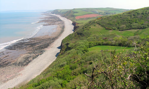
Deep combes cloaked in oak woodland wind inland from the wooded cliffs, with carpets of bluebells in spring. Streams rush down the valleys, and ferns thrive in the dark, damp conditions. The woodland paths, with their glimpsed views of the sea, have a sense of intimacy, secrecy and peace. Narrow lanes with high, fern-covered banks provide access to the sheltered combe villages of Bucks Mills and Clovelly, the latter with its picturesque harbour and whitewashed houses. On higher land behind and between the combes is a lush landscape with a rolling patchwork of fields, a peaceful settled feel, and views of the woodlands and the sea. There are open sea views across Bideford Bay towards the Taw-Torridge estuary, with Lundy a distinctive feature on the horizon.
- Context
 This area encompasses a sweep of coastal land from Beckland Bay (near Exmansworthy) to Westward Ho! To the north is the sea, and to the east (beyond the settlements of Westward Ho! and Appledore) is the Taw-Torridge Estuary. To the south is a transition to the Torridge Valley (marked by a change in landform) and the Western Culm Plateau (marked by the change in dominant vegetation to Culm grassland and plantation). To the west is a gradual transition to the Hartland Peninsula.
 - Constituent Landscape Character Types
Constituent LCTs: 4D: Coastal Slopes and Combes, 5B: Coastal Undulating Farmland, 4H: Cliffs Part of NCA: 149: The Culm - Distinctive Characteristics
- Underlying Culm Measures geology, with strata running east-west, parallel to the coast, giving the cliffs a tendency to landslips, and a distinctive rounded ‘hog’s back’ profile.
- Coastal outcrop of Permian Sandstone between Portledge and Peppercombe, visible as a distinctive red patch on the cliffs.
- Striking coastal landforms including Blackchurch Rock and truncated waterfall below Windbury Head.
- A relatively sheltered bay, with gentler, more rounded coastal scenery than elsewhere along the coast.
- Extensive coastal oak woodlands, containing important lichens, ferns and ground flora within the sheltered combes; bluebells a dominant feature in spring.
- Southern and eastern areas dominated by agriculture on medium-quality soils, with rolling, irregularly-shaped pastoral and arable fields extending to the cliff tops.
- Fields (including medieval strip-patterns around Woolfardisworthy) divided by hedgerows and banks with wind-sculpted hedgerow trees; field boundaries less frequent in the north-east around Abbotsham.
- Semi-natural habitats include inaccessible shoreline, wooded and heathy cliffs, pockets of unimproved grassland and marshland (including Culm grassland), road verges and species-rich hedgerows and hedgebanks, including fern habitats.
- Impressive Iron Age defensive sites, including Clovelly Dykes and promontory forts at Windbury Head, Peppercombe Castle and Bucks Mills.
- Historic coastal features including quays, lime kilns and Clovelly harbour; inland historic parkland contributes to the historic character of the landscape and provides rich wildlife habitat.
- Historic railway linking Bideford, Westward Ho! and Appledore (1904-1917) through the Abbotsham cliff area, today forming part of the coastal path out of Westward Ho!.
- Coastal settlement of scattered farms and picturesque linear villages (Clovelly and Bucks Mills) running down steep valleys to the sea; nucleated villages of Woolfardisworthy and Parkham further inland.
- Sunken rural lanes with exceptionally high hedgebanks connecting villages, contrasting with the A39 which runs through the area.
- Attractive landscape with pleasing compositions of woodland, farmland and coastal scenery.
- Open seascapes, including views of Lundy Island and across Bideford Bay to the Taw-Torridge estuary.

Evaluation
- Special Qualities and Features:
- Exceptionally high scenic quality; mainly part of the North Devon Coast National Landscape.
- Localised sense of remoteness, seclusion and intimacy, particularly in wooded combes.
- Moderately dark skies, although localised light pollution from Northam.
- Nationally and internationally important shoreline, cliffs, coastal heathland and coastal oak woodland habitats (Marsland-Clovelly Coast SAC and coastal SSSI).
- CWSs covering woodland, grassland and wetland sites along the coast and further inland.
- Coastal RIGSs between Mouthmill and Clovelly and at the Portledge to Peppercombe Permian outlier.
- Significant areas of extensive semi-natural ancient woodland in coastal combes.
- SMs including well-preserved Iron-Age sites at Clovelly Dykes and Windbury Head, ancient well sites and the 18th century Kenwith Castle.
- Conservation Areas at Clovelly and Bucks Mills, plus numerous listed buildings including farm houses, farm buildings, country houses and industrial structures such as limekilns.
- Designed ornamental and parkland landscapes at Clovelly Court, Portledge and Cornborough, with Clovelly Court supporting nationally-significant numbers of ancient trees rich in lichen epiphytes.
- Large areas of land in National Trust ownership, mainly in the western and central parts of the area (including the Brownsham Estate, coastal land at Portledge and unimproved pastures and woodland in the Peppercombe Valley)..
- Strong literary associations, with Clovelly becoming a tourist destination following references to the village in Charles Dickens’ A Message from the Sea (published 1860).
- Westward Ho! (the only English town to be named after a book) built following the success of Charles Kingsley’s book set in the area (published 1855); childhood home of Rudyard Kipling.
- Strong recreational appeal, including Clovelly Harbour and Buck’s Mills ‘honeypot’ sites and the South-West Coast Path.
Forces for Change and Their Landscape Implications:
- Past and Current
- Decline in traditional woodland management, particularly of cliff-side woodlands.
- Past localised replanting of broadleaved combe woodlands with coniferous plantation, changing the character of the valleys and reducing biodiversity.
- High levels of tourism and day visitors, reducing tranquility around honeypot sites in summer and bringing parking problems and traffic jams on narrow lanes.
- Visual impacts associated with large tourism sites such as Bideford Bay holiday village as well as smaller-scale issues of unauthorised camping and litter.
- Pressure for development of new large hotels, and the expansion of permanent structures in holiday parks.
- Intensification of agriculture, amalgamation of farm units and construction of large farm buildings (often very visible within the landscape); associated loss of wetland and grassland habitats; localised loss of hedgerows, bringing a more open character to the landscape.
- Farm diversification schemes such as campsites and farm accommodation converted from former agricultural buildings.
- Built development at Westward Ho! intruding onto the skyline in views from the National Landscape.
- Urban fringe uses such as horse paddocks around Northam.
- Restoration of wildlife habitats including reintroduction of grazing in formerly abandoned areas of Windbury Hill Fort and Brownsham Meadows Culm grassland.
- Future
- Uncertainty over future agri-environment funding, potentially affecting farm viability and management of landscape features such as hedgerows and habitats such as unimproved Culm grassland and heath.
- Potential climate change impacts on agriculture and habitats such as coastal woodland and heath, as a result of changes in seasonal weather patterns and introduction of new species, pests and diseases.
- Higher sea level and storm frequency as a result of climate change leading to increased coastal erosion and risk of landslides along the cliffs.
- Potential ‘coastal squeeze’ and loss of historic coastal features such as the lime kilns at Buck’s Mills, as the Shoreline Management Plan recommends ‘no active intervention’ along this stretch of coast (except for Clovelly, which will continue to be protected).
- Growth in renewable energy sources, including biomass crops, offshore and onshore wind farms (including the proposed ‘Atlantic Array’), and domestic-scale renewables which potentially have a cumulative landscape impact.
Strategy
- Overall Strategy:
To protect the landscape’s very high scenic quality, and its characteristic juxtaposition of farmland, wooded combes and coastal scenery. The area’s valuable natural and semi-natural habitats (including the coastal oak woodlands) are well managed and extended where possible. Sustainable agriculture is encouraged and the farmland is well-managed. The area’s archaeological and built heritage is protected and well-managed. People continue to enjoy the area, but its popularity as a tourist destination is not to the detriment of its landscape. The resilience of the area’s ecological systems to climate change is strengthened and its valued seascapes are protected.
Guidelines:
- Protect
- Protect open skylines, vistas and sea views.
- Protect the area’s distinctive coastline and open seascapes.
- Protect characteristic qualities of seclusion and remoteness in combes.
- Protect the undeveloped character of the coast where it remains.
- Protect winding rural lanes, resisting unsympathetic signage and highways improvements.
- Protect dark night skies, and investigate opportunities to minimise light pollution from Northam and nearby settlements.
- Protect (and sensitively restore if necessary) heritage features such as mills, limekilns and quays, providing low-key interpretation where appropriate.
- Protect locally-distinctive vernacular building styles, ensuring that any new development is sympathetic in style, form and location (whilst incorporating sustainable design).
- Manage
- Manage and enhance ancient coastal and combe woodlands through traditional techniques such as coppicing as well as removal of invasive species.
- Manage semi-natural habitats such as coastal heathland, Culm, maritime grassland and less-improved valley pastures (including through locally-appropriate grazing regimes) to retain a mosaic of vegetation types, and create buffer zones between cliff communities and improved agricultural land behind.
- Manage farmland, and encourage farmers to continue to farm ‘marginal’ areas as an integral part of their farming system, and to protect these areas from alternative land uses.
- Manage and extend wet woodland and wet meadows through appropriate grazing and traditional land management, to enhance their wildlife value and capacity for flood prevention.
- Manage Devon hedgebanks, respecting locally-distinctive styles; replace lost and over-mature hedgerow trees.
- Manage parkland and ornamental grounds through (for example) replacement of mature trees and extensive grassland management that protects parkland trees from root damage through nutrient enrichment, compaction and stock damage.
- Manage archaeological sites, with sustainable clearance, access and interpretation as necessary.
- Manage the land within the North Devon Coast AONB and North Devon Biosphere Reserve in accordance with the AONB’s statutory duties and the guidelines of the Biosphere Reserve.
- Plan
- Plan restoration of conifer plantations to native broadleaved woodland.
- Plan to link habitat types to create wildlife corridors and enhance biodiversity.
- Plan to develop a sustainable transport strategy to minimise tourist traffic.
- Plan for the future effects of climate change, allowing natural processes to occur as much as possible, whilst involving local people in the decision-making process.
- Plan for habitat roll-back as coastal cliffs retreat by managing cliff top land extensively to reduce nutrient levels.
- Plan to ensure that future development of adjacent settlements will respect sensitive skylines.