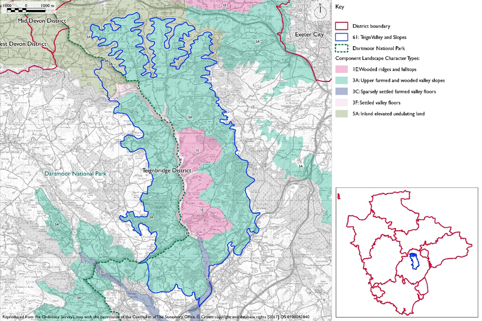
- Constituent Landscape Character Types
3A: Upper Farmed and Wooded Valley Slopes
5A: Inland Elevated Undulating Land
1E: Wooded Ridges Undulating Land
3F: Settled Valley FloorPart of National Character Area: 150: Dartmoor
- Contextual Description
This area comprises the middle Teign valley between Dunsford in the north and Chudleigh in the south. It is a linear landscape with a north-south orientation flanked to the north by the higher ridges of the Yeo Valley Uplands, to the west by the rising fringes of Dartmoor and to the east by the wooded Haldon Ridge.
Summary Description
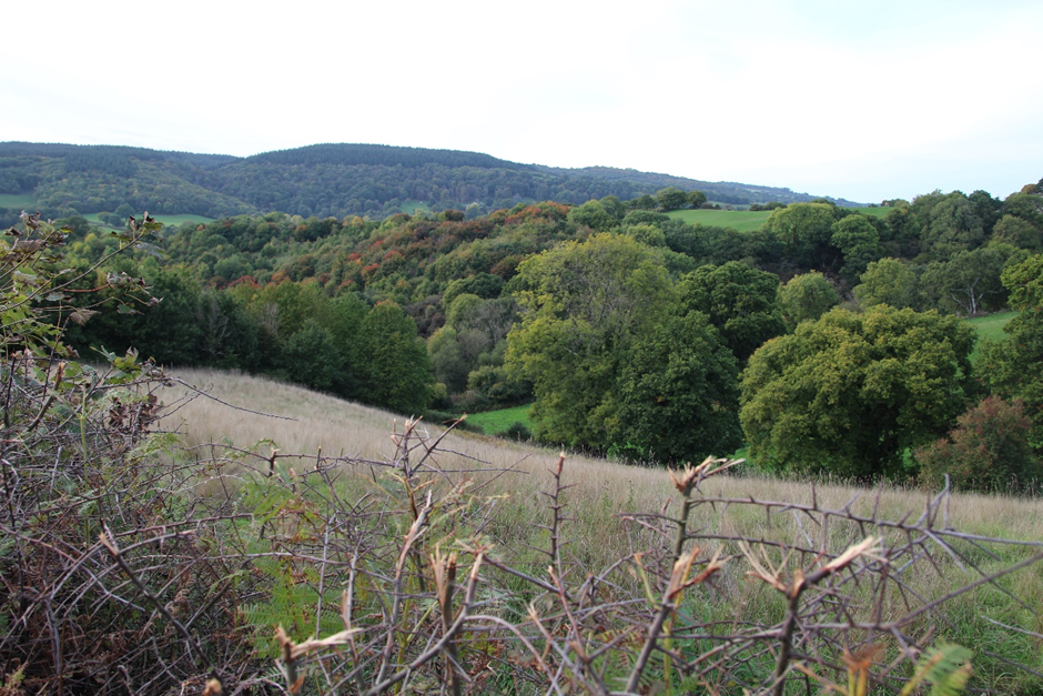
The Teign valley is perhaps the most dramatically steep and consistently wooded valley in Devon. Its steep, deep, narrow valley, twisting course, woodlands and nearby moor on Dartmoor are inspiring. It provides a wooded and often rocky flank to the eastern boundary of Dartmoor National Park. The steepness of the valley sides is accentuated by the height of the land either side, giving it a distinctive appearance in the wider landscape. The valley floor is relatively narrow (even in the south) and is flat-bottomed, open and marked by the tree-lined course of the river with occasional historic stone bridges, which add interest. Frequent broadleaved woodland along the valley sides (some ancient), gives a heavily wooded appearance, although many areas are in fact pastoral. These are marked by small, irregular fields with mature hedges and broken by a series of interlocking tributary valleys – particularly to the north where the valleys become narrower and more intimate. This is a landscape with high levels of tranquillity and dark night skies. Within the valley are scattered settlements and farmsteads and there has been a history of mining, reflected in the now dismantled railway.
- Distinctive Characteristics
- Underlain by sedimentary rocks which have been metamorphosed by the heat of the igneous granite intrusion of Dartmoor.
- Metalliferous deposits that have been mined on a small scale since the thirteenth century – hence small abandoned quarries and manganese and barytes mines along the valley sides as well as the larger active Trusham Quarry to the south of the area.
- Steep-sided, narrow river valley, tributary valleys and undulating slopes.
- Intimate river corridor highlighted by sinuous belts of woodland; frequent broadleaved woodland on steep slopes and extensive mixed woodland fringing the Haldon Ridge.
- Strong contrast between the flat-bottomed, narrow valley floor, marked by tree-lined course of the river and adjacent, steeper, rougher textured valley sides.
- Patchwork of small-scale, irregular field pattern with pasture and a mature and historically intact network of hedgebanks which often have individual and linear groups of trees growing on them.
- Semi-natural habitats including species-rich hedgebanks (often denoting ancient boundaries), semi-improved grasslands, scrub and ancient broadleaved woodlands.
- Cultural heritage features include stone bridges, small disused quarries, occasional historic mills and a dismantled railway (Teign Valley Line) following the course of the Teign and Sowton/Culver Brook.
- Occasional remnant deer parks and orchards.
- Settlement pattern of scattered farmsteads, hamlets and occasional small historic, intact villages, usually nestled along valley slopes above the valley floor.
- Vernacular buildings of stone, including granite, dolerite and slate or lime-washed cob and thatch.
- Network of winding, enclosed, narrow lanes and minor roads linking settlements.
- Very strong sense of tranquillity, except where disturbed locally in the south where the A38 crosses the valley and active quarrying occurs and there are some leisure developments.
- Channelled views along Teign valley and views west to Dartmoor and east to the Haldon Ridge from upper slopes and hills.
- Dark night skies that predominate through much of the area.
Evaluation
- Special Qualities and Features
- Landscape strongly defined by the rugged upland of Dartmoor National Park to the west and the wooded Haldon Ridge to the east giving a strong integrity to this landscape.
- Strongly recognisable sense of place and wide visibility from surrounding countryside.
- Complex landscape of high scenic quality, combining a strong landform with frequent woodland, a strong pattern of pasture fields with hedgebanks, narrow winding lanes and vernacular buildings.
- Remnants of historic industries, along with ancient woodland and boundaries, and charcoal burners’ hearths adding interest and diversity.
- Many natural heritage features, including semi-improved grassland (much designated as CWS or SSSI), broadleaved and ancient woodland, scrub, river and stream corridors, mature trees and hedgerows.
- Many cultural heritage attributes, including disused quarries and mines, a dismantled railway, historic bridges, mills and vernacular buildings, remnant deer park and orchards.
- Conservation Areas in villages of Doddiscombsleigh, Higher and Lower Ashton and Trusham, reflecting intact historic character.
- Strong sense of tranquillity overall and dark night skies.
Forces for Change and Their Landscape Implications
- Past and Current
- Scenic quality eroded to an extent at the southern edge by an active quarry, the A38 and an industrial site.
- Decline in mining with abandonment of quarry and railway.
- Conifer plantations on sites of ancient woodland and on valley sides.
- Loss of orchards due to lack of management.
- Pressure for new solar farms and masts.
- Need for farms to have slurry tanks in response to new waste management regs – increasing industrialisation of farmsteads.
- Future
- Potential agricultural intensification, leading to loss of traditional field boundaries and change to existing landscape patterns and industrial-style slurry tanks that are potentially not in scale and character of traditional farmsteads.
- Pressure for new masts, wind turbines and solar farms, which could have a very high visual impact on the elevated areas of this scenic landscape.
- Break up of traditional farmsteads into multiple ownership and use for non-agricultural practices such as equine development.
- Construction of new, large-scale agricultural buildings, which would be out of context with existing traditional, smaller-scale buildings.
- Potential road improvements and roadside developments along the A38, leading to an erosion of rural character.
- Potential development connecting active quarries straddling the River Teign.
- Peripheral development to settlements and construction of large extensions to existing houses and buildings in high visibility locations such as valley sides, resulting in visual intrusion and erosion of characteristic vernacular built form.
- Conversion of traditional agricultural buildings and attached land for domestic and leisure use, leading to unsympathetic boundary and surfacing treatments and erosion of rural character.
- Widening and new access points to narrow lanes, eroding their rural character.
- Potential for new leisure and recreation development, affecting the rural character and sense of tranquillity.
- The change /transition to the new land management system (ELMS) promises to be positive for the environment- more so than the CAP- and offers opportunity to strengthen landscape features and characteristics.
- Need for landfill/landraising within construction sites and modification of natural topography.
- Need for attenuation basins as part of SuDS as a requirement of new development.
Strategy
- Overall Strategy
To protect the valley and the pattern of pastoral fields, broadleaved woodlands, hedgebanks and narrow lanes that is fundamental to the integrity of this character area. New development is integrated sensitively within the existing landscape pattern of small-scale pastoral fields, mature woodland, hedgebanks and narrow lanes and reflects the small-scale, scattered settlement pattern and vernacular character. Recreation is sensitively developed and the special qualities of the landscape are interpreted.
Guidelines
- Protect
- Protect the overall strong sense of tranquillity and dark night skies, resisting highway improvements and lighting schemes that would affect these special qualities.
- Protect the small-scale, scattered settlement pattern of farmsteads, hamlets and small villages and ensure that new development reflects the existing vernacular character of thatch, cob, stone and slate.
- Protect and maintain channelled views along the Teign Valley and views across the landscape from upper slopes and hills.
- Protect the intimate character of the narrow valley floor, ensuring that new development conserves the River Teign, historic stone bridges and intact historic settlement pattern.
- Protect the route of the disused Teign Valley Railway for potential reopening or recreational use.
- Manage
- Manage the mature hedgerow network, particularly ancient boundaries, using traditional hedgerow management practices.
- Manage individual and linear groups of trees growing on the hedgebanks and replace trees where they have been lost.
- Manage historic features including historic stone bridges and settlement Conservation Areas.
- Manage using traditional techniques (particularly coppicing) the landscape’s semi-natural woodlands, to promote a diverse age and species structure and provide low carbon fuel for local communities.
- Manage semi natural grasslands and riparian habitats including damp meadows through appropriate grazing and traditional land management regimes – both to enhance their wildlife value and assist flood prevention.
- Manage the area’s existing plantations for sustainable timber production and wildlife interest, creating new green links to surrounding semi-natural habitats; explore their use as recreational spaces away from more sensitive habitats which surround them.
- Manage areas of semi-natural habitat. Link and extend habitats where possible to increase biodiversity, contribute to nature recovery networks and provide suitable habitats for flora and fauna.
- Plan
- Plan for the sensitive location of new development, avoiding prominent open valley sides and hills, locations visible from sensitive locations within 5km of Dartmoor National Park.
- Plan for the expansion of fragmented semi-improved natural grassland sites to create an intact and climate-resilient green network where conditions allow (i.e. considering underlying geology and soils).
- Restore and manage areas of relic traditional orchards and explore opportunities for the creation of new ones, including community orchards to promote local food and drink production.
- Plan for the long-term restoration to open habitats and broadleaved woodland (as appropriate) of the more prominent conifer plantations.
- Plan to mitigate climate change impacts allowing natural process to take place where possible.
- Plan a landscape-led response to the UK-wide policy drive for increased tree and woodland planting, implementing Devon Local Nature Partnership’s ‘Right Place, Right Tree’ principles to create a balance of climate-resilient native species appropriate to the local landscape.
- Plan to contribute to nature recovery networks and provide suitable habitats for flora and fauna.
- Plan for new slurry tanks to be grouped with other farm buildings, recess into ground, use natural topography and trees for screening and integration and sensitive colour treatment with dark recessive colour to minimise visual impact.
- Plan for landfill/landraising of development sites and modification of natural topography by designing new landform in character with topographic context, avoid artificial engineered landforms, and integrate into the landscape.
- Plan for attenuation basins as part of SuDS required as part of development designing for biodiversity and amenity enhancement, where possible to enhance development not just provide engineering function.