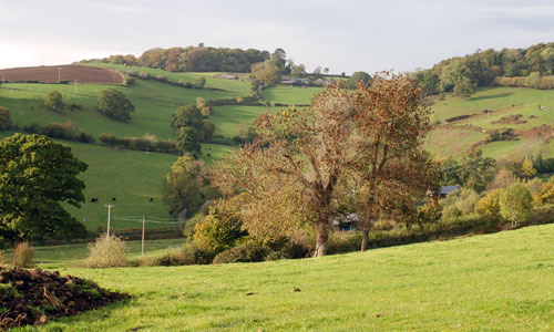
The landscape includes an extensive area of moorland fringe comprising rolling hills, many of which contain pockets of open heathland commons, and in the west an area of distinct plateau. The plateau land is dominated by conifer plantations associated with the Kennick, Tottiford and Trenchford reservoirs, around which is a gently undulating mixed farmed landscape interspersed by belts of woodland and rough heathy grassland. Here the enclosure pattern, where it is evident, is medium to large in scale and regular in form, which contrasts with the intricate pattern of medieval and post-medieval fields further west. The landscape is sparsely settled and crossed by a network of minor lanes and there is a strong sense of history presented through a rich scattering of archaeological sites and stone crosses. The generally open character of the area in the west affords long views, including views to the high Dartmoor moorland.
- Context
 This area comprises the north-eastern edges of Dartmoor National Park and includes an expansive area of enclosed moorland edge and farmed slopes and a more forested plateau in the east. Bounded to the west and south by the rising and open landscape of Central Dartmoor and High Dartmoor North, this area of enclosed pastoral land contains the distinctive incised upper and middle Teign valley. To the north there is a gradual transition to the Yeo Uplands and Slopes while to the east the change in character into the Teign Valley and Slopes is relatively abrupt.
 - Constituent Landscape Character Types
Constituent LCTs: 2D: Moorland Edge Slopes, 3D: Upland River Valleys, 1J: Farmed and Forested Plateau. Part of NCA: 150: Dartmoor - Distinctive Characteristics
- The eastern side of the granite ‘dome’ of Dartmoor, but with a complex, undulating topography containing rolling hills with pockets of upland common.
- Upland areas have smooth skylines, occasionally broken by rocky tors and boulders.
- Narrow, fast-flowing and rocky streams resulting from geological uplift of the Dartmoor plateau and including the steep upper and middle reaches of the Teign valley.
- Extensive areas of deciduous and mixed woodland, particularly in the Teign Valley; elsewhere, woodland generally limited with a high concentration of plantation woodland in the east.
- Mainly pastoral, with some arable farming on lower land; medieval enclosure pattern in the west, enclosed by dry-stone walls, hedgebanks or hedgerows; more regular pattern of enclosure in the east.
- Distinctive individual and linear groups of trees growing on hedgebanks in places.
- Outlying upland areas (e.g. Mardon Down, Butterdon Down and Cranbrook Down) of close-grazed unimproved grass moorland and common.
- Diverse semi-natural habitats, including heath, broadleaved woodland, wood pasture, mires and wet grassland.
- Considerable visible archaeology including prehistoric stone circles, numerous burial cairns, hut circles, field systems, hill forts, medieval farmsteads, stone crosses and more recent industrial remains including tin working, leats and quarries.
- Settlement generally consisting of isolated farms and small villages in valleys and tucked into sheltered folds of the hills; also the larger settlement of Moretonhampstead.
- A strong local vernacular tradition using local granite and slate.
- A network of twisting, sunken lanes which can give a sense of disorientation.
- Abrupt contrasts in landscape colour and texture between open moorland and enclosed farmland.
- Unexpected and impressive views onto the moorland and across the Teign valley.
Evaluation
- Special Qualities and Features:
- A landscape of very high scenic quality that is largely within Dartmoor National Park and is an important part of the setting to high Dartmoor.
- A high degree of tranquillity and sense of remoteness, particularly on higher land, and within enclosed lanes and valleys.
- Dark, starlit night skies, particularly away from the influence of Moretonhampstead.
- Extensive areas of ancient woodland, particularly in the upper and middle reaches of the Teign valley.
- Many valued habitats, including SSSIs and CWSs on valley mires, semi-improved neutral grasslands, streams and woodland, as well as wood pasture (Whiddon Deer Park SSSI) and heathland (Piddledown Common) supporting rare species.
- RIGS covering geological exposure associated with tin working and aplitic rock.
- Very strong sense of time depth, with prominent Iron Age hill-top prehistoric forts of Wooston, Prestonbury and Cranbrook Castles overlooking the Teign valley; and numerous prehistoric and medieval SMs on the moorland (including prehistoric hut circles, walled enclosures and medieval stone crosses).
- Conservation Areas at Moretonhampstead, North Bovey, Throwleigh, Chagford and Murchington plus numerous historic houses, farms, stone bridges and villages and a Historic Park and Garden (Grade II*) and castle designed by Edwin Lutyens at Castle Drogo in the Teign Valley.
- Unusually strong, intact field patterns of small, irregular medieval fields on the valley slopes, divided by stone walls, hedgebanks and hedgerows.
- Extensive upland commons e.g. Mardon Down, Butterdon Down and Cranbrook Down with open access land; and an excellent network of lanes and public rights of way on lower slopes.
- Two Moors Way long distance route crossing the area.
Forces for Change and Their Landscape Implications:
- Past and Current
- Visual and noise impacts of the A382, reducing tranquillity.
- Loss of upland semi-natural habitats due to over-grazing of outlying areas of moorland common.
- Concentrations of livestock in some riverside locations causing poaching on river banks and diffuse pollution.
- A lack of woodland management resulting in a localised loss of species diversity.
- Intensification of agriculture and a gradual loss of traditional skills such as stone walling resulting in decline of traditional agricultural landscape features such as hedgebanks.
- Intensive recreational use of upland areas resulting in erosion and damage to paths; and damage to geological and archaeological features and pressure at key sites e.g. Blackingstone Rock.
- Extensive planting of conifer plantations particularly in the east.
- Development of reservoirs in the 19th century including Kennick, Tottiford and Trenchford Reservoirs.
- Loss of heathland in the Teign Valley due to inadequate grazing to prevent incursion of secondary woodland.
- Future
- Development pressure from within and outside the National Park leading to potential demand for new water supply reservoirs and aggregate quarries.
- Further recreational demand from expanding urban centres in the vicinity, such as Exeter and Newton Abbot.
- Increased areas of coniferous plantation and woodland to filter water, minimise downstream flooding, store carbon and provide low carbon fuel (through coppice management).
- Potential loss of or change in oak and beech-dominated valley woodlands and conifer plantations due to spread of Phytophthora, intolerance of water level extremes and more frequent storm events.
- Intensification of agriculture and a gradual loss of traditional skills such as stone walling, resulting in decline of traditional agricultural landscape features such as hedgebanks.
- Intensive recreational use of upland areas resulting in erosion and damage to paths; damage to geological and archaeological features; and pressure at key sites.
- Changes in agricultural grants and funding potentially affecting grazing levels and the repair of traditional landscape features such as hedgebanks.
- Climate change potentially affecting growing seasons, temperature and precipitation levels, resulting in habitat loss and changes in species composition.
- Increased autumn and winter precipitation leading to higher water levels and consequent increases in poaching of river banks and flood risk in lower catchments.
- Future demand for wind turbines and communications masts on higher ground, and for domestic and community-scale renewables (including photovoltaic panels), with cumulative impacts on the landscape.
- Potential additional future hydro-power schemes.
- Break up of traditional farmsteads into multiple ownership and increase in ‘horsiculture’.
Strategy
- Overall Strategy:
To protect the landscape’s scenic quality and open skylines as well as enclosed, tranquil, unspoilt river valleys, and to strengthen its special qualities and features and enhance its appearance as the setting to high Dartmoor in views from the east. The area’s strong historic character is protected and enhanced. The time-depth associated with archaeological sites, field patterns and historic settlements is retained. Sustainable agriculture is supported, and upland commons are managed to increase their biodiversity through appropriate management and grazing, while ancient semi-natural woodlands and wet habitats are well managed to increase their longevity, and opportunities are sought to re-link sites where feasible. Recreation and enjoyment of the landscape is encouraged, but without detriment to fragile sites or features; and a new landscape structure is planned in areas of conifer plantation.
Guidelines:
- Protect
- Protect key views that contribute to the National Park’s setting.
- Protect and appropriately manage the landscape’s numerous historic sites and features, including prehistoric hut circles, hillforts, medieval crosses and twentieth century mining features.
- Protect and maintain the small-scale medieval field patterns on the valley sides, restoring hedgebanks and walls using traditional techniques and materials.
- Protect and maintain linear groups of trees growing on hedgebanks.
- Protect the area’s sparsely settled character and views to high moorland and across the Teign valley; carefully control new development outside existing settlement envelopes.
- Protect the strong unifying local vernacular of granite and slate; new development should utilise similar materials and styles whilst seeking to incorporate sustainable design.
- Protect the open skylines and resist development of vertical structure which would be prominent.
- Protect distinctive geological features, including the granite tors, removing scrub through appropriate grazing where necessary, and provide guidance and interpretation to enhance public understanding.
- Protect the landscape’s network of quiet lanes enclosed by species-rich hedgebanks, resisting unsympathetic highways improvements or signage.
- Protect and repair characteristic built features such as stone hump-backed bridges.
- Protect high levels of tranquillity and dark night skies, resisting developments which would damage these qualities.
- Manage
- Manage archaeological sites and their settings, with sensitive interpretation as necessary.
- Manage and enhance areas of upland common through appropriate levels of livestock grazing to enhance biodiversity.
- Manage and enhance the wildlife interest of the farmed landscape through the creation of species-rich grass buffers around arable fields and retention of areas of rough grazing and heathy scrub to preserve elements of Dartmoor character.
- Manage and enhance wetland habitats, particular wet woodland and valley mires and marshy grassland.
- Manage and enhance the valleys’ semi-natural woodlands and ancient woodlands (particularly in the Wray Valley) through traditional techniques (including coppicing and grazing) to promote longevity, species diversity and wood fuel.
- Manage recreational pressure (particularly in ‘honeypot’ sites) to minimise damage to habitats, wildlife and archaeological features; promote alternative locations and sustainable transport options.
- Plan
- Plan to create, extend and link semi-natural habitats such as broadleaved woodlands, heathlands, wetlands, and meadows.
- Plan to explore the area’s potential for additional hydro-power schemes where they can be sensitively incorporated into the landscape.
- Plan green infrastructure networks between Moretonhampstead and the surrounding countryside, to improve landscape connectivity and provide a framework for potential future sustainable development.
- Plan for long-term restructuring of large conifer plantations, aiming for better integration of plantations with open moorland by softening plantation edges with broadleaves, opening up important views, and encouraging use of plantations for recreation.