- Constituent Landscape Character Types
Constituent Landscape Character Types
3B: Lower Rolling Farmed and Settled Slopes
4C: Coastal Slopes and Combes with settlement
4H: Cliffs
1B: Coastal Open Plateau
Part of National Character Area
148: Devon Redlands
- Contextual Description
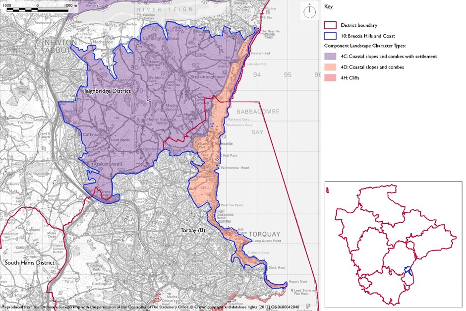
 This is a coastal landscape comprising an area of undulating high ridges dissected by deep narrow valleys and traversed by a maze of sinuous lanes and ancient greenways. These ridges are clearly defined on all sides and stand out as distinctive from the surrounding land; the northern edge of the area is marked by the Teign Estuary and the southern edge by the built development of Torquay and Torbay. To the east is the sea and to the west the settlements of Newton Abbot and Kingskerswell set on the valley sides of the Aller Brook. To the south, the area extends as a narrow finger of coastal open plateau between Torquay resort and the sea as far as Hope’s Nose.
Summary Description
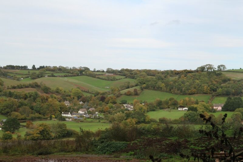
The Breccia Hills and Coast is a strongly undulating and highly dissected landscape of deep winding valleys with intervening high rounded ridges, and coastal slopes and combes, with steep red sandstone cliffs along the coast itself. Coastal influence is felt throughout much of the area, with extensive estuary and sea views from the high ridges and coast and estuary slopes providing a strong sense of place. Dense hedgerows and narrow, winding lanes are characteristic, along with small blocks of mixed and broadleaved woodland, occasional old orchards and small parks and tree-lined streams. This landscape has a deeply rural character with scattered farmsteads and small villages within the narrow valleys. Overall, sense of tranquillity is strong, even close to the nearby large settlements of Shaldon, Torbay, Kingskerswell and Newton Abbot, by virtue of the separating steep ridges.
- Distinctive Characteristics
- Strongly undulating, highly dissected landscape of deep valleys and high ridges and combes at the coast.
- Underlying sandstone and breccia geology gives rise to distinctive red soils visible in ploughed fields, hedgebanks and coastal cliffs (e.g. The Ness and Bundle Head); limestone in the south at Hope’s Nose headland.
- Small woodland blocks (often including pine and tree-lined streams.
- Easily worked red soils, giving rise to a patchwork of irregular pasture and arable fields, with some medieval enclosures delineated by mature, dense hedgerows.
- Habitats that include sandstone cliffs and rocky headlands, coastal scrub, intertidal sand/shingle and rocks, mixed and broadleaved woodland and mature hedgerows and trees.
- Historic features including remnant medieval enclosures, small parks, old orchards, vernacular buildings and prehistoric hillfort at Milber.
- Network of narrow, winding lanes and greenways, frequently following ridges.
- Scattered farmsteads, hamlets and small nucleated villages, with frequent cob, thatch, stone or render and slate vernacular buildings.
- Occasional leisure developments on the edges of Shaldon and Torbay and the A379 close to the coast.
Evaluation
- Special Qualities and Features
- High scenic quality and strong sense of place due to strong and distinctive landform of undulating deep valleys and high ridges, dramatic estuary and coastal views, and patchwork of fields, hedgerows and woodlands.
- Partly within the English Riviera European Geopark and WHS, designated for its geological diversity and including numerous geological SSSI and GCR sites along the coast to Hope’s Nose.
- Strong sense of tranquillity even close to large settlements as a result of the separating steep ridges, although locally reduced close to A379, Torbay and Kingskerswell.
- Coastal scrub, intertidal and cliff-side habitats, some of which are SSSIs; notable areas of mixed farmland with birdlife interest designated as CWS.
- Many cultural heritage features including historic greenways, medieval field patterns, vernacular buildings and historic settlements (Conservation Areas at Stockeninteignhead and Coffinswell), old orchards, and Milber Down Camp (hillfort and SM).
- Historic Park and Garden at Watcombe Park and Brunel Manor with notable woodland and avenues.
- Panoramic views from many ridges and slopes across the Teign estuary, towards Teignmouth, along the coast and out to sea.
- High recreational value due to proximity to centres of population and high scenic quality of the coast e.g. South West Coast Path.
Forces for Change and Their Landscape Implications
- Past and Current
- Erosion of tranquillity locally near the A379 coast road, St Marychurch Road, slopes above Kingskerswell and fringes of Torbay.
- Impact of development on the outskirts of the area resulting in light pollution and reduction of dark skies.
- Masts on high ground e.g. Great Hill.
- Recreational pressure along the coast adjacent to Torbay, with increased use and erosion of coastal footpaths, golf course development (e.g. Torquay and Shaldon Approach) and occasional camping and caravan sites.
- Decline of orchards and woodland due to lack of appropriate management regimes.
- Planting of conifers in places affecting nature conservation interest of the combe woodlands.
- Pressure to modify natural topography to accommodate flood risk management and other engineering schemes.
- Pressure for new solar farms and masts.
- Need for farms to have slurry tanks in response to new waste management regs – increasing industrialisation of farmsteads.
- Future
- Pressure for urban expansion of Newton Abbot, Kingskerswell and Torbay, potentially encroaching on the separating ridges and eroding rural character and tranquillity.
- Pressure for development associated with existing villages creating linear or ribbon development along valleys.
- Potential new leisure and recreation development along the coast road and fringes of nearby settlements, further affecting coastal and sea views and eroding rural character and tranquillity.
- Construction of large extensions to existing dwellings and new buildings in high visibility locations on ridges and open slopes, resulting in visual intrusion and erosion of vernacular character.
- Conversion of traditional agricultural buildings and attached land for domestic and leisure use, which can lead to unsympathetic boundary and surfacing treatments and erosion of rural character.
- Potential agricultural intensification, with loss of traditional field boundaries and old orchards and a change to existing landscape pattern.
- Construction of new, large-scale agricultural buildings, which can be out of scale with existing traditional, smaller-scale buildings and industrial-style slurry tanks that are potentially not in scale and character of traditional farmsteads.
- Widening and new access points to narrow lanes, eroding their rural character.
- Pressure for new masts and wind turbines, which would be potentially highly visible on prominent ridges.
- Pressure for new solar farms which could have a very high visual impact on this elevated landscape.
- Demand for domestic and community-scale renewable energy installations such as solar panels, small wind turbines and ground-source heat pumps – leading to incremental change to traditional buildings.
- Further planting of conifers, affecting the nature conservation interest of the combe woodlands.
- The change /transition to the new land management system (ELMS) promises to be positive for the environment- more so than the CAP- and offers opportunity to strengthen landscape features and characteristics.
- Need for landfill/landraising within construction sites and modification of natural topography.
- Need for attenuation basins as part of SuDS as a requirement of new development.
Strategy
- Overall Strategy
To protect and manage the rural character and historic time-depth evident in the pattern of green lanes, fields and settlements; and to maintain the sense of contrast with surrounding conurbations. New development conserves extensive views across the landscape to the coast and estuary and sea views from the cliffs themselves. The character of the undeveloped high ridges, which provide visual separation and setting to the nearby towns, is conserved. The area’s popularity for recreation is managed to provide new sustainable recreation opportunities whilst ensuring landscape character is strengthened.
Guidelines
- Protect
- Protect extensive views across the landscape and coastal, estuary and sea views.
- Protect the undeveloped and sometimes wild character of the coastal cliffs and estuary fringes by resisting development on cliff tops and open slopes.
- Protect the scattered settlement pattern of farmsteads and hamlets and the form of small nucleated villages within the valleys, resisting any further linear spread.
- Protect the undeveloped character of the separating ridges, which provides a setting to Newton Abbot, Kingskerswell, Torbay and Shaldon.
- Protect the landscape’s traditional building styles and materials, particularly cob, thatch, stone or render and slate. Any new development or extensions should utilise the same materials and building styles wherever possible (whilst seeking to incorporate sustainable and low carbon construction and design).
- Protect the landscape’s network of winding rural lanes and greenways, resisting unsympathetic highways improvements or signage.
- Protect the undeveloped character of remaining areas of designated undeveloped coastline.
- Respect the distinctive character of the natural topography in the design of flood risk management and other engineering schemes.
- Manage
- Manage coastal habitats, including scrub, woodland, cliff and intertidal habitats by ensuring the continuation of grazing at appropriate levels.
- Manage the mature hedgerow network, particularly ancient boundaries which are often species-rich, through regular re-laying of gappy sections and coppicing of hedgerow trees.
- Manage broadleaved woodland within the combes through traditional techniques including coppicing. Promote natural regeneration to enhance longevity and explore opportunities for community utilisation of coppice residues as a low-carbon fuel source.
- Support farmers to continue to manage agricultural land for the benefit of birds.
- Manage areas of semi-natural habitat. Link and extend habitats where possible to increase biodiversity, contribute to nature recovery networks and provide suitable habitats for flora and fauna
- Plan
- Plan for the sensitive location of new development and in particular urban extensions, avoiding prominent ridges where development may undermine the rural quality and tranquillity of this area.
- Plan for the sensitive design of surfacing, way marking and signage on the South West Coast Path to maintain rural character and reduce soil erosion.
- Plan for the interpretation of geological and ecological cliff features and habitats.
- Plan for the creation of green infrastructure links to and from adjacent resorts and the South West Coast Path.
- Facilitate sustainable recreational opportunities that will reduce reliance on the private car and enhance the natural setting of development.
- Plan for the impacts of a changing climate on the coastline, allowing natural processes to take place whilst considering how habitats and the South West Coast Path can be expanded or relocated to account for coastal squeeze.
- Restore and manage areas of relict traditional orchards and explore opportunities for the creation of new ones, including community orchards to promote local food and drink production.
- Plan to mitigate climate change impacts allowing natural process to take place where possible.
- Plan a landscape-led response to the UK-wide policy drive for increased tree and woodland planting, implementing Devon Local Nature Partnership’s ‘Right Place, Right Tree’ principles to create a balance of climate-resilient native species appropriate to the local landscape.
- Plan to contribute to nature recovery networks and provide suitable habitats for flora and fauna.
- Plan for new slurry tanks to be grouped with other farm buildings, recess into ground, use natural topography and trees for screening and integration and sensitive colour treatment with dark recessive colour to minimise visual impact.
- Plan for landfill/landraising of development sites and modification of natural topography by designing new landform in character with topographic context, avoid artificial engineered landforms, and integrate into the landscape.
- Plan for attenuation basins as part of SuDS required as part of development designing for biodiversity and amenity enhancement, where possible to enhance development not just provide engineering function.