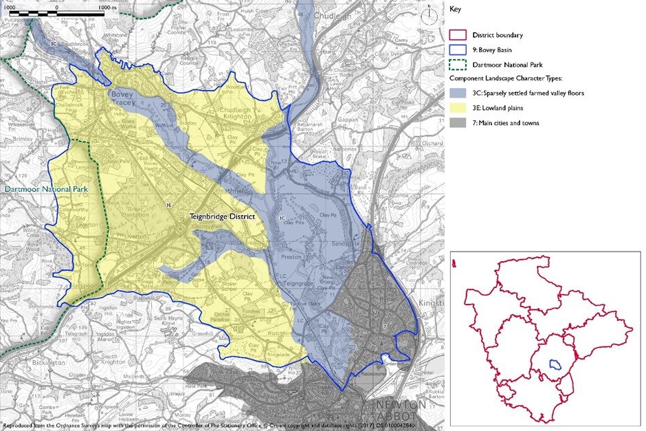
- Constituent Landscape Character Types
Constituent Landscape Character Types:
3C: Sparsely Settled Farmed Valley Floors, 3E: Lowland Plains
Part of National Character Area:
151: South Devon
GPS Coordinates: 285137, 72123
- Contextual Description
This area comprises a river basin containing the lower reaches of the River Bovey and middle reaches of the Teign. It extends from Bovey Tracey in the north-west to Newton Abbot in the south-east and is surrounded by rising land in adjacent areas. To the west the land rises noticeably to form the East Dartmoor Moorland Fringes and to the east the area is defined by spurs of higher land extending from the Haldon Ridge. To the north there is a more gradual transition to the Teign Valley and Slopes; while to the south there is a ridge of higher land which separates the basin from the Lemon valley within the Denbury and Kerswell Farmlands area.
Summary Description
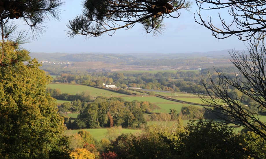
The Bovey Basin is a relatively small area, characterised by predominantly flat, broad alluvial floodplain enclosed by encircling hills and, importantly, by the influence of ball clay extraction activities. The quarrying activity has resulted in large areas of despoiled land including open cast quarries, spoil heaps (creating regular-shaped hills), settling lakes, and large modern industrial buildings. These features, along with road infrastructure and development, have altered the river basin character, giving rise to a fragmented and disturbed ambience in places. Nevertheless, there are remnant areas of irregular, mainly pastoral fields with hedgerows, woodlands and some important areas of acid heath, e.g. Bovey Heath and Chudleigh Knighton Heath, reflecting the presence of underlying sand and gravel. The tree-lined Rivers Bovey and Teign also provide a more naturalistic character amongst an otherwise complex, settled landscape; and the designed parkland of Stover Estate lends a sense of continuity within an area which has undergone considerable change. This is generally an inward-looking landscape due to the basin landform and the presence of notable areas of mixed and coniferous woodland, which provide a sense of enclosure.
- Distinctive Characteristics
- Underlying deposits of distinctive mineral-rich clays, silts and sands and gravels, the former of which continue to be extracted and are evident in the presence of spoil heaps in the landscape.
- Flat river basin, which encompasses the broad alluvial floodplain of the meandering Teign and Bovey Rivers, altered by extraction.
- Repetitive pattern of active, open-cast ball clay quarries, associated spoil pits, settling lakes and industrial buildings.
- Enclosed by high ground including Dartmoor, Highweek Hills and Haldon Ridge, with occasional views to these landmark features.
- Remnant areas of irregular, mainly pasture fields, areas of rough ground defined by hedgerows and meadows along the course of the rivers, creating a complex mix of land use patterns.
- Tree-lined rivers and small woodlands (some wet woods associated with abandoned quarries or river course).
- More extensive mixed and coniferous woodlands at Great Plantation and Stover Park Estate.
- Ecological interest including heathland areas which create colour and textural diversity, areas of wet grassland, woodlands along watercourses and marshes/ponds associated with former clay pits.
- Historic canal and railway reflecting the industrial heritage of the area; historic river bridges are a feature.
- Historic settlement pattern of farmsteads, hamlets and villages connected by narrow lanes and minor roads persists to the north and east.
- Modern housing and industrial developments which have notable urbanising influences at Chudleigh Knighton and on edges of Newton Abbot and Kingsteignton; industrial developments at Heathfield and Coldeast.
- Generally disturbed landscape with pockets of tranquillity in areas of woodland, heathland and pasture fields along the river courses.
- Major roads with associated development – A38 in particular.
Evaluation
- Special Qualities and Features
- Localised areas of scenic quality include Stover Park (designed landscape), heathlands, woodlands and wetlands, and the riverside landscapes of the Teign and Bovey, where sense of tranquillity may be strong.
- Areas of woodland and riparian landscape that provide an important setting for many settlements.
- The Rivers Bovey and Teign that provide wildlife havens and attractive tranquil riverside walks in an otherwise actively changing landscape.
- Remnant areas of heathland (CWSs and SSSIs) and acid grassland, wetlands and ponds and areas of mixed and broadleaved woodland associated with river corridors.
- Nationally significant Historic Park and Garden at Stover Park with extensive designed landscape.
- Other undesignated historic features associated with mineral extraction e.g. pottery, ponds and flooded clay pits, tin streamings or channels on Bovey Heathfield, the Stover Canal and mineral railway (Heathfield branch), historic river bridges and farmsteads make a particular contribution to this landscape’s sense of place.
Forces for Change and Their Landscape Implications
- Past and Current
- Considerable mineral extraction and landfill activities, with associated visual intrusion and fragmentation of landscape character and integrity.
- Expanding urban areas particularly associated with Chudleigh Knighton, Newton Abbot and Kingsteignton including leisure and retail development.
- Scattered residential development, industrial estates, main roads and power lines.
- Urban fringe activity including motorbike scrambling on rough ground, trespass, fly-tipping, advertising and unmanaged agricultural land.
- Extensive planting of conifer plantations in the twentieth century.
- Pressure for new solar farms and masts.
- Need for farms to have slurry tanks in response to new waste management regs – increasing industrialisation of farmsteads.
- Future
- Pressure for further expansion of mineral extraction activities, and need for clear restoration programmes.
- Potential restoration of worked out and abandoned quarries to provide landscape enhancements such as new areas of heath, woodland and wetlands.
- Potential for landfill or waste management sites in worked-out quarries and continuing land raising operations at Heathfield.
- Pressure for new residential developments at the edges of the main settlements, including on former mineral workings, which could lead to a further erosion of rural character.
- Potential expansion of existing industrial and commercial areas (particularly around Heathfield and Drumbridges), with loss of woodland and rural landscape character.
- Potential widening or other road improvements and associated roadside developments leading to further loss of tranquillity and erosion of character.
- Potential for new pylons and cables, which create visual clutter and do not respect existing landscape pattern and elements.
- Pressure for new leisure and recreational developments, which may further erode rural character and tranquillity.
- Continuing decline in traditional woodland management, threatening age and species diversity of semi-natural woodlands.
- More intense summer drought conditions as a result of climate change leading to a drying out of wetland habitats including riparian landscapes and meadows.
- The change /transition to the new land management system (ELMS) promises to be positive for the environment- more so than the CAP- and offers opportunity to strengthen landscape features and characteristics. Need for landfill/landraising within construction sites and modification of natural topography.
- Need for attenuation basins as part of SuDS as a requirement of new development.
Strategy
- Overall Strategy
To manage the valley basin character, particularly areas of remnant rural farmland, historic parkland, river corridor and heathland whilst planning to reduce the impacts of past and future extraction activities. Existing and new mineral extraction sites have progressive restoration plans with landscape enhancements. New built development (particularly that associated with existing settlements) assists in the restoration and enhancement of woodland, heaths, wetlands, fields and hedgerows and improvements to settlement landscape settings. Consideration is also given to the provision of appropriate recreational opportunities close to centres of population whist conserving special landscape qualities and features.
Guidelines
- Protect
- Protect and manage the woodland and wetland settings to existing settlements.
- Protect the integrity of remaining woods, heaths and wetlands, fields and hedgerows from damage by new development where feasible.
- Protect the condition and setting of historic structures associated with the river, the industrial heritage of the canal and railway corridor and the industrial heritage of the ball clay industry and canal and railway corridor.
- Protect historic parkland and features.
- Protect the Teign and Bovey corridors and other wetland habitats from inappropriate development and land uses which affect its natural flow.
- Protect the function of the floodplain by preventing further tipping within Flood Zone 3.
- Manage
- Manage the impacts of minerals and waste workings through the identification, safeguarding and management of woodland and other green infrastructure that fulfils the functions of screening, visual integration, filtering dust, and providing wildlife habitats and corridors.
- Manage existing conifer plantations for sustainable timber production and wildlife interest with a gradual transition to mixed and broadleaved woodland and the restoration of heathland.
- Manage existing areas of heath and encourage restoration of heathland to its historic sites where appropriate substrates will support it.
- Manage floodplain grassland through appropriate grazing and traditional and management regimes – both to enhance wildlife value and functions in flood prevention.
- Manage wet woodland, broadleaved woodland and hedgerows.
- Manage restoration of historic parkland and heritage features associated with river and industrial heritage.
- Manage areas of semi-natural habitat. Link and extend habitats where possible to increase biodiversity, contribute to nature recovery networks and provide suitable habitats for flora and fauna.
- Plan
- Plan for the use of local building materials within new developments.
- Plan for the restoration of minerals sites to respect and enhance the character and biodiversity of the area through sensitive ground modelling and re-vegetation with woodland, wetland, lowland heath and pasture.
- Seek improved habitat linkages and the creation of wildlife corridors through the use of green infrastructure in mineral development plans.
- Plan for new development to be well integrated into the surrounding landscape through the enhancement of woodlands, hedgerows and other features distinctive of the area.
- Plan for the restoration of floodplain pastures and marshland along the river corridors to allow natural river flooding and a dynamic, meandering river course.
- Plan to mitigate climate change impacts allowing natural process to take place where possible.
- Plan a landscape-led response to the UK-wide policy drive for increased tree and woodland planting, implementing Devon Local Nature Partnership’s ‘Right Place, Right Tree’ principles to create a balance of climate-resilient native species appropriate to the local landscape.
- Plan to contribute to nature recovery networks and provide suitable habitats for flora and fauna.
- Plan for the sensitive location of new development, avoiding locations visible from sensitive locations within 5km of Dartmoor National Park.
- Plan for new slurry tanks to be grouped with other farm buildings, recess into ground, use natural topography and trees for screening and integration and sensitive colour treatment with dark recessive colour to minimise visual impact.
- Plan for landfill/landraising of development sites and modification of natural topography by designing new landform in character with topographic context, avoid artificial engineered landforms, and integrate into the landscape.
- Plan for attenuation basins as part of SuDS required as part of development designing for biodiversity and amenity enhancement, where possible to enhance development not just provide engineering function.