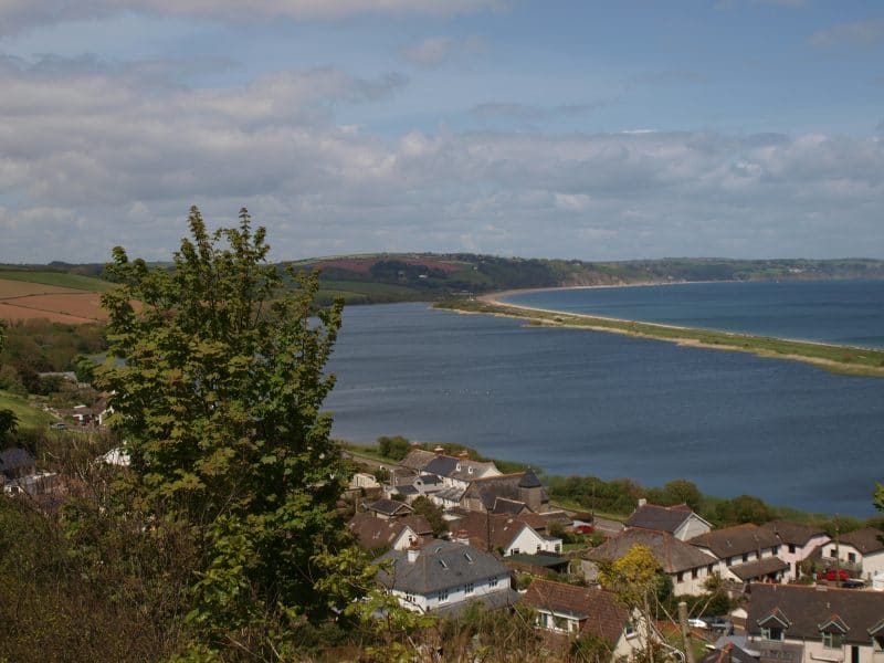
This landscape is distinctive for its long straight shingle beach which stretches between Torcross and Strete and the inland freshwater lagoon which sits behind. The low-lying coastal landscape is open with a strong horizontal emphasis and contrasts sharply with the dramatic high cliffs found further south. The cliffs to the north of the bay, which are included in this area, are lower and softer in profile than those found at Start Point. Behind the freshwater lagoon of Slapton Ley, is a gently rising plateau that recedes from the coast, reinforcing the sense of openness and space surrounding the bay. The coastal combes that are set within the inland plateau are relatively broad and open and have a settled character – historic nucleated villages being common. The valleys each contain a small stream associated with wet woodland and wet grassland; and the field pattern is small to medium scale and irregular, lending a sheltered character. On the plateau landscape between the valleys farming is mixed, with medium-sized regular fields defined by Devon hedgebanks. Here woodland is sparse although woodland clumps and hedgerow trees often give rise to a tree lined horizon.
- Context
This area comprises the low, wide sweeping bay of Start Bay and the cliffs to the north along with the coastal combes which extend far inland, dissecting the rising inland plateau landscape. To the east this landscape is bordered by the sea, while to the south there is a transition as the geology changes and the land rises onto the Start Point Coastal Plateau. To the west and north the edge of this area is marked by a watershed beyond which the deeply incised rivers feed into the distinctive estuary of the Dart and valley of the River Avon.
- Constituent Landscape Character Types
Constituent LCTs: 4B: Marine Levels, 3B: Lower Rolling Farmed and Settled Valley Slopes, 5A: Inland Elevated Undulating Plateau, 4D: Coastal Slopes and Combes Part of NCA: 151: South Devon - Distinctive Characteristics
- Elevated land with a rolling topography underlain by Meadfoot Beds dropping gently to the coast with its distinctive open shingle bay.
- Inland plateau that slopes eastwards towards the sea and is drained by series of small steams creating shallow combes.
- Higher ground sparsely wooded with grown-out wind-sculpted beech hedgebanks and some pine shelterbelts.
- Small woodland copses on valley sides, often emphasising landform; tree-lined streams and wet woodlands common in valleys and combes.
- Mixture of regular modern and Parliamentary fields of small to medium scale, with smaller curving fields of medieval origin remaining on valley slopes.
- Mixed farming on plateau and areas of pasture on steeper slopes within valleys.
- Extensive freshwater lake, swamp and coastal grassland and scrub habitats; farmland with bird interest; ancient semi-natural and broadleaved woodlands; and areas of neutral grassland and wet woodland fringing streams.
- Iron Age hillfort, castle and Civil War features on promontories and elevated locations in commanding positions; ancient settlement remains also lend strong time-depth.
- Historic villages clustered at road crossings and bridging points; often centred on a square-towered church; farmsteads scattered throughout, nestled in dips with shelterbelts.
- Strong local vernacular of stone buildings with slate roofs and red brick detailing, with some cream cob/ render cottages, often thatched.
- Strong overarching perceptions of tranquillity and remoteness in many areas.
Evaluation
- Special Qualities and Features:
- High scenic quality reflected in the inclusion of coastal areas and the Gara valley and combe in the South Devon AONB.
- Outstanding open views along the length of Slapton Sands – sometimes bleak depending on weather conditions – and notable views out to sea with large skies.
- Sense of isolation, remoteness, enhanced by natural qualities of the coast; tranquillity that is higher than many other coastal areas of South Devon.
- Slapton Ley – largest natural freshwater lagoon in south-west England and important habitat for migratory and wintering birds – SSSI and NNR
- Slapton Sands associated with Second World War – used to practice the D-Day landings, now commemorated by a Torcross Tank which sits at the southern end of the beach.
Forces for Change and Their Landscape Implications:
- Past and Current
- Linear development along the A379 undermining the distinctive identity of villages, namely Torcross, Stokenham and Chillington.
- Growth of historic villages resulting in loss of nucleated form and character e.g. Stoke Fleming.
- Growth of tourism and recreation resulting in development of car parks, caravan and camping sites, interpretation and signage.
- Loss of field boundaries particularly on upland plateau due to close cutting of hedgerows, altering field patterns and scale.
- Future
- Uncertainty over future levels of agricultural grants and funding, potentially resulting in traditional farming methods such as strip fields and use of ‘marginal’ land such as grazing marsh becoming unviable.
- Potential sea level rise, with impacts on coastal habitats and loss of agricultural land.
- Loss of fresh water lagoons, resulting from higher sea levels and greater wave energy due to increased frequency and intensity of storms; changes may also occur in the volumes of sand being deposited.
- Changes in species composition as a result of alterations to growing seasons and the introduction of new species, pests and diseases.
- Potential development pressures associated with villages (e.g. Chillington) and nearby urban areas, notably Dartmouth.
- Continued demand for recreation facilities, changing the character of the area.
- Demand for renewable energy sources, including tidal schemes, offshore and onshore wind, all potentially affecting the character of the area.
Strategy
- Overall Strategy:
To protect the high scenic quality associated with the South Devon AONB, and to sustain the area’s important nature conservation sites, and historic settlement. The shingle beach, and freshwater lagoon are well managed and their resilience to climate change is enhanced where feasible. Recreation is encouraged, but a good balance between recreation and conservation is retained. The wider plateau landscape and gentle combes are actively managed and hedgebanks sensitively protected and repaired. Development of villages and nearby urban areas, notably Dartmouth, is sensitively designed and sited to minimise its intrusion and to protect historic character and form of settlement.
Guidelines:
- Protect
- Protect the open character of the inland plateau and Slapton Sands and views to and along the coast and sea.
- Protect the undeveloped character of Slapton Bay (beach, and freshwater lagoon and surrounding combes and hills) ensuring that any limited new development in the area respects the scale and horizontal emphasis of the landscape.
- Protect the settlement pattern of nucleated villages, hamlets, farms and houses.
- Manage
- Manage the internationally-important habitats including shingle ridge, saltmarshes, freshwater lagoon, using traditional techniques including appropriate levels of grazing.
- Manage existing small woodland copses and encourage the planting of new copses on valley sides where they emphasise landform.
- Manage agricultural land fringing the bay, encouraging farmers and commoners to use the pastures and marshes for appropriate levels of grazing as part of their farming systems.
- Manage fertilizer run-off from adjacent areas to ensure no contamination of nature conservation sites.
- Manage hedgerows to reinforce the sense of a well-managed landscape.
- Continue to provide habitat for farmland birds by supporting wildlife-friendly mixed farming systems
- Manage recreational use of the area to ensure that the correct balance between recreation and conservation interests is retained
- Provide sensitive interpretation where appropriate to increase the public’s awareness of the association with the D-Day landings, important habitats and changing landscape.
- Plan
- Plan for future impacts of climate change (particularly the effects of sea level rise and coastal erosion), allowing natural process to take place where possible, whilst ensuring that local communities are involved in making decisions about their future landscape.
- Plan for opportunities to expand wetland habitats to build resilience to future climate change.
- Plan for the future expansion of towns on the fringes, incorporating new development into its landscape setting, and providing green infrastructure links to routes such as the South West Coast Path.
- Plan to reduce light pollution from Dartmouth.