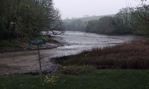
This is a waterside landscape where open water is juxtaposed with steep wooded valley sides that rise to rounded ridges between valleys and creeks. The creeks branch off the main waterway to form intricate tidal waterways which are best explored by boat and have a quiet and secretive character. The farmland on the rounded ridges above is divided by hedge banks that emphasise the convex slopes of the land. The tidal character of this area results in a continually changing scene that varies from open expanses of water to shiny mudflats, and the area as a whole has a coastal character – exposed to salt laden winds, with the sounds of seabirds being strongly evocative. Views across and up and down the estuary are a defining feature, although they may be tantalisingly fleeting.
- Context
This area is defined by the Kingsbridge Estuary – a ria valley (drowned river valley) with tidal creeks and tributaries that extend far inland. Its boundaries are defined by surrounding higher land creating a distinct visual unit or ‘bowl’ focused on the estuary. To the north the area is flanked by the higher Mid Avon and West Dart Valleys and Ridges while to the south the coastal plateau landscapes enclose the mouth of the ria and wrap around to the east and west.
- Constituent Landscape Character Types
Constituent LCTs: 4A: Estuaries, 3G: River Valley Slopes and Combes, 5A: Inland Elevated Undulating Plateau, 3B: Lower Rolling Farmed and Settled Valley Slopes, 3A: Upper Farmed and Wooded Valley Slopes, 1B: Open Coastal Plateau Part of NCA: 151: South Devon - Distinctive Characteristics
- Narrow entrance to estuary emphasised by cliffs of the coastal plateau; estuary then broadens into a wider expanse of water reflecting the softer geology of the Meadfoot Group.
- North-south ria with large expanses of inland tidal water and east-west, narrow, steep-sided tributary creeks and stream valleys which penetrate far inland.
- Estuary flanked by pronounced, steep sided rounded hills that have a clear visual and topographic association with the estuary and are exposed to salt-laden winds.
- Well wooded estuary and creeks, often with ancient semi-natural ‘hanging’ oak woodlands which descend to the water’s edge; parkland landscapes and trees add to the character of the valley sides.
- Mixed cultivation, mainly pasture, in fields with curving hedges; variable presence of hedgerow trees.
- Large expanses of inland tidal water and mudflats and tidal marsh that contrast with open rounded skylines broken by distinctive, landmark church towers associated with ridge top settlements.
- Strong maritime traditions, visible today in fishing and recreational craft but also in architecture in Kingsbridge, where merchant seafarers’ properties reflect area’s former strategic importance for trade.
- Stone bridges across the upper arms of the creeks and old mill buildings that also add interest.
- Historic settlements of Kingsbridge at the head of the estuary and Salcombe at the mouth.
- Other smaller settlements located at the head of the small creeks (Frogmore and South Pool) or standing proud on ridges of higher land (West Alvington and Churchstow); elsewhere dispersed pattern of farmsteads.
- Dense network of lanes including green lanes but many parts of estuary are inaccessible by car.
Evaluation
- Special Qualities and Features:
- Mostly within the South Devon AONB, recognised for its high scenic quality; the coast is also designated Heritage Coast.
- Views across and up and down and across the estuary where the juxtaposition of water and land can be appreciated are distinctive.
- Strong sense of place derived from open water and steep sided hanging woodlands, rounded slopes and dominant maritime influences.
- Internationally-important maritime and intertidal habitats including the Salcombe and Kingsbridge Estuary SSSI and extensive areas of CWS including mixed farmland with bird interest.
- Area valued for water based recreation and secretive quality of the tidal creeks for its limited access except by boat.
- Long maritime history reflected in quayside development and buildings many of which are listed.
- Various SMs e.g. site of medieval settlement at Ilton Cross and concentration of bowl barrows around West Charleton.
- Salcombe association with Tennyson’s poem ‘Crossing the Bar’ while John Walcott (satirist and poet) was born and educated in Kingsbridge.
Forces for Change and Their Landscape Implications:
- Past and Current
- Declining fishing industry but some resurgence with sustainable scallop fishery area established in Salcombe Harbour.
- Recent shift from commercial boats to recreational craft; recreational boating now a prominent feature.
- Series of flood events since 2004 during extreme spring high tides, strong easterly winds and inland rainfall, affecting the lowest areas of Kingsbridge and Salcombe,
- Gradual displacement of established maritime businesses from their traditional premises, undermining viability of essential shore-side support services and increasing pressure on undeveloped estuary-side locations to accommodate boating uses.
- Growth of main settlements (Kingsbridge and Salcombe) onto higher land, becoming more visually prominent from surrounding landscape and from the water.
- Erosion of coastal edges due to pressure for access and water-borne recreation.
- Loss of woodland due to lack of management.
- Development of masts which conflict with historic church tower landmarks and alter the uncluttered rounded skyline which defines the estuary.
- Conversion of traditional agricultural buildings and attached land for domestic and leisure uses with associated unsympathetic boundary and surfacing treatments.
- Future
- Uncertainty over future of agricultural grants and subsidies, potentially affecting farm viability and the management of characteristic landscape features such as hedgerows and woodlands; changes in grants also threaten the viability and continuation of mixed farming.
- More extreme storm events and sea level rise with potential major impact on estuary infrastructure and settlement at certain locations.
- “Habitat squeeze’ due to lack of space to accommodate retreat of habitats against the hard built environment.
- Significant pressure for further built development along estuary shorelines, with cumulative impacts on landscape, habitats and water quality.
- Huge demand for moorings and marina spaces and pressure on key access points, port waste management and water-based recreational areas.
- New requirements for shoreside infrastructure for the fishing sector and better launch facilities for small recreational craft.
- A rapidly increasing level of ownership of canoes, kayaks and trailered power recreational craft, which presents new management challenges for the safe and sustainable use of estuaries.
- Increasing population and demand for public access to and around the estuary, and proposed coastal access provisions, potentially increasing disturbance of sensitive wildlife.
- Potential pressure for the tidal energy of the estuary to be harnessed as a renewable energy source in response to government targets.
Strategy
- Overall Strategy:
To protect views across the open water of the estuary and coast to the surrounding rounded unfettered skylines; and to protect the area’s valued maritime character and outstanding scenic quality. Historic settlement pattern and vernacular character are reinforced in new development with church towers remaining as uncompromised landmarks. The pattern of fields, woodlands, hedgerows and narrow lanes is managed and enhanced. Recreation, particularly water based recreation, is carefully monitored and managed and the natural and cultural heritage of the estuary is conveyed through sensitive interpretation. Local communities are involved in planning for future landscape change as a result of sea level rise and change in coastal erosion.
Guidelines:
- Protect
- Protect the distinctive, unspoilt, and exposed skylines which define the estuary.
- Conserve the open, expansive views across the estuary, and the area’s coastal and sea views.
- Protect the landscape’s sense of tranquillity and unspoilt character and particularly the secluded character of the tributary creeks from excessive water-based recreation.
- Protect the traditional maritime uses within existing harbour areas and avoid loss of essential boat maintenance and storage infrastructure.
- Protect traditional building styles and materials, utilising the same styles and materials in new development wherever possible (whilst seeking to incorporate sustainable design).
- Protect the settlement pattern of nucleated villages, hamlets, farms and houses.
- Protect the landscape setting of Kingsbridge and Salcombe, ensuring new development enhances and restores features such as hedgerows and woodlands.
- Protect the landscape’s network of quiet lanes enclosed by woodland and species-rich hedgebanks, resisting unsympathetic highways improvements or signage.
- Manage
- Manage the hedgerow network by encouraging traditional hedgerow management practices and restoration of lost or gappy hedgerows sections particularly along steep slopes to maintain distinctive field patterns and minimise soil erosion and reduce diffuse pollution.
- Manage and re-link broadleaved ‘hanging’ woodlands encouraging the use of traditional techniques such as coppicing, and retaining the diversity of woodland types within the area.
- Manage estuarine and coastal habitats, including intertidal habitats, maritime grassland.
- Continue to provide habitat for farmland birds by supporting wildlife-friendly mixed farming systems
- Manage the landscape’s popularity for recreation – encourage the use of existing facilities whilst providing sustainable transport options and green infrastructure links to the surrounding settlements and avoid the spread of moorings and built development into currently undeveloped parts of the estuary.
- Plan
- Plan for the expansion of nearby settlement incorporating new development into its landscape setting and providing green infrastructure links to recreational routes.
- Plan to enhance and restore rural character and tranquillity through careful siting of any new development avoiding prominent locations such as valley sides and shoreline, with enhancement of hedgerows, woodlands and roadside planting to major road corridors.
- Plan for sensitive, appropriate recreational and leisure infrastructure which fits the landscape setting; and provide interpretation on the ever-changing nature of the landscape and its significance.
- Plan to control moorings and water-based activities to maintain tranquillity and regulate timing and zoning of non-peaceful water-based activities to minimise impact.
•Plan for sensitive design of surfacing, way marking and signage of footpaths in and around the estuary to maintain rural character and avoid or reduce soil erosion. - Plan for the climate change adaptation, particularly in relation to sea level rise and coastal erosion, balancing the need for coastal defences against the benefits of allowing natural processes to occur; ensure local communities are involved in decision-making.
- Plan for expansion of estuarine habitats where feasible to build resilience to future climate change.