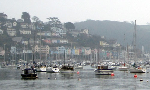
This landscape is centred on the Dart estuary which carves a deep fissure into the surrounding higher land, creating a unique amalgam of land and water. A journey down the estuary displays many contrasts, from steep, wooded cliffs to gentle, rolling pasture lands, and from the grandeur of the wide and deep main channel to the intimacy of the tributary creeks. The tributary creeks have cut their own steep sided, secluded valleys such as Bow Creek, Dittisham Mill Creek and Old Mill Creek, deeply dissecting the high ground. The steeply sloping banks and valley sides, in places too steep for agriculture, support some of the most extensive tracts of ancient semi-natural woodland in the South Devon AONB and these woodlands enhance this landscape’s sense of enclosure. Small historic villages cling to the steep slopes, their vernacular buildings, boathouses and mills sitting on the water’s edge; and this coupled with the network of narrow ancient lanes, lends a timeless quality to the area.
- Context
 This area comprises the Dart Estuary – a ria valley (drowned river valley) with tidal creeks that extend as far as Totnes (a distance of 17km). Its boundaries are defined by surrounding higher land creating a distinct visual unit focused on the estuary. To the north beyond this landscape the land drops northwards to form Torbay Hinterland while to the east the land forms a coastal plateau (the Froward Point to Berry Head Coastal Plateau) which faces out to sea. To the south and west the tributary creeks of the estuary become inland valleys creating deep incisions into the inland plateau landscapes.
 - Constituent Landscape Character Types
Constituent LCTs: 4A: Estuaries, 3B: Lower Rolling Farmed and Settled Valley Slopes, 3G: River Valley Slopes and Combes, 5A: Inland Elevated Undulating Land Part of NCA: 151: South Devon - Distinctive Characteristics
- Deeply incised estuary which cuts into surrounding plateau landscape, through the Meadfoot Beds and Staddon grits in its middle reaches and the harder mica and quartz schists further inland.
- Main estuary channel that is widest at its mouth, quickly becoming narrow and tightly defined, particularly in the tributary creeks.
- Higher ground sparsely wooded with grown-out wind-sculpted beech hedgebanks and some pine shelterbelts.
- Valley sides that are densely wooded with ancient oak, ash and hazel woodland, particularly where north facing and less suited to agriculture.
- Traditional apple and plum orchards in some locations.
- Mixture of regular modern and Parliamentary fields of small to medium scale on the upper slopes with smaller curving fields on the steep estuary slopes.
- Mixed farming systems with small fields and pasture on valley sides too steep for arable, including species-rich grasslands supporting farmland bird populations and arable plant communities.
- Historic parkland affording delightful views of the estuary and the historic mills along the tributary creeks (reflecting previous prosperity and economy based on corn and paper).
- Clustered hamlets and villages clinging to steep sides of tributary creeks; larger settlements of Dartmouth and Kingswear on steep slopes and land reclaimed from the estuary; farmsteads scattered throughout, nestled in dips with beech shelterbelts.
- Vernacular stone buildings with slate roofs, with some cream cob/ render cottages, often thatched.
- Strong overarching perceptions of tranquillity and remoteness in many areas.
Evaluation
- Special Qualities and Features:
- Longest and scenically most spectacular of estuaries in South Devon; part of the South Devon AONB.
- One of the deepest natural harbours in South Devon, used for both commercial and naval shipping.
- Most extensive tracts of ancient semi-natural woodland in the South Devon AONB – designated SSSI.
- High degree of remoteness due to general inaccessibility of area by land and narrow winding lanes.
- Historic Park and Gardens of Sharpham (Grade II*) and Greenway (Grade II), the latter of national significance for the lichens on parkland trees.
- Conservation Areas at Stoke Gabriel, Diddisham, Dartmouth and Kingswear.
- Many SM including bowl barrows, Greenway hillfort and D-Day landing craft maintenance sites along the edge of the Dart Estuary.
- Highly valued for water-based creation.
- Cultural associations with Agatha Christie (Greenway house and gardens) and Britannia Royal Naval College which is a local landmark.
Forces for Change and Their Landscape Implications:
- Past and Current
- Intensification of agriculture, resulting in increase in arable land and loss of hedgerows as well as changes to the pattern of farm units.
- Expansion of villages e.g. Stoke Gabriel resulting in loss of historic form and character.
- Loss of traditional orchards due to lack of management and dead or dying trees.
- Decline of importance of Dartmouth’s port after Second World War following damage by bombing and changes in the shipbuilding industry.
- Increased popularity of area for water-based recreation and as a holiday destination.
- Future
- More extreme storm events and sea level rise, likely to affect estuary infrastructure and settlements at certain locations, as well as key habitats, “habitat squeeze” being a particular issue due to lack of space to accommodate habitat retreat.
- Significant pressure for further built development along estuary shorelines, with cumulative impacts on landscape, habitats and water quality.
- Huge demand for moorings and marina spaces and pressure on key access points, port waste management and water-based recreational areas.
- New requirements for shoreside infrastructure for the fishing sector and better launch facilities for small recreational craft.
- A rapidly increasing level of ownership of canoes, kayaks and trailered power recreational craft, presenting new management challenges for the safe and sustainable use of estuaries.
- Increasing population and demand for public access to and around the estuary, and proposed coastal access provisions, potentially increasing disturbance of sensitive wildlife.
- Potential pressure for the tidal energy of the estuary to be harnessed as a renewable energy source in response to government targets.
- Uncertainty over future agri-environment scheme funding, posing a threat to conservation of wildlife and landscape features.
- New markets for wood as a fuel resulting in changes to woodland management.
Strategy
- Overall Strategy:
To protect the area’s outstanding scenic quality and valued maritime character, including views across the open waters of the estuary to surrounding unfettered skylines. Historic settlement patterns and vernacular character are reinforced in new development and the pattern of fields, woodlands, hedgerows, parkland and narrow lanes is managed and enhanced. Recreation, particularly water-based recreation, is carefully monitored and managed and the natural and cultural heritage of the estuary is conveyed through sensitive interpretation. Local communities are involved in planning for future landscape change as a result of sea level rise and change in coastal erosion.
Guidelines:
- Protect
- Protect the distinctive, unspoilt, and exposed skylines which define the estuary.
- Conserve the open, expansive views across the estuary, and the area’s coastal and sea views.
- Protect the landscape’s sense of tranquillity and unspoiled character – particularly the secluded character of the tributary creeks – from excessive water-based recreation.
- Protect the traditional maritime uses within existing developed harbour areas and avoid loss of essential boat maintenance and storage infrastructure.
- Protect the character and setting of the area’s historic parkland, ensuring any new development does not encroach into these historic landscapes or views to and from them.
- Protect traditional building styles and materials, utilising the same styles and materials in new development wherever possible (whilst seeking to incorporate sustainable design).
- Protect and restore historic features associated with maritime history particularly the estuary’s industrial heritage such as mills and boatyards.
- Protect the settlement pattern of nucleated villages, hamlets, farms and houses.
- Protect the landscape settings of Dartmouth and Totnes, ensuring new development enhances and restores features such as hedgerows and woodlands.
- Protect the landscape’s network of quiet lanes enclosed by woodland and species-rich hedgebanks, resisting unsympathetic highways improvements or signage.
- Manage
- Manage the hedgerow network by encouraging traditional hedgerow management practices and restoration of lost or gappy hedgerows sections particularly along steep slopes to minimise soil erosion and reduce diffuse pollution.
- Manage and re-link broadleaved ‘hanging’ woodlands encouraging the use of traditional techniques such as coppicing, and retaining the diversity of woodland types within the area; explore opportunities for community utilisation of coppice residues as a low-carbon fuel source.
- Manage estuarine and coastal habitats, including intertidal habitats and maritime grasslands.
- Continue to provide habitat for farmland birds by supporting wildlife-friendly mixed farming.
- Manage the landscape’s popularity for recreation, encouraging the use of existing facilities whilst providing sustainable transport options and green infrastructure links to the surrounding settlements; avoid the spread of moorings and built development into currently undeveloped parts of the estuary.
- Manage parklands to provide a continual supply of veteran tree habitat for wildlife and to retain the distinctive parkland character.
- Plan
- Plan to enhance and restore rural character and tranquillity through sensitive siting of any new development, avoiding prominent locations such as valley sides and shoreline, and enhancing hedgerows, woodlands and roadside planting to major road corridors.
- Restore and manage areas of relict traditional orchards and explore opportunities for the creation of new ones, including community orchards to promote local food and drink production.
- Plan for recreation infrastructure which is appropriate to the landscape setting and provide interpretation on the ever-changing nature of the landscape and its significance.
- Plan for sensitive design of surfacing, way marking and signage of footpaths in and around the estuary to maintain rural character and avoid/reduce soil erosion.
- Plan to control moorings and water-based activities to maintain tranquillity and regulate timing and zoning of non-peaceful water-based activities to minimise impact.
- Plan for the future impacts of climate change, particularly sea level rise and coastal erosion, balancing need for coastal protection against benefits of allowing natural processes to take place wherever possible; ensure local communities are involved in decision-making.
- Plan for expansion of estuarine habitats where feasible to build resilience to future climate change.