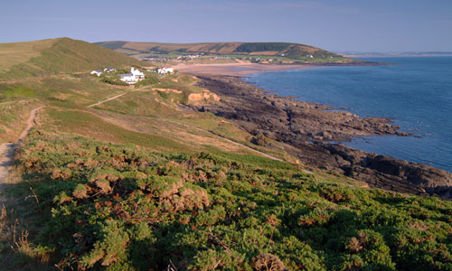
This is a landscape of contrasts, dominated by its seascape. There are wide westerly views to the sea, with the long, low outline of Lundy visible on the horizon, and views across Bideford Bay as far as Hartland Point. A series of rolling downland ridges run on to long headlands interspersed with sandy beaches. The smooth downland has an elevated, open, character, whilst the rough headlands feel wild, remote and windswept. The beaches are crowded with holidaymakers in summer, but in winter they feel empty and desolate. This is a colourful landscape – green fields; golden sands; vivid purple and yellow heath; brown and grey rocks; and glorious sunsets – but its mood is always set by the ever-changing sea.
- Context
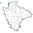
 This is a fairly small area comprising the westward-facing coast between Saunton Down and Morte Point. To the north is a gradual transition to the North Devon High Coast (where the downland landform is less dominant and there is more woodland) and to the east is another gradual transition to the North Devon Downs. This transition is marked by a gradual reduction in the influence of the sea. To the south is the flat, estuarine landscape of the Taw-Torridge Estuary.
 - Constituent Landscape Character Types
Constituent LCTs: 2C: Steep Open Slopes, 4C: Coastal Slopes and Combes With Settlement, 4E: Extensive Inter-Tidal Sands, 4F: Dunes, 4H: Cliffs, 5C: Downland Part of NCA: 145: Exmoor - Distinctive Characteristics
- Northern part of area underlain by fossil-rich Devonian Morte Slates, and the southern part by Devonian red and brown sandstone.
- Topography forming a repeating pattern of smooth-profiled downland ridges with steep side slopes, running east-west.
- Ridges running into long headlands (Morte Point, Baggy Point and Saunton Down) with smooth upper profiles and rocky sides descending to rugged shorelines.
- Headlands sheltering a series of sandy beaches, including Woolacombe Sands which is 3km long, with a dune system on its landward side.
- Occasional spring-fed streams flowing through relatively steep valleys to the sea.
- An open, expansive landscape with few trees and smooth horizons; trees largely limited to occasional wind-sculpted pines, and patches of scrub; tree Clump at Oxford Cross (originally planted by Henry Williamson) is a distinctive feature.
- Agriculture predominantly pastoral (sheep grazing), with arable on sheltered sites and further inland.
- Smaller fields divided by hedges or hedgebanks (often faced with local Morte slates) on lower land, but larger, more open and regular fields on higher land.
- Important ecological mosaic of coastal heath, maritime cliff and foreshore habitats, supporting valuable and diverse populations of birds, insects, reptiles, plants, ferns and lichens.
- Active dune systems at Croyde and Woolacombe Warren supporting a wide variety of plants; further inland, unimproved grassland that supports grass, herb, butterfly and bird species.
- Historic landscape features include 14th century cultivation terraces above Saunton, and historic field patterns around Croyde, Mortehoe and Georgeham, where hedges or stone-faced banks divide former open fields into enclosed narrow strips.
- Second World War lookout post on the cliffs near Putsborough, and a chain of ‘dummy pillboxes’ along Baggy Point, used by the Allies for D-Day training.
- Scattered farms and picturesque historic villages (e.g. Mortehoe, Croyde and Georgeham), often in sheltered combes.
- Locally-distinctive traditional buildings with cob, thatch and hung slates (the latter particularly in exposed locations).
- Victorian linear expansion of settlements such as Woolacombe and Croyde for tourism, as well as modern caravan parks on hillsides.
- Lundy Island’s distinctive long, low profile on the horizon is a distinctive feature of the seascape.
Evaluation
- Special Qualities and Features:
- Area of very high scenic quality, within the North Devon Coast AONB, with amazing coastal views and seascapes encompassing magnificent beaches and dramatic cliffs with high levels of tranquillity.
- Important maritime and coastal habitats including Saunton to Baggy Point Coast SSSI (cliffs, foreshore and small active dune system) and Morte Point SSSI (extensive area of sea cliff and foreshore (supporting nesting seabirds including fulmar, cormorant and shag), coastal heath and grassland).
- Many CWSs including sand dune system at Woolacombe Warren and unimproved grassland.
- Exposed geological features (including the remains of a fossilised fish preserved within bands of volcanic ash and shale) designated as SSSIs or RIGSs.
- Several protected wreck sites lying off the coast.
- Numerous listed buildings, including manor houses, farms and the white painted Saunton Sands Hotel which is an example of the Art Deco style.
- Conservation Areas in Croyde, Georgeham, Putsborough Woolacombe and Mortehoe village centres.
- Saunton Court (designed by Gertrude Jekyll) listed on the Register of Historic Parks and Gardens.
- Literary associations with Henry Williamson, who wrote Tarka the Otter whilst living in Georgeham.
- Large areas of land owned by the National Trust, including the Croyde Estate (Baggy Point) and part of the Mortehoe Estate (from Woolacombe Down to Morte Point).
- Extensive access land along the coast and South West Coast Path following the cliff edges.
- A popular holiday destination, with beaches packed with visitors in the summer and attractions including the National Sandcastle Competition, and surfing events.
Forces for Change and Their Landscape Implications:
- Past and Current
- Tourism-related development impacting on views, with poorly-sited and designed caravan sites, camp sites and car parks prominent features within the landscape.
- Pressure from new tourism development within the undeveloped coast (e.g. new hotel construction) and an increase in the number and extent of permanent structures within existing holiday parks.
- High volumes of traffic reducing the tranquillity of the area.
- Telecoms Masts (including those on Saunton Down) interrupting the smooth profile of the downland.
- Light pollution from larger towns to the south affecting starlit skies.
- Intrusion of built development in settlements such as Westward Ho! into views southwards across the Taw-Torridge Estuary.
- Damage to coastal heath and dune systems as a result of trampling and visitor pressure.
- Intensification of agriculture resulting in loss of hedgerows/ hedgebanks, agricultural improvement of grassland and conversion of pasture to arable production, changing the character of the landscape.
- Poor maintenance of stone-faced hedgebanks, resulting in their gradual loss from the landscape.
- Loss of species-rich coastal grassland and heath to scrub and bracken through changes in grazing practices and abandonment of marginal land (e.g., coastal cliff slopes),
- Consented wind farm at Fullabrook Down, which will be visible from this area.
- Future
- Further growth in the popularity of the area for tourism and recreation, eroding high levels of tranquillity, and leading to increased demand for facilities and public access.
- Changes in species composition of grassland and heathland habitats as a result of alterations in seasonal patterns, and new pests and diseases resulting from climate change.
- Increased coastal erosion as a result of rising sea levels, and increased strength and frequency of storms, which could result in the loss of beach and dune systems, and ‘coastal squeeze’ of habitats between the eroding shoreline and agricultural land behind (Shoreline Management Plan for this stretch of coastline recommends ‘no active intervention’).
- Beach and dune systems susceptible to changes in the water table.
- Continued demand for renewable energy schemes, including tidal and wave power, offshore and onshore wind turbines (including the proposed Atlantic Array), plus smaller-scale domestic schemes with a cumulative landscape impact.
- Changes in agricultural subsidies and demand for food security affecting agricultural practices and declining management of marginal land, particularly outside SSSI areas.
Strategy
- Overall Strategy:
To protect the high scenic quality of the landscape and seascape, minimising the impacts of tourism development, and maintaining its valuable biodiversity. The area’s contrasting landscapes, and its undeveloped character are protected and enhanced. Sustainable agriculture is encouraged, along with good management of semi-natural habitats and historic landscape features. Visitors are encouraged to enjoy the landscape, and a good balance between tourism and conservation interests is achieved.
Guidelines:
- Protect
- Protect the area’s distinctive seascapes.
- Protect the open character of the area and its long-ranging views, resisting the further linear spread of tourist development out from settlements.
- Protect the smooth profiles of open downland which form the backdrop to the area, ensuring new development avoids the most prominent open skylines.
- Protect historic landscape features such as cultivation terraces and historic field patterns, repairing gaps in hedgebanks using traditional local techniques.
- Protect historic settlements from unsympathetic expansion.
- Protect traditional building styles and materials, particularly cob, Morte slate, thatch, whitewash and stone; ensure that any new development is sympathetic in terms of style and location, whilst incorporating sustainable design.
- Protect the character of the local lanes, resisting intrusive signage and unsympathetic highways improvements.
- Protect and manage the historic gardens at Saunton Court, replacing mature specimen trees when necessary.
- Manage
- Manage, extend and re-link the diverse range of coastal habitats to enhance their biodiversity, and increase their resilience to climate change.
- Increase the areas of coastal heathland on Woolacombe Down, Saunton Down and Baggy Point, and create buffer zones between cliff communities and improved agricultural land where possible.
- Manage agricultural land and sustain agricultural use, encouraging farmers to repair features such as hedgerows and hedgebanks, and to graze ‘marginal’ areas such as coastal grassland and heath as integral parts of their farming systems.
- Manage active sand dune systems through appropriate levels of grazing and access.
- Manage visitor pressure to minimise damage to fragile habitats, and achieve an acceptable balance between conservation and recreational interests.
- Manage land within the North Devon Coast AONB and North Devon Biosphere Reserve in accordance with the AONB’s statutory duties and the guidelines of the Biosphere Reserve.
- Plan
- Plan to reduce the visual impact of tourist facilities such as caravan parks.
- Plan to mitigate climate change effects, particularly coastal squeeze, by seeking to expand semi-natural habitats and wildlife networks.
- Plan for sensitive tourism and recreation activity, seeking to link and create access routes with the aim of encouraging exploration of inland landscapes and taking pressure off the coast.
- Plan alternative sustainable transport systems to reduce the number of cars on the area’s roads.