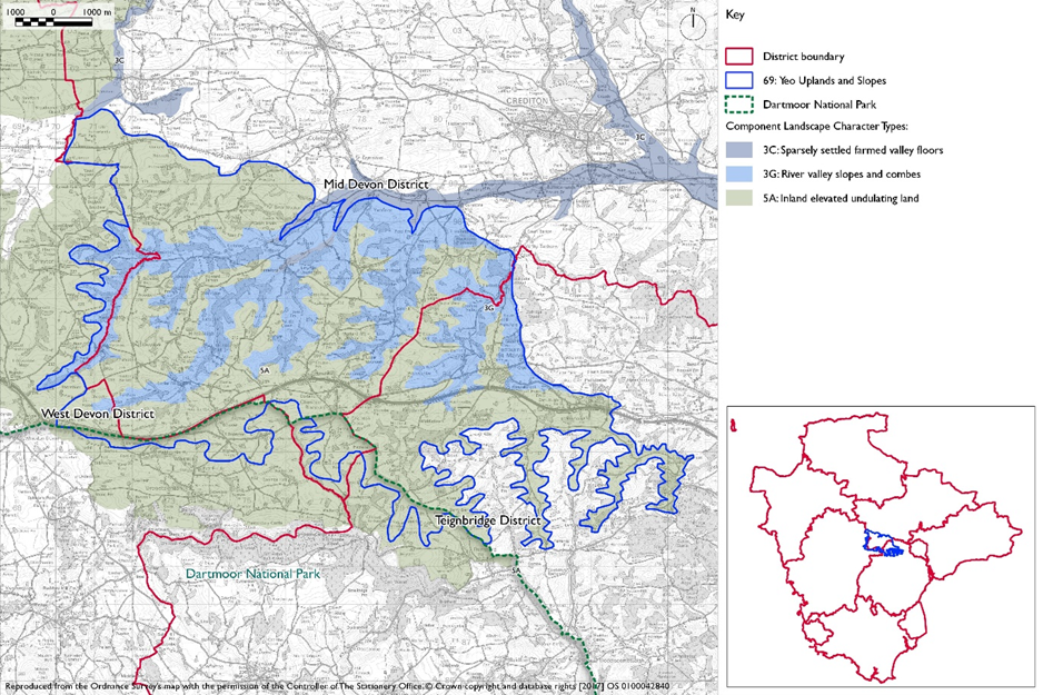
- Constituent Landscape Character Types
5A: Inland Elevated Undulating Land
3G: River Valley Slopes and CombesPart of National Character Area:
149: The Culm
- Contextual Description
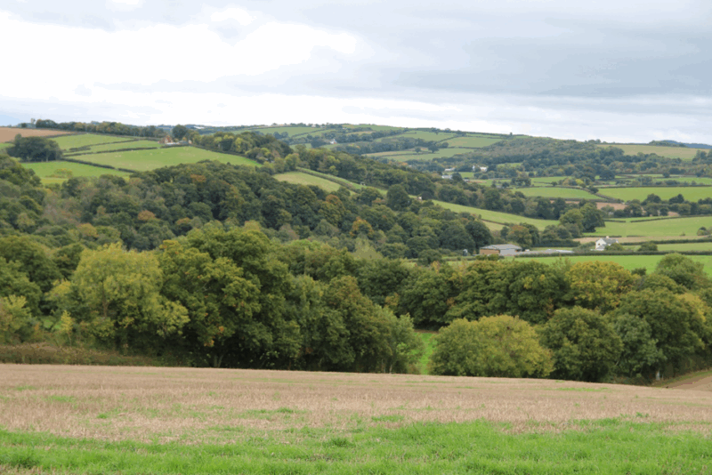
This is a rolling upland landscape, which sits above surrounding areas offering spectacular and extensive views into adjacent landscapes, including the Yeo, Culm and Exe Lowlands, Haldon Ridge, Teign Valley and Dartmoor. Although elevated it is incised by a series of river valleys (most of which drain northwards into the Yeo, Culm and Exe Lowlands) which creates strong variations in topography. The highest ridges and slopes are generally open providing long distance views and orientation, with linear blocks of mixed and broadleaved woodland along the small valley sides providing strong interconnections and a sense of enclosure which contrasts with the elevated ridges. This is a historically rich landscape with an intact medieval field pattern and sparse settlement comprising isolated stone farmsteads linked by ridge top lanes radiating from the nucleated village of Tedburn St. Mary. The lanes are often sunken, narrow and sinuous, lined with tall hedgebanks and mature trees. Overall the sense of tranquillity is strong. The close proximity of Dartmoor, sparse population, elevated panoramic views and intimate wooded valleys combine to give this area its sense of place.
Summary Description
This is a landscape of elevated pastoral highlands drained by intimate wooded valleys. It lies to the north-west of Exeter and includes the ridges above the Teign valley around Tedburn St Mary and along the A30 corridor as far as Hillerton and River Trone. To the north it is bounded by the lower lying, shallow Yeo, Culm and Exe Lowlands; while to the south the land gradually rises to form the moorland fringes of Dartmoor and partly extends into Dartmoor National Park. To the east and west the change in character is gradual, becoming more elevated to the west, towards the more uniform upland plateau of the High Taw Farmland, and more rolling the east towards the Exeter Slopes and Hills.
- Distinctive Characteristics
- Rolling elevated landform, underlain by a geology of hard rock and free-draining loamy brown soils.
- Incised by a series of small winding valleys which drain northwards into the Yeo, Culm and Exe Lowlands (e.g. Rivers Trone, Yeo, Ted and Lilly Brook).
- Dense, rich, mature network of hedgerows, with strong medieval enclosure pattern of small to medium scale pastoral and occasionally arable fields, creating a ‘patchwork’ effect.
- Open ridge tops with contrasting linear blocks of mixed and broadleaved woodland along valley sides.
- High hedgebanks that create a strong sense of enclosure within the network of sunken rural lanes, which snake across the landscape.
- Semi-natural habitats include acidic grassland, wet semi-improved neutral grassland, small streams and mixed and semi-natural broadleaved woodland.
- Historically-rich landscape with intact pattern of medieval enclosures comprising traditional Devon hedgebanks and dispersed farmsteads.
- Sparse settlement pattern of isolated stone farmsteads and thatched cottages, and some nucleated settlements (Tedburn St Mary, Crockernwell and Cheriton Bishop).
- Panoramic long distance views of the upland plateau of Dartmoor in the south and west and the Teign Valley and Haldon Ridge in the south as well as northwards across the Yeo, Culm and Exe Lowlands; these contrast with the sense of enclosure experienced in the quiet and secretive wooded valleys.
- Strong sense of tranquillity and remoteness although locally reduced close to the A30.
Evaluation
- Special Qualities and Features
- High scenic quality by virtue of the area’s elevated and largely unspoilt nature.
- Small part of this area falls within the Dartmoor National Park south of the A30.
- Sparse settlement pattern, narrow lanes with high hedgebanks and trees and woodlands contribute a sense of intimacy and tranquillity.
- Many natural and ecological features including acidic grassland, wet semi-improved neutral grassland, small streams and mixed and broadleaved woodland.
- Cultural attributes include the strong pattern of remnant medieval field enclosures, traditional, mature Devon hedgebanks and a range of vernacular buildings including thatch cottages; Posbury Clump is reputed to be the site of a Saxon/ Celtic battle.
- Elevated landform facilitates long distance panoramic views across adjacent areas.
- Landscape visually prominent when viewed from adjacent landscapes due to its elevation and the woodlands that punctuate the skyline.
Forces for Change and Their Landscape Implications
- Past and Current
- A30 road corridor noise and lighting, which intrude and reduce tranquillity locally, although the road itself has been absorbed visually to some extent.
- 20th century growth of settlements (e.g. Tedburn St Mary and Pathfinder Village park home site) which has eroded the historic settlement pattern.
- Spread of development, particularly caravan parks along the main routes and adjacent to the National Park
- Increased traffic on minor roads reducing their tranquillity, and potentially leading to insensitive highways measures…
- Post-war intensification of agriculture, with the ploughing up of pastoral land and unimproved grassland for arable production and intensive dairying.
- Field enlargement through the removal of Devon hedgebanks, diluting medieval field patterns and resulting in loss of hedgerow trees.
- Ongoing decline in traditional skills including hedge laying and thatching, with associated impacts on landscape character.
- Variable management of Devon hedgebanks, particularly in the more intensively farmed locations.
- Spread of equestrian enterprises and hobby farms, especially on the edge of main settlements. Ménages and other facilities causing gradual encroachment of development into the landscape.
- Pressure for new solar farms and masts.
- Need for farms to have slurry tanks in response to new waste management regs – increasing industrialisation of farmsteads.
- Future
- Potential road improvements and roadside developments (such as alongside the A30 road corridor), bringing further urbanisation along the road corridor and erosion of predominantly rural character.
- Pressure for new built development, which could be highly visible within this elevated landscape and require further infrastructure.
- Construction of new, large-scale agricultural buildings, which would be out of context with existing traditional, smaller-scale agricultural buildings and industrial-style slurry tanks that are potentially not in scale and character of traditional farmsteads.
- Increased demand for UK food production contributing to potential agricultural intensification, which may lead to a loss of traditional field boundaries and a change to existing landscape pattern.
- Pressure for new masts and wind turbines in this elevated landscape outside of the National Park, which would be highly visible on prominent skylines.
- Pressure for new solar farms which could have a very high visual impact on this elevated landscape.
- Potential new leisure and recreation developments (associated with the A30 road corridor), with associated demands for new facilities and infrastructure, increase in traffic levels, farm conversions and the siting of caravan/ camping sites affecting rural character.
- Continued trend in hobby farming and equine enterprises – leading to a further dilution of traditional farming practices in the landscape.
- Potential drying out of important valley bottom habitats including neutral grasslands, marsh, rush pasture and valley mire due to higher summer temperatures and lower rainfall.
- Change in woodland/ tree species composition as new pests and diseases spread (particularly Phytophthora pathogens), species intolerant of water level extremes die back, and trees become more susceptible to damage from storm events.
- The change /transition to the new land management system (ELMS) promises to be positive for the environment- more so than the CAP- and offers opportunity to strengthen landscape features and characteristics.
- Need for landfill/landraising within construction sites and modification of natural topography.
- Need for attenuation basins as part of SuDS as a requirement of new development.
Strategy
- Overall Strategy
To protect the landscape’s medieval field patterns, rich agricultural mosaic, sparse settlement pattern and open views to Dartmoor and surrounding landscapes. Devon hedgebanks are restored and existing woodland managed to retain and reinforce perceptions of historic time depth. New development respects the sparse settlement and field enclosure pattern, and the character of narrow lanes. The farmed landscape is managed to enhance wildlife interest and local diversity, and new woodland is planted along valley slopes to improve climate change resilience and reinforce woodland habitat networks.
Guidelines
- Protect
- Protect the sparsely settled character and intermittent long views to the high moorland, carefully controlling any new development outside the existing footprints of the landscape’s small, clustered medieval settlements, including along roads.
- Protect the character of undeveloped skylines and avoid development on prominent ridgelines where it will interrupt skylines.
- Protect the landscape’s traditional agricultural character, avoiding a spread of suburban influences.
- Protect the predominantly rural character and overall strong sense of tranquillity through sensitive siting of new built development and enhancement of hedgerows and woodlands.
- Protect and maintain the small-scale medieval field patterns of the landscape, restoring and replanting lost and gappy Devon hedgebanks (particularly on intensively farmed slopes where they can provide a role in stabilising the soil and reducing agricultural runoff into watercourses). Respect local variations in bank construction and hedgerow species, utilising local materials wherever possible.
- Protect and manage broadleaved woodland and hedgerow trees which give this landscape its intimate character despite its elevation.
- Protect and manage semi-improved neutral grasslands
- Manage
- Manage improvements to the network of historic rural lanes so that they respect the existing predominantly rural character.
- Manage and enhance the wildlife interest of the farmed landscape, including through the creation of species-rich grass buffers around arable fields (also serving to reduce agricultural run-off) and replacement of lost field boundaries.
- Manage the area’s herb-rich neutral grasslands (including Culm grasslands) through extensive grazing and hay cutting, seeking to extend and re-link fragmented sites to expand the wildlife network and strengthen climate change resilience.
- Reinstate traditional woodland management techniques, particularly coppicing, to promote a diverse age and species structure and provide a low carbon fuel source to local communities
- Plan
- Plan for the sensitive siting of prominent tall vertical developments (such as communications masts and pylons), avoiding prominent skyline locations such as ridges.
- Plan to screen visually intrusive sections of the A30 road corridor, to limit the impact of noise and movement on the surrounding landscape.
- Extend areas of mixed and broadleaved woodlands through natural regeneration and new planting (including with species suited to a changing climate). Focus the creation and extension of woodlands on slopes and valley bottoms, particularly where they can help reduce agricultural run-off from areas of intensive farming and absorb water in times of high rainfall to reduce the likelihood of flooding.
- Use new woodland planting to filter views of main roads and development on the National Park boundary.
- Consider the introduction of whisper tarmac on major road corridors (including the A30 and A38) where traffic noise impacts on levels of tranquillity within this area.
- Plan to mitigate climate change impacts allowing natural process to take place where possible.
- Plan a landscape-led response to the UK-wide policy drive for increased tree and woodland planting, implementing Devon Local Nature Partnership’s ‘Right Place, Right Tree’ principles to create a balance of climate-resilient native species appropriate to the local landscape.
- Plan to contribute to nature recovery networks and provide suitable habitats for flora and fauna.
- Plan for the sensitive location of new development, avoiding locations visible from sensitive locations within 5km of Dartmoor National Park.
- Plan for new slurry tanks to be grouped with other farm buildings, recess into ground, use natural topography and trees for screening and integration and sensitive colour treatment with dark recessive colour to minimise visual impact.
- Plan for landfill/landraising of development sites and modification of natural topography by designing new landform in character with topographic context, avoid artificial engineered landforms, and integrate into the landscape.
- Plan for attenuation basins as part of SuDS required as part of development designing for biodiversity and amenity enhancement, where possible to enhance development not just provide engineering function