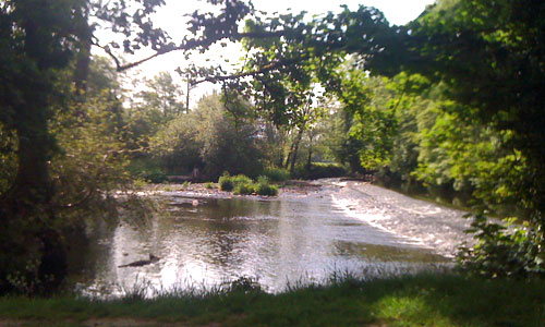
The River Exe meanders through a deep and dramatic wooded valley lined with lush oak woodlands displaying changing seasonal colours. Its side valleys are particularly quiet and secretive, with a very strong sense of enclosure. The historic town of Tiverton sits on the banks of the river, its red sandstone churches, castle, bridges, school and impressive early19th century textile mill dominant in the scene. South of Tiverton, the Exe valley landscape opens out into a patchwork of fields, woodlands and copses with a much gentler character.
- Context
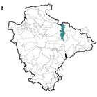
 This area runs north-south and contains the middle reaches of the River Exe, extending westward to include the lower parts of two of its tributaries. To the west is the higher land of the Cruwys Morchard Wooded and Farmed Valleys; and to the east the higher land of the Bampton and Beer Downs and the Cullompton Rolling Farmland. To the south is a more gradual transition from the wider Exe Valley floor into the Yeo, Culm and Exe Lowlands. To the north is the county boundary with Somerset, although the character of the Exe Valley continues beyond it.
 - Constituent Landscape Character Types
Constituent LCTs: 1E: Wooded Ridges and Hilltops, 3A: Upper Farmed and Wooded Valley Slopes, 3C: Sparsely Settled Farmed Valley Floors, 3G: River Valley Slopes and Combes, 3H: Secluded Valleys, 7: Main Cities and Towns Part of NCA: 148: Devon Redlands - Distinctive Characteristics
- Underlying Culm Measures geology of Carboniferous mudstone, siltstone and sandstone, with a distinctive area of red Permian sandstone around Tiverton.
- Dramatic topography, particularly in the northern part of the area, with the Exe flowing through a steeply incised valley (fed by steep-sided tributary valleys) which gradually widens towards the south.
- Tree-lined River Exe, fast-flowing in the northern part of the area, but wider and more tranquil in the southern part, supporting fish populations including salmon and trout.
- Extensive woodlands flanking the valley, contrasting with the flat and open valley floor; south of Tiverton, less continuous woodland, but Back’s Wood is a fine example of wet woodland.
- Agriculture confined to valley-bottom in the northern part of the area, gradually opening out into a patchwork of arable and pastoral fields south of Tiverton.
- Field systems of variable date, including extensive surviving medieval enclosures in the Dart valley and to the west of Bampton; Castle Close prehistoric hillfort ‘fossilised’ within the surrounding field system.
- Fields divided by thick hedgerows, with some hedgerow trees.
- Semi-natural habitats including wet and valley-side woodlands, and wet, rushy meadows on valley floors.
- Pre-historic, Roman and medieval forts and castles occupying prominent positions overlooking the main and tributary valleys.
- Former quarrying sites (particularly around Cove and Bampton) that remain visible in the landscape.
- Numerous historic structures associated with the river, including stone bridges, chain bridges, mills, weirs etc, and the famous Tiverton lace mills built by John Heathcote in the early 19th century.
- Market town of Tiverton situated at the mid-point of the valley, at the confluence of the Rivers Exe and Lowman, and containing many fine 18th and 19th century buildings.
- Attractive villages (e.g. Bickleigh, Cove, Bolham) with traditional cob and thatch cottages, nestled into the rolling landform and often close to river crossings; occasional locally-distinctive red sandstone buildings.
- Rural lanes and main roads (A396 and part of the A361) following the valley floor that are popular scenic routes.
- An attractive landscape, with enclosed views within the valley and contrasting dramatic views into and across the valley from higher land on the valley sides.
- Tributary valleys retaining a strong sense of quietness and remoteness.
Evaluation
- Special Qualities and Features:
- A distinctive landscape of high scenic quality.
- Visible in views southwards from Exmoor, contributing to the setting of the National Park.
- Attractive settings for several settlements, including Tiverton and Bampton.
- SSSIs at Kersdown Quarry and Five Oaks (near Bampton) designated for their geological exposures and fossils.
- Extensive CWSs, including many ancient woodlands on steep valley sides (supporting notable lichen populations) and some grassland sites.
- LNRs at Palmerston Park Wood and Northdown Wood enabling public access into the countryside.
- Impressive SMs charting the defence of the area over millennia, including Cranmore Castle and Castle Close prehistoric hillforts, Bolham Hill Roman fort (north of Tiverton), and medieval castles at Bampton and Tiverton, the latter having been under siege in the Civil War and then occupied by Oliver Cromwell.
- Conservation Areas covering the historic cores of Bampton, Cover, Bolham, Oakfordbridge, Tiverton and Bickleigh, plus other historic buildings such as mills, cottages, farms and bridges throughout the area.
- Strong cultural association with textile industries, particularly weaving and lace-making, with the riverside mills and workers’ housing still a distinctive feature of the Tiverton.
- Many recreational attractions, including Tiverton Museum, Devon Railway Centre at Bickleigh Mill, Bickleigh Castle and Tiverton Castle; plus Exe Valley Way providing recreational access along the valley.
Forces for Change and Their Landscape Implications:
- Past and Current
- Sight and sound of traffic on A396 and A361 North Devon Link Road, reducing tranquillity.
- Increasing traffic, damaging roadside hedgerows and hedgebanks; and loss of roadside trees as a result of Highways safety measures.
- Increased tourism and associated river activities e.g. angling, walking, kayaking and canoeing, giving the valley landscape a more recreational character.
- Sporadic valley bottom development including sewage works and farm buildings, introducing new features into the landscape.
- Invasive water-borne weeds such as knotweed and Himalayan Balsam affecting native riparian vegetation and habitats.
- New pests/ diseases infecting trees (e.g. Phytophthora, Sudden Oak Death) potentially resulting in the loss of large areas of valley-side woodland.
- Intensification of farming leading to (for example) loss of hedgerows and habitats for farmland birds, particularly in the southern half of the area.
- Past planting of conifers on valley sides.Past quarrying that has left scars on the landscape, particularly at Holmingham.
- Development on the western bank of the Exe at Tiverton creeping up the valley side and becoming increasingly prominent in the landscape.
- Light pollution from Tiverton.
- Localised problems of fly tipping.
- Future
- Potential decline of historic buildings and structures, particularly where redundant from their original use.
- Loss of water quality due to farming activities and increased public use, affecting aquatic and riparian plants and animals.
- Increased recreational pressure associated with growth in home tourism, further changing the character of the landscape.
- Further development pressure – particularly around Tiverton – resulting in building on floodplains (potentially increasing flood risk locally and downstream) and high on valley sides (potentially increasing the visibility of the town from the surrounding area).
- Change in seasonal weather patterns, potentially causing increased winter flooding and summer drought, leading to loss of water- and drought-intolerant species and changes in farming practices.
- Increased tree loss as a result of new pests and diseases; and increased magnitude and frequency of storm events as a result of climate change.
- Potential demand for renewable energy schemes, including hydro-electric power on the River Exe and its tributaries, and wind turbines and biofuel crops on the more open land in the southern part of the area.
- Domestic and community scale schemes with potential cumulative impact on the character of the landscape and built environment.
Strategy
- Overall Strategy:
To protect the landscape’s high scenic quality and strong sense of place within the southern setting of Exmoor National Park. The distinctive qualities of the River Exe and its steep wooded valleys are protected and enhanced. The area’s important industrial archaeology and defensive structures are protected and appropriately managed. Sustainable levels of recreation are encouraged, achieving a balance between recreation and conservation interests. Farmland is well managed, and its biodiversity increased.
Guidelines:
- Protect
- Protect floodplains by resisting inappropriate development.
- Protect the setting of settlements such as Tiverton and Bampton.
- Protect historic built features and their settings, including the area’s valuable industrial archaeology, introducing sensitive interpretation where appropriate.
- Protect archaeological sites and their settings, introducing suitable levels of clearance, grazing, visitor access and interpretation where appropriate.
- Protect surviving historic buildings, ensuring that any new development is sympathetic in terms of materials, styles and location.
- Protect the sense of peacefulness and remoteness where it survives, particularly in tributary valleys.
- Manage
- Manage deciduous woodland (including by traditional techniques such as coppicing and grazing) to encourage woodland regeneration, age- and species-diversity and diverse ground flora; educate the public on how to minimise the spread of infectious tree diseases.
- Manage coniferous plantation to increase its biodiversity and recreational value (e.g. introducing mountain bike trails).
- Manage copses, riparian trees, hedgerows and hedgerow trees, replacing them where necessary to ensure their continued presence in the landscape.
- Manage and ideally control or eradicate invasive water-borne weeds.
- Manage semi-natural habitats to maximise their biodiversity.
- Manage recreation and associated river activities such as angling and canoeing to minimise both conflict between different users and the visual and wildlife impacts of recreational activities.
- Manage farmland, enhancing biodiversity and ensuring that landscape features such as hedgerows are well maintained
- Plan
- Plan screen planting along main roads where necessary to minimise visual and noise intrusion of traffic.
- Plan appropriate highways measures to retain roadside woodland and trees whilst maintaining road safety.
- Plan to extend and link areas of semi-natural habitat to increase their value as wildlife corridors and their resilience to climate change.
- Plan to revert coniferous plantation on valley sides to broadleaved woodland on maturity and felling, and to restore and expand areas of ancient broadleaved woodland.
- Plan to research treatments and preventative methods for tree diseases such as Phytophthora pathogens.
- Plan to explore opportunities for small-scale hydro-power.
- Plan to minimise the visual impact of future development at Tiverton through careful design, siting and screening.
- Plan to reduce light pollution from Tiverton.