The central focus of this area is the prominent wooded ridge of Pebble Beds which has a distinctive pattern of heaths and former commons (including areas of gorse, scattered pines, and notable tree groups) and woodland (both beech and conifer plantation). The ridge with its blocks of largely plantation woodland creates a recognisable skyline feature and focus for surrounding areas including the Exe Estuary, undulating farmland and the Otter valley. The areas of heath and woodland give rise to a wild, colourful and untamed feel and a sense of remoteness despite the area being highly popular for recreation. From more open areas on the ridge there are panoramic views across surrounding farmland and to the coast. In the north the ridge declines in height and the farmland has a semi-urban character affected by urbanising influences and horsiculture. In the lower Otter valley the historic settlement pattern above the valley floor, valley meadows and pastoral character are distinctive, set between the Pebble Bed ridge to the west and the sharply rising slopes of the greensand ridges to the east.
- Context
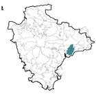
 This area comprises a north-south orientated prominent ridge and surrounding undulating farmland which is visually influenced by the ridge. To the north and west the outer edges of this area are transitional as the dominance of the ridge declines and the landform drops in elevation into the Clyst Lowlands. To the south the area is bounded by the Sidmouth and Lyme Bay Coastal Plateau and to the east by the sharply rising edge of the greensand ridges. This character area includes the lower reaches of the Otter valley to the east.
 - Constituent Landscape Character Types
Constituent LCTs: 1B: Open Coastal Plateau, 1C: Pebble Bed Heaths, 3B: Lower Rolling Farmed and Settled Valley Slopes, 3C: Sparsely Settled Farmed Valley Floors, Part of NCA: 148: Devon Redlands - Distinctive Characteristics
- Elevated prominent ridge underlain by Bunter Pebble Beds giving rise to sandy soils and loamy brown soils in the surrounding farmland.
- Small streams that drain the ridge and form gentle undulations and valleys extending into the surrounding farmland, often associated wet heath and valley mires.
- Well-wooded, particularly the south and west slopes which form a distinctive wooded skyline.
- Oak/ash semi-natural ancient woodland with hazel/holly understorey and bluebell and wood anemone flowers; some areas replanted with conifer and beech.
- Tree-lined watercourses and small farm copses and hedgerow oaks that give a well wooded appearance to the wider farmland surrounding the ridge
- Few enclosures on elevated ridge with variable field sizes and irregular patterns in the surrounding farmland, with boundaries comprising Devon hedgebanks.
- Some areas where there is evidence of ‘open fields’ and strip farming.
- Open heathland areas; surrounded by mainly dairy farming with some fodder crops and orchards on drier slopes near farmsteads and settlements.
- Patches of gorse, bracken, mire, acid grasslands and remnant heath on upper slopes; ancient woodlands; and areas of species-rich meadow and rush pasture fringing streams.
- Iron Age hillforts in commanding positions above surrounding landscape.
- Notable areas of parkland within a wider farmed landscape.
- Settlement on ridge limited to a few isolated farms; surrounding farmland and Otter valley have a pattern of nucleated villages at river crossing points and dispersed farmsteads.
- Some larger villages that have spread outside their historic cores (e.g. East Budleigh) or are characterised by suburban housing set in woodland (e.g. West Hill and Broad Oak).
- Strong local vernacular with regular use of stone with slate roofs.
- Views out to sea and also across Exe Estuary to the west.
Evaluation
- Special qualities and features
- Distinctive, unspoilt, wooded skyline providing local distinctiveness and orientation.
- High scenic quality reflected in designation of southern two-thirds of area as part of East Devon AONB.
- Outstanding views across East Devon to west and east and also south to the coast.
Sense of isolation, tranquillity and remoteness, enhanced by natural qualities of the heath, woodland and commons. - Rarity value as one of Devon’s few areas of remaining lowland heath.
- Varied wildlife habitats including SSSI, SAC and SPA designations on heathland habitats valued for endangered species such as Dartford Warbler, Nightjar and invertebrates.
- Other habitats of value including ancient semi-natural and broadleaved woodland.
Bicton and Cadhay Historic Parks and Gardens (Grade I and Grade II registered respectively) which include historic wood pasture and parkland and nationally significant population of veteran trees at Bicton. - Woodbury and Belbury Castles (Iron Age hillforts, SM) and numerous Bronze Age burial mounds (SM) on the ridge.
- Picturesque villages with traditional buildings linked by narrow winding lanes crossing historic stone bridges; many listed buildings.
- Valued area for recreation with good access provision and high carrying capacity.
- Woodbury Common associated with Arthur Mee and described in Peach L Du Garde Guide to Unknown Devon.
Forces for Change and Their Landscape Implications:
- Past and current
- The past planting of coniferous shelterbelts and plantations forming conspicuous features and stark blocks on the ridge, causing loss of former common and ancient woodland.
- Decline in woodland management including coppicing and spread of alien species affecting the appearance and biodiversity of the landscape’s woodlands.
- Enclosure and reclamation of heath to smallholdings and paddocks resulting in an urban fringe character in the north.
- Sand and gravel extraction.
- Development of large houses in extensive ground on the fringes of the ridge giving rise to a suburban character in places.
- Hedgerow removal in the drive for agricultural intensification, spurred on by the introduction of the Common Agricultural Policy in the 1970s; replacement with post-and-wire fencing, affecting the integrity of field patterns.
- Lack of hedgerow management (laying and coppicing) leading to hedgerow loss and gappy hedges.
- Conversion of former areas of meadowland in the Otter valley to arable, beginning in the late 18th century and intensifying after the Second World War.
- Pony paddocks in farmland surrounding the ridge particularly to the north and on edges of settlements, with suburbanising influence as smallholdings are taken out of traditional agricultural management.
- Invasion of scrub and woodland on areas of former common and heath affecting ecological value of these areas.
- Recreation pressures resulting in areas of path erosion, development of golf courses and growing traffic levels on rural roads, particularly at holiday time.
- Peace and tranquillity interrupted by the A30 in the northern part of the area.
- Use of heathland for training by the Royal Marines.
- Past quarrying activity towards the western edge of the Pebble Bed ridge at Blackhill.
- Future
- Increase in the area of coniferous plantation and woodland planted to filter water, minimise downstream flooding, store carbon and provide low carbon fuel (through coppice management).
- Potential loss of or change ancient semi-natural woodlands due to spread of Phytophthora, intolerance of water level extremes and more frequent storm events.
- Changes in crops and land use as a consequence of change in climate and markets e.g. new markets for bioenergy crops.
- Higher demand for domestic food production, potentially leading to an increase in stocking levels (risk of poaching and over-grazing) and intensification of agriculture on more fertile valley pastures (increased risk of diffuse pollution in watercourses).
- Longer growing season and faster growth of bracken, gorse and secondary woodland resulting in a decrease in remaining areas of heathland and rush pasture.
- More intense periods of drought, as a result of climate change, leading to the drying out of important wetlands including wet meadows and rush pasture.
- Increased autumn and winter precipitation leading to higher water levels and consequent increases in poaching of stream banks and flood risk in lower catchments.
- Development pressure within the area and along the main A30 corridor, particularly due to its attractiveness of the area as a place to live.
- Increased demand for wind turbines and communications masts on higher ground as well as for domestic and community-scale solar panels and small wind turbines, with cumulative impact on landscape.
Strategy
- Overall strategy
To protect the landscape’s role as a visual focus and distinctive wooded skyline for surrounding landscapes, strengthening its special qualities and features – in particular its lowland heath habitats and distinctive tree groups. Opportunities are sought to restore conifer plantations to broadleaved and heathland habitats. Field patterns are reinforced through the restoration and management of distinctive beech hedgebanks. Distinctive tree clumps on the heath as well as valley-side woodlands are managed; and wetlands are expanded to help prevent downstream flooding and protect water quality. The landscape’s time-depth continues to have a strong influence, whilst opportunities for sustainable recreation and limited low-carbon development are sensitively accommodated. The peaceful and historic character of nucleated settlements is enhanced.
Guidelines:
- Protect
- Protect the distinctive, wooded skylines formed by the Pebble Bed ridge.
- Protect the area’s outstanding views across East Devon.
- Protect unenclosed areas on the ridge and limit temporary enclosure to military activity or nature conservation initiatives, ensuring that any enclosure is low key and unobtrusive.
- Protect the landscape’s strong sense of tranquillity and remoteness with areas of semi- natural vegetation reinforcing a sense of wildness.
- Protect and appropriately manage the rich cultural heritage of the area, such as Bronze Age barrows, Iron Age hillforts and medieval strip fields, including through livestock grazing at appropriate levels and recreation management.
- Protect the unsettled character of the ridge and sparse settlement pattern of clustered hamlets, villages and farmsteads in surrounding farmland. Prevent the linear spread of development along river valleys and roads to maintain the settlements’ characteristic form and peaceful character.
- Protect traditional building styles and materials utilising the same styles and materials in new development wherever possible (whilst seeking to incorporate sustainable design).
- Protect and restore historic features within the valleys, particularly those relating to the rivers such as mills and bridges.
- Protect the landscape’s network of quiet lanes enclosed by woodland and species-rich hedgebanks, resisting unsympathetic highways improvements or signage.
- Manage
- Manage conifer plantations for sustainable timber production, recreation and wildlife, creating new green links to surrounding semi-natural habitats.
- Manage and enhance the valleys’ semi-natural woodlands through traditional techniques including coppicing and control access by livestock to promote natural regeneration; explore opportunities for community utilisation of coppice residues as a low-carbon fuel source.
- Use extensive grazing to promote the species diversity of woodland ground flora.
- Manage and ensure the future survival of the distinctive beech hedges; strengthen the field pattern by reinstating coppicing to mature sections and grown-out trees.
- Support farmers in management of heath as an integral part of their farming system. Manage through a continuation of livestock grazing at appropriate levels, along with a programme of scrub removal.
- Within the Otter valley, manage and extend species-rich meadows and floodplain grasslands through appropriate grazing and traditional land management regimes – both to enhance their wildlife value and function as flood prevention.
- Plan
- Plan for long-term restoration of the more prominent conifer plantations and shelterbelts to open habitats (where their role in timber production has ceased) including re-creation of heathland.
- Plan for the restoration of worked out quarries to heathland wherever feasible.
Create, extend and link woodland and wetland habitats to enhance the water storage capacity of the landscape, reducing soil erosion, agricultural run-off and downstream flooding and improving water quality. - Encourage the natural regeneration of woodland and new planting (using climate-hardy species) to link fragmented sites.
- Minimise soil erosion and reduce diffuse pollution by replanting of former hedgelines particularly along slopes to minimise soil erosion and reduce diffuse pollution.
- Restore and manage areas of relict traditional orchards and explore opportunities for the creation of new ones, including community orchards to promote local food and drink production.
- Plan for sensitive, low-key signage and interpretation about the biodiversity and interest of heathland habitats.