This is a low lying, intensively farmed landscape with a uniformity to its undulating topography except in the north where there are a couple of outliers of higher ground. The uniform topography and pattern of hedgerows and hedgerows trees mean that there are few distinguishing features and this coupled with winding rural lanes results in a landscape which can feel quite disorientating. A distinguishing element of the area are ‘Clyst’ place names which mean ‘clear water’ and the numerous small steams which drain the area, along with the more prominent Clyst and Tale valleys, are defining characteristics. This is a settled landscape with a dispersed pattern of villages and farmsteads and includes modern communications and infrastructure, namely the A30 corridor, railway lines, pylons and more recently Exeter Airport. It also includes the town of Honiton.
- Context
 This area comprises low lying farmland between Exeter and Honiton which is drained by a series of small steams feeding into the more pronounced valleys of the Clyst and Tale. The northern fringes of this area are marked by the distinctive hills of Budlake, the M5 corridor and Culm Valley although the change in character to the Culm Valley Lowlands is transitional. To the south the landscape is also transitional but distinguished by more undulating terrain and closer association with the Pebble Bed ridge. To the east the change in landscape is marked by the rising greensand ridges while to the west the boundary is clearly defined by the urban edge of Exeter and the Exe Estuary.
 - Constituent Landscape Character Types
Constituent LCTs:3A: Upper Farmed and Wooded Valley Slopes, 3B: Lower Rolling Farmed and Settled Valley Slopes, 3C: Sparsely Settled Farmed Valley Floors, 3E: Lowland Plains, 1E: Wooded Ridges and Hilltops
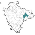
Part of NCA:148: Devon Redlands - Distinctive Characteristics
- Lowland, undulating farmed landscape underlain by mudstones, siltstones and sandstones.
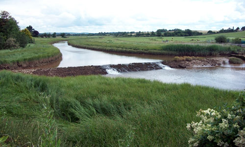
- Landscape crossed by streams and meandering watercourses which feed into the more distinct valleys of the Clyst (a tributary to the Exe) and the Tale (a tributary to the Otter).
- Higher ground to the north at Budlake (harder igneous geology) providing a more distinctive and often wooded skyline.
- Generally well treed appearance due to significant numbers of hedgerow trees although few woodlands with exception of Killerton Estate (part of Ashclyst Forest).
- Notable small orchards often on the outskirts of villages.
- Mixture of small to medium scale fields often with curving boundaries reflecting medieval origin.
- Mixed farming including arable and some pasture along watercourses where there is seasonal flooding, as well as areas of horsiculture and hobby farming.
- Nature conservation interest provided by unimproved neutral grassland and marshy grassland, particularly fringing streams and plantation/ semi-natural and ancient woodland in the north-west.
- Historic parkland in the north-west of this area with notable areas of parkland and veteran trees.
- Dispersed pattern of small villages (particularly along the watercourses many with ‘Clyst’ place names), dispersed farmsteads and town of Honiton.
- Strong local vernacular of cob and thatch.
- Overarching perceptions of tranquillity and quintessential English lowland farmland when away from infrastructure and communication corridors and a sense of isolation in parts.
- Views to surrounding ridges of higher land.
Evaluation
- Special qualities and features
- Well managed, generally low hedgerows enabling views to distinctive wooded skyline hills around Budlake and to the south (Pebble Bed Heaths), which help provide orientation and sense of place.
- Sense of tranquillity enhanced by natural qualities of the meandering streams and rivers.
- Killerton SSSI valued for its igneous geology exposed in small disused quarries.
- Other nature conservation interest mainly limited to patches of unimproved neutral grassland and marshy grassland or fen, traditional orchards, steam margins and areas of parkland containing veteran trees.
- Rich cultural heritage of the area’s hilltops, such as Bronze Age barrows, Iron Age hillforts and ancient settlement remains.
- Concentration of historic parklands in the north-west including Sprydon Park (National Trust), Killerton Park and House (National Trust) and Rockbeare Manor with one of the largest populations of veteran trees in Devon.
- Picturesque villages with traditional buildings linked by narrow winding lanes crossing historic stone bridges; many listed buildings and Conservation Areas at Sowton, Whimple and Ottery St Mary.
- Many buildings constructed of local stone e.g. Killerton Chapel.
- Clyst St Mary historically associated with the 1549 Prayer Book Rebellion.
William Makepeace Thackeray lived at Ottery St Mary; his novel Pendennis was set here.
Forces for Change and Their Landscape Implications:
- Past and current
- Past planting of coniferous shelterbelts and plantations conspicuous on higher ground in north-west.
- Loss of traditional orchards adjacent to villages.
- Decline in woodland management including coppicing and a spread of alien species affecting the appearance and biodiversity of the landscape’s woodlands (partly reversed in Ashclyst Forest through initiatives such as charcoal making).
- Hedgerow removal in the drive for agricultural intensification, spurred on by the introduction of the Common Agricultural Policy in the 1970s.
- Replacement of hedgerows with post-and-wire fencing, affecting the integrity of field patterns.
- Lack of hedgerow management (laying and coppicing) leading to grown out sections of beech, now susceptible to windthrow and storm damage.
- Conversion of former areas of pasture to arable, beginning in the late 18th century and intensifying after the Second World War.
- Pony paddocks on edges of settlements that have a suburbanising influence, as smallholdings are taken out of traditional agricultural management.
- 20th century expansion of Clyst St Mary with linear growth along roads, including business parks and recreation developments standing out in the landscape along the A3052.
- Growing demand for facilities such as caravan parks, holiday accommodation and visitor attractions – many as farm diversification enterprises.
- Recreation pressures and growing traffic levels on rural roads, particularly at holiday time.
- Development of Exeter Airport affecting tranquillity.
- Growth of Honiton.
- Heavy farm traffic leading to vehicular damage to roadside hedges and woodland.
- Removal of vegetation by Highways Authority leading to a change in character of roads.
- Peace and tranquillity interrupted by main roads in some valleys – particularly the A30.
- Pylons in the Clyst Valley that are visually dominant and affect tranquillity and sense of place.
- Draining and agricultural improvement of former moors and heaths such as Broadclyst Moor (evident on 1st edition OS).
- Future
- Uncertain future for the agricultural economy – levels of future agri-environment support and market prices for farmed products unknown.
- Changes in crops and land use as a consequence of change in climate and markets e.g. new markets for bioenergy crops.
- Higher demand for domestic food production potentially leading to an increase in stocking levels (risk of poaching and over-grazing) and intensification of agriculture on more fertile valley pastures (increased risk of diffuse pollution in watercourses).
- More intense periods of drought, as a result of climate change, leading to the drying out of important wetlands including wet meadows and rush pasture.
- Increased autumn and winter precipitation leading to higher water levels and consequent increases in poaching of river banks and flood risk in lower catchments.
- Development pressure within the area and along the main A30 and A3052 corridors, particularly due to the area’s attractiveness as a place to live close to Exeter and Honiton.
- Increased demand for wind turbines and communications masts on higher ground as well as for domestic and community-scale solar panels and small wind turbines, with cumulative impact on landscape.
- Growth in and around Exeter including planned development of Cranbrook New Town, transport interchange and industrial park in M5 and Exeter airport area.
- Increased recreational pressure due to associated population increase.
- Increased demand for woodfuel leading to re-intensification of use of Ashclyst Forest and other woodlands.
Strategy
- Overall strategy
To protect and enhance the landscape’s low-lying wetland character associated with streams and rivers and also the views to wooded skylines on hills within and around the area. Opportunities are sought to restore conifer plantations to broadleaves and heathland habitats on the higher land to the north which forms important skyline features and to sustain population of veteran trees within parklands. Field patterns are reinforced through the restoration and management of characteristic hedges. Distinctive tree-lined streams and wet grassland along watercourses are managed and expanded to help prevent downstream flooding, protect water quality and conserve and enhance wildlife. Traditional orchards are conserved and expanded where feasible. The landscape’s settlement pattern and place names continue to have a strong influence, whilst opportunities for sustainable recreation and limited low-carbon development are sensitively accommodated.
Guidelines
- Protect
- Protect the distinctive, wooded skylines at Budlake.
- Protect the landscape’s strong sense of tranquillity and remoteness with clustered villages and hamlets reinforcing a strong historic sense of place.
- Protect and appropriately manage the rich cultural heritage of the area’s hilltops through livestock grazing at appropriate levels and recreation management.
- Protect the character and setting of the parkland landscapes, ensuring any new development does not encroach upon the historic landscape or views to it.
- Protect the sparse settlement pattern of clustered hamlets, villages and farmsteads, preventing the linear spread of development along river valleys and roads wherever possible.
- Protect traditional building styles and materials, particularly cob and thatch, utilising the same styles and materials in new development wherever possible (whilst seeking to incorporate sustainable design).
- Protect the landscape’s network of quiet lanes enclosed by woodland and species-rich hedgebanks, resisting unsympathetic highways improvements or signage.
- Protect and repair characteristic built features such as stone hump-backed bridges.
- Manage
- Manage conifer plantations for sustainable timber production, recreation and wildlife, creating new green links to surrounding semi-natural habitats.
- Manage and enhance the valleys’ semi-natural woodlands and broadleaved plantations through traditional techniques including coppicing and control access by livestock and deer browsing to promote natural regeneration; explore further opportunities for community utilisation of coppice residues as a low-carbon fuel source.
- Manage the veteran trees – retain old trees free from competing younger tree growth and protect from overgrazing and ploughing; plant new veteran trees.
- Manage the landscape’s distinctive hedges to strengthen the strong square field pattern. Reinstate coppicing to mature sections and grown-out trees to ensure the future survival of these characteristic features.
- Within the valleys, manage and extend species-rich meadows and floodplain grasslands through appropriate grazing and traditional land management regimes – both to enhance their wildlife value and functions in flood prevention.
- Plan
- Plan for long-term restoration of the more prominent conifer plantations and shelterbelts to semi-natural habitats including re-creation of heathland and rush pasture, wood pasture (where its role in timber production has ceased) and broadleaved plantation.
- Create, extend and link woodland and wetland habitats to enhance the water storage capacity of the landscape, reducing soil erosion, agricultural run-off and downstream flooding and improving water quality.
- Encourage the natural regeneration of woodland and new planting (using climate-hardy species) to link fragmented sites.
- Minimise soil erosion and reduce diffuse pollution by replanting of former hedgelines (particularly using disease-resistant elm) to minimise soil erosion and reduce diffuse pollution.
- The planting (or selection) of hedgerow trees including oaks to provide vertical elements and future veterans for wildlife.
- Restore and manage areas of relict traditional orchards and explore opportunities for the creation of new ones, including community orchards to promote local food and drink production.
- Plan to ensure the sensitive location of new development and particularly new urban extensions of Honiton, avoiding prominent open ridges and slopes.
- Plan for a network of green spaces and green infrastructure links to support the current and future population of Honiton and other settlements in adjoining character areas.