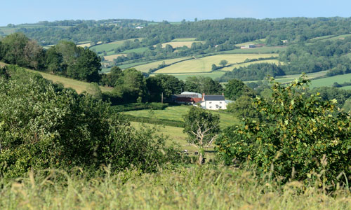
This landscape at its core comprises a central plateau landscape which is elevated, exposed and open in character and which fans out into narrow ridges at its edges where it is fringed by steeply sloping wooded greensand edges and farmed slopes which descend into river valleys. The interplay of open, elevated plateau (with its regular enclosure pattern and beech hedges, outgrown beech hedges and pine shelterbelts), the steeply sloping fringes (which are cloaked in woodland), and the farmed valleys (with small scale irregular enclosures) gives this landscape its distinctiveness. The expansive plateau and prominent beech shelterbelts, in particular, distinguish this area from the East Devon Central Ridge found further south and east. In places there is a sense of bleakness about the longer views across unbroken stretches of plateau.
- Context
 This area comprises an open, exposed inland plateau which fans out as narrow fingers towards the edges, fringed by steeply sloping, wooded greensand and more gentle wooded valley slopes particularly in the Culm Valley. The northern boundary to this area is formed by the Blackdown Scarp, and the southern boundary by the Clyst Lowland Farmlands which extend into the upper Otter valley around Honiton. To the west the landscape rapidly drops into the Culm Valley Lowlands while to the east it is defined by the East Devon Central Ridge and upper slopes of the Axe Valley.
 - Constituent Landscape Character Types
Constituent LCTs: 1A: Open Inland Planned Plateaux, 2A: Steep Wooded Scarp Slopes, 3A: Upper Farmed and Wooded Valley Slopes, 3C: Sparsely Settled Farmed Valley Floors Part of NCA: 147: Blackdowns - Distinctive Characteristics
- Elevated plateau underlain by clay-with-flints fringed by steep slopes of Upper Greensand.
- Landscape drained by streams and springs radiating out from the plateau area and draining into the Culm or Otter valley.
- Higher ground sparsely wooded with characteristic beech hedgebanks and some pine shelterbelts.
- Steep scarp slopes that are densely wooded – ancient oak with bluebells and primroses; and some conifer plantations which extend onto the ridges.
- Regular modern and Parliamentary fields of large and medium scale on the plateaux, reflecting late enclosure of common land, contrasting with smaller curving fields of medieval origin on valley slopes.
- Low narrow earthbanks with hedges on plateaux; with wider historic banks in the upper farmed valleys; and more species-diverse Devon hedges (e.g. beech, sycamore, ash, hazel and gorse) with flower, fern and moss-rich banks on lower slopes.
- Mainly pasture (often improved) and dairy farming with some mixed farming on heavy brown soils.
- Remnant areas of gorse, heathland and bracken on the plateau; ancient semi-natural and broadleaved woodlands on the scarp slopes; semi-improved and unimproved acidic and neutral grassland and springline mires (including carr woodland) occurring mainly on the scarp slope and in the upper farmed valleys.
- Bronze Age barrows in elevated positions on ridges; former castle sites in prominent locations at the ends of narrow ridges overlooking valleys; ancient settlement remains; remains of Cistercian abbey at Dunkeswell, all lending strong time-depth.
- Clustered hamlets and villages at road crossings and spring lines. Farmsteads scattered throughout, nestled in dips with beech shelterbelts.
- Straight roads with verges on narrow ridges descending abruptly and steeply to sinuous lanes defined tightly by close hedgebanks.
- Very distinctive building tradition that uses local cherts (flint-like nodules occurring occurs within greensand) with red brick detailing and slate roofs.
- Strong overarching perceptions of tranquillity and remoteness in many areas.
Evaluation
- Special Qualities and Features:
- Distinctive, unspoilt, and very exposed skylines often looking over the crowns of woodland on the steep greensand slopes with some views of the Wellington Monument in adjacent character area.
- High scenic quality reflected in the area forming part of the Blackdown Hills AONB.
- Outstanding views across East Devon and across the Otter and Culm valleys; northern vantage points offer extensive views across Somerset.
- Sense of isolation and remoteness, enhanced by exposure of the plateau; tranquillity provided by the dense woodland of the greensand scarps; one of the most tranquil areas in East Devon.
- Many CWSs and SSSIs including ancient semi-natural woodland e.g. Bywood Copse; semi-improved and improved acidic and neutral grasslands and spingline mires (e.g. Southey and Gotleigh Moors); and extensive areas of heathland and gorse scrub particularly on Black Down and Sampford Commons.
- Prominent Bronze Age barrows on Brown Down; earthwork remains of former castles e.g. Castle Neroche, Dumpdon Camp and Hembury Fort.
- Picturesque villages with traditional buildings linked by narrow winding lanes; many listed buildings.
- Early 20th century artist Robert Bevan and the Camden Group of artists associated with Clayhidon.
Forces for Change and Their Landscape Implications:
- Past and Current
- Field pattern is broken and hedgerows have been removed to facilitate more extensive farming methods.
- Development of military airfields at Dunkeswell, Trickey Warren and Smeatharpe, and subsequent development of commercial and air- and motor-based recreational activities impacting on tranquillity. Growth of villages including Dunkeswell including residential and small scale industrial units.
- Past planting of small coniferous plantations forming conspicuous features on higher ground and blurring the clear line between open ridge and wooded scarp slopes.
- Decline in woodland management including coppicing, and spread of non-native species affecting the appearance and biodiversity of the landscape’s woodlands.
- Hedgerow removal in the drive for agricultural intensification, spurred on by the introduction of the Common Agricultural Policy in the 1970s. Replacement with post-and-wire fencing, affecting the integrity of field patterns.
- Lack of hedgerow management (laying and coppicing) leading to grown out sections of beech, now susceptible to windthrow and storm damage.
- Conversion of former areas of moorland to pasture, beginning in the late 18th century and intensifying after the Second World War.
- Recent lack of grazing on ridge edges and steep valley sides, leading to spread of gorse and bracken.
- Heavy farm traffic leading to vehicular damage to roadside hedges and woodland.
- Removal of vegetation by highways authority leading to a change in character of roads.
- Further growth in popularity of the area for recreation and tourism from expanding towns of Taunton and Cranbrook.
- Future
- Increase in the area of coniferous plantation and woodland planted to filter water, minimise downstream flooding, store carbon and provide low carbon fuel (through coppice management).
- Potential loss of or change in oak- and beech-dominated valley woodlands due to spread of Phytophthora, intolerance of water level extremes and more frequent storm events.
- Uncertain future for the agricultural economy – levels of future agri-environment support and market prices for farmed products unknown.
- Longer growing season and faster growth of bracken, gorse and secondary woodland resulting in a decrease in remaining areas of heathland and rush pasture.
- More intense periods of drought, as a result of climate change, leading to the drying out of important wetlands including spring line mires and rush pasture.
- Increased demand for wind turbines and communications masts on higher ground as well as for domestic and community-scale solar panels and small wind turbines, with cumulative impact on landscape.
Strategy
- Overall Strategy
To protect the interrelationship and contrasts between open plateau, wooded scarp and intimate valley farmland which underpin the high scenic quality of this area. Opportunities are sought to restore conifer plantations to broadleaves and heathland habitats, reinforcing the distinction between the landscape types that make up this character area and strengthening the network of valuable heathland habitat. Field patterns are reinforced through the restoration and management of distinctive hedgebanks and shelterbelts. Scarp woodlands are managed and valley side wetlands are expanded to help prevent downstream flooding and protect water quality. The landscape’s time-depth continues to have a strong influence, whilst opportunities for sustainable recreation and limited low-carbon development are sensitively accommodated. The open expansive views from the plateau landscape and its unfettered skylines are protected.
Guidelines:
- Protect
- Protect the distinctive, unspoilt, and exposed skylines of the central plateau and radiating ridges and the views afforded from these elevated locations.
- Protect and appropriately manage the rich cultural heritage of the area’s hilltops, such as Bronze Age barrows, castles, including through livestock grazing at appropriate levels and recreation management.
- Protect the sparse settlement pattern of clustered hamlets, villages and farmsteads. Prevent the linear spread of development along roads and ensure new development reinforces traditional building styles and materials, particularly local chert with red brick detailing.
- Protect the landscape’s network of quiet lanes and the contrast in character between those on the plateau and those on the greensand scarps and valley slopes, resisting unsympathetic highways improvements or signage.
- Manage
- Manage the landscape’s distinctive beech hedges and shelterbelts on the plateau to strengthen the strong square field pattern. Reinstate coppicing to mature sections and grown-out trees to ensure the future survival of these characteristic features.
- Manage conifer plantations for sustainable timber production, recreation and wildlife, creating new green links to surrounding semi-natural habitats.
- Manage and enhance the semi-natural woodlands through traditional techniques including coppicing and control access by livestock to promote natural regeneration. Explore opportunities for community utilisation of coppice residues as a low-carbon fuel source.
- Use extensive grazing to promote the species diversity of woodland ground flora.
- Respect the traditional methods and styles of construction, including stone facing on banks.
- Support farmers in management of ‘marginal’ areas as an integral part of their farming system. Manage rough grassland, heath and rush pasture through a continuation of livestock grazing at appropriate levels, along with a programme of scrub removal.
- Within the valleys, manage and extend species-rich meadows and floodplain grasslands through appropriate grazing and traditional land management regimes – both to enhance their wildlife value and function as flood prevention.
- Plan
- Plan for long-term restoration of the more prominent conifer plantations and shelterbelts to semi-natural habitats (where their role in timber production has ceased) including re-creation of heathland on the plateau and broadleaved woodland on steep scarp slopes.
- Create, extend and link woodland and wetland habitats to enhance the water storage capacity of the landscape, reducing soil erosion, agricultural run-off and downstream flooding and improving water quality.
- Extend and link fragmented woodland sites through natural regeneration and new planting (using appropriate native climate-hardy species).
- Minimise soil erosion and reduce diffuse pollution by replanting of former hedgelines particularly along slopes to minimise soil erosion and reduce diffuse pollution.
- Plan for new uses of redundant airfields, ensuring new development is visually integrated and that it is sustainable.