This is a transitional landscape, linking the upland moor with the Tamar valley to the west, and forming the backdrop to many views of Dartmoor from the west. It is a secretive landscape of enclosing hills, deep valleys and sunken lanes, but with occasional unexpected and magnificent views towards the moorland and across the Tamar Valley. The landscape contains a mosaic of moorland, small fields and woodland, creating rich contrasts of colour, scale and texture. A sense of history pervades through the stone walls, hedgebanks, lanes and villages and the landmarks such as Brent Tor and White Tor. The town of Tavistock – built of greenish local stone – is the largest settlement in the area and also has a rich history.
- Context
 This area comprises the western part of Dartmoor and land to the west including the town of Tavistock. It encompasses upland moorland and the west-facing farmed slopes below it, running down towards the Tamar valley. It forms a transition from upland to lowland, and its boundaries with surrounding character areas are gradual. To the east are High Dartmoor North and Central Dartmoor; to the south and west the River Tavy Middle Valley and the Tamar Upland Fringe, and to the north the Upper Tamar Tributary Valleys.
 - Constituent Landscape Character Types
Constituent LCTs: 2D: Moorland Edge Slopes, 3D: Upland River Valleys, 1L: Upland Moorland with Tors, 5A: Inland Elevated Undulating Land, 3G: River Valley Slopes and Combes, 3F: Settled Valley Floors, 7: Main Cities and Towns PART OF nca: 150:Dartmoor - Distinctive Characteristics
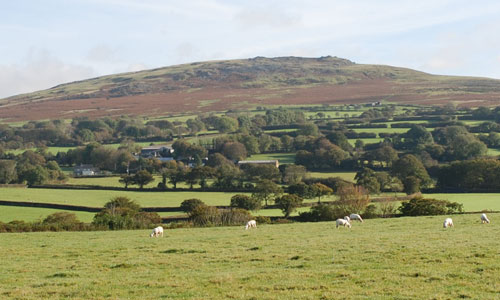
- The western side of the granite ‘dome’ of Dartmoor, but with a complex, undulating topography of plateau-like ridges separating the larger valleys of the Tavy and Lyd.
- Smooth skylines, occasionally broken by rocky tors and boulders.
The distinctive landmark of Brent Tor – a former volcano of basalt surmounted by a church. - Narrow, fast-flowing and rocky streams flowing through steep, often wooded valleys including Lydford Gorge, created by geological uplift of the Dartmoor plateau.
- The Tavy valley, distinctive for its wide and fast-flowing river, its bridges, attractive villages and England’s largest hydroelectric power station – at Mary Tavy – opened in 1932.
- Extensive areas of deciduous and mixed woodland in the north of the area around Lydford Gorge; elsewhere woodland generally limited to valley floors and sides.
- Abrupt contrasts in landscape colour and texture between relatively bleak open moorland and enclosed farmland.
- High moorland common in east, grazed by Dartmoor ponies and local sheep and cattle breeds.
- Valley side slopes mainly pastoral, with some arable farming on lower land.
Strong, intact field patterns of small, irregular medieval fields on the valley slopes, divided by stone walls, hedgebanks (with individual and linear groups of trees) and hedgerows. - Outlying uplands (e.g. Whitchurch Down, Black Down) of close-grazed unimproved grass moorland.
- Rich diversity of semi-natural habitats, including heather moorland, heath, blanket bog, mires and grassland in areas close to High Dartmoor (e.g. White Tor).
- Prehistoric and medieval archaeological features on moorland, including ceremonial sites, settlements, boundary stones, field systems and industrial archaeology associated with tin and copper mining.
- Settlement mainly isolated farms and small villages in valleys and sheltered folds of the hills; larger settlement of Tavistock formerly important as a stannery (where tin production was regulated).
- A strong local vernacular tradition using local granite, its greenish tinge being particularly noticeable in the buildings of Tavistock.
- A network of twisting, sunken lanes which can give a sense of disorientation.
Urbanising influences around Tavistock affecting the rural character of the landscape. - Visual impacts from the A386, particularly where it crosses areas of open moorland.
Unexpected and impressive views onto the moorland and across the Tamar valley.
 This area comprises the western part of Dartmoor and land to the west including the town of Tavistock. It encompasses upland moorland and the west-facing farmed slopes below it, running down towards the Tamar valley. It forms a transition from upland to lowland, and its boundaries with surrounding character areas are gradual. To the east are High Dartmoor North and Central Dartmoor; to the south and west the River Tavy Middle Valley and the Tamar Upland Fringe, and to the north the Upper Tamar Tributary Valleys.
Evaluation
- Special qualities and features:
- A landscape of very high scenic quality, largely within Dartmoor National Park and prominent in views of Dartmoor from Cornwall and the Tamar valley AONB.
- Outstanding views westwards across the Tamar valley AONB.
- High levels of remoteness and tranquillity, particularly in upland areas and along sunken lanes.
- Dark, starlit night skies, particularly away from the influence of Tavistock.
- Moorlands on the eastern edge of the area within Dartmoor SAC and SSSI; moorlands also fulfil an important role in water catchment, filtration and storage, and carbon sequestration.
- Lydford Gorge designated SSSI for gorge formation, river capture, ancient woodland and bryophytes (mosses and liverworts) and forming part of the south Dartmoor Woods SAC.
- Extensive areas of ancient woodland, particularly around Lydford Gorge, and on valley sides.
- Many valued wildlife habitats, including SSSIs and CWSs on downland, former mineral workings, streams and woodland; outlying areas of moorland forming extensive upland commons.
- RIGS site covering a geological exposure adjacent to the A386, north of Mary Tavy.
- A very strong sense of time-depth, the prehistoric forts at White Tor and Brent Tor being prominent hill-top features in the landscape.
- Numerous prehistoric and medieval SMs on the moorland (including ceremonial sites, hut circles, field systems and burial cairns) and later industrial archaeology associated with tin and copper mining.
- Important valley archaeology including Lydford’s Norman castle and the medieval remains of Tavistock Abbey (both SMs).
- Eastern gateway to the Devon and Cornwall Mining Landscape World Heritage Site at Tavistock.
- Industrial archaeology associated with the hydroelectric power station at Mary Tavy.
- Conservation Areas at Tavistock, Whitechurch, Horabridge, Brentor, Mary Tavy and Lydford, plus numerous historic houses, farms, stone bridges and villages throughout the area.
- Extensive areas of access land, West Devon Way long distance route and many popular recreation sites, including Brent Tor, Lydford castle and gorge and picturesque villages.
Forces for change and their landscape implications:
- Past and current
- The spread of modern development on the edges of Tavistock, with associated visual impacts on the south-western part of the area.
- Visual impacts of the A386, reducing tranquillity.
- Loss of upland semi-natural habitats due in part to over-grazing of outlying areas of moorland common.
- Concentrations of livestock in some riverside locations causing poaching on river banks and diffuse pollution.
- A lack of woodland management resulting in a localised loss of species diversity.
- Spread of non-native species within woodland, e.g. pink purslane.
- Intensification of agriculture and gradual loss of traditional skills such as stone walling resulting in an erosion of traditional agricultural landscape features such as hedgebanks.
- Intensive recreational use of upland areas resulting in erosion and damage to paths, and damage to geological and archaeological features. Traffic and overcrowding associated with ‘honeypot’ tourist sites.
- Quarrying in the vicinity of the area, with associates visual and noise impacts.
- Future
- Development pressure from within and outside the National Park (e.g. Plymouth conurbation) leading to potential demand for new water supply reservoirs and aggregate quarries.
- Demand for small-scale quarrying for local building stone within and close to the National Park.
- Further recreational demand from expanding urban centres in the vicinity, such as Plymouth.
- Increased areas of coniferous plantation and woodland to filter water, minimise downstream flooding, store carbon and provide low carbon fuel (through coppice management).
- Potential loss of or change in oak and beech-dominated valley woodlands due to spread of Phytophthora, intolerance of water level extremes and more frequent storm events.
- Changes in agricultural grants and funding potentially affecting grazing levels and the repair of traditional landscape features such as hedgebanks.
- Large modern agricultural buildings out of scale with traditional farmsteads and buildings.
- Climate change potentially affecting growing seasons, temperature and precipitation levels, resulting in habitat loss and changes in species composition.
- Increased autumn and winter precipitation leading to higher water levels and consequent increases in poaching of river banks and flood risk in lower catchments.
- Future demand for wind turbines and communications masts on higher ground, and for domestic and community-scale renewables, with cumulative impacts on the landscape and biodiversity.
- Potential additional future hydro-power schemes.
Strategy
- Overall Strategy:
To protect the landscape’s scenic quality and open skylines, strengthen its special qualities and features, and enhance its appearance as a key element within views of Dartmoor from the west. The area’s strong historic character is protected and enhanced, the time-depth associated with archaeological sites, field patterns and historic settlements being retained. Sustainable agriculture is supported, and upland commons are managed to increase their biodiversity through appropriate management and grazing. Recreation and enjoyment of the landscape are encouraged, but without detriment to fragile sites or features. Urban expansion around Tavistock is controlled to minimise its impacts on the setting of the National Park.
Guidelines:
- Protect
- Protect and appropriately manage the landscape’s numerous historic sites and features, including prehistoric hillforts, hut circles, cairns, settlements, field systems, and medieval tin working features, castles and ecclesiastical sites.
- Protect and maintain the small-scale medieval field patterns on the valley sides, restoring hedgebanks and walls using traditional techniques and materials.
- Protect the area’s sparsely settled character and views to high moorland, carefully controlling new development outside existing settlement envelopes.
- Protect the strong unifying local vernacular of granite and slate; new development should utilise similar materials and styles whilst seeking to incorporate sustainable design.
- Protect the open skylines and distinctive geological features of the landscape, including the granite tors; remove scrub through appropriate grazing where necessary, and provide guidance and interpretation to enhance public understanding of sites.
- Protect the valuable habitats.
- Protect the landscape’s network of quiet lanes enclosed by species-rich hedgebanks, resisting unsympathetic highways improvements or signage.
- Protect and repair characteristic built features such as stone hump-backed bridges.
- Protect high levels of tranquillity and dark skies, resisting developments which would damage these qualities.
- Manage
- Manage archaeological sites and their settings, with sensitive interpretation as necessary.
- Manage and enhance areas of upland common and Rhôs pasture through appropriate levels of livestock grazing to enhance biodiversity and maintain the open moorland landscape.
- Manage and enhance the valleys’ semi-natural woodlands through traditional techniques (including coppicing and grazing) and control of non-native species to promote longevity, species diversity and wood fuel.
- Manage recreational pressure (particularly in ‘honeypot’ sites such as Lydford Gorge and Brent Tor) to minimise damage to habitats, wildlife and archaeological features; alternative locations and sustainable transport options could also be promoted.
- Plan
- Plan to create, extend and link semi-natural habitats such as heathland, wetlands, meadows, Rhôs pasture and woodlands.
- Plan to explore the area’s potential for additional hydroelectric schemes that can be sensitivity incorporated into the landscape without unacceptable damage to wildlife.
- Plan to ensure that any new quarrying activities are visually unobtrusive.
- Plan green infrastructure networks between Tavistock and the surrounding countryside, to improve connectivity and provide a framework for potential future sustainable development.