This is a high, wild, bleak and evocative landscape which forms the skyline to many views within and beyond Dartmoor National Park to the south, west and east. Although smaller in extent than High Dartmoor North, it can feel even more remote from significant areas of settlement. It is covered in extensive areas of blanket bog and mire which form the sources of many of South Devon’s rivers. The landscape is devoid of modern settlement, roads or other features, yet presents a rich archaeological heritage in the forms of prehistoric ceremonial sites and settlements, and later evidence of mining activity, peat extraction and clay working. It is a landscape which is highly valued for its nature conservation importance, and also for its vital role as a water catchment. In this exposed landscape, the weather has a strong influence on the sense of place, ranging from all-encompassing rain and mist to clear skies, strong colours and outstanding views across south Devon to the sea.
- Context
T
 his area comprises the highest land to the south of the Dart valley and forms an upland plateau covered by blanket bog. At the edges of the area there is a gradual transition into the surrounding character areas of Central Dartmoor to the north, and Southern Dartmoor and Fringes to the south.
 - Constituent Landscape Character Types
Constituent LCTs: 1K: Unsettled High Upland Moorland Part of NCA: 150: Dartmoor - Distinctive Characteristics
- Elevated land on the top of the impermeable granite dome which underlies Dartmoor.
- Gently undulating topography with shallow river valleys.
- A landscape which is almost entirely devoid of trees, but with occasional outcrops or tors on the skyline.
- Unenclosed moorland grazed by ponies, cattle and sheep.
- Extensive areas of blanket bog and mire, forming numerous ‘heads’ or river sources from which flow many of Devon’s rivers, including the Plym, Avon, Erme and several tributaries of the river Dart.
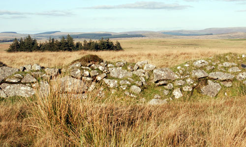
- A rich and visible archaeological heritage of prehistoric (Bronze Age) sites including settlements, boundaries and standing stones.
- Numerous industrial archaeology sites from the medieval and post-medieval periods, including relicts of medieval tin working in the form of tin streaming, open works, tinners’ mills and buildings.
- Numerous pillow mounds at Huntingdon Warren indicating historic rabbit farming. An absence of modern settlement, roads or other features, and very limited footpath access giving the landscape a strong sense of emptiness.
- Outstanding long-distance views, particularly southwards across south Devon to the sea.
Evaluation
- Special Qualities and Features
- Very high scenic quality (area lies within Dartmoor National Park).
- Smooth, open skyline in views from within and beyond Dartmoor National Park to the south, east and west.
- Outstanding views across Plymouth and the indented coastline of South Hams to the sea.
- Outstanding qualities of remoteness and tranquillity (one of the most extensive areas of high tranquillity in Devon) with exceptionally dark, starlit night skies.
- Nationally and internationally designated (SSSI and SAC) for its blanket bogs and other moorland habitats which support bird species such as snipe.
- Blanket bogs and mires that perform important roles in water catchment, filtration and storage, and carbon sequestration.
- Numerous dramatically-sited SMs including prehistoric, medieval and later industrial sites, giving the area a strong sense of time-depth and tangible links with the past.
- The Two Moors Way and Abbotts Way recreational routes, following ancient tracks across the moor.
- Access land with high recreational value for those wishing to explore some of the remotest land in southern England.
- High levels of exposure to the elements resulting in constantly-changing patterns of light and colour.
Forces for Change and Their Landscape Implications:
- Past and current
- Historic peat cutting, burning, overgrazing and drainage operations (dating as far back as the medieval period), reducing the area of blanket bog and valley mire and their ability to store water.
- Past changes in farming practices resulting in fewer cattle amongst the grazing animals; outwintering of cattle now controlled by agri-environment schemes, causing changes in biological communities, such as spread of bracken.
- Increased nitrogen loading in rainwater resulting in increased bracken growth.
Ongoing decline in traditional upland farming and commoning resulting in lower numbers of stock on the moor, with consequent change in vegetation patterns. - Recreational use of the area (including large scale events such as the Ten-Tors challenge) resulting in erosion of and damage to peat deposits in areas of concentrated use such as footpaths and hill summits.
- Damage to geological and archaeological features as a result of erosion and damage by visitors, particularly where they are located close to footpaths.
- Future
- Uncertainty over future agricultural grants to sustain grazing, whose loss may affect the landscape through the reduction of grazing and the resultant ‘scrubbing up’ of open areas; loss of the traditional farming community and associated skills such as swaling.
- Potential drying out of wet heath, blanket bog and valley mires due to more frequent drought conditions in the summer months as a result of climate change, affecting water supplies and bird species.
- Drier ground conditions (combined with a lack of fire management swaling) potentially leading to more frequent and intensive moorland fires and erosion, causing damage to archaeological sites.
- Potential increased autumn and winter precipitation levels, requiring management of upland streams, mires and blanket bog to minimise the risk of downstream flooding.
- Longer growing season and enhanced growth rates of vegetation resulting in a decrease in the areas of blanket bog and moorland. Milder winters resulting in increased vigour of bracken and gorse.
- Spread of non-native and alien species in response to a changing climate, affecting vegetation patterns and landscape character.
- Pests and diseases affecting natural vegetation communities, (e.g., Phytopthora killing bilberry)
- Potential demands for new water supply and the creation of new reservoirs.
- Drive for increased woodland planting and regeneration, including at the heads of stream valleys on the open plateau to enhance flood storage capacity, water filtration and carbon sequestration functions to strengthen the landscape’s resilience to climate change.
- Continued concentrated recreational use resulting in further damage to peat deposits, geological features and archaeological sites.
- Vulnerability to increased demand for wind turbines within the open, exposed landscapes of the moorland, as well as to schemes outside the National Park which would be visible in long views from this area.
Strategy
- Overall Strategy:
To protect the remote, open character and special qualities of this landscape within Dartmoor National Park, and its role as an open skyline within views from the National Park and surrounding areas. The blanket bog, mires and moorland are managed to retain and enhance their biodiversity, and enable them to fulfil their important roles in carbon sequestration and water catchment and storage. Optimum grazing levels enable the maintenance of open moorland but without causing erosion. The landscape’s time-depth continues to have a strong influence, with archaeological sites and their settings protected and enhanced where necessary. The landscape is used and enjoyed for recreation, but at levels which do not cause long term damage. The landscape retains its sense of remoteness, wildness and tranquillity.
Guidelines:
- Protect
- Protect the undeveloped character of the open plateau and its qualities of exceptional tranquillity and remoteness.
- Protect the landscape’s open and widely visible skylines, avoiding the development of vertical structures and the planting of trees.
- Protect the geological and geomorphological features of the landscape such as tors.
- Protect (through appropriate management) the rich archaeological heritage of the area, in particular the prehistoric features, deserted settlements and tin working remains in close proximity to public footpaths.
- Maintain and enhance archaeological features and their settings through the use of light grazing and scrub removal where necessary.
- Protect the expansive views which form the setting to the National Park.
Protect the area’s dark night skies, resisting development which would compromise this quality.
- Manage
- Manage and enhance tracts of blanket bog and moorland and Rhôs pasture through appropriate levels and types of livestock grazing to encourage biodiversity and sustain traditional upland farming practices.
- Manage livestock to encourage increased numbers of Dartmoor ponies and other local livestock breeds, whilst ensuring numbers remain sustainable and in line with conservation objectives.
- Manage and enhance important wetland habitats, particularly blanket bogs and valley mires through the management of water flows and control of invasive vegetation to enhance their roles in carbon sequestration and flood storage capacity.
- Manage the natural regeneration of semi-natural woodland and scrub along the upper courses of streams (not on open moorland) to enhance regulation of water flows.
- Manage recreational use to enable the landscape to be enjoyed, but without long-term damage.
- Plan
- Plan for the creation, extension and linkage of upland habitats, particularly blanket bog, valley mire, heath and heather moorland.
- Plan for the reduction of the overall area of acid grassland through encouragement of heather regeneration, whilst retaining areas of importance for species diversity and as a habitat for ground nesting birds.