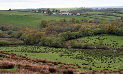
An elevated, open landscape with long views to Dartmoor and/or to Exmoor. Within the patchwork of pastoral fields are extensive areas of rough Culm grassland and heathland. These Culm ‘moors’ have a strong sense of remoteness, even wildness, which is accentuated by the relative lack of settlement and the wind-sculpted trees and hedgerows; they give an impression of how large areas of Devon might have looked before agricultural improvements such as drainage, ploughing and fertilizers. The presence in the landscape of numerous clusters of prehistoric barrows adds to this sense of history and changelessness. The strong textures of plantations, beech hedgerows, heathland and grasses contrast with the smooth improved agricultural land which surrounds them. Patches of colour in the landscape change with the seasons – golden, brown and green grasses, purple heather and bright yellow gorse.
Context
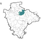
This area comprises elevated land between the Taw Valley (to the west) and the Cruwys Morchard Wooded and Farmed Valleys and the Exe Valley (to the east). To the north is a gradual transition into the South Molton Farmland, and to the south a gradual transition to the lower and more intensively-farmed Crediton Rolling Farmlands.
Constituent Landscape Character Types
| Constituent LCTs: | 1F: Farmed Lowland Moorland and Culm Grassland, 3A: Upper Farmed and Wooded Valley Slopes, 3G: River Valley Slopes and Combes, 3H: Secluded Valleys, 5D: Estate Wooded Farmland |
|---|---|
| Part of NCA: | 149: The Culm |
Distinctive Characteristics
- Underlying Culm Measures geology of mudstones and siltstones with bands of sandstone, supporting poorly-drained soils.
- A gently rolling topography comprising a series of east-west ridges cut by valleys (some of which are included within neighbouring character areas).
- Numerous streams, fed by springs and bogs, flowing through shallow valleys into the wider tributary valleys of the Taw and Exe.
- A relatively well-treed landscape, with linear broadleaved woodland in valleys; patches of plantation on higher ground; pockets of scrub on unimproved grasslands, and strong patterns of hedgerow trees (mostly beech).
- Generally pastoral (sheep and cattle) on medium to poor quality soils; rough grazing on unimproved Culm grassland and heath; red deer are also a distinctive feature of the area.
- Complex field patterns, including areas of small, irregularly shaped medieval fields (e.g. around Creacombe and Rackenford) and other areas of post-medieval and modern fields, often on higher land.
- Fields bounded by hedgerows and banks, usually beech on higher land, but more species-rich in more intensively-farmed areas; wind-sculpted beech a characteristic skyline feature at the upland edge.
- Extensive Culm grassland habitats of wet heath, rich flushes, valley mires, fen and marshy grasslands.
- Numerous clusters of prehistoric barrows and earthworks in prominent hilltop locations.
- Wooded estate of Rackenford Manor locally influencing the character of the landscape.
- Many historic features within the fabric of the landscape including farmhouses, farm buildings, orchards, manor houses, lanes, tracks, field boundaries, bridges and churches.
- Scattered farms on valley sides (often set back along access tracks) with occasional clustered villages or hamlets in ridge-top positions; square tower of Witheridge church is a local landmark.
- Variety of vernacular building styles, including white/ cream rendered cob or stone walls with slate or thatched roofs.
- Network of steep, narrow lanes, often lined by rushy verges and beech hedges (on higher land) and flower and fern rich hedgebanks (in valleys); straight roads across high ground indicate ancient routes.
- Distinctive white finger-posts at crossroads forming a characteristic feature of these lanes.
- The A361 ‘North Devon Link Road’ cutting through the landscape, bisecting areas of Culm grassland.
- Long views north to Exmoor and south to Dartmoor.
Evaluation
- Special Qualities and Features:
- Northern part of the area visible in the panoramic views southwards from Exmoor National Park, making an important contribution to the setting of the National Park.
- High scenic quality, particularly in the northern part of the area and on the Culm grasslands, which have a similar feel to parts of Exmoor.
- Away from the A361, a landscape with a strong sense of remoteness and a timeless quality – one of the most extensive tranquil areas in Devon, with exceptionally dark night skies.
- Internationally and nationally designated (SAC, SSSI) Culm grassland and heathland habitats, supporting a range of plants, invertebrates (including the rare Marsh Fritillary) and breeding birds.
- Largest remaining area of Culm grassland habitats in Devon at Knowstone Inner and Outer Moors, Hares Down and Rackenford Moor.
- Pockets of ancient woodland (semi-natural and replanted), particularly extensive around Templeton in the southern part of the area.
- Numerous CWSs, including woodland, unimproved grassland and wetland sites.
- Area almost entirely within the North Devon Biosphere Reserve.
- Numerous prehistoric features designated as SMs, including individual barrows, barrow cemeteries, hillforts at Burridge Camp and Berry Castle, and an enclosure at East Kidland Wood Camp, plus a later medieval ringwork castle near Stone Barton, and the churchyard cross at Romansleigh.
- Conservation Area covering the historic cores of Witheridge village, Lapford, Chawleigh and Knowstone.
- Two Moors Way recreational route (linking Dartmoor and Exmoor) crossing the area north-south; public access to common land (including the largest Culm grassland sites).
Forces for Change and Their Landscape Implications:
- Past and Current
- Construction of the A361 across Culm grassland at Hare’s Down and Knowstone Moors and the picnic and service area nearby at Beaples Moor, bringing localised major visual intrusion, loss of tranquility, light pollution, and loss of internationally-important habitats.
- Localised visual impacts from ridge-top settlement expansion at Witheridge and telecommunications mast at Stoodleigh Beacon.
- Past loss and fragmentation of Culm grassland habitats as a result of drainage and improvement of land for agriculture.
- Past planting of coniferous plantations on former areas of Culm grassland.
- Tensions between the requirements of nature conservation (SAC/ SSSI) and traditional farming and commoning practices (agri-environment schemes require tailoring to local conditions).
- Agricultural intensification leading to loss of landscape features such as hedgerows (particularly in the southern part of the area), and occasional large farm buildings such as barns and chicken sheds.
- Farm diversification (often to provide recreation facilities) resulting in the introduction of new elements into the landscape (e.g. pony paddocks, fisheries, caravan sites etc).
- Localised appearance of neglect in some farmland due to ongoing decline in the agricultural economy e.g. overgrown hedges; derelict farm buildings; inappropriate farm building repairs.
- Live applications for wind farms on elevated land.
- Future
- Uncertainty over future levels of agricultural funding, potentially affecting viability of ‘marginal’ farming of the Culm grasslands and moors and management of Culm grassland by commoners.
- Potential future demand for tourism and recreation development leading to increased farm diversification, change in working agricultural landscape and potential increase in traffic levels.
- Continued demand for wind farms, potentially introducing large scale structures into prominent positions in the landscape.
- Potential future demand for other renewable energy sources such as solar arrays, bio-energy crops and domestic-scale schemes which could have a cumulative effect on the built fabric of the area.
- Climate change, potentially affecting weather patterns and growing seasons, potentially affecting Culm grassland habitats (e.g. through increased summer droughts and more rapid scrub growth) and traditional agricultural practices.
- Increased frequency of storms, and new pests and diseases (e.g. Phytophthora) resulting from climate change, potentially affecting trees and woodland.
- Potential demand for increased woodland planting to aid water storage/ filtration, low carbon fuel sources and carbon sequestration.
Strategy
- Overall Strategy:
To protect the landscape’s rural character, rich biodiversity, qualities of tranquillity and remoteness, and the setting of Exmoor National Park. The area’s internationally-designated Culm grassland habitats are well managed and extended to increase their resilience to climate change. The character of the area as a remote, tranquil, working agricultural landscape is retained. The views to and from Exmoor National Park are retained and protected from intrusive development.
Guidelines:
- Protect
- Protect the setting of Exmoor National Park, avoiding the introduction of prominent features into the expansive and unspoilt views from the southern edge of the National Park.
- Protect remaining areas of Culm grassland habitat, resisting any further development which would be detrimental to their appearance or biodiversity value.
- Protect the area’s high levels of tranquillity, dark night skies and sense of remoteness, avoiding insensitively-sited or visually intrusive development.
- Protect the landscape’s sparse settlement pattern; any new development should be carefully sited to respect traditional settlement forms, and be screened with existing or new planting if appropriate.
- Protect vernacular buildings, and respect traditional building styles in the construction of new buildings (whilst incorporating sustainable design).
- Protect and appropriately manage archaeological and historical features within the landscape, repairing or restoring distinctive structures such as white finger posts that contribute to distinctiveness.
- Protect and manage surviving traditional orchards.
- Protect wind-sculpted beech trees and hedgerows on high land, replacing if necessary to ensure their continued presence in the landscape.
- Manage
- Manage farmland and associated features such as hedgerows, retaining the area’s character of a working, agricultural landscape.
- Manage Culm grassland and unimproved grassland areas, including through managed burning and locally-appropriate levels of grazing; encourage farmers and commoners to manage ‘marginal’ land as an integral part of the wider farming regime.
- Manage land in accordance with North Devon Biosphere Reserve guidelines.
- Manage archaeological sites (e.g. through clearance/ suitable levels of grazing), and with sensitive interpretation where appropriate.
- Manage existing plantations for sustainable timber production, increased wildlife value, and recreational use where appropriate.
- Manage woodland using traditional techniques (e.g. coppicing) for age and species diversity.
- Plan
- Plan to expand and link fragmented Culm grassland habitats to increase their biodiversity value and their resilience to climate change.
- Plan for reversion of coniferous plantations to broadleaved woodland or grassland at maturity and felling.
- Explore opportunities to increase the recreational value of plantations.