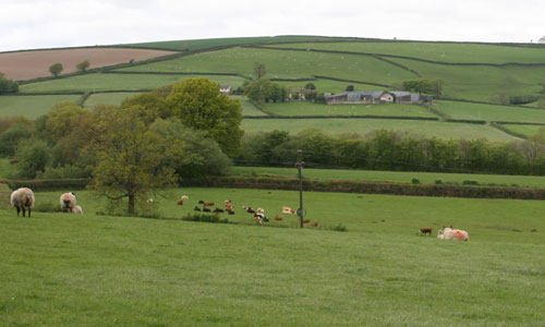
Bright green fields divided by thick dark green hedgerows create a strong patchwork pattern across this peaceful and highly rural landscape. Steep, narrow and ancient lanes and tracks wind across the hills between flower-rich banks and luxuriant hedgerows. South Molton is a thriving market town with a wealth of colourful medieval, Elizabethan and Georgian buildings laid out around its busy main square. The square towers of the churches of South Molton, George Nympton and Bishop’s Nympton are glimpsed between the hills and form important local landmarks.
- Context
 This is a relatively small area, comprising land around the small market town of South Molton, plus the valley of the River Yeo extending eastwards. To the north is a gradual transition to the ridges and wooded valleys of the Exmoor Fringe. To the south is a gradual transition to the lower land of the Taw Valley, with Witheridge and Rackenford Moor beyond and to the east. To the west is the Codden Hill and Wooded Estates, the transition being marked by the edge of the Castle Hill estate.
 - Constituent Landscape Character Types
Constituent LCTs: 1F: Farmed Lowland Moorland and Culm Grassland, 3A: Upper Farmed and Wooded Valley Slopes, 3C: Sparsely Settled Farmed Valley Floors, 3H: Secluded Valleys Part of NCA: 149: The Culm - Distinctive Characteristics
- Underlying Carboniferous Culm Measures (mudstones and siltstones with bands of sandstone).
- Strongly undulating landform of rolling hills cut by spring-fed tributary streams of the River Taw.
- Linear woodland in river valleys and along streams, scattered copses throughout, and a more extensive area of coniferous plantation to the west of South Molton.
- Small traditional orchards often associated with farmhouses.
- A pastoral landscape on medium-quality soils, with occasional fields of arable on better quality land.
- Fields generally fairly regular in shape, but with pockets of older enclosures which are smaller and less regular; fields and lanes bounded by thick species-rich hedgerows with flower-rich banks.
- Semi-natural habitats including pockets of Culm grassland, woodland, and damp grassland.
- Prehistoric hillforts occupying prominent locations in the landscape; other historic features (e.g. bridges, tracks and former mills in the Yeo valley remaining in everyday use, lending a time-depth.
- Market town of South Molton the principal settlement, with smaller villages of Bishop’s Nympton and George Nympton containing square church towers which are local landmarks.
- Scattered farms (often down access tracks) often displaying the local vernacular of whitewash or white/ cream render with painted woodwork and slate roofs.
- Except for the A361 trunk road through the north of the area, roads and lanes that are narrow and winding with white finger-post signage, enclosed by high hedgebanks often rich in flowers and ferns.
- A peaceful and highly rural landscape, with sudden and unexpected long views through gaps in hedgebanks.
Evaluation
- Special Qualities and Features:
- High scenic quality and a quintessentially rich Devon landscape of fields and hedgerows.
- Visible in views to and from Exmoor National Park, contributing to its setting.
- Locally-high levels of tranquillity, although South Molton and the A361 reduce the tranquillity of the northern part of the area.
- Pockets of ancient semi-natural woodland on valley sides, plus larger areas of replanted ancient woodland and CWSs including wetland, grassland and woodland sites.
- Entire area within the North Devon Biosphere Reserve.
- Medieval settlement of South Molton, containing fine medieval, Elizabethan and Georgian buildings; historic core designated a Conservation Area.
- Further Conservation Area at Bishop’s Nympton, plus historic buildings throughout the area.
- Prehistoric hillforts at Whitechapel Moors and north-west of Woodhouse designated as SMs.
- Network of historic lanes and tracks (plus some public rights of way) enable access into the landscape.
- Disused railway line along Yeo valley has the potential to be reopened as a recreational route.
Forces for Change and Their Landscape Implications:
- Past and Current
- Agricultural intensification and farm amalgamation changing the character of the rural landscape (e.g. by conversion of pastoral land to arable use, and construction of large-scale agricultural buildings).
- Establishment of coniferous plantations (e.g. Whitehill Plantation, South Hayne Plantation, Blasridge Plantation) introducing new elements into the landscape.
- Construction of large-scale industrial buildings around South Molton, such as the Norbord factory and the industrial estate adjacent to the A361 which are visible from the surrounding landscape.
- The A361 ‘North Devon Link Road’ cutting across the landscape, with its associated structures such as roundabouts and bridges.
- Light spill – and a reduction in tranquillity – from South Molton and the A361.
- Introduction of vertical features into the landscape, including pylons and telecommunications masts.
- Invasive water-borne weeds (e.g. Himalayan Balsam; Japanese Knotweed) affecting native riparian vegetation and habitats.
- Future
- Uncertainty over future agricultural grants and funding bringing potential changes in farming practices (e.g. alterations in livestock numbers; increased farm diversification) and lack of management of landscape features such as hedgerows and linhays.
- Gradual erosion of landscape character as a result of incremental change e.g. introduction of unnecessary intrusive road signs; insensitive highways works on rural lanes; abandonment of traditional farm buildings.
- Development pressure, due to the continued expansion of South Molton and surrounding industrial estates, changing the character of the town and impacting visually on the surrounding landscape.
- Continued demand for renewable energy schemes, particularly highly-visible wind turbines on elevated land; and new bio-energy crops and solar arrays potentially altering the pattern and appearance of the agricultural landscape.
- Domestic-scale renewable energy schemes with a potential cumulative impact on the historic built fabric of the area.
- Climate change, potentially affecting seasonal weather patterns and growing cycles and bringing new pests and diseases, affecting traditional agriculture and semi-natural habitats such as Culm grassland.
Strategy
- Overall Strategy:
To protect the landscape’s scenic quality and rural character and the local setting of Exmoor National Park. The continued agricultural use of the area is supported, with features such as hedgerows being well managed. Historic features such as lanes, tracks, bridges and finger posts are retained and repaired. Visually-intrusive large scale development is resisted. The development of South Molton is carefully considered to minimise the visual impact on the surrounding landscape, and the historic character of its town centre is retained. The biodiversity of the area is enhanced.
Guidelines:
- Protect
- Protect the setting of Exmoor National Park, avoiding the introduction of prominent features into the expansive and unspoilt views from the southern edge of the National Park.
- Protect the historic character of the landscape, and try to integrate modern large-scale features such as roads and barns through well-designed screen planting.
- Protect and manage surviving traditional orchards.
- Protect rural lanes and tracks and their associated hedgebanks, resisting unnecessary signage and insensitive highways measures.
- Protect historic features such as white finger posts, bridges, farmhouses and agricultural buildings.
- Protect the historic character of South Molton town centre.
- Manage
- Manage farmland, keeping features such as hedgerows and hedgebanks in good repair.
- Manage plantations to maximise their biodiversity, and encourage sustainable timber production.
- Manage remnant areas of semi-natural habitats such as Culm grassland and wetlands though appropriate levels of grazing, and encourage farmers to manage areas of ‘marginal’ land within their wider farming regime.
- Manage in accordance with North Devon Biosphere Reserve guidelines.
- Manage archaeological sites, through clearance and low-level grazing if necessary, allowing visitor access and interpretation if appropriate.
- Plan
- Plan to extend and re-link remnant areas of semi-natural habitats to enhance wildlife corridors and increase resilience to climate change.
- Plan to revert plantations to broadleaved woodlands and grassland habitats on maturity and felling.
- Plan the future development of South Molton to ensure that it is well sited and integrated into the surrounding landscape, including green infrastructure links.
- Plan to ensure that any new developments in the landscape (particularly large structures) are sensitivity designed and sited.
- Plan to investigate the possibility of reopening the disused railway line along the Yeo Valley as a recreation route.