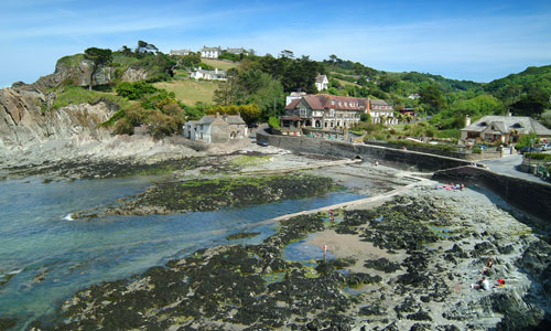
This is an area of spectacular seascapes, with a rugged, jagged coastline containing a series of rocky headlands and small coves with grey shingle beaches. The western part of the area has a remote and ancient feel, with extensive areas of colourful coastal heath and grassland containing prehistoric standing stones. The area around Ilfracombe is more developed, its imposing Victorian architecture telling the story of its rise as holiday destination. The enclosed, wooded coastal combes (each with its own unique character) cut through rolling, agricultural downland to the sea. Trees are prominent features which soften the windswept landscape of the open downland below the ridge tops.
- Context
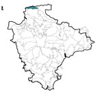
 This area comprises the north-facing coastline around Ilfracombe. To the east is the boundary with Exmoor National Park (outside the remit of this study) and to the south is a gradual transition into the North Devon Downs. To the south-west is the North Devon Coastal Downs. The boundary between the North Devon High Coast and the North Devon Coastal Downs is marked by the change in the aspect and orientation of the coastline.
 - Constituent Landscape Character Types
Constituent LCTs: 4C: Coastal Slopes and Combes With Settlement, 4H: Cliffs, 5C: Downland, 7: Main Cities and Towns Part of NCA: 145: Exmoor - Distinctive Characteristics
- Underlying geology (exposed at the coast) of hard Devonian shales and sandstones, with banks of fossil-rich limestone.
- Dramatic and distinctive seascapes with a rugged coastline of jagged headlands and small bays of grey shingle and views across the Bristol channel to the South Wales Coast.
- Deep, steep-sided, branching combes with fast-flowing streams, separated by broad, rounded ridges of agricultural land.
- Range of types and patterns of woodland within the combes, including ancient oak woodland, plantation, and more open woodland interspersed with grassland or heath.
- Agricultural land generally of medium quality on higher land in pastoral use, with occasional arable.
- Field patterns generally older and less regular on valley sides; more recent and rectangular on higher land indicating late enclosure of downland.
- Valley fields generally enclosed by high hedgebanks (often slate-faced), with wind-sculpted beech and gorse hedgerows on higher ground.
- Herringbone patterns of slates common in walls and hedgebanks; local Morte slates and quartz boulders are distinctive vernacular features in buildings and walls around Lee.
- Fossilised medieval strip-field patterns, especially around Combe Martin, giving landscape time-depth.
- Extensive semi-natural habitats, including cliffs, coastal grassland and heath, inter-tidal mudflats (Watermouth Bay) and species-rich rocky foreshore, much of which is inaccessible.
- Farmland habitats including hedgerows and hedgebanks, field margins and unimproved or semi-improved grasslands.
- Numerous prehistoric sites, including standing stones and coastal hillforts.
- Historic features such as harbours still very much part of today’s working landscape; remains of former important lead and silver mining industry around Combe Martin.
- Linear settlements in sheltered combes, some with harbours; scattered farmsteads on valley sides.
- Local vernacular characterised by variety of styles using cob, Morte slate, thatch, whitewash and stone.
- Fine examples of Victorian seaside architecture in Ilfracombe; Arts and Crafts style houses at Lee; and mining and industrial buildings at Combe Martin.
- Narrow lanes with high, fern-lined banks lending framed views of the sea on descent into the combes; sunken lanes are a particular feature around Combe Martin.
- High land of Exmoor forming a backdrop to views in the eastern part of the area.
- A popular tourist destination, with caravan parks and car parks prominent features in the landscape.
Evaluation
- Special Qualities and Features:
- Exceptionally high scenic quality, largely within the North Devon Coast AONB and Heritage Coast; eastern part of the area also forms the setting to Exmoor National Park.
- Entire area within the North Devon Biosphere reserve.
- High levels of tranquillity in the western part of the area.
- Geological SSSIs, including the only formations of aragonite crystals in the UK at Napps Cave.
- Coastal RIGS, covering geological exposures at Tunnel Beach, Blythes Cove and Rapparee Cove.
- Extensive areas of CWS including ancient woodland in combes, coastal heathland, unimproved grasslands and wetland areas.
- Prehistoric standing stones around Lee and Hillsborough promontory fort designated SMs.
- Conservation Areas in Berrynarbor, Lee and Ilfracombe town centre; and numerous listed buildings, including early farmhouses, agricultural and industrial buildings.
- Stone church towers of Combe Martin and Berrynarbor that form local landmark features.
- Numerous designated wreck sites lie just off the treacherous coastline.
- LNR at Hillsborough, an accessible coastal heathland site just outside Ilfracombe.
- Extensive areas of National Trust land in the western part of the area (Morte Estate, Lee Estate and Torrs Park Estate).
- Good public right of way network, including the South West Coast Path along the cliff tops.
Forces for Change and Their Landscape Implications:
- Past and Current
- Tourism-related development of the coastline east of Ilfracombe – harbours, villages, the coast road, golf course and numerous car parks and caravan sites.
- Erosion and recreation pressure around coastal resorts, on South West Coast Path and other paths.
- Extensive modern housing development around Ilfracombe prominent in the landscape.
- Linear housing extending along roads around Berrynarbour changing the undeveloped character here.
- Increased levels of traffic (particularly in summer) affecting the character of quiet, narrow rural lanes.
- Superfluous and visually-insensitive road signs bringing incremental change to landscape quality.
- Light spill from Ilfracombe and other settlements outside the area resulting in loss of dark night skies.
- Telecommunications masts on prominent hill summits, detracting from the smooth, open skylines of the downland ridges.
- Past loss of pastoral land to arable use; and loss of habitats and landscape features such as unimproved grassland, hedgebanks and hedgerows to agricultural improvement.
- Past loss of coastal grassland and heath to scrub due to changes in grazing practices.
- Farm diversification schemes (e.g. quad biking, equine business, campsites) that add to new elements to the landscape.
- Division of farms, and amalgamation into larger holdings, changing the traditional appearance of the landscape, e.g. through the construction of large agricultural buildings.
- Past planting of conifers in combes, particularly in the Sterridge and Borough valleys.
- Consented large on-shore wind farm at Fullabrook Down, which will be visible from this area.
- Future
- Population growth and continued demand for development (particularly around Ilfracombe and Combe Martin) potentially affecting the traditional character of settlements.
- Continued demand for tourism-related development (including expansion of holiday camps and increased numbers of permanent buildings in sites) resulting in further incremental loss of landscape character.
- Potential effects of the future expansion of Ilfracombe Harbour on the setting of Hillsborough Hillfort.
- Changes in seasonal weather patterns and the introduction of new species, pests and diseases (e.g. Phytophthora) resulting from climate change, potentially affecting semi-natural habitats such as woodland and heath, as well as agricultural practices.
- Higher sea level and storm frequency as a result of climate change leading to increased coastal erosion. Shoreline Management Plan recommends ‘no active intervention’ along much of this stretch of coast (although sea defences at Lee, Ilfracombe, Watermouth and Combe Martin will be retained), potentially causing ‘coastal squeeze’ between the eroding shoreline and agricultural land behind.
- Uncertainty over future funding of agricultural grants and subsidies, potentially affecting farm viability and the management of characteristic landscape features such as coastal heaths, species-rich grasslands, hedgerows and woodlands.
- Growth in renewable energy sources, including biomass crops, offshore and onshore wind farms (including the proposed Atlantic Array), and domestic-scale renewables, which potentially have a cumulative landscape impact.
Strategy
- Overall Strategy:
To protect the distinctive seascapes, high scenic quality and strong sense of place within the North Devon Coast AONB and its setting; and enhance the area’s role as a setting for Exmoor National Park. Enjoyment of the area is encouraged, but tourism-related development is sensitively integrated into the landscape. Sustainable agriculture is supported, and historic landscape features such as field patterns, sunken lanes and archaeological sites are protected and well-managed. Important semi-natural habitats such as woodland and coastal heath are well-managed and strengthened to resist climate change.
Guidelines:
- Protect
- Protect the high scenic quality of the area within (or as a setting to) the North Devon Coast AONB.
- Protect the area as the setting to Exmoor National Park.
- Protect the area’s distinctive and dramatic seascapes.
- Protect open skylines from inappropriate development.
- Protect settlement forms, resisting further spread or coalescence of settlements.
- Protect traditional building styles and materials, ensuring that any new development is sympathetic in form and style, whilst incorporating sustainable design.
- Protect rural lanes, resisting inappropriate signage and unsympathetic highways works.
- Protect ancient woodlands in coastal combes.
- Protect historic features and landmarks such as church towers and strip field patterns, to ensure they remain integral parts of the landscape.
- Manage
- Manage visitor pressure at sensitive sites to minimise erosion of headlands and path; maintain paths in a good state of repair where possible.
- Manage archaeological sites, controlling visitor pressure and providing sensitive interpretation where appropriate.
- Manage, sustain and support agricultural use, increasing the biodiversity of farmland, providing incentives for farmers to graze ‘marginal’ land such as unimproved grassland and coastal heath as an integral part of their farming systems.
- Manage hedgerows and replace lost or over-mature hedgerow trees and wind-sculpted tree belts; restore lost field patterns where possible.
- Manage the land within the North Devon Coast AONB and North Devon Biosphere Reserve in accordance with the AONB’s statutory duties and the guidelines of the Biosphere Reserve.
- Manage and re-link woodlands, encouraging the use of traditional techniques such as coppicing, and retaining the diversity of woodland types within the area.
- Manage areas of plantation to enhance biodiversity.
- Manage and re-link semi-natural coastal habitats to maximise their biodiversity and strengthen their resistance to coastal squeeze and/ or climate change. Restore and develop areas of coastal heath and create buffer zones between cliff communities and improved agricultural land where possible.
- Plan
- Plan to explore sustainable travel options to reduce road traffic during busy holiday periods.
- Plan to create green infrastructure links to and from coastal resorts and the South West Coast Path to facilitate recreation, reduce car usage and enhance the natural settings of settlements.
- Plan to encourage the reversion of plantations to broadleaved woodland or grassland habitats on maturity and felling.
- Plan for the future effects of climate change along the coast, allowing natural processes to take place as much as possible, whilst ensuring local people are involved in decision-making relating to future landscapes.
- Plan to reduce light pollution from roads and settlements and increase the darkness of night skies.