Lundy is an isolated and unique place, surrounded by and dominated by the ever-changing sea. Remote and undeveloped, it is a ‘sanctuary’ away from the mainland. Its seascapes are dramatic, with sheer cliffs rising out of the water, battered into dramatic shapes by the force of the Atlantic breakers. The desolate, windswept moorland is alive with the sounds of crashing waves and the cries of the sea birds. The island’s remoteness from 21st century life, and its sense of changelessness, is enhanced by the extraordinary richness of its history. This historic sites provide a tangible link with the island’s past, stretching as far back as prehistoric times.
- Context
 Lundy is a small island (approximately 1km by 5km) located around 18km off the North Devon coast in the Bristol Channel.
 - Constituent Landscape Character Types
Constituent LCTs: 6: Offshore Islands Part of NCA: 159: Lundy - Distinctive Characteristics
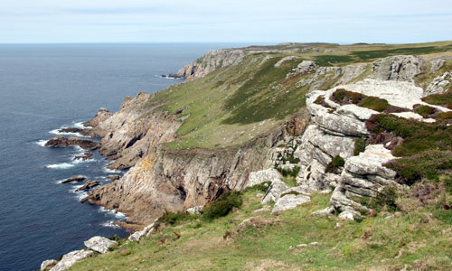
- A flat-topped island formed primarily of Tertiary granite, with Devonian slates revealed along the south-east peninsula; intrusions by vertical dykes reveal the island’s volcanic past.
- West coast with spectacular cliffs reaching over 100m battered by Atlantic winds and waves resulting in a rugged, exposed coastline with features including the Devil’s Limekiln sea-cave and the Devil’s Chimney; eastern coast more sheltered, with vegetated slopes and secluded rocky coves.
- Plateau drained by a series of small streams cascading down the cliffs and flowing to the sea; small ponds (the most significant at Pondbury) forming valued wetland habitats.
- Exposed west coast and plateau defined by an absence of tree cover, while stunted stands of oak and sycamore are associated with the sheltered south-east coast.
- Brown podzol soils giving rise to impoverished, acidic conditions across the Island.
- Open grazing by feral Soay sheep, goats, Lundy ponies and Sika deer, with limited cultivation of the enclosed farmland; also a large rabbit population (introduced in medieval times).
- Northern half of plateau characterised by unenclosed heathland and acid grassland; in-bye farmland in the centre and south of the island enclosed within grey granite stone walls forming square fields.
- Cliff-top heath and maritime grasslands, supporting unique flora and fauna – including the endemic Lundy cabbage – plus colonies of grey seals and sea birds, including puffins.
- High concentrations of archaeological and historic sites from the prehistoric period to the 19th century, giving a very strong sense of time-depth.
- Village clustered at the sheltered south-east corner of the island; unifying grey granite vernacular also used in other prominent buildings including St. Helena’s church and the early19th century lighthouse (the Old Light); white-rendered manor house is a distinctive feature.
- New jetty and access road snaking along the south-east peninsula linking landing bay with village; remainder of island crossed by one rough track, lined by distinctive granite boulders in its southern stretches.
- Extensive and varied seascapes, including long views to the South Wales and North Devon coasts; in clear conditions there are views to Woolacombe Down, Baggy Point and Saunton Down, with the lighthouse at Hartland Point forming a distinctive feature on the horizon.
- Special Qualities and Features:
- Island owned by the National Trust, leased to and managed by the Landmark Trust and designated Heritage Coast.
- Important seascape feature visible from all along the North Devon coast, the church tower and old lighthouse forming prominent vertical elements above the plateau; the appearance and clarity of the island varies markedly in different weather conditions.
- Island at the mercy of the elements, and defined by the ever-present influence of the sea – offers a challenging and exhilarating ‘wilderness’ experience to visitors from the mainland.
- Very high levels of tranquillity and dark night skies across the whole island.
- Entire Island is within a North Devon Biosphere Reserve, and is also a marine NNR for its maritime habitats, and seal and sea bird colonies; most non-farmland also designated SSSI.
- Coasts and surrounding seas of the island are SAC for their outstanding offshore reef system.
- Over 40 SMs covering ritual, industrial and defensive sites such as Bronze Age burial mounds; early Christian inscribed standing stones; remains of the 13th century Maresco Castle and 19th century quarries and gun emplacements; to the east of the islands are two Protected Wreck sites.
- Informal paths (with no signposting) and extensive access land enabling visitors to explore the island.
- A unique cultural identity defined by a small close-knit working community, far removed from 21st century influences and with strong senses of isolation, self-sufficiency and spirituality.
 Lundy is a small island (approximately 1km by 5km) located around 18km off the North Devon coast in the Bristol Channel.
Evaluation
Forces for Change and Their Landscape Implications:
- Past and Current
- Fluctuations in numbers of grazing animals (as a result of changing agricultural policies) resulting in episodes of overgrazing by sheep, goats and deer; rabbit numbers are often also very high, although occasionally knocked back to very low levels by myxomatosis.
- Spread of rhododendron, particularly along the east coast, affecting the island’s biodiversity; all mature bushes have now been removed, with eradication planned through follow-up controls and seedling removal.
- Use of fencing – rather than traditional granite – to repair stone walls, changing landscape character.
- Visitor pressure (up to 20,000 visitors per year) and resultant erosion of popular walking routes.
- New access road from the quay to the village (required because cliff erosion threatened the old road) – a prominent man-made feature on the south-eastern coastline.
- Arrival of some visitors by helicopter impacting on tranquillity.
- Future
- Potential increases in visitor numbers, requiring additional infrastructure on the island, and leading to increased erosion problems.
- Potential reduction in numbers of grazing animals (as a result of uncertainly over agricultural funding and support) leading to loss of coastal grassland and heathland habitats and their associated species.
- Potential sea level rise and more rapid coastal erosion as a result of climate change, leading to cliff instability, more frequent landslides, the ‘squeeze’ of coastal habitats and potential loss of cliff-top archaeology, as well as the potential future erosion of the landing quay and access road.
- Potential impacts of climate change on the island’s unique habitats and species, including an increased prevalence of pests, diseases and invasive species.
- Demand for off-shore renewables, particularly wind farms and tidal devices – notably the proposed ‘Atlantic Array’ offshore wind farm which could affect views northwards from the island.
Strategy
- Overall Strategy:
To protect the wild, exposed and generally unsettled character of Lundy, ensuring that any new development does not detract from these valued attributes. The island’s geology, cultural heritage and biodiversity are protected, celebrated and appropriately managed, and are able to meet the future challenges presented by climate change. People can continue to visit and enjoy the island, appreciating and understanding its historic character and the dynamic nature of the coast, without detriment to its habitats.
Guidelines:
- Protect
- Protect the largely undeveloped, open and isolated character of Lundy.
- Protect the island’s dramatic seascapes, with their expansive views across the open sea to the North Devon and South Wales coasts.
- Protect the island’s special role in as a seascape feature in views from the sea and from the North Devon coast, with Old Light and St Helena’s church tower standing out as landmark features.
- Protect the characteristic vernacular of buildings constructed from grey Lundy granite, ensuring building repairs and restoration are sympathetically undertaken using the same materials and building styles where possible. Keep visitor signage and infrastructure to a minimum to protect the island’s special character.
- Protect, sensitively manage and – where appropriate – restore the landscape’s rich and varied archaeological heritage, including through the careful monitoring of grazing and access levels.
- Protect the ecologically-rich off-shore reefs which surround the island.
- Manage
- Manage the island’s nationally important heathland, maritime grassland and wetland habitats and unique species (such as the Lundy cabbage), ensuring grazing levels by domestic, feral and wild animals are controlled at appropriate levels.
- Manage (and restore where necessary) the distinctive granite stone wall field boundaries around Lundy’s in-bye land, seeking to reinstate lengths where fencing is currently used for stock protection.
- Manage nationally-important coastal habitats, including coastal heath and maritime grasslands, by supporting a continuation of extensive grazing at appropriate levels.
- Manage characteristic areas of stunted woodland in the Millcombe valley and along parts of the east coast, continuing to control and eradicate invasive species such as rhododendron and protecting sensitive areas from grazing damage.
- Manage agriculture on the island, ensuring that the menu at the Tavern continues to strongly feature Lundy produce as an important source of income.
- Plan
- Plan for the impacts of a changing climate on the island’s coastline, allowing natural processes to take place wherever practical. Use existing interpretation spaces (in the Rocket Shed and Beach Hut) to explain how the impacts of climate change are likely to affect Lundy Island and its surrounding seascape.