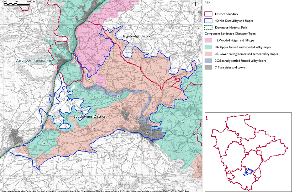
- Constituent Landscape Character Types
Constituent Landscape Character Types:
3A: Upper farmed and wooded valley slopes
3B: Lower Rolling Farmed and Settled Valley Slopes
3C: Sparsely Settled Farmed Valley Floors
3E: Lowland PlainPart of National Character Area: 151: South Devon
- Contextual description
This area comprises the River Dart and surrounding slopes and hills between the A38 and the foothills of Dartmoor in the west, and Totnes in the east. It is bounded to the south by a marked change to a distinctive landscape of interlocking rounded ridges and incised valleys and to the north by the elevated farmland of Denbury Down.
Summary Description:
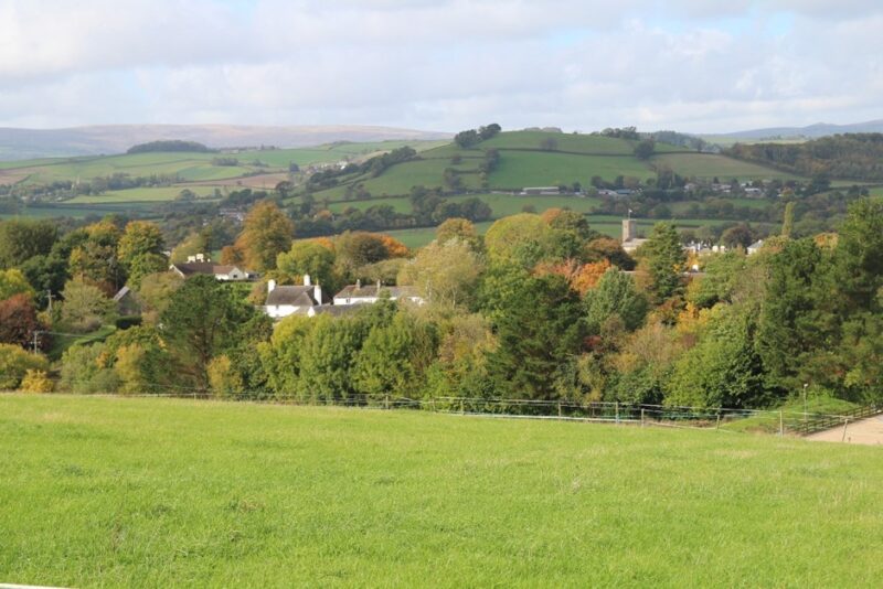
This character area comprises the valley of the River Dart and tributaries, and surrounding rolling hills and slopes. The Dart flows through a winding, frequently wooded, narrow gorge for much of its course, widening to a flood plain and more expansive river with weirs and more gentle slopes, particularly to the north of the river. Its tributaries including the River Hems lie in narrow valleys, enclosed by rounded hills with limited tree cover; the landscape tends to broaden at confluences. Views are obtained across and along the valleys in places, to nearby hills and the rising mass of Dartmoor to the west. However, many views are relatively short and contained, focusing on the rounded hills and rivers which give this area its sense of place. The area is strongly defined by the steep, winding, narrow wooded valley of the Dart and to a lesser extent by its tributaries and surrounding rolling hills. There is a strong sense of tranquillity within the rolling hills and valleys away from settlement and transport infrastructure.
- Distinctive Characteristics
- Landscape underlain by slate, shales and limestone giving rise to a steep sided, winding, narrow river valley and tributary valleys.
- Surrounding rolling hills generally with steep slopes; more gentle slopes to the north with numerous springs.
- Limestone geology evident in occasional disused quarries and limestone walls and buildings.
- Broadleaved and mixed woodland on steep bluffs along the Dart gorge; less-wooded narrow tributary valleys whose streams are often tree lined.
- Good agricultural land quality, resulting in a mixed pattern of pasture and arable in sub-regular medium to large fields enclosed by dense hedgerows.
- Semi-natural habitats that include river and stream corridors, mixed and broadleaved woodland, hedgerows and mature trees.
- Historic bridges and occasional old mills which act as focal points; historic railway along the Dart.
- Occasional old orchards and small parks associated with historic house.
- Settlement pattern of scattered houses, farms, hamlets and nucleated villages, frequently with limestone or render and slate vernacular buildings, as well as some cob and thatch and brick and tile; historic town of Totnes.
- Network of winding, enclosed, narrow lanes with some main roads crossing and fringing the landscape.
- Mainline railway following parts of the tributaries, with major power lines dominating in places.
- Strong sense of tranquillity, reduced locally close to main roads and railway.
- Views across and along valleys to nearby hills and towards Dartmoor.
Evaluation
- Special Qualities and Features
- High scenic quality in many places within the wooded valley of the Dart and in sparsely developed parts of the more open tributaries and rolling hills.
- Strong sense of tranquillity away from settlement and transport networks.
- Significant areas of ancient woodland along the River Dart, SSSI and RIG sites associated with the limestone geology particularly in the north of the area, and SSSIs associated with grassland and woodland.
- Historic town of Totnes, a significant part of which is a Conservation Area.
- Wealth of cultural heritage features, including Dartington Hall Historic Park and Garden and SM associated with former deer park; hilltop enclosures (hillfort overlooking the river); historic settlements such as Little Hempston; and numerous mills and stone bridges.
- South Devon Steam Railway, which passes through this landscape along the valley floor and is a key visitor attraction.
- River Dart and associated wildlife, natural elements and riverbank paths offering tranquil routes and places accessible from Dartington and Totnes.
Forces for Change and Their Landscape Implications
- Past and Current
- Major power lines dominating the Hems and Am tributary valleys and a sub-station at Bumpston Cross undermining scenic quality.
- Tranquillity undermined locally by transport infrastructure including the A381 and A384, A38 and mainline railway.
- Hedgerow removal particularly in areas of gentle slopes and mixed farming in the drive for agricultural intensification.
- 20th century farm amalgamation and modernisation, with large farm buildings often occupying prominent locations.
- Decline in woodland structure and diversity due to lack of appropriate management and planting of small conifer woods affecting the pattern of the landscape and diversity of ancient woodland sites.
- Pressure for recreation and increase in number of facilities and attractions including craft centres, caravan and camping sites and holiday accommodation.
- Sewage works development within the Hems valley associated with Totnes, affecting the character and quality of the valley adjacent to the settlement.
- Pressure for new solar farms and masts.
- Need for farms to have slurry tanks in response to new waste management regs – increasing industrialisation of farmsteads.
- Future
- Pressure for new masts, wind turbines and pylons, which would be potentially highly visible on prominent skylines.
- Pressure for new solar farms which could have a very high visual impact on valley slopes
- Demand for domestic and community-scale renewable energy installations such as solar panels, small wind turbines and ground-source heat pumps – leading to incremental change to traditional buildings.
- Construction of large extensions to existing dwellings and new buildings in high visibility locations on hilltops and open slopes, resulting in visual intrusion and erosion of vernacular character.
- Conversion of traditional agricultural buildings and attached land for domestic and leisure use, which can lead to unsympathetic boundary and surfacing treatments and erosion of rural character, and increase the need for new agricultural buildings elsewhere.
- Potential agricultural intensification, which may lead to loss of traditional field boundaries and old orchards; change to existing landscape patterns; and introduction of polytunnels.
- Construction of new, large-scale agricultural buildings, which can be out of scale with existing traditional, smaller-scale buildings and industrial-style slurry tanks that are potentially not in scale and character of traditional farmsteads.
- Widening and new access points to narrow lanes, eroding their rural character.
- Increase in domestic tourism with associated demands for new facilities and infrastructure as well as an increase in traffic levels on rural roads.
- Change in crops and land use as a consequence of climate change and response to changing markets (e.g. bio-energy crops such as Miscanthus).
- The change /transition to the new land management system (ELMS) promises to be positive for the environment- more so than the CAP- and offers opportunity to strengthen landscape features and characteristics.
- Need for landfill/landraising within construction sites and modification of natural topography.
- Need for attenuation basins as part of SuDS as a requirement of new development.
Strategy
- Overall Strategy
To protect the distinctive and dramatic wooded gorge of the River Dart and the rural character of its tributaries and farmland setting. New development reflects the small scale, historic settlement pattern and vernacular character and conserves views across and along valleys. The landscape pattern of mixed pasture and arable fields with hedgerows, narrow lanes and woodland is conserved and enhanced and opportunities for green infrastructure links to settlements and appropriate recreation developments are sought.
Guidelines
- Protect
- Protect important views to and from the hills across the surrounding landscapes, including views to Dartmoor.
- Protect the landscape’s strong sense of tranquillity, resisting highway improvements and lighting schemes that would affect these special qualities.
- Protect the sparse settlement pattern of houses, farms, hamlets and small nucleated villages.
- Prevent the linear spread of development along river valleys and roads wherever possible, to maintain the settlements’ characteristic form and peaceful character. Utilise the woodland cover and topography to filter views of any new development.
- Protect traditional building styles and materials, particularly the use of limestone, reflecting these in new development wherever possible (whilst seeking to incorporate sustainable design).
- Protect and restore historic features within the valleys, particularly those relating to the rivers’ industrial heritage such as mills, dismantled railways and bridges.
- Protect the landscape’s network of quiet lanes enclosed by woodland and species-rich hedgebanks, resisting unsympathetic highways improvements or signage.
- Manage
- Manage and enhance the valleys’ semi-natural woodlands through traditional techniques, including coppicing, and control access by livestock to promote natural regeneration. Use extensive grazing to promote the species diversity of woodland ground flora.
- Explore opportunities for community utilisation of coppice residues as a low-carbon fuel source.
- Manage and enhance the field patterns, restoring lost and gappy Devon hedgebanks using traditional methods and styles of construction, including stone facing on banks using local materials wherever possible.
- Manage and enhance the wildlife interest of the farmed landscape, including through the creation of species-rich grass buffers around arable fields (also serving to reduce agricultural run-off).
- Within the valleys, manage and extend species-rich meadows and floodplain grasslands through appropriate grazing and traditional land management regimes – both to enhance their wildlife value and function as flood prevention.
- Manage areas of semi-natural habitat. Link and extend habitats where possible to increase biodiversity, contribute to nature recovery networks and provide suitable habitats for flora and fauna.
- Plan
- Create, extend and link woodland and wetland habitats to enhance water storage capacity, reducing soil erosion, agricultural run-off and downstream flooding and improving water quality.
- The natural regeneration of woodland and new planting (using climate-hardy species) to link fragmented sites.
- Minimise soil erosion and reduce diffuse pollution by replanting of former hedgelines particularly along slopes to minimise soil erosion and reduce diffuse pollution.
- Restore and manage areas of relict traditional orchards and explore opportunities for the creation of new ones, including community orchards to promote local food and drink production.
- Plan for a network of green spaces and green infrastructure links to support future population growth in Totnes, integrating development into the landscape and providing for local access and recreation.
- Plan for the development of community-based renewables including wind turbines, solar arrays and ground source heat pumps, paying particular regard to cumulative impacts.
- Plan to mitigate climate change impacts allowing natural process to take place where possible.
- Plan a landscape-led response to the UK-wide policy drive for increased tree and woodland planting, implementing Devon Local Nature Partnership’s ‘Right Place, Right Tree’ principles to create a balance of climate-resilient native species appropriate to the local landscape.
- Plan to contribute to nature recovery networks and provide suitable habitats for flora and fauna.
- Plan for the sensitive location of new development, avoiding locations visible from sensitive locations within 5km of Dartmoor National Park.
- Plan for new slurry tanks to be grouped with other farm buildings, recess into ground, use natural topography and trees for screening and integration and sensitive colour treatment with dark recessive colour to minimise visual impact.
- Plan for landfill/landraising of development sites and modification of natural topography by designing new landform in character with topographic context, avoid artificial engineered landforms, and integrate into the landscape.
- Plan for attenuation basins as part of SuDS required as part of development designing for biodiversity and amenity enhancement, where possible to enhance development not just provide engineering function.