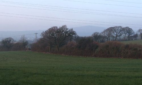
The constant presence of Dartmoor on the northern horizon is a defining characteristic of this area. Situated below the open skyline, moorland rim and wall-patterned upper slopes of Dartmoor, this landscape forms a patchwork of fields, small woodlands and some estate planting. Together they create a settled, well-treed and scenic landscape. Despite the presence of the A38 and the town of Ivybridge, the area’s narrow wooded valleys retain an intimate and secluded character, with tree-lined rivers snaking through a pastoral landscape of meadows, woodland and estate parkland.
- Context
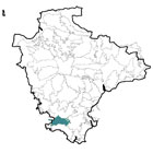
 This area is located to the east of Plymouth, and includes the town of Ivybridge. To the north is a gradual transition up to Southern Dartmoor and Fringes and to the south a transition to the Bigbury Bay Coastal Plateau; while to the east and west respectively lie the Mid Avon and West Dart Valleys and Ridges and the built-up area of Plymouth. The area includes the middle catchments of the Rivers Erne and Yealm and is crossed by the A38.
 - Constituent Landscape Character Types
Constituent LCTs: 3G: River Valley Slopes and Combes, 3E: Lowland Plains, 3B: Lower Rolling Farmed and Settled Valley Slopes Part of NCA: 151: South Devon - Distinctive Characteristics
- Mainly underlain by mid Devonian rocks (mudstone and slate with limestone and sandstone) with extensive intrusions of basaltic lava and tuff; fault line between mid and late Devonian rocks near the northern boundary of the area.
- Gently rolling landform forming an irregular pattern of low hills and valleys.
- Rivers Erme, Yealm, Silverbridge Lake and Lud Brook flowing generally north-south from Dartmoor to the sea along pronounced valleys with flat valley floors; smaller tributary streams in shallower valleys.
- Deciduous woodland in valleys, with occasional blocks of deciduous or coniferous plantation on higher land; numerous smaller woodlands, copses, riparian and hedgerow trees (particularly oaks) enhancing the well-treed appearance of the landscape.
- Medium to poor soils, mainly supporting pastoral agriculture, with some pockets of arable; scattered orchards throughout the area.
- Fields generally medium in size and semi-regular in shape, with areas of smaller and less regular fields – representing earlier enclosures – surviving around some villages.
- Large block of surviving medieval enclosures in the central part of the area, and extensive ‘Barton’ fields (dating from 15th to 18th century) to the south and east of Ugborough.
- Fields divided by wide hedgerows with those around arable fields tending to be more closely flailed than those around pasture.
- Semi-natural habitats including woodland, wetland and unimproved grassland.
- Several estates, with parkland locally influencing landscape character (e.g. around Lyneham, Flete, and Strode) and occasional hilltop clumps forming landmarks.
- Numerous historic features within the landscape including lanes, tracks and stone bridges.
- Scattered settlement pattern of dispersed farmsteads and villages, often constructed of stone.
- The larger settlements of Ivybridge, Modbury and Yealmpton situated along the main roads which run east-west across the northern and southern edges of the area.
- Network of winding lanes, often sunken, with outward views frequently barred by high hedgebanks and contrasting major road of A38.
- Secretive, intimate valleys contrasting with the surrounding more open farmland.
- Rim of Dartmoor providing an important northern backdrop and strong sense of place.
Evaluation
- Special Qualities and Features:
- Parts have high scenic quality and a key role as part of the setting of the South Devon AONB.
- Dominated by Dartmoor on the northern horizon, strongly influencing the character of the area; visible in views to and from Dartmoor, contributing to the setting of the National Park.
- Sense of remoteness, particularly within river valleys.
- Ancient woodlands, often in linear form along valley sides.
- Diversity of CWSs, including ancient semi-natural woodland, secondary woodland, a large lake and swamp, marshy grassland and neutral grassland.
- Several RIGSs, displaying various geological features including fossils; folded rocks; intrusions of gabbro and volcanic tuff (lava); limestone formations and the margin of Dartmoor granite.
- Northern part of the Flete estate (Grade II on the Register of Historic Parks and Gardens), comprising late 19th and early 20th century gardens and pleasure grounds, within a wider18th century parkland of national significance for wildlife due to its large number of veteran trees.
- Saltram House, Grade II* Historic Park and Garden on the edge of Plymouth, overlooking the tidal estuary of the River Plym.
- National Trust-owned estate (not open to the public) at Ugborough House.
- SM at Lyneham, encompassing Westerbury Camp Iron Age hillfort, medieval deer park (including sections of the park pale) and rabbit warren.
- Several Conservation Areas, reflecting the quality of the area’s built heritage, covering the historic cores of Ugborough, Ivybridge, Modbury, Yealmpton and Ermington.
- Erne-Plym Trail recreational route running through the area.
Forces for Change and Their Landscape Implications:
- Past and Current
- Visual and audible impact from A38 reducing tranquillity in the northern part of the area.
- Intrusive industrial estates north of the A38 between Plympton and Ivybridge affecting rural character.
- Urban expansion of Plymouth, Plympton and Ivybridge (often with poor quality urban edges) impinging on views.
- Urban fringe influences (e.g. equestrian activity, informal development, road signs etc.) affecting the character of the landscape, which may be exacerbated by poor management of agricultural land (e.g. neglect of hedgerows, poorly-maintained farm buildings etc.).
- Light pollution from Plymouth and A38 corridor resulting in loss of dark night skies.
- Past quarrying activities – lakes and tips remaining features in today’s landscape.
- Localised visual impacts from large structures such as pylons, communications masts etc.
- Past intensification of agriculture, resulting in (for example) drainage and improvement of grassland, field amalgamation and hedgerow loss, and the construction of large farm buildings, glasshouses and polytunnels.
- Past replanting of ancient woodland with coniferous or mixed plantations.
- Threat of new pests and diseases (e.g. Phytophthora) resulting in loss of trees and woodlands.
- Invasive water-borne weeds (e.g. knotweed, Himalayan balsam) resulting in loss of native riparian vegetation and habitats.
- Future
- Development pressure from surrounding settlements resulting in continued urban expansion e.g. Sherford.
- Continued prevalence of urban fringe activities, with gradual erosion of the condition of the landscape.
- Uncertainty over future levels of agricultural grants and funding, potentially affecting livestock numbers and maintenance of landscape features such as hedgerows and historic farm buildings.
- Tree and woodland loss as a result of increased magnitude and frequency of storm events due to climate change.
- Changes to seasonal weather patterns (e.g. increased summer droughts and winter flooding) potentially resulting in loss of drought- and wet-intolerant species and changes to agricultural practices.
- Demand for new quarries for building stone/ aggregate.
- Demand for renewable energy sources (e.g. wind turbines, solar arrays, hydro-electric plants and biofuel crops) potentially changing the appearance and pattern of the landscape; domestic and community scale schemes may have a cumulative impact on the landscape and built fabric of the area.
Strategy
- Overall Strategy
To protect the landscape’s scenic quality and rural character, and enhance the settings of Dartmoor National Park and the South Devon AONB. Agricultural land is well-managed, and urban fringe influences (including neglect of farmland) are resisted. Woodland, parkland and other semi-natural habitats are well managed. The visual and audible impacts of existing and future urban and road developments are minimised.
Guidelines:
- Protect
- Protect the area’s scenic quality and enhance the settings of Dartmoor National Park and the South Devon AONB.
- Protect the area’s characteristic small woodlands, clumps, copses and hedgerow trees.
- Protect hedgerows and hedgebanks, retaining the ‘patchwork’ appearance of the landscape.
- Protect and manage remaining orchards.
- Protect the sense of remoteness experienced in the area (particularly in river valleys) resisting developments which may compromise this quality.
- Protect historic lanes and tracks, and their associated hedgebanks and bridges, resisting unsympathetic signage or highways measures.
- Protect the area’s settlement pattern and distinctive stone-built traditional buildings, ensuring that any new development is sympathetic in terms of scale, form, style and materials.
- Manage
- Manage agricultural land to enhance its biodiversity; maintain the condition of the landscape, and keep traditional features such as hedgerows in good repair.
- Manage woodland and copses (including through traditional techniques such as coppicing) to maximise age and species diversity, and encourage a diverse ground flora.
- Manage river corridors and their associated wetlands to increase their biodiversity; control and eradicate if possible any invasive water-borne weeds.
- Manage grassland habitats through locally-appropriate levels of grazing.
- Manage parkland, protecting historic features – in particular conserving ancient and veteran trees and providing new generations of open grown trees to ultimately replace them, as well as ensuring extensive pasture management with low stocking.
- Plan
- Plan to ensure that any future urban development is well sited and designed, incorporating screen planting (if appropriate) and suitable green infrastructure links.
- Plan to increase the accessibility of the landscape, exploring opportunities for improving public rights of way, and improving links between the countryside and surrounding settlements.
- Plan to improve the quality of the urban edges of settlements, roads and industrial developments to reduce their visibility from the surrounding countryside.
- Plan to consider the introduction of whisper tarmac on the A38 to reduce traffic noise.
- Plan to reduce light pollution from nearby settlements and roads.
- Plan to restore former quarry sites, reducing their visibility within the landscape, and increasing their biodiversity value.
- Plan to plant new orchards, possibly as community projects.
- Plan to extend and link semi-natural habitats such as woodlands and grasslands to enhance their biodiversity and role as wildlife corridors, and to increase their resilience to climate change.