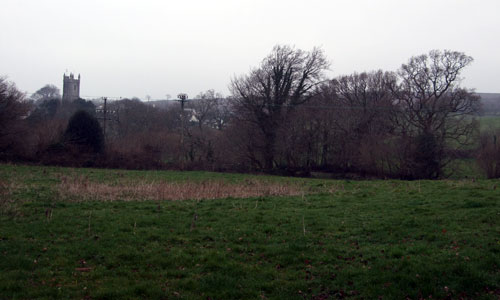
This is a plateau landscape dissected by major rivers (the Avon and tributaries of the Dart) where the interplay of upland and valley is the defining characteristic. Located some distance from the coast (and of a lower elevation than the coastal plateau) the focus of this landscape is inland and from higher ground there is a strong visual association with Dartmoor on the north-western skyline. From the narrow plateau ridges the valleys below have surprisingly little influence on landscape perceptions; within the valleys themselves the landscape is generally enclosed by woodland. There is no definite grain or pattern to the valleys and this contributes a sense of disorientation. Most of this landscape is feels remote and is only lightly settled. The historic lanes, intact villages, church tower landmarks and historic sites contribute a strong sense of time-depth and intactness. Within the sheltered Avon valley the river flows between overhanging trees and there is an air of peace and seclusion.
- Context
 This area covers an extensive part of South Hams District and comprises an elevated inland plateau south-east of Dartmoor which is deeply incised and dissected by valleys. To the north the landscape drops in elevation to lower rolling farmland surrounding Totnes. To the east it is flanked by the distinctive Dart Estuary and tributary creeks and to the south there is a transition to the coastal hinterland of Start Bay and Salcombe to Kingsbridge Estuary, where coastal influences are apparent. To the west there is a gradual transition to the lower-lying, less incised farmlands surrounding Modbury and the rising moorland fringes of Dartmoor.
 - Constituent Landscape Character Types
Constituent LCTs: 5A: Inland Elevated Undulating Land, 3G: River Valley Slopes and Combes, 3A: Upper Farmed and Wooded Valley Slopes Part of NCA: 151: South Devon - Distinctive Characteristics
- A series of east-west geological bands from slate in the north through hard Staddon grits and Dartmouth slates to the softer Meadfoot Beds in the south.
- Complex steeply undulating landform shaping the overall plateau, the result of a network of streams and valleys.
- Deep narrow cleft through the heart of the area formed by the Avon valley which has steep sides and a flat valley floor, becoming wider and meandering south of Loddiswell.
- Dense woodlands of sessile oak and beech on the sheltered Avon valley sides, wet woodland on the valley floor (willows and poplars), and some conifer plantations.
- Small scale woodlands including hilltop clumps and some forestry on the elevated plateau.
- An agricultural landscape, with improved pastoral fields in the valleys and on the valley floor of the Avon, and a mixture of pastoral and arable use on the better-quality soils on higher land.
- Patchwork of medium size fields with a regular shape defined by hedgebanks on the plateau; smaller fields creating a more intimate pattern in the valleys.
- Semi-natural habitats include extensive areas of valley-side ancient woodland, plus fragmented areas of unimproved species-rich neutral grassland and rush pasture.
- Clusters of prehistoric features including round and bowl barrows associated with ridge roads, and ancient hilltop enclosures.
- Stone bridges crossing the rivers and streams as well as mills, weirs, disused railways (Primrose Line) and quarries, reflecting the valleys’ industrial heritage.
- Dispersed farmsteads and villages often located on the plateau ridges; characteristic square stone church towers that act as local landmarks (e.g. Woodleigh, Loddiswell, East Allington and Halwell); some valley settlement in the north (e.g. Harberton and Harbetonford).
- Strong local vernacular including cream and whitewashed cob/ render, exposed local stone with slate roofs and some local use of thatch.
- Narrow lanes that either follow the ridgelines or dip steeply into and across the valleys where they are often overhung with trees and fern-fringed.
- Prehistoric sites including barrows and hillforts located on the plateau ridges.
- Caravan and holiday parks, as well as other tourism-related land uses often located on plateau ridges or upper valley slopes.
- Expansive views from summits across the area and beyond, including views to the coastal plateau (e.g. Start Point) and Dartmoor, providing contrast with the secluded, isolated and intimate character of the valleys.
Evaluation
- Special Qualities and Features:
- The Avon valley, which forms the most dramatic incised valley in South Hams; of high scenic quality and part of the South Devon AONB.
- Skylines which are important as the landscape backdrop to surrounding settlements and river valleys.
- Away from settlements and roads, levels of tranquillity that are among the highest in South Devon.
- Extensive areas of ancient semi-natural woodland on valley sides including Andrews Wood in Avon valley, designated SSSI.
- Valued wildlife habitats (including CWSs) mainly within valleys and associated with woodland and unimproved grassland.
- Several RIGSs covering geological exposures.
- Wealth of SMs including pre-historic barrows, camps, hillforts and earthworks (Blackdown Ridges and Stanborough Camp) – often in prominent elevated positions in the landscape.
- Several Conservation Areas in historic villages, including Harberton and Harbertonford.
- Good network of lanes, tracks and public rights of way providing recreational access.
Forces for Change and Their Landscape Implications
- Past and Current
- Decline in woodland management leading to less diverse age- and species- composition; localised replanting of ancient oak woodland with conifers.
- Intensification of agriculture, resulting in increase in arable land, loss of hedgerows and other wildlife habitats, and scrubbing-up of under-grazed marginal land such as steep valley sides and some equine development.
- Influence of A381 which runs on the main watershed ridge between the Avon and Dart through the centre of this area.
- Development of vertical skyline features such as masts on hilltops and ridges e.g. South of Halwell and two north-south transmission lines.
- Construction of visually-prominent large scale buildings (barns, industrial estates, etc.) changing the open and undeveloped character of the plateau landscape.
- Increased farm, industrial and recreational traffic on rural roads, reducing tranquillity and damaging hedgebanks.
- Recreation pressures, including camping and caravan sites in elevated, prominent locations.
- Past quarrying activities that are locally-intrusive in the landscape e.g. Torr Quarry.
- Demand for onshore wind turbines which would be highly visible within the landscape.
- Future
- Further growth in popularity of the area for recreation and tourism, and as a place to live, leading to further demand for facilities (including farm conversions and more camping and caravan sites), infrastructure and increased traffic levels.
- Climate change affecting seasonal weather patterns and allowing new pests and diseases to thrive, potentially changing the species composition of woodlands and other semi-natural habitats.
- Increased storm damage resulting in loss of hedgerow beech trees and distinctive hill-top tree clumps.
- Use of agricultural land for new crops (including bio-energy crops) changing the appearance of the landscape.
- Further renewable energy schemes, including onshore wind turbines, solar arrays on south-facing slopes, small-scale hydro-power and domestic-scale renewables.
- Cumulative effects associated with renewables, especially where different types and sizes of wind turbine are located close together.
Strategy
- Overall Strategy:
To protect the area’s scenic quality, open unspoilt skylines, agricultural landscape and tranquil valleys. The open views across the plateau are retained, and visually intrusive development is avoided. Valleys maintain their tranquil, secluded character and the woodlands are well managed. Sustainable agriculture is supported, and landscape features such as hedgerows and woodland are well-managed. The biodiversity of the agricultural landscape is enhanced. The numerous archaeological sites are protected and well-managed.
Guidelines:
- Protect
- Protect the landscape’s far-reaching views (including those to the coastal plateau and Dartmoor National Park) and open skylines, avoiding insensitively-sited development; ensure local church towers remain landmark features on skylines.
- Protect the landscape’s high levels of tranquillity through the control and management of development, including highways development.
- Protect the sparse settlement pattern of farmsteads and nucleated villages or hamlets nestled in valleys and landform dips on plateau; ensure that any new development respects local vernacular building styles and settlement forms, whilst incorporating sustainable design.
- Protect and repair characteristic built features, e.g. stone bridges.
- Protect rural lanes, resisting intrusive signage and unsympathetic highways works.
- Protect and appropriately manage the landscape’s archaeological heritage including prehistoric burial sites, ancient hilltop enclosures and historic quarries, providing sensitive interpretation where appropriate.
- Manage
- Manage (using traditional techniques such as coppicing) the landscape’s valley-side ancient woodlands to maximise age and species diversity.
- Manage the ridge top tree clumps and shelterbelts which form characteristic features within the open landscape.
- Manage and replant as necessary the landscape’s network of hedgebanks and replace gappy hedgerows to reinforce field patterns; new hedgebank construction should respect local variations (e.g. choice of species, height and width of bank and patterns of stone-facing).
- Manage and enhance the wildlife interest of agricultural fields by encouraging the creation of uncultivated field margins, grass buffer strips around intensively farmed fields and other wildlife-friendly farming methods; these measures will also help reduce diffuse pollution into adjacent water courses draining from the plateau.
- Manage and re-link fragmented patches of unimproved species-rich grassland; support farmers in extensively grazing these areas as integral parts of their farming systems.
- Plan
- Plan for the increasing tourism demands and expansion of coastal settlements through the development of green infrastructure links to the landscape; this will serve to create opportunities for sustainable access and recreation inland, and take pressure off adjacent coastal landscapes.
- Create, extend and link woodland and wetland habitats to enhance the water storage capacity of the landscape, increase biodiversity, reduce soil erosion, agricultural run-off and downstream flooding and improve water quality.
- Plan to encourage the natural regeneration of woodland
- Minimise soil erosion and reduce diffuse pollution by replanting of former hedgelines, particularly along slopes to minimise soil erosion and reduce diffuse pollution.
- Plan for the potential development of small scale hydro schemes as a valuable source of renewable energy on suitable sites (both in ecological and landscape terms).