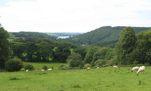
This is a landscape of contrasts, with ridges of higher land separated by the winding wooded valley of the River Tavy. Extensive dark mixed plantation covers its valley sides, creating a sense of isolation and secrecy. Watermeadows on the valley floors and pockets of broadleaved woodland add variations in colour and texture. Streams glide between craggy wooded banks covered in mosses and ferns, tumble over boulders and rocks, and flow under ancient bridges. Sunken lanes twist their way up the valley sides towards an open landscape of pastoral fields, with sudden long views across to Dartmoor or the River Tamar. Buckland Abbey is nestled into the valley side, surrounded by parkland. The rich and diverse landscape has a strong sense of history, with prehistoric hillforts, farms, estates, villages and industrial remains all contributing to its sense of time-depth.
- Context
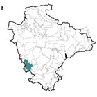
 This area is separated from the Tamar valley to the west by a narrow plateau which runs from Bere Alston to Lamerton. Its boundaries with adjacent landscape character areas are all fairly gradual. To the north are the Tamar Upland Fringe and Tavistock Dartmoor Fringes; to the east Central Dartmoor and Southern Dartmoor and Fringes; to the south Plymouth Farmland and the city of Plymouth and to the west the Lower Tamar and Tavy Valleys and the Middle Tamar Valley.
 - Constituent Landscape Character Types
Constituent LCTs: 1G: Open Inland Plateau, 1L: Upland Moorland with Tors, 2D: Moorland Edge Slopes, 3B: Lower Rolling Farmland and Settled Valley Slopes, 3D: Upland River Valleys, 3F: Settled Valley Floors, 3G: River Valley Slopes and Combes, 5A: Inland Elevated Undulating Land Part of NCA: 150: Dartmoor, 151: South Devon - Distinctive Characteristics
- Underlain by Devonian mudstone and sandstone geology, creating a much gentler topography than the adjacent basalt of Dartmoor, with less exposed rock.
- Rolling higher land in the east and west, divided by the steep-sided valley of the River Tavy.
- Steep, narrow streams flowing across areas of high land contrasting with the wider, meandering channel of the River Tavy.
- Extensive areas of dense mixed woodland lining the steep sides of the Tavy valley and its tributaries; elsewhere, woodland limited to roadside copses and individual oaks, with some riparian trees.
- Improved pasture over much of the area, with pockets of estate parkland, watermeadows and orchards, together creating a lush, green landscape.
- Stone-faced hedgebanks dividing medium-sized semi-regular fields, with survival of post-medieval ‘Barton’ fields resulting from estate tenure; much of the area has a strongly historic character.
- Extensive areas of unenclosed heathland, scrub, bracken and woodland in the eastern part of the area at Roborough Down and West Down.
- Historic features such as buildings, bridges and estate parkland creating a sense of time-depth and supporting notable populations of bats.
- Long history of mining from medieval times apparent within the landscape.
- Settlement generally consisting of dispersed farms, with occasional nucleated villages; 20th century expansion of Tavistock, and larger villages such as Buckland Monachorum and Crapstone.
- Straighter roads on higher land, but twisting, sunken lanes with hedgebanks on valley sides.
- Open views from higher land over the Tamar and Tavy valleys, and towards Dartmoor, contrasting with the sense of enclosure and tranquillity felt within the valleys.
Evaluation
- Special Qualities and Features
- Spectacular views eastwards towards Dartmoor from higher land as well as beautiful river views from the western and southern parts of the area.
- Outstanding scenic quality, reflected in designation of parts of the area as National Park or AONB; much of the area also providing an important visual setting to these two designations.
- Wealth of nature conservation interest, including extensive valley-side ancient woodland SSSIs e.g. Grenofen Wood and West Down; Lockridge Mine SSSI; woodland and unimproved grassland CWSs; and LNRs including former railway viaduct into Tavistock and Lopwell Dam on the River Tavy to south.
- Distinctive existing and former traditional orchards throughout the area, making a strong contribution to sense of place.
- RIGS site covering a fluvial geological exposure north of Buckland Monachorum.
- Extensive historic estates, including Buckland Abbey, owned by the National Trust and also a SM; other SMs reflect the area’s prehistoric importance, e.g. Marristow Camp and Berra Tor, the latter on the summit of a promontory over looking the Tavy Valley.
- Area part of Devon and Cornwall Mining Landscape WHS, reflecting long history of mining tin, lead, silver lead, copper and arsenic.
- Fascinating industrial archaeology associated with former quarrying, mining and transport, including the dismantled tramway on Roborough Down, the railway line between Bere Alston and Tavistock, and the canal and canal tunnel between Tavistock and Morwellham and several mills and associated features.
- The Lumburn Leat, a significant historic landscape feature constructed five hundred years ago, associated with medieval royal silver mines at Bere Ferrers (16 km in length with some sections still visible).
- Conservation Areas covering the historic cores of Milton and Buckland Monachorum.
- A popular area for tourists, including the ‘honeypot’ site of Buckland Abbey; numerous opportunities for visitors to stop and explore the area or enjoy the view.
- Tamar Valley Discovery Trail, West Devon Way and Cycle Route 27 provide important access opportunities as does open access land at West Down and Roborough Down.
Forces for Change and Their Landscape Implications
- Past and Current
- Replanting of valley-side woodlands with coniferous plantation, changing the character and appearance of the landscape.
- Loss of orchards and horticulture, reducing landscape distinctiveness and habitat diversity.
- Expansion of Tavistock southwards, resulting in urban influences on valley floor; some urban developments at Crapstone on the edge of the moor.
- Recreational use at Roborough Down resulting in an extensive network of eroded tracks and damage to semi-natural habitats.
- Recreational land uses such as Yelverton Golf Club changing the appearance, colour and texture of the landscape, the numerous car parks also being visually prominent.
- Invasion of scrub and bracken into areas of upland common and former valley pastures as a result of poor grazing management, with consequent loss of semi-natural habitats.
- Invasive water-borne weeds such as Himalayan balsam and knotweed, resulting in a loss of species diversity along river banks.
- Light pollution from Plymouth reducing the quality of the area’s night skies.
- Infestation with Phytophthora affecting larch plantations.
- Future
- Increased demand for recreation and holiday provision (particularly from nearby urban centres such as Plymouth) resulting in increased traffic and pressure on semi-natural areas e.g. Roborough Down.
- Continued demand for expansion of villages and adjacent urban areas (including Plymouth and Tavistock) potentially impacting on the rural and historic character of the area.
- Uncertainty over future levels of agricultural funding potentially affecting farm viability and the management of traditional agricultural features such as hedgebanks.
- Climate change affecting the species composition of woodlands and other habitats, as a result of changing growing conditions and the introduction of new pests and diseases; increased frequency of storm events may also damage trees and lead to woodland loss.
- Potential demand for renewable energy schemes such as hydro-electric power generation and wind turbines affecting the character of the landscape; domestic-scale renewables could also have a cumulative impact on the built fabric of the area.
Strategy
- Overall Strategy
To protect the landscape’s scenic quality, rural character and strong sense of place, and maintain and enhance its role in relation to Dartmoor National Park and the Tamar Valley AONB. The area continues to provide much-needed recreational provision for tourists and the residents of Plymouth, but in a sensitive way with minimal impact on the landscape and biodiversity. The area’s dramatic views and historic features are protected, understood and enhanced, with interpretation and public access where appropriate. Any development is carefully designed and sited to minimise its impact on the area’s rural character. Sustainable agriculture and the maintenance of traditional landscape features are supported. Semi-natural habitats such as heathland, woodland and watermeadows are well-managed to maximise their biodiversity and resilience to climate change.
Guidelines
- Protect
- Protect the area’s long views across Dartmoor and the Tavy and Tamar Valleys.
- Protect the area’s scenic quality, and enhance its role as a setting for adjacent protected landscapes.
- Protect the area’s high levels of tranquillity, resisting development which would reduce them.
- Protect locally-distinctive built features, such as stone-faced hedgebanks and stone bridges.
- Protect the dispersed settlement pattern, and traditional village form.
- Protect historic and archaeological features, including those associated with mining, with appropriate interpretation and management if necessary, and survey to assess current condition and management needs where required; implement the World Heritage Site Management Plan.
- Protect surviving field patterns and the landscape’s network of quiet lanes enclosed by woodland and species-rich hedgebanks, resisting unsympathetic highways improvements or signage.
- Manage
- Manage farmland to retain its condition and well-managed appearance.
- Manage upland common land, heathland and alluvial pastures to enhance their appearance and biodiversity, including appropriate levels of livestock grazing.
- Manage woodland (including through traditional techniques such as coppicing) to maximise age diversity and to develop species composition appropriate to the area; encourage the reversion of coniferous plantation to deciduous woodland on maturity, especially on ancient woodland sites.
- Manage parkland, orchards, watermeadows and riparian trees to retain their biodiversity and presence in the landscape.
- Manage recreational pressure at popular sites by promoting alternative locations and sustainable transport options.
- Manage roadside verges and banks to maximise their biodiversity potential.
- Manage and eradicate if possible invasive water-borne weeds through appropriate methods of control though partnership working at a landscape scale.
- Plan
- Plan for the long-term restructuring of large conifer plantations in the Tavy valley, through gradual restocking with a range of native broadleaved species; consider retaining and promoting less prominent conifer plantations as recreational spaces (e.g. for mountain biking).
- Plan to create, extend and link semi-natural habitats such as heathland, hedges and woodlands, including through the reinstatement of lost field boundaries around Roborough.
- Plan to increase the numbers of traditional orchards, possibly through community-based local food projects; new orchards should fit with historic landscape character and re-use former orchard earthworks if possible.
- Plan to ensure that any appropriate new development in villages that is small in scale, respects traditional village form, and is well integrated into the landscape.
- Plan to ensure that any extension to Tavistock is sympathetic and does not damage the character of the landscape or the visual quality of the AONB.
- Plan to limit further urban development on the moorland fringe at Crapstone
- Plan to reduce light pollution from Plymouth.
- Plan green infrastructure networks connecting adjacent larger urban centres (Plymouth and Tavistock) with this area, enabling improved access into the countryside and providing a framework for potential future sustainable development.