This is a constantly-changing landscape which appeals to many senses through the endless patterns of light and water, the sounds of water and birds, and the smells of salt water and mud. The diversity of the estuary margins, and their contrast with the flat, tranquil waters at the heart of the estuary, give this landscape a strong visual appeal. Fringing woodlands and reed beds; silty promontories; mudflats and salt marshes; patches of bright yellow gorse on rocky outcrops; the ribbon of hedgerows above the water, and the stone quays with clusters of colourful houses together create a rich and colourful edge that contrasts with the simple landscapes of the surrounding hills and the open water.
- Context
This is a small area comprising the lower reaches of the Tamar and Tavy rivers within the Tamar estuary. The area encloses the river channels, inter-tidal zone, salt marshes and river margins. Upstream to the north and north-east respectively are the Middle Tamar Valley and River Tavy Middle Valley. The transition to the Middle Tamar Valley is gradual, while the start of the River Tavy Middle Valley is marked by the change in river character at Lopwell Dam. To the south is the City of Plymouth, and to the west the county boundary with Cornwall with a corresponding landscape character area on the Cornwall shore.
- Constituent Landscape Character Types
Constituent LCTs:4B: Unsettled Marine Levels
Part of NCA:151: South Devon - Distinctive Characteristics
- Low-lying topography (at or close to sea level) with low, rounded hills behind.
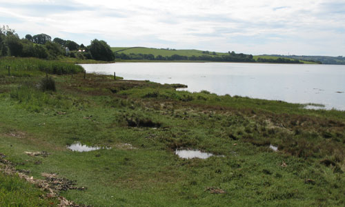
- The widest, tidal stretches of the Tamar and Tavy rivers.
- Small blocks of valley-side oak and birch woodland on the southern side of the Tavy, with an important line of hedgerow trees (often fruit trees, which may be a legacy of the area’s former soft fruit industry) separating the intertidal zone from the farmland above.
- A rich diversity of semi-natural habitats along the estuary margins, including reed beds, mudflats, salt marshes and rocky shorelines.
- Post-medieval reclaimed land at Warleigh Marsh indicated by straight boundaries; further embankments at Pennards Point and Blaxton Wood still present as landscape features.
- Historic stone quays, lime kilns, railway viaducts and waterside churches at Bere Barton providing strong visual links with the industrial past, and reflecting the valley’s historic importance as a transport route.
- Historic country houses with extensive grounds (Maristow House and Warleigh House) on the south bank of the River Tavy.
- Sparse settlement, consisting of occasional clusters of pastel-painted houses around quaysides.
- Very little modern development, largely due to the difficulty of accessing the area by road.
- Long, spectacular views giving a sense of space and openness.
- A largely inaccessible landscape which feels very remote.
- Patterns of light and water and sounds and smells that appeal to different senses, creating a strong sense of place.
Evaluation
- Special Qualities and Features:
- Outstanding estuarine views, including juxtaposition of estuarine and built elements including impressive structures such as the Tamar Suspension Bridge and Brunel’s Royal Albert Bridge (1859).
- High scenic value, within the Tamar Valley AONB.
- Tamar Estuaries Complex SPA, Plymouth Sound and Estuaries SAC and Tamar-Tavy Estuary SSSI provide internationally important bird habitat, support rare estuarine species and include valley side oak woodlands at Warleigh Wood and Blaxton Wood, contributing to landscape enjoyment.
- RIGS site covering geological exposure on the east bank of the Tamar.
- LNR at Warleigh Wood, providing an opportunity for public access into the natural environment.
- Listed buildings and structures including Warleigh House, Maristow House, Bere Barton Church and Tavy Rail Bridge.
- Tamar Valley Discovery Trail long-distance route following stretches of the water’s edge.
- The Tamar Valley railway line offering outstanding elevated views of the area from its viaducts across the estuary.
Forces for Change and Their Landscape Implications:
- Past and Current
- Little management of intertidal zone, potentially affecting its landscape and biodiversity interest.
- Visually-intrusive power lines across the area.
- Dereliction of abandoned quays and lime kilns.
- Light pollution from Plymouth.
- Increase in water-based recreation, pressure on moorings and frequent planning issues around new launch sites.
- Future
- Potential visually intrusive and ecologically-damaging developments such as waterside marinas and launch points.
- Changes in sea level as a result of climate change affecting channel depths and semi-natural habitats along its margins.
- Changes in water temperature and/or salinity as a result of climate change affecting the diversity of habitats and species present.
Strategy
- Overall Strategy:
Maintain the unique estuarine character of this area, protecting its scenic quality, rich biodiversity, and its strong sense of place. The range of semi-natural habits (mudflats, reed beds, salt marshes etc) along the estuary margins is retained and managed to maximise their landscape and biodiversity interest. The area’s undeveloped, remote feel is retained and historic buildings, settlements and structures remain attractive focal points in the open, water-dominated landscape.
Guidelines:
- Protect
- Protect the important views to the water’s edge and historic built structures that characterise this landscape.
- Protect the range of internationally-designated habitats present within the area.
- Protect historic quays and other buildings and structures which contribute to the area’s strong sense of place.
- Protect the unsettled character of the landscape.
- Protect the water’s edge from damage through the restriction of high-speed vessels if necessary.
- Manage
- Manage estuarine habitats (salt marshes, reed beds mudflats etc) to maximise their landscape and biodiversity value.
- Protect and manage the locally-distinctive fruit trees in the hedgerows that separate the estuary from the farmland behind.
- Manage the valley-side oak and birch woodlands.
- Plan
- Plan to conserve the distinctive water’s edge character and resist plans for waterside developments (including marinas) in the area.
- Plan to create new intertidal habitat where possible.
- Plan to investigate the undergrounding of visually-intrusive power lines.
- Plan to reduce levels of light pollution from Plymouth.