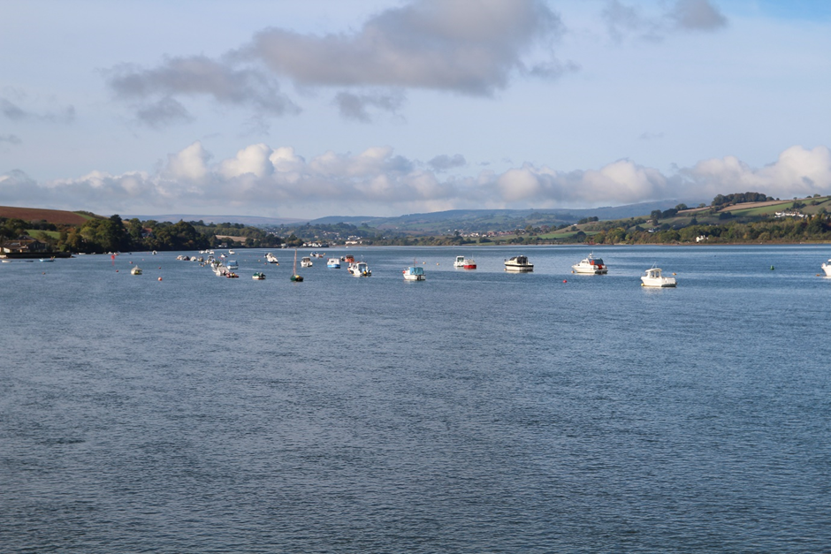
The Teign Estuary includes the broad tidal river channel, intertidal areas and adjacent lower slopes. The estuary is defined by steeply rising high rounded hills with distinctive folds to the north and south. The river channel and the intertidal mudflats with their dynamic pattern of winding creeks dominate the landscape, and along with the enclosing hills and expansive cross-estuary views, provide a very strong sense of place. At high tide the estuary becomes a large expanse of water and the changing tides and presence of seabirds and waders add diversity and movement. To the south, there is a succession of sheltered inlets with shingle beaches at the mouths of combes; and intervening sandstone cliffs; while to the north gently rising slopes with an undulating shoreline give way to steeper hills around Bishopsteignton and Teignmouth. On these valley sides land use is predominantly pastoral with strong hedgerow patterns. This is often a busy landscape with movement along transport corridors and recreational activity on the estuary although greater tranquillity can be found within secluded combes and along parts of the estuary shore. This landscape has notable views to adjacent landscapes and other landscapes further afield, including Dartmoor; while at the mouth of the estuary Shaldon and Teignmouth frame views out to sea.
- Constituent Landscape Character Types
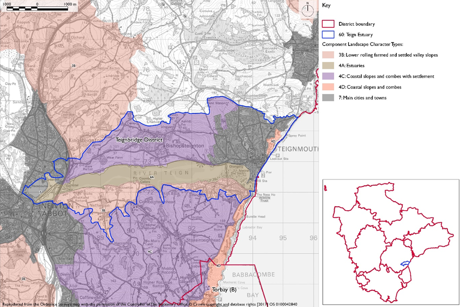
4A: Estuaries
3B: Lower Rolling Farmed and Settled Valley Slopes
4C: Coastal Slopes and Combes with SettlementPart of National Character Area: 148: Devon Redlands
- Contextual Description
This character area has an east-west alignment comprising the tidal section of the River Teign and adjacent farmland between Newton Abbot in the west and Teignmouth in the east. It is flanked to the north by the rising land which forms the lower slopes of the Haldon Ridge, and to the south by the Breccia Hills and Coast.
Summary Description
The Teign Estuary includes the broad tidal river channel, intertidal areas and adjacent lower slopes. The estuary is defined by steeply rising high rounded hills with distinctive folds to the north and south. The river channel and the intertidal mudflats with their dynamic pattern of winding creeks dominate the landscape, and along with the enclosing hills and expansive cross-estuary views, provide a very strong sense of place. At high tide the estuary becomes a large expanse of water and the changing tides and presence of seabirds and waders add diversity and movement. To the south, there is a succession of sheltered inlets with shingle beaches at the mouths of combes; and intervening sandstone cliffs; while to the north gently rising slopes with an undulating shoreline give way to steeper hills around Bishopsteignton and Teignmouth. On these valley sides land use is predominantly pastoral with strong hedgerow patterns. This is often a busy landscape with movement along transport corridors and recreational activity on the estuary although greater tranquillity can be found within secluded combes and along parts of the estuary shore. This landscape has notable views to adjacent landscapes and other landscapes further afield, including Dartmoor; while at the mouth of the estuary Shaldon and Teignmouth frame views out to sea.
- Distinctive Characteristics
- Open, flat, low-lying estuary landscape with adjacent lower slopes, enclosed by steeply rising high rounded hills, with sheltered inlets, shingle beaches and sandstone cliffs along the south side.
- Underlying red soils occasionally visible in ploughed fields, cliffs and hedgebanks.
- A patchwork of mainly pastoral fields (with some notable areas of arable) on the estuary slopes, delineated by a network of mature hedgerows, with occasional small woodlands which create a distinctive pattern.
- Semi-natural habitats include the river channel, intertidal habitats of mudflats, shingle banks, sand spits and marshes, broadleaved woodland and mature hedgerows.
- Historic features include vernacular buildings, historic coastal railway, flood walls, and quays.
- Settlement pattern of large villages (Bishopsteignton, Shaldon, Ringmore), scattered farms, houses and hamlets frequently containing vernacular buildings of cob and thatch, render and slate, particularly in the smaller settlements.
- Main roads with bridge crossings near mouth (A379/A381) and head of estuary (A380) and mainline railway following the north shore.
- Occasional leisure and industrial developments along the estuary slopes and frequent small boats, boatyards, moorings, quays and slipways, particularly at Shaldon, Ringmore and Teignmouth.
- Expansive views across open water and intertidal mudflats from estuary edge and adjacent slopes and some channelled views out to sea, framed by the settlements of Teignmouth and Shaldon and connecting bridge at the estuary mouth.
Evaluation
- Special Qualities and Features
- High scenic quality associated with expanses of open water, mudflats, changing tides and birdlife, complemented by the adjacent pasture fields and visually pleasing pattern of hedgerows and small vernacular settlements.
- Generally strong sense of openness, with many stunning views – sunsets with Dartmoor in profile and sunrises over Shaldon are notable.
- Secluded combes along the estuary shore which have a secretive and intimate character.
- RIGSs along the edge of the estuary shore (Teignmouth Road cutting, Luxton’s Steps, Netherton, and Combe Cellars).
- Distinctive coastal features including The Ness red sandstone cliff headland on the south side of the estuary mouth.
- Estuary and parts of the valley sides designated CWSs for their open water, coastal saltmarsh and mudflats, and mixed farming systems which provide valuable habitat for birds including cirl bunting.
- Strong maritime character and distinctiveness due to frequent small boats and moorings, shoreline railway and coastal settlements.
Forces for Change and Their Landscape Implications
- Past and Current
- Loss of tranquillity due to disturbance by noise and movement from main roads, bridge crossings and development.
- Scenic quality eroded locally by industrial and leisure developments and some unsympathetic development on the edges of Bishopsteignton, Teignmouth, Newton Abbot and Kingsteignton resulting in visual intrusion and night light pollution.
- Sea level rise and coastal erosion due to climate change, potentially resulting in a rise in the estuary’s water levels, widening of the channel, loss of existing mudflats and intertidal habitats and increase in flood defences.
- Construction of new, large-scale agricultural buildings, which would be out of context with existing traditional, smaller-scale buildings.
- Need for farms to have slurry tanks in response to new waste management regs – increasing industrialisation of farmsteads.
- Current pressure for increased landfill capacity to accommodate inert waste from development sites on steep or undulating topography
- Future
- Continuing sea level rise and coastal erosion due to climate change, potentially resulting in a rise in the estuary’s water levels, widening of the channel, loss of existing mudflats and intertidal habitats and increase in flood defences.
- Potential for new leisure and recreation development and visitor pressure, eroding rural character and potentially damaging or disturbing sensitive habitats.
- New development at the fringes of the urban areas and larger villages and on undeveloped estuary sides, potentially affecting estuary views and eroding rural character.
- Potential agricultural intensification, leading to a loss of traditional field boundaries and a change to existing landscape pattern and industrial-style slurry tanks that are potentially not in scale and character of traditional farmsteads.
- Conversion of traditional agricultural buildings and attached land for domestic and leisure use, which can lead to unsympathetic boundary and surfacing treatments and erosion of rural character.
- Widening and new access points to narrow lanes, eroding their rural character.
- Demand for renewable energy schemes, including wind turbines and solar arrays, particularly on south-facing estuary slopes.
- The change /transition to the new land management system (ELMS) promises to be positive for the environment- more so than the CAP- and offers opportunity to strengthen landscape features and characteristics.
- Need for landfill/landraising within construction sites and modification of natural topography.
- Need for attenuation basins as part of SuDS as a requirement of new development.
Strategy
- Overall Strategy
To protect and conserve the scenic quality and nature conservation value of this landscape. Opportunities to conserve and enhance estuary views and intertidal habitats, hedgerows, woodland and historic features are sought. New development respects the character and quality of estuary views. The pattern of fields, hedgerows and narrow lanes continues to reflect the area’s historic and vernacular character.
Guidelines
- Protect
- Protect the open character of the estuary and the important expansive cross-estuary and sea views.
- Protect the scattered rural settlement pattern of houses, farmsteads and hamlets and ensure that new development reflects the vernacular character.
- Protect and enhance the landscape setting of Teignmouth, Shaldon, Ringmore and Bishopsteignton, ensuring new development enhances features such as hedgerows and woodlands.
- Protect, and where appropriate, restore historic features along the estuary edges, including quays and bridges. Provide sensitive interpretation to help tell the story of the landscape and its cultural significance.
- Protect the undeveloped character of remaining areas of designated undeveloped coastline.
- Manage
- Manage mature hedgerow network, particularly ancient boundaries, and encourage traditional hedgerow management practices.
- Manage broadleaved woodland particularly along the water’s edge and on ridgelines.
- Manage the estuary’s important habitats including saltmarshes and mudflats, ensuring marshes are grazed at appropriate levels.
- Manage agricultural land fringing the estuary, encouraging local farmers to use their land to enhance birdlife habitat.
- Manage areas of semi-natural habitat. Link and extend habitats where possible to increase biodiversity, contribute to nature recovery networks and provide suitable habitats for flora and fauna.
- Plan
- Plan for the sensitive location of new development, avoiding prominent valley sides, unfettered ridge lines and shoreline locations, and ensuring that settlements retain their individual identity.
- Plan for the future impacts of climate change, particularly as a result of sea level rise and coastal erosion, allowing natural processes to take place wherever possible.
- Plan for opportunities to expand estuarine habitats to build resilience to future climate change.
- Plan a landscape-led response to the UK-wide policy drive for increased tree and woodland planting, implementing Devon Local Nature Partnership’s ‘Right Place, Right Tree’ principles to create a balance of climate-resilient native species appropriate to the local landscape.
- Plan to contribute to nature recovery networks and provide suitable habitats for flora and fauna.
- Plan to ensure a cut and fill balance from new development to ensure no export of waste soils to landfill. Where new or extended landfill is needed, ensure the landform restoration design respects the character of the distinctive natural topography, avoid artificial engineered landforms, and integrate into the landscape.
- Plan for new slurry tanks to be grouped with other farm buildings, recess into ground, use natural topography and trees for screening and integration and sensitive colour treatment with dark recessive colour to minimise visual impact.
- Plan for attenuation basins as part of SuDS required as part of development designing for biodiversity and amenity enhancement, where possible to enhance development not just provide engineering function.