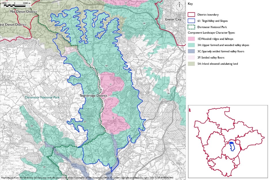
- Constituent Landscape Character Types
Constituent Landscape Character Types:
2A: Steep Wooded Scarp Slopes
3A: Upper Farmed and Wooded Valley Slopes
2B: Lower Rolling Farmland and Settled Valley Slopes
3G: River Valley Slopes and Combes
1H: Forested PlateauPart of National Character Area:
148: Devon Redlands
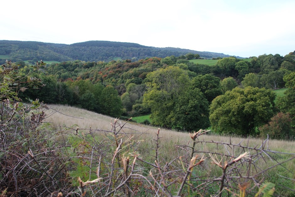
View west from lane west side of Warboro Plantation towards land rising to the Haldon Ridge.
GPS Coordinates: 295858, 82145
- Contextual Description
This area comprises a distinctive sandstone ridge running north-south from the A30 to the Teign Estuary and its surrounding farmland. To the north, the ridgeline gives way to a rolling upland landscape; in the west the spurs and valleys of the valley slopes interlock with the River Teign; and to the east, a patchwork of minor ridges and valleys flows eastwards towards the Exe estuary and coast. To the south the area is more open and broadens into farmland comprising a series of ridges and valleys extending to the coast at Dawlish.
Summary Description
The Haldon Ridge and Foothills has a strong sense of place and is one of the most prominent landscape features in eastern Devon, affording a textured, rising backdrop to much of the surrounding landscape, including the towns of Teignmouth and Dawlish and parts of Exeter. The area encompasses a narrow, forested plateau with adjoining steep scarp slopes broadening to more open farmed ridges and valleys to the south. From this landscape there are spectacular panoramic views east to the coast and west to Dartmoor. In places, the sides of the main wooded ridge are deeply incised with combes and small river valleys lending topographic interest. This landscape supports a diverse range of habitats including heathland, conifer plantations, mixed and broadleaved woodland, with a higher concentration of pasture and arable fields to the south. Collectively these land uses give rise to high scenic quality and provide varied texture and seasonal changes. This landscape also includes notable areas of parkland.
- Distinctive Characteristics
- Central core underlain by Upper Greensand and flint gravel ridge; thin stony sand or sandy brown soils blending into red sandstone soils in the foothills; limestone outcrop near Chudleigh, with natural caves and past quarrying.
- Imposing, flat-topped, tree-clad ridge and surrounding foothills.
- Dominant backdrop to the Exe estuary and Exeter to the east, the valley of the River Teign and Dartmoor to the west; and the Teign estuary to the south.
- Deeply incised combes cut into the west side of the ridge; while to the south the foothills are drained by incised streams including Dawlish Water, Colley Brook and Kate Brook.
- Extensive coniferous forests particularly on the ridge; mixed and broadleaved woodland on steep slopes and valley sides.
- In the foothills, a rich patchwork of irregular pasture and arable fields of small to medium size bounded by mature hedgerows with trees.
- Remnant heathland and ancient semi-natural broadleaved woodland particularly on valleys sides and steep scarp slopes.
- The large areas of open lowland heathland, including Great Haldon Heaths SSSI and Little Haldon Heaths SSSs, provide a rich habitat for wildlife and a distinctive landscape. Haldon Forest SSSI attracts a range of rare birds and butterflies to its rides and recently felled conifer stands. Broadleaved woodland and scrub add to the range of habitats here and, in the south of the area, support the rare species Devon Whitebeam, whose clusters of white flowers add a distinctive note along roadsides in May. Prehistoric remains including cairns, barrows and hillforts (e.g. Castle Dyke Fort) reflecting earlier, unenclosed landscape.
- Mamhead Park and Oxton Estate, historic parkland landscapes and historic estates containing veteran and mature trees.
- Very sparse settlement on the ridge where there are occasional isolated vernacular stone farmsteads and buildings associated with trunk roads, forestry or leisure activities.
- Dispersed settlement in the foothills, with some larger settlements e.g. Chudleigh and Holcombe and small common edge villages e.g. Ideford and Luton; vernacular buildings of thatch and cob or stone and slate.
- Dualled trunk roads crossing the landscape, introducing noise and movement; elsewhere a network of sunken, narrow winding lanes, often with tree lined banks.
- Leisure and recreation within Forestry Commission conifer plantations; larger leisure developments at Exeter racecourse and Teignmouth golf course.
- Strong sense of tranquillity and remoteness, with dark night skies.
- Spectacular panoramic views from the ridge across adjacent landscapes, east to the coast and west to Dartmoor contrasting with a strong sense of enclosure within the woodlands.
- Coastal cliffs, rocks and stacks along coast at Dawlish and notable steep red sandstone cliffs with railway hugging the coast.
Evaluation
- Special Qualities and Features:
- High scenic quality and strong sense of place due to distinctive landform and contrast between enclosed woodland and open heath; patchwork of woodland and heathland also gives a varied texture and seasonal contrast.
- Wooded ridge punctuated by Haldon Belvedere on the skyline visible from, and forms an important backdrop to, the Exe and Teign Estuaries and Dartmoor. Also contributes to Exeter’s rural landscape setting, visible in many views from the City.
- Magnificent panoramic views of the coastal and inland landscapes.
- Many natural heritage features, including heathland (much designated as SSSI particularly around Little Haldon), mixed and broadleaved woodlands (many ancient – Eastern Cotley Woods, Tower Wood, Luscombe Woods and Holcombe Wood), scrub and rough grassland.
- Prehistoric remains including cairns, barrows and hillforts reflecting the earlier open landscape, much of which was enclosed from heathland in the late 19th century.
- Important parkland landscapes including Luscombe Castle, Stonelands House, Lindridge, Mamhead and Ugbrook Park and House; some scarp woodlands also form parts of former estate designed landscapes and include historic features such as the distinctive landmark of Haldon Belvedere (Lawrence Castle).
- Strong sense of tranquillity overall, in places disturbed by recreational activities within the forests and by traffic and leisure developments along the busy main roads.
Forces for Change and Their Landscape Implications
- Past and Current
- Occasional masts, pylons, unsympathetic leisure (racecourse and golf course) and road developments that erode scenic quality in places.
- Road improvements and associated development (e.g. filling stations) on the A38, A380 and A379, affecting the tranquillity of the immediate area.
- Two parallel lines of pylons that cross the southern half of this character area and affect scenic quality.
- Agricultural intensification and hedgerow removal, particularly in the east and south creating a more open landscape and loss of historic pattern.
- Past quarrying of limestone around Chudleigh.
- Urban expansion of some settlements such as Chudleigh, Dawlish and Holcombe, altering historic character and pattern.
- Loss of heathland through extensive conifer planting.
- Major engineering works are being undertaken on the Exeter to Teignmouth Riviera Railway Line resulting from the major damage caused by storms in 2019. Increasing severity of storms threatening coastal rail infrastructure, stability of cliffs and natural coastal defences resulting in requirement for major coastal engineering works.
- Pressure for new solar farms and masts.
- Need for farms to have slurry tanks in response to new waste management regs – increasing industrialisation of farmsteads.
- Future
- Road improvements and roadside developments along the dualled trunk roads, which could lead to the erosion of remote and undeveloped character.
- Pressure for new masts, wind turbines and solar farms, which could have a very high visual impact on this elevated landscape and its distinctive skyline.
- New leisure development, which could be highly visually intrusive in elevated locations.
- Recreational pressures within forestry and woodland, which may disturb sense of tranquillity and introduce signage clutter or erode sensitive ground flora or heathland habitats.
- Changes in woodland management, leading to changes in species composition and in the amount and distribution of woodland and heathland.
- Loss or damage to heathland, due to lack of management or erosion from recreational use.
- Continued sand quarrying and some landfill activity.
- Pressure for residential development on the edge of Chudleigh and Dawlish which could be highly visible along the ridge and require further infrastructure.
- Potential agricultural intensification, leading to loss of traditional field boundaries and patterns.
- Construction of new, large-scale agricultural buildings, which would be out of context with existing traditional, smaller-scale buildings and industrial-style slurry tanks that are potentially not in scale and character of traditional farmsteads.
- Conversion of traditional agricultural buildings and land for domestic and leisure use, potentially bringing unsympathetic boundary and surfacing treatments and erosion of rural character.
- Widening and new access points to narrow lanes, eroding their rural character.
- Higher sea level and storm frequency as a result of climate change, leading to increased coastal erosion and cliff instability.
- Plan for appropriate landscape and environmental enhancement measures to be incorporated into any major engineering works on the Exeter to Teignmouth Riviera Railway Line.
- The change /transition to the new land management system (ELMS) promises to be positive for the environment- more so than the CAP- and offers opportunity to strengthen landscape features and characteristics.
- Need for landfill/landraising within construction sites and modification of natural topography.
- Need for attenuation basins as part of SuDS as a requirement of new development.
Strategy
- Overall Strategy
To protect the panoramic views to and from the wooded ridge as well as to key features and landmarks such as Haldon Belvedere; manage the network of valued semi-natural habitats including broadleaved woodland and heathland and varied historic features. Opportunities are sought to restore broadleaved woodland particularly along valley sides and steep slopes and to restore and connect areas of heathland. The landscape’s time-depth continues to have a strong influence, whilst opportunities for sustainable recreation and limited low-carbon development are sensitively accommodated. Field patterns are reinforced through the restoration and management of Devon hedgebanks using traditional management techniques. New development is sympathetic to the existing field pattern, woodland and lanes and reflects existing patterns and local vernacular.
Guidelines
- Protect
- Protect dramatic panoramic views to and from the ridge by sensitive siting of development, particularly tall structures, and the avoidance development on prominent ridges and valley sides.
- Protect the overall strong sense of tranquillity and dark night skies.
- Protect views to historic landmarks, such as Haldon Belvedere (Lawrence Castle).
- Protect and appropriately manage the rich cultural heritage of the area including Bronze Age barrows, hillforts and historic parklands through appropriate management agreements and conservation management plans.
- Protect the historic settlement pattern of occasional farmsteads and small villages and prevent settlement expansion which is uncharacteristic or undermines perceptions of traditional form and character or the rural character of historic lanes.
- Protect traditional building styles and materials, particularly thatch and cob or stone, utilising the same styles and materials in new development wherever possible (whilst seeking to incorporate sustainable design).
- Protect the undeveloped character of remaining areas of designated undeveloped coast.
- Manage
- Manage existing field enclosures and enhance the network of hedgerows and hedgebanks through reinstatement of enclosure where it has been previously lost.
- Manage the network of broadleaved woodland, banks and lines of mature trees; and remove laurel and rhododendron where they have colonised.
- Manage the mosaic of heathland habitats for landscape and wildlife benefits.
- Manage the areas of historic parkland and associated features including veteran trees through the development of conservation management plans.
- Manage the South West Coast Path to maintain the rural character of the landscape and reduce soil erosion through the sensitive design of surfacing, way marking and signage.
- Manage coastal habitats to conserve and enhance; and encourage interpretation of geological and ecological features.
- Manage areas of semi-natural habitat. Link and extend habitats where possible to increase biodiversity, contribute to nature recovery networks and provide suitable habitats for flora and fauna.
- Plan
- Plan to screen visually intrusive sections of the A38 and A380 corridors to limit the impact of noise and movement on the surrounding landscape.
- Plan for gradual heathland restoration through reduction in conifer plantations and replacement with a balanced mix of broadleaved woodland and heathland.
- Plan for the planting of deciduous edges to coniferous plantations to reduce impact of harsh edges and clear fells.
- Plan for the progressive restoration of quarries and associated landfill sites, including woodland, grassland and wetland enhancements.
- Plan for the enhancement of the landscape settings of Teignmouth, Dawlish and Newton Abbot within and adjacent to this landscape character area through appropriately sited woodland and hedgerow planting.
- Plan for the interpretation of features of ecological, geological and historic interest.
- Plan for the future impacts of climate change, particularly as a result of sea level rise and coastal erosion, allowing natural processes to take place wherever possible.
- Plan for the sensitive location and design of new development in the countryside, avoiding significant effects on the setting and special qualities of Dartmoor of Dartmoor National Park considering effects of built development and lighting on rural tranquillity and the quality of views.
- Plan a landscape-led response to the UK-wide policy drive for increased tree and woodland planting, implementing Devon Local Nature Partnership’s ‘Right Place, Right Tree’ principles to create a balance of climate-resilient native species appropriate to the local landscape.
- Plan to contribute to nature recovery networks and provide suitable habitats for flora and fauna.
- Plan for appropriate landscape and environmental enhancement measures to be incorporated into any major engineering works in particular on the Exeter to Teignmouth Riviera Railway Line.
- Plan for new slurry tanks to be grouped with other farm buildings, recess into ground, use natural topography and trees for screening and integration and sensitive colour treatment with dark recessive colour to minimise visual impact.
- Plan for landfill/landraising of development sites and modification of natural topography by designing new landform in character with topographic context, avoid artificial engineered landforms, and integrate into the landscape.
- Plan for attenuation basins as part of SuDS required as part of development designing for biodiversity and amenity enhancement, where possible to enhance development not just provide engineering function.