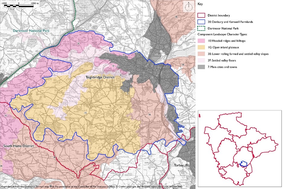
- Constituent Landscape Character Types
Constituent Landscape Character Types
1E: Wooded Ridges and Hilltops
1G: Open Inland Plateau
3B: Lower Rolling Farmed and Settled Valley Slopes
3F: Settled Valley Floor
Part of National Character Area
151: South Devon
- Contextual Description
 This area comprises elevated farmland with distinctive hills to the west and south of Newton Abbot and includes the river valleys of the Lemon River and Aller Brook to the north and east respectively. To the south the landscape is bounded by a gradual transition into the Dart Valley and to the west by the rising land of the East Dartmoor Moorland Fringes. East of Aller Brook the land rises sharply to form the Breccia Hills and Coast.
Summary Description
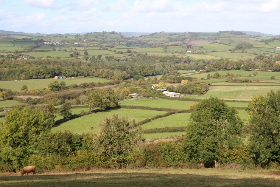
This landscape encompasses an undulating elevated area with notable hills which are prominent in views and distinctive in their form and in their patterns of woodland cover. These hills reflect the underling limestone geology which is also expressed in local vernacular buildings and in the woodland and semi-natural grassland flora, and visible in the form of quarries and rock outcrops. Coupled with more distant views to Dartmoor that provide the area with a strong sense of place. Between the hills there are small streams and springs; and to the north and east the River Lemon and Aller Brook create more substantial valleys. This is predominantly a historic rural landscape, both in terms of medieval field patterns, remnant commons, a dense network of winding lanes and nucleated settlements. However it also contains more modern elements which cut across the historic grain including railway lines, pylons, quarrying and landfill activity and housing development on the edge of settlements.
- Distinctive Characteristics
- The underlying geology is mainly limestone with areas of slates and shales to the west and sandstone to the east.
- Limestone geology reflected in distinctive hilltops (e.g. Denbury Down and Beacon Hill), quarries (e.g. Stoneycombe Quarry), natural caves and outcrops (e.g. near Torbryan) and use of limestone in walls and buildings.
- Undulating plateau with distinct, prominent hills rising above it, dissected by streams and the rivers Lemon and Aller Brook.
- Steep, narrow, well-wooded Lemon Valley and tributaries (Kester and Barham’s Brooks) draining the higher ground to the north.
- Broadleaved and mixed woodland, some ancient, often on distinctive hilltops or steep valley slopes, with species composition reflecting the limestone geology.
- Irregular patchwork of pasture and occasional arable fields delineated by a dense network of treed hedgebanks.
- Medieval field pattern of small scale enclosures with some larger fields on gentle slopes particularly in the north around the Lemon Valley.
- Mixed and broadleaved woodland (some ancient woodland), mature hedgebanks and trees, semi-improved/unimproved grassland and scrub on commons, natural caves and outcrops and springs.
- Cultural heritage features that include medieval field patterns, nucleated settlement, hillforts, occasional old orchards and small parks (e.g. West Ogwell) and commons (e.g. Kerswell Down Hill).
- Settlement pattern of scattered farms and hamlets and nucleated villages with frequent vernacular buildings of limestone, slate, cob and thatch and use of brick and render in modern developments.
- Dense network of winding, narrow lanes are disorientating and contrast with the linear routes of power lines and railways.
- Strong sense of tranquillity, disturbed locally close to A381, A380 and A383.
- Views dominated by prominent hills and distant mass of Dartmoor with more intimate enclosed landscapes in lower-lying areas and river valleys.
Evaluation
- Special Qualities and Features
- Distinctive hills whose form and field and woodland patterns create scenic compositions; these hills together with the Lemon gorge forming a valued rural setting to Newton Abbot and enclosing the area’s nucleated villages.
- Limestone geology that gives rise to distinctive vernacular buildings, old quarries and natural caves (e.g. Torbryan Caves) and rock outcrops.
- Disused limestone quarry supports distinctive species as they revegetate.
- Torbryan Caves SSSI supports roosting bats and has fossil interest.
- Many natural heritage sites designated as SSSI and CWS including mixed, broadleaved and ancient woodland (notably in the Lemon Valley), semi-improved and unimproved grassland and scrub (e.g. Whilborough Common) and geological features.
- Species-rich, agriculturally-unimproved limestone grassland with associated species-rich scrub. Large areas are present on plateaux at Orley Common.
- Many cultural heritage features including nationally important SMs (e.g. Berry’s Wood Earthwork, Denbury Camp, barrows near Dornafield Farm and the prehistoric field systems on Kerswell Down and Whilborough Common).Numerous Conservation Areas within nucleated settlements e.g. Denbury, East Ogwell, Abbotskerswell and Broadhempston), old orchards (e.g. Kester Valley), small parks (e.g. Bradley Manor), commons (e.g. Orley Common) and historic bridges and mills along the river valleys.
- Areas of open access land on Kerswell Down Hill and Whilborough Common offering valuable open space to local settlements.
- Some of the best preserved orchards in Devon.
- Strong sense of tranquillity in the south and west.
Forces for Change and Their Landscape Implications
- Past and Current
- Large power lines and mainline railway that cut across the historic grain of the landscape.
- Past urban expansion of Kingskerswell, Abbotskerswell, Ipplepen and Newton Abbot, with the use of uncharacteristic materials such as brick.
- Development of a prison complex occurs on the outskirts of Denbury.
- Tranquillity and scenic quality eroded locally by a mix of modern developments close to the A381, the A383, the A380 at Kingskerswell, Newton Abbot, and nearby large villages.
- Construction of A381 Kingerswell Bypass.
- Planting of conifer blocks in Barham’s Brook Valley and beech plantations in the Lemon valley; and weakening of hedgerow patterns on lower gentler slopes adjacent to river valleys where arable farming is more common.
- Leisure developments along the A383 and A381 and on the outskirts of Newton Abbot e.g. golf courses and garden centres.
- Construction of solar farms between Abbotskerswell and Denbury and pressure to build others.
- Legacy of past quarrying activity and landfill sites between Kingskerswell and Abbotskerswell.
- Loss of orchards through lack of management.
- Natural regeneration of former quarry sites.
- Landfill operations at Yannon Lane, Kingsteignton.
- Current pressure for increased landfill capacity to accommodate inert waste from development sites on steep or undulating topography.
- Need for farms to have slurry tanks in response to new waste management regs – increasing industrialisation of farmsteads.
- Future
- Pressure for urban extensions at the southern edge of Newton Abbot, around Ogwell Cross, towards Seale Hayne and around Kingskerswell.
- Further expansion of existing villages such as Kingskerswell, Abbotskerswell and Ipplepen, which could erode rural character.
- Potential for new leisure developments such as garden centres and caravan parks along the A381 and A383 corridors, again eroding rural character.
- Construction of large extensions to existing houses and other buildings, and new buildings in high visibility locations on hilltops and sides, resulting in visual intrusion and loss of vernacular character.
- Potential agricultural intensification, leading to loss of traditional field boundaries, archaeological features and old orchards and a change to existing landscape pattern.
- Construction of new, large-scale agricultural buildings, which can be out of scale with existing traditional, smaller-scale buildings and industrial-style slurry tanks that are potentially not in scale and character of traditional farmsteads.
- Conversion of traditional agricultural buildings and attached land for domestic and leisure use, which can lead to unsympathetic boundary and surfacing treatments and erosion of rural character.
- Widening and new access points to narrow lanes, eroding their rural character; potential road improvements to the A38, A383 and A381
- Pressure for new masts, wind turbines and pylons, potentially highly visible on prominent hillsides.
- Pressure for new solar farms which could have a very high visual impact on the visually prominent valley sides and hilltops of this elevated landscape.
- Expansion of existing quarries and landfill sites resulting in impact on surrounding landscape. Restoration of landfill operations at Yannon Lane, Kingsteignton.
- The change /transition to the new land management system (ELMS) promises to be positive for the environment- more so than the CAP- and offers opportunity to strengthen landscape features and characteristics.
- Need for landfill/landraising within construction sites and modification of natural topography.
Need for attenuation basins as part of SuDS as a requirement of new development.
Strategy
- Overall Strategy
To protect the landscape’s distinctive landform and historic patterns of land use, vegetation and settlement, strengthening its special qualities and features and conserving views to distinctive hilltops. Opportunities are sought to manage commons to increase diversity of semi-improved grasslands. Field patterns are reinforced through the restoration and management of hedgebanks. Hilltop and valley-side woodlands are managed to retain distinctive patterns of vegetation cover. The landscape’s time depth continues to have a strong influence, whilst opportunities for sustainable recreation, limited low-carbon development and limestone quarrying are sensitively accommodated. The historic character of the nucleated settlements is enhanced and new development reflects local vernacular and settlement form.
Guidelines
- Protect
- Protect extensive views to distinctive hilltops and longer views to Dartmoor.
- Protect the landscape setting of Newton Abbot and other settlements through appropriate management and new planting which integrate urban extensions with their surroundings.
- Protect the settlement pattern of scattered farms and hamlets and nucleated villages and ensure that new development reflects the vernacular character.
- Protect the network of historic lanes and ensure new development protects their rural character avoiding unnecessary widening, concrete kerbing or signage.
- Protect the patterns of field enclosure, particularly remnant medieval field enclosures and limestone hedgebanks.
- Protect historic river features such as bridges and mills as well as other historic features including hillforts, orchards and the pattern of narrow lanes.
- Protect areas of open space and open access land for recreational use to the west of Kingskerswell and avoid physical fragmentation or severance from local settlements due to bypass construction.
- Manage
- Manage the hedgerow network by encouraging traditional hedgerow management practices.
- Manage broadleaved woodland (particularly on prominent hilltops and valley sides) to retain distinctive patterns of vegetation cover, promote a diverse age and species structure, and increase resilience to climate change; restore conifer plantations to broadleaves where feasible.
- Manage archaeological sites and historic features such as SMs, old orchards, parkland, mills and bridges.
- Manage semi-improved and unimproved grasslands and scrub particularly on areas of remnant common.
- Restore and manage areas of relict traditional orchards to encourage biodiversity and local fruit varieties.
- Manage recreational pressure at popular sites by promoting sustainable transport options; any signage or infrastructure requirements should be kept to a minimum and be sensitively sited within the landscape setting.
- Seek opportunities for new recreation provision through green infrastructure linking settlements with surrounding landscape.
- Manage areas of semi-natural habitat. Link and extend habitats where possible to increase biodiversity, contribute to nature recovery networks and provide suitable habitats for flora and fauna.
- Plan
- Plan for the sensitive location of new development, avoiding prominent hilltops and slopes.
- Plan for the restoration of mineral extraction and landfill sites.
- Plan for the creation of traditional orchards, including community projects to promote local food and drink production.
- Plan to mitigate climate change impacts allowing natural process to take place where possible.
- Plan a landscape-led response to the UK-wide policy drive for increased tree and woodland planting, implementing Devon Local Nature Partnership’s ‘Right Place, Right Tree’ principles to create a balance of climate-resilient native species appropriate to the local landscape.
- Plan to contribute to nature recovery networks and provide suitable habitats for flora and fauna.
- Plan for the sensitive location of new development, avoiding locations visible from sensitive locations within 5km of Dartmoor National Park.
- Plan to ensure a cut and fill balance from new development to ensure no export of waste soils to landfill. Where new or extended landfill is needed, ensure the landform restoration design respects the character of the distinctive natural topography, avoid artificial engineered landforms, and integrate into the landscape.
- Plan for new slurry tanks to be grouped with other farm buildings, recess into ground, use natural topography and trees for screening and integration and sensitive colour treatment with dark recessive colour to minimise visual impact.
- Plan for attenuation basins as part of SuDS required as part of development designing for biodiversity and amenity enhancement, where possible to enhance development not just provide engineering function.